 |
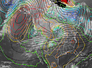
| IR Sat/GFS Forecast Valid ~1430 UTC 19 Nov 2010 |
 |
| IR Sat/RUC Valid 1500 UTC 19 Nov 2010 |
The trough lies within the so-called Great Basin cyclone region identified by Jeglum et al. (2010) as having a high frequency of Intermountain cyclone occurrence and genesis downstream of the High Sierra. Thus, although the existence of frontal troughing and baroclinity is consistent with the large scale pattern, I suspect the Sierra Nevada are enhancing the trough and influencing the position and intensity of the baroclinity over Nevada. See also Shafer and Steenburgh (2008) and West et al. (2010).
This pattern will persist over the next 24-36 hours as the large-scale trough amplifies and digs off the Pacific coast. Keep an eye on things and consider the role of the Sierra Nevada. In addition to how that mountain barrier affects mass and momentum, consider how it alters the thermodynamic and moisture characteristics of airmasses and how this in turn might affect the frontal and precipitation dynamics over the Intermountain West.

No comments:
Post a Comment