The latest GFS analysis and forecast loop shows that the ridge develops downstream of an explosively developing Pacific cyclone that is fueled in part by subtropical moisture, possibly related to Typhoon Chaba.

Friday, October 29, 2010
Tropical connections and extratropical mischief
As noted in the previous post, we are about to enter ski Purgatory, but why?
The latest GFS analysis and forecast loop shows that the ridge develops downstream of an explosively developing Pacific cyclone that is fueled in part by subtropical moisture, possibly related to Typhoon Chaba.
The UW WRF forecast progs a central pressure for the Pacific cyclone of 939 mb. A nice discussion of this event and its potential impacts on the PacNW is available on Cliff Mass' weather blog.
The latest GFS analysis and forecast loop shows that the ridge develops downstream of an explosively developing Pacific cyclone that is fueled in part by subtropical moisture, possibly related to Typhoon Chaba.
Welcome to Purgatory
For winter sports enthusiasts, we have officially entered the season of Purgatory, which is the boundary between Heaven (ski season) and Hell (fall).

It has snowed just enough to allow for turns on a limited amount of terrain. We'll have a bit more snow this weekend, and then it appears we are going to regress back not just to fall, but perhaps back to September. The GFS builds a monster ridge next week with 700-mb temperatures reaching over 8C!

This will likely lead to a near-total loss of the snowpack on southern aspects and major losses on east and west aspects. Northerly aspects will likely survive with more limited losses. The warmth will also make snowmaking difficult. Trevor's adjusted GFS output from this morning's GFS shows a temperature on Mt. Baldy of 51F by 5PM Tuesday.
On the otherhand, this will be a good dry run for PCAPS.
Thursday, October 28, 2010
Chapstick day in the mountains
Todays is a great example of what I call a Chapstick day. Dewpoints are so low in the mountains that you spend your whole day licking your lips and applying lip balm. There is a strong connection between skiing and Chapstick, not just for obvious reasons. Suzy Chaffee, a member of the US Ski Team during the 1968 Winter Olympics, was Chapstick's main spokesperson for many years, earning the name "Suzy Chapstick."

But I digress. This morning's sounding pretty much tells the tale as we have a series of stable layers in the lower troposphere with extremely low dewpoints (<-40C) between 600 and 725 mb.

Typically such dry conditions indicate that the air has subsided from upper-levels, which is consistent with the upper-level ridge that is presently over the region.
The Alta-Mt. Baldy mesowest station clearly shows these dry conditions as well, with dewpoints since about 0330 MDT running bellow -23C.

This is not as low as the sounding, which could reflect instrumentation errors at such low dewpoints or the influence of sublimation from the snowpack. The rapid drop in dewpoint at around 0330 MDT probably indicates when the subsidence advected the vertical moisture gradient below the elevation of the Mt. Baldy summit.
Wednesday, October 27, 2010
DLE strikes again
Great mid-lake band last night. One of the best I have seen in several years.
It's interesting to compare the last two nights and their contrasting lake-effect modes and intensity. I'll concentrate on 1200 UTC for brevity.
At 1200 UTC 26 Oct, there was a dominant wind-parallel band near Bountiful (a.k.a. the Bountiful Band). Temperatures were in the high 30s over much of the lowland regions, including the northern Wasatch Front from Bountiful to Ogden. Promontory Point was 29F with a WNW wind at 20 knots. Westerly flow was observed at HAT and at many of the locations near Ogden.

This morning, at 1200 UTC 27 Oct, there is a strong wind-parallel band near the major lake axis (a.k.a. the mid-lake band). Temperatures in the Ogden area are in the low 30s. Temperatures are also cooler over the Lakeside Mountains compared to the previous day. Promontory Point is 26 F with a NW wind at 15 knots. The flow pattern is remarkably similar to the previous day on the western side of the lake, but the flow in the Ogden area is primarily southerly.

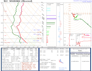
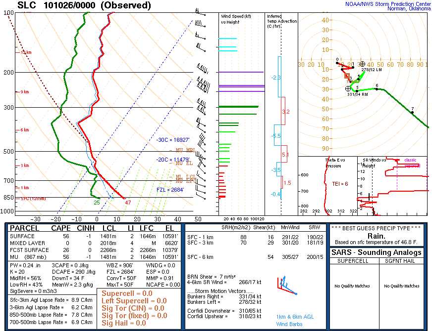
Consistent with the changes evident in the MesoWest data, comparison of the 1200 UTC 26 and 27 Oct soundings from KSLC (purple traces for the former) show 2-3C cooler conditions today below about 600 mb, which follows the the weak trough passage we observed last evening.

Hopefully this post will prompt some lively discussion.
At 1200 UTC 26 Oct, there was a dominant wind-parallel band near Bountiful (a.k.a. the Bountiful Band). Temperatures were in the high 30s over much of the lowland regions, including the northern Wasatch Front from Bountiful to Ogden. Promontory Point was 29F with a WNW wind at 20 knots. Westerly flow was observed at HAT and at many of the locations near Ogden.

This morning, at 1200 UTC 27 Oct, there is a strong wind-parallel band near the major lake axis (a.k.a. the mid-lake band). Temperatures in the Ogden area are in the low 30s. Temperatures are also cooler over the Lakeside Mountains compared to the previous day. Promontory Point is 26 F with a NW wind at 15 knots. The flow pattern is remarkably similar to the previous day on the western side of the lake, but the flow in the Ogden area is primarily southerly.

Consistent with the changes evident in the MesoWest data, comparison of the 1200 UTC 26 and 27 Oct soundings from KSLC (purple traces for the former) show 2-3C cooler conditions today below about 600 mb, which follows the the weak trough passage we observed last evening.

Some food for thought about this period:
- Is the convective mode of these two events really different? Are these simply wind-parallel bands of differing position and intensity or is there something fundamentally different about the underlying processes?
- Changes in position appear to be consistent with the large-scale flow differences, but how does colder environment, larger (inferred) lake-land temperature difference, and weaker flow/shear contribute to the more intense and organized band on the 27th? Are any of these more significant than the others, or do they all contribute?
- Is there any skill predicting such differences with a cloud-permitting model so that we can better forecast lake-effect intensity and position?
Hopefully this post will prompt some lively discussion.
Tuesday, October 26, 2010
SOLPEX IOP1 Wrapup
Sorry I'm running late on this blog update. SOLPEX IOP1 has reached a conclusion. Our final radiosonde launch was at 1500 UTC this morning, giving us a full diurnal cycle of sampling. Amongst the highlights of the overnight period was a fairly persistent wind-parallel band that developed near Bountiful in an area that seems to be a magnet for such bands.
The so-called Bountiful Band persisted between 1100-1300 UTC, so our 1200 UTC launch from the east side site was perfectly placed and timed. The 1200 UTC MesoWest analysis shows that we never really got a decent offshore flow going last night.

At times, the flow on the east side had a bit of a northerly component, as evident in the 0230 UTC update. At 1200 UTC, there was also light SE flow over the northern Salt Lake Valley. Whether or not this was significant for the development of the Bountiful Band remains undetermined.
After 1500 UTC precipitation became increasingly scattered and less concentrated downstream of the lake, so our timing was good. We may get more lake effect tonight, but will be sleeping happily in our beds.
Thanks to everyone for helping make this first IOP a success.
Monday, October 25, 2010
SOLPEX IOP1 0230 UTC 26 Oct update
We are moving forward with the 0300 UTC sounding launches and keeping our fingers crossed that things continue to blossom over and downstream of the lake.
Over the past hour radar echoes have become more frequent and intense south and east of the Great Salt Lake, especially from the Bountiful-area mountains to the Cottonwood Canyons.

There has also been frequent cell development along a wind-parallel axis near the SE shore of the Great Salt Lake, not far from the east-shore launch site. MesoWest analyses show a nice confluence zone in this region. Compared to 2330 UTC the flow has weakened, veered (especially in the Ogden area), and temperatures have cooled more around the lake than at the Gunnison and Hat Island sites. We now have a marginally positive lake-land temperature difference. Hat and Gunnison are technically upstream of the lake, so this difference may be a bit underestimated.

The 0000 UTC KSLC sounding is a bit disappointing. With the cold-core aloft now downstream, mid-levels are a touch stable. The sounding is also very dry above the surface layer, although dewpoints at sites in the Lakeside Mountains and on Promontory Point are higher than indicated at comparable altitudes in the sounding.
Further, GPS-based PW was a touch higher than indicated in the sounding and has increased some since.

With our teams in place, all we can do now is hope that mother nature brings the goods and that the approaching short-wave ridge doesn't put too much of a damper on things.
Update: 0310 UTC
A few stations in the Bountiful/Ogden area are reporting winds with a downslope/offshore component for the first time tonight.

The 0300 and 0600 UTC soundings from the east shore could prove very interesting especially when compared to those earlier today.
SOLPEX IOP1 2330 UTC 25 Oct update
All is quiet on the Wasatch Front. MesoWest analyses suggest that the lake-land temperature difference is fairly neutral.

We'll do the 0000 UTC launch and then see how things transition following sunset. Keep your fingers crossed. There is a 500 mb short-wave ridge upstream that we hope won't put a damper on things.

We'll do the 0000 UTC launch and then see how things transition following sunset. Keep your fingers crossed. There is a 500 mb short-wave ridge upstream that we hope won't put a damper on things.
SOLPEX IOP1 2030 UTC 25 Oct update
Radar imagery has been fairly quiet the past couple of hours. The latest shows some areas of orographic precipitation from Little Cottonwood to the UT-ID border.

We've opted to move forward with the optional 2100 UTC sounding for a couple of reasons. The first is that the flows at the north end remain bizarre. Note the southerly flow at Locomotive Springs.

I've seen this before in lake-effect events and its always been a head scratcher. Trevor's model runs and observations thusfar today suggests perhaps some sort of wake effects in the lee of the Raft River range. A single sounding ob might make this hard to nail down, but perhaps it will help.
The second is that we are starting to see an increase in cumulus convection over the lake. In fact, todays visible satellite loop is really incredible. Despite the persistent northwesterly flow at upper-levels, once cal clearly see what appear to be retrogressing mountain waves in the loop.
It appears, however, that the waves are becoming increasingly progressive in the last hour or two. We'll see if this leads to anything or if the lake stays shut down as it often does in the afternoon. The flow is so strong right now that I wonder if the thermally driven flows can even get going.
SOLPEX IOP1 18 UTC 25 Oct update
Hopefully the 1800 UTC soundings are off. I've heard from the northend team and they report a remarkably deep layer of southeasterly low-level flow. More on this in a few paragraphs.
At 1800 UTC, the coldest pocket of 500 mb air was directly overhead. NWerly large-scale flow as found at 500 mb and also at 700 mb.

The strong 500 mb baroclinic zone draped across southern Utah and central Nevada supports a truly impressive 80 m/s jet stream. Pity anyone flying to San Francisco today.
The flow at the surface is more zonal with westerly flow reported at many stations, including Gunnison Island and Hat Island. This flow clearly decelerates as it approaches the northern Wasatch Mountains, with some evidence of perhaps some southward deflection. The flow on Promontory Point, commonly used by yours truly as an approximate steering layer flow for lake-effect, is NWerly. Further north at Locamotive Springs, winds are quite light and out of the north. Given the reports of SE flow by the northside team at Kelton, this suggests perhaps some sort of anticyclonic gyre in the wake of the Raft River Range.

At 1800 UTC, the coldest pocket of 500 mb air was directly overhead. NWerly large-scale flow as found at 500 mb and also at 700 mb.

The strong 500 mb baroclinic zone draped across southern Utah and central Nevada supports a truly impressive 80 m/s jet stream. Pity anyone flying to San Francisco today.

Over the past two hours, persistent orographic precipitation has fallen over the mountains east of Logan and over the upper Cottonwood canyons. An intense wind-parallel band formed downstream of the SE corner of the lake around 1622 UTC, then weakened and broadened, before dissipating. Whether or not this is lake-enhanced remains unclear. A similar band materialized earlier but did not appear to be connected to the lake. The coverage of radar returns appears to be diminishing presently.
SOLPEX IOP1 underway
Teams are presently en route to the north and east side observing sites. As promised by the models for several days, we had an exciting fropa and at 1500 UTC we are in large-scale, post-frontal, northwesterly flow.


The 12Z NAM produces some lake-effect tonight, but is a bit more excited about Tuesday night when we'll have down time. Let's hope mother nature opts to bring the goods early.

KMTX shows one fairly strong wind-parallel snowband near and downstream of Ben Lomond peak, although the lake likely plays little role in its initiation.

Our first soundings will be launched at around 1800 UTC (noon MDT). The 12Z NAM time-height for KSLC shows moist, unstable WNW flow persisting for most of the overnight period.

The 12Z NAM produces some lake-effect tonight, but is a bit more excited about Tuesday night when we'll have down time. Let's hope mother nature opts to bring the goods early.
Vagaries of mountain precipitation observations
The Collins observing site at Alta (CLN) is one of the most reliable remote mountain precipitation sites in North America, but not today.
Note how the snow depth has increased 5 inches since 2 am MDT, but no precipitation has been reported by the gauge.

I suspect that the gauge bridged over with snow or clogged up during the intense precipitation that fell during fropa (in fact, that's when the gauge stopped reporting), or it was befallen by some other calamity.
Fropa was really impressive at my place. Our bedrooms are on the north side of the house and our windows made quite a racket as they were pelted by rain and graupel. Add in the thunder and lightning and you have the most exciting night of weather in several months.
Sunday, October 24, 2010
First tracks...
Nope, I wasn't skiing today, but I am thinking about where one might go in a couple of days to get the first turns of the year.
The snow level is quite high today, lingering above 9000 feet or so. As a result, there's little accumulation at the base of Alta. On the otherhand, the Snowbird cam shows about 6 inches in Gad Valley and the Ballroom and Mount Baldy look pretty good in the Alta weather cam photo.

Presumably with strong S-SW winds there's alot of wind deposition up high in the main Baldy Chute, where snow accumulations will be greatest until the front goes through late tonight.
Once the front goes through, the flow never quite comes fully around to northwesterly. If that verifies, accumulations might not be as great in the Cottonwoods as in the northern Wasatch.
As such, it could be difficult to find the sweet spot. Perhaps the Main Baldy Chute will offer up the goods. On the otherhand, maybe better turns will be had on the grassy (and admittedly lower angle) slopes of Snowbasin.
Finally, there is the very real possibility that we'll need another storm or two to put us over the top. The GFS, however, looks favorable for that to happen in the next week to 10 days.
Name and explain this cloud
Frequently in large-scale southwesterly flow a beautiful cap-like cloud appears on Lone Peak, with a tail over the Traverse Range. The cloud often ascends into a stratiform cloud deck aloft. Indeed this is the case this morning.

This cloud is so distinctive and common that I've always wondered what this type of cloud is known as scientifically and if it has a local name. I've called it a cap cloud for lack of a better term, but admit it looks more turbulent than a typical lenticular.
This morning's sounding shows stable conditions above 700 mb, consistent with the altostratus. At low levels, however, the lapse rate is near dry adiabatic.

If the cloud is forming in this layer of weak stability, perhaps this helps explain the turbulent appearance.
If anyone has any good ideas or analogs from other regions, please chirp in.
Saturday, October 23, 2010


Beware tailgaters
With an hour before kickoff of the Utes-CSU game, and ominously dark cloud mass and outflow boundary loom to the west. The radar doesn't look half bad for a fall storm either.

There's going to be some wet tailgaters. An ongoing concern of mine is a severe thunderstorm hitting the stadium during the game. Let's hope this one passes without incident.
Looking good for first SOLPEX IOP
Things are looking good for the first SOLPEX IOP with both the NAM and the GFS predicting large-scale conditions conducive to lake effect on Monday and Tuesday. The 12-km NAM shows cold-frontal passage sometime after 0000 MDT Monday,

then produces periods of lake-effect (and orographic precipitation) for about a day and a half, including Tuesday morning, which would be favored climatologically.

I believe the NAM uses climatology for lake temperatures, which probably underestimates current lake conditions. Things look good, but I've seen lake-effect smiles turn to lake-effect frowns before, so I'm trying to keep my enthusiasm tempered. Right now we are hoping to do an IOP Monday morning through Tuesday. WRF runs covering the period of interest should begin to come available tomorrow.
Friday, October 22, 2010
Kid in a candy shop
When Richard Reed retired from the University of Washington in the 1990s, he was one of the leading atmospheric scientists and a member of the National Academy of Sciences. What did he say at his retirement party? "When it comes to the atmosphere, I still feel like a kid in a candy shop."
I have that same feeling today as I do every year before the first big mountain or lowland snowstorm. It's the same feeling I had when I was a kid in NY and hoping that the forecast nor'easter would bring the goods, cancel school, and let me go skiing. I keep looking at the NAM forecast for the next few days and the anticipation is killing me!
If you feel the same way, you're in the right profession. You too are a kid in a candyshop.
Thursday, October 21, 2010
Salt Lake's First Flakes?
(Note: images can be clicked on for a larger view)
Excitement has been building for a number of days (weeks, for the ensemble users) now regarding the potential for some snowfall early this upcoming week. Although models have trended slightly warmer for this event over the past several days, it looks like we still have a situation that is marginally supportive of snowflakes reaching the valley floor sometime during this period. Given the time of year, I would expect that seeing this happen between 10am-6pm is unlikely, but I can't rule it out.
It looks like the first chance for snow to occur would be Sunday night, when 700mb temperatures fall below -7.5 C and a brief surge of moisture pushes through. Given the initial airmass saturation and cooling that will have to occur, I'm not too excited about that one.
The second chance arrives Monday evening and overnight into Tuesday morning. During this timeframe, the GFS is showing temperatures right around -8 C as a new surge of moisture pushes overhead (shown below). Given the nearly westerly flow regime, the lifting of this airmass as it encounters the mountains should be dramatic. This looks like a really good opportunity for snow above 5000 feet with some heavy bursts at higher elevations. However, the situation in the valley may be different, as the model sounding shows a decent melting layer at the surface.

The third and final chance is currently forecast to be Tuesday evening and overnight. This occurs as 700mb temperatures plunge to near -10 C, but the better RH fields move off to the east (shown below). Also during this time, model soundings indicate a very thin melting layer at the surface, which would allow flakes to more easily reach the valley floor (below as well). One final scenario is that the best combination of good moisture and low enough temperatures occurs Tuesday afternoon, but has trouble battling the diurnal cycle.


Hopefully, the models will soon converge on a solution as to the best time frame for the occurrence of any snowfall.
Wednesday, October 20, 2010
Beware when the atmosphere is in outlier mode
It appears that a major large-scale flow transition will occur over the next few days, one that is bound to produce high-impact weather over the western United States.
It's always good to be alert when the atmosphere is in "outlier mode." We've been in outlier mode the last few days with the strong Rex Block, but we're going to be in a different sort of outlier mode in a couple of days.
The 108 h GEFS forecast from 18Z 20 October (from PSUs E-wall) clearly shows a "honking jet" (to use a scientific term) over the eastern Pacific poking its nose into the western US.

Strong cyclonic and anticyclonic height anomalies flank this jet. Often, we look for unusually deep cyclones to identify when exceptional weather may occur, but in this case, neither of these anomalies is all that impressive. Instead, it is their meridional collocation that yields an exceptionally strong Pacific jet.
In addition to major changes in surface sensible weather, this is a recipe for nasty terrain-induced gravity wave activity. It will not be a fun time to be flying across the western United States.
Monday, October 18, 2010
Down the stretch they come
NCDC is reporting that the first nine months of 2010 are tied with 1998 as the warmest Jan-Sep period in the instrumented record. Will 2010 be the warmest on record at years end?

Some have argued that the Earth has been cooling since 1998, in part because the surface-temperature records maintained by the Climate Research Unit at the University of East Anglia (CRU) have 1998 as the warmest year on record. Observational uncertainties and interannual variability, however, make year-to-year rankings quite misleading and invite cherry picking by people on both sides of the political debate. This is the meteorological equivalent of the BCS rankings.
For an in-depth discussion of how all these temperature records are produced and what they mean, see Hansen et al. (2010). Figure 10 offers a nice synopsis of the 12-month running mean temperature (rather than calendar-year averages) along with the ENSO Nino3.4 index.

I suspect that 2010 is going to fall just short of 1998 in the NCDC record because of the strong La Nina that has developed, but that doesn't mean that long-term global warming is over.
This paper is "da bomb"
This month marks the 30th anniversary of one of the most important synoptic meteorology papers of the late 20th century. Synoptic-Dynamic Climatology of the "Bomb" by Fred Sanders and John Gyakum not only has a great title, but it also set the stage for a blossoming of research on extratropical cyclone dynamics and evolution that culminated with the GALE and ERICA field programs.

Sanders and Gyakum (1980) credit Tor Bergeron for first characterizing cyclones that deepen at a rate of at least 1 mb/hr for 24 hrs as rapidly deepening. Today, we use the term explosively deepening, which perhaps derives from Fred and John's use of "Bomb" in their article.
Some historical background is needed to put Sanders and Gyakum (1980) in perspective. Today we are all products of the Internet age in which live satellite and high resolution (0.5 degree or better) global analyses with variational satellite radiance assimilation stream to us 24/7. In 1980, operational Geostationary satellite imagery was barely a decade old and the highest resolution model run by the National Meteorological Center (today's National Centers for Environmental Prediction) was the Limited Fine-mesh Model (LFM), which had horizontal grid spacings of 127 or 190.5 km depending on generation (Silberberg and Bosart 1982).
The LFM was the primary model used for forecasting when I started in college and we had various nicknames for it, the most family friendly being "Lousy Freaking Model." Although cutting edge at the time, the LFM was indeed bad by today's standards. A 72-hour forecast today has more skill than a 36-hour forecast in 1980.

Sanders and Gyakum (1980) includes several important findings that helped guide extratropical cyclone research in the 1980s and 1990s:
Subsequent field programs (GALE and ERICA) examined the dynamics and evolution of marine cyclones, while a third, STORM-FEST examined continental systems. Research spawned from these field programs illustrated the importance of air-sea interactions for preconditioning the atmosphere and subsequent condensational heating for explosive deepening.
In the 1980s some thought that explosively deepening cyclones were poorly forecast because the NWP models were missing a piece of key physics. Instead, they were missing sufficient resolution to capture key non-linear dynamical processes, although advances in modeling and data assimilation have certainly contributed some to improved extratropical cyclone forecasts over the past three decades.
Today, events like Snowmaggedon are forecast days in advance. Of course, we still have work to do in the Intermountain West...

Sanders and Gyakum (1980) credit Tor Bergeron for first characterizing cyclones that deepen at a rate of at least 1 mb/hr for 24 hrs as rapidly deepening. Today, we use the term explosively deepening, which perhaps derives from Fred and John's use of "Bomb" in their article.
Some historical background is needed to put Sanders and Gyakum (1980) in perspective. Today we are all products of the Internet age in which live satellite and high resolution (0.5 degree or better) global analyses with variational satellite radiance assimilation stream to us 24/7. In 1980, operational Geostationary satellite imagery was barely a decade old and the highest resolution model run by the National Meteorological Center (today's National Centers for Environmental Prediction) was the Limited Fine-mesh Model (LFM), which had horizontal grid spacings of 127 or 190.5 km depending on generation (Silberberg and Bosart 1982).
The LFM was the primary model used for forecasting when I started in college and we had various nicknames for it, the most family friendly being "Lousy Freaking Model." Although cutting edge at the time, the LFM was indeed bad by today's standards. A 72-hour forecast today has more skill than a 36-hour forecast in 1980.

Sanders and Gyakum (1980) includes several important findings that helped guide extratropical cyclone research in the 1980s and 1990s:
- Explosively deepening cyclones are primarily (but not exclusively) maritime phenomenon.
- Explosive deepening occurs preferentially in regions of strong SST gradients, such as along the Gulf Stream and Kiroshiro Current.
- Quasigeostrophic dynamics cannot explain the rapid pressure falls.
- Current NWP models poorly forecast these events.
Subsequent field programs (GALE and ERICA) examined the dynamics and evolution of marine cyclones, while a third, STORM-FEST examined continental systems. Research spawned from these field programs illustrated the importance of air-sea interactions for preconditioning the atmosphere and subsequent condensational heating for explosive deepening.
In the 1980s some thought that explosively deepening cyclones were poorly forecast because the NWP models were missing a piece of key physics. Instead, they were missing sufficient resolution to capture key non-linear dynamical processes, although advances in modeling and data assimilation have certainly contributed some to improved extratropical cyclone forecasts over the past three decades.
Today, events like Snowmaggedon are forecast days in advance. Of course, we still have work to do in the Intermountain West...
Sunday, October 17, 2010
The 10-day wishcast
This morning's GEFS is showing remarkable spread at 10 days, which allows for great "wishcasting". Wishcasting is all about introducing bias into your forecast based on what you want to happen. The 240 hour GEFS forecast has something for everyone (image below courtesy of PSU E-wall).

If you want a deep trough, go with member P002. If you want a good snowstorm, perhaps C001 is your member of choice. Or, if you want the nice weather to continue, maybe P007 instead.
Of course the real question when the ensemble looks like this is what do you communicate to your customer. The ensemble mean is probably close to climatology, but you have members that show a major change in the weather for Utah that could be important. A difficult challenge, but one that savvy meteorological communicators can address.
Saturday, October 16, 2010
Welcome to the Rex Block
We have a nice example of a Rex Block setting up over the western US this week. A Rex Block features a high over low configuration at upper levels, with easterly flow between. They are not unusual over the western United States.
The GFS dynamic tropopause forecast below provides a bit of a "modern" view of the Rex Block, which is often described in terms of 500 mb height. Note the pronounced anticyclonic PV anomaly over the northwestern United States and cyclonic PV anomaly over the southwest, with easterly flow between.

These two anomalies are closely related as the wave breaking event responsible for the anticyclonic PV anomaly also provides the necessary deformation to compact and fracture the cyclonic PV anomaly. This is readily apparent in the 06 UTC 16 Oct GFS forecast available here and suggests that Rex Block development may be intrinsically related to anticyclonic wave breaking in the presence of a downstream neck of cyclonic PV.
With "severe clear" conditions in place last night, Pony Express Marker (PEM) had a 52F diurnal cycle. Not bad, but not as great as seen in September.

This may change tomorrow as the NAM remains fairly optimistic about the development of clouds and precipitation as the Rex Block develops and the cyclonic PV anomaly approaches and fractures off the Pacific Coast.
Thursday, October 14, 2010
Fall haze is upon us
We have officially crossed the meteorological brink from summer into fall. There is insufficient solar heating this week to build a convective boundary layer (CBL) that extends to crest level (~700 mb). The sounding from Tuesday afternoon shows a nicely developed CBL, but it tops out at about 775 mb.


CBL development yesterday was even more pathetic as slight warming above the surface kept it capped off at just above 850 mb.

Haze was quite apparent both afternoons, although DAQ observations from Hawthorne Elementary School suggest PM2.5 levels remain well below ambient air quality standards.

Nevertheless, as a caveman would put it, we are moving quickly from "ridge good" to "ridge bad" territory. What's unfortunate is that we could use some storms now for SOLPEX and some ridging in December for PCAPS. On the otherhand, as discussed in an earlier post, a dry October is good for skiers.
Wednesday, October 13, 2010
Wither Northern Hemisphere winter?
There is an article by Choi et al. in this month's Journal of Climate examining changes in Northern Hemisphere snow cover from 1972/73 to 2007/08.
Using weekly snow-cover extent maps generated by NOAA and National Ice Center meteorologists (derived primarily from visible satellite imagery), they examine two measures of snow season: (1) the full snow season (FSS), which is the interval between the first appearance and last disappearance of snow cover and (2) the continuous snow season (CSS), which is the longest interval with an unbroken string of weeks with snow cover.
Curiously they find little hemispheric trend in CSS duration. In other words, on a hemispheric scale, the period of continuous snow cover has changed little during the study period. On the otherhand, they find that the FSS duration has decreased at a rate of about 5.3 days/decade. This decrease is due primarily to an early offset (or end) of snow cover in the spring. This trend is pronounced in the western United States.

I find these results to be broadly consistent with prior literature on western US climate. Warming trends in recent decades are more pronounced in the spring than the fall (perhaps due to the snow-ice albedo effect) and one would expect precipitation and snowfall from spring storms to be sensitive to warming since temperatures are likely near freezing.
Given the warts in snow-cover datasets, it will be interesting to see how this study is scrutinized in coming weeks. Also at issue is trend attribution, which was not addressed by the authors. At issue is whether or not the hemispheric and regional changes are due to global warming from greenhouse gasses, decadal-scale variability, or other factors (e.g., black carbon, dust).
Tuesday, October 12, 2010
Great LCC stratus surge
The trailer for the latest ski movie from the Wasatch's finest contains a great clip of a stratus surge into LCC at about 2:29-2:34. Front or late afternoon cold pool upslope? Free trailbreaking from yours truly for whoever figures it out. The trailer is worth watching anyway as I'm sure several of you can remember skiing some of the lines featured. I think I recognized an aspen or two. I certainly remember the face shots.
Powerful storm in southeast Alaska
Southeast Alaska is no stranger to "crappy" weather. If you want to know what it's like to visit Ketchikan, where the average annual rainfall exceeds 375 cm (150 inches), go stand in a carwash for a couple of hours and you'll have a pretty good idea.
Over the weekend, a powerful storm with sustained winds of 40 m/s (hurricane force) and an estimated gust of 50 m/s) struck the Ketchikan area. A tree fell on a power substation, causing all the residents in Alaska's 5th largest city to lose power for 12 hours.
As damage cleanup continues, the area is about to be rocked again by another landfalling cyclone. The GFS and satellite analysis below shows the low-center to be just upstream of SE Alaska this morning.

With the large-scale pressure gradient still not aligned along the coast, winds in SE Alaska remain tolerable.

That will change, however, once the surface occluded front, evident as a tongue of warm air in the GFS analysis (red contours), makes landfall and the large-scale pressure gradient aligns aligned along the coastal orography. This is a classic scenario for widespread strong winds in SE Alaska (localized strong winds occur in a variety of patterns depending on local topography).
Monday, October 11, 2010
Time for a "Cool Change"
There's not much to talk about today, so I have to reach deep for this post.
One of my favorite 70s pop songs is Cool Change by the Little River Band, an Australian group that had a number of hit singles in the late 70s and early 80s.
Cool Change has meteorological connotations, which partially explains why I like the song. It is the popular name for summertime cold frontal passages in southeast Australia, which produce dramatic temperature falls as hot continental air is replaced by cooler air from over the Southern Ocean (Smith et al. 1982). They bring welcome relief, with one cool change this summer described as ending "misery at the gates of Hell." Wish I was there for that one. A close cousin is the onshore surge of marine air that occurs in the Pacific Northwest of the United States (Mass et al. 1986).
So, as we experience a weak baroclinic trough passage today, be sure to give Cool Change a listen.
Sunday, October 10, 2010
GEFS forecast good news for skiers
Our run of relatively mild, dry conditions looks to continue as the GFS and the GEFS (below) show continued high-amplitude ridging over the western United States for another several days.

We have not used the GEFS yet in map discussions, so a little introduction is in order. GEFS=Global Ensemble Forecast System and it is based on the GFS. Based on slightly different initial conditions, it provides an ensemble of forecasts that can be used to help ascertain forecast probability. The image above shows the GFS height forecast as contours (sometimes referred to as the control) with the "spread" of the ensemble members color shaded. In this case, there is very little spread in the high-amplitude ridge forecast over the western United States. In other words, all the ensemble members are "going for it." This gives us some confidence that the forecast will verify.
On the other hand, the weakness of the GEFS ensemble is that the spread is not calibrated. In other words, the mean and variance of the ensemble may not reflect real-world probabilities. Such ensemble calibration represents an important area of ongoing research.
Now, why is a ridge forecast good news for skiers? Early-mid October snowfalls may provide a day or two of fun, but they also tend to sit and rot when the next ridge builds in. This leaves a nasty layer of faceted snow that creates problems for backcountry avalanche safety when the snows start to pile up in November and December. My dream season starts with a warm dry October (with good mountain biking), followed by a snowy November. Maybe this is the year.
Friday, October 8, 2010
DLE makes an appearance
It appears in the loop below that lake-effect precipitation initiated this morning over and downstream of the GSL.

Note the quasi-wind-parallel bands near Ogden and environs, consistent with the primarily westerly flow found at and above 800 mb in the 12Z KSLC sounding. The 12Z MesoWest analysis below shows light SE flow in the Ogden area with 47-50F temperatures, in contrast to the 50-52F with WSW flow found at Hat and Gunnison "Islands", which presently lie just upstream of the west shore of the lake.

At issue is what role the apparent east-shore cold pool and SE flow plays in the initiation of the bands. Is there an area of convergence providing the necessary lift for convective initiation, or are the boundary layer circulations induced by heat and moisture fluxes over the lake sufficient? Other ideas?
Subscribe to:
Posts (Atom)