Friday, November 30, 2018

State of the Snowpack

The last week has been a godsend for Wasatch snow.  Precipitation totals (water equivalent) since Thanksgiving (11/22) are now at about 3.5 inches at Alta Collins and 4.5 inches at Snowbasin Middle Bowl. 

Source: MesoWest
With 8 inches overnight, the total snow-depth sensor at Alta Collins cracked 40 inches, which officially marks the beginning of "early season skiing" based on the Steenburgh snow-depth scale. 

Source: MesoWest
If you are wondering, I consider anything before we get to 40 inches to be "pre season."  Some might grumble about that number being too high, but remember that this blog is about mountain meteorology and snow snobbery.  

Here's something we haven't seen around here in a while, SNOTEL stations with above median snowpack water equivalent.  Paraphrasing Gordon Gecko, "green is good" (blue is even better) and there's quite a bit of it on the map below.  Relative to median, here are a few specific numbers: Snowbird 95%, Brighton 128%, Thaynes Canyon 116%, Mill D North 72%, Ben Lomond Peak 135%, Ben Lomond Trail 191%.  


It's early in the season, so percentages like those can be a bit misleading.  For instance, a station with 2 inches of snowpack water equivalent on the ground and a median of 1 inch is at 200% of median.  Thus, a better metric is the actual water content of the snow on the ground.  If we consider 5 inches to be the start of early season skiing, as a friend mentioned to me the other day, the following sites mentioned above are now above that mark: Snowbird (5.3), Brighton (5.5), Thaynes Canyon (5.1), and Ben Lomond (6.5).  

A special shoutout to Ben Lomond Trail which at 5972 ft sits at 4.2 inches of water equivalent.  Looks like North Fork Park is now grooming for skinny skiing, although the nordic center is not open yet for rentals.  See http://www.ogdennordic.com/.

Enjoy the early season bounty and keep the snow dances going. 

Thursday, November 29, 2018

Remarkable Fog Display

Looking south from the upper Aves at around 7 AM this morning
Yesterday's precipitation fell with little wind, allowing for to develop overnight along the Salt Lake Valley floor.  This has led to a difficult commute in some areas and some spectacular views from bench areas above the fog, such as the upper Avenues pictured above.  I am hoping that the Bay Area feel of the view might be a good omen for the Utes as they prepare to face the Huskies in Santa Clara on Friday for the Pac-12 Championship.

The fog was also evident from the top of the tram at Snowbird. 


Time lapse video from campus, compiled by Brian Blaylock, was really fascinating to watch and illustrates the complexity of local flows and wind shear that exists within the Salt Lake Valley and how rapidly they can change, even in a relative quiescent flow pattern.  Wait for it at 10 seconds.


Wednesday, November 28, 2018

A Multimodel Perspective on This Week's Mountain Snow

Although it is not unusual for the GFS to be wetter than the NAM, the difference between the two models over the next couple of days is exceptionally large.  For Alta from 5 AM this morning through 11 AM Saturday, the 0600 UTC initialized NAM generates 0.84 inches of water and 12 inches of snow.  In contrast, the 0600 UTC initialized GFS generates 2.84" of water and 39 inches of snow. 

There are several reasons why this is the case, but a major one is the track and characteristics of the storm that will move across the region Thursday night and Friday.  The NAM produces a trough that is displaced further south with precipitation occurring mainly near and south of the Salt Lake-Utah County line.


In contrast, the GFS trough is further north and precipitation occurs all the way up into southern Idaho.  There are also some details about the upper-level trough orientation that are different, but which I won't get into here. 


Although I do not have comparable 4-panels to the one above for the experimental FV3 model, which will eventually replace the current GFS, it too favors the more northern track with precipitation into southern Idaho. 


Another perspective is provided by the SREF plume for Alta.  There are 26 members in this ensemble and 24 of them produce at least 1.5 inches of water and fall in the range between 1.5 and 3.25 inches of water.  However, there are two members that lean toward a NAM-like solution, producing less than an inch of water.  Note how the main difference in these members is what happens after 0000 UTC 30 November, which would be that critical Thursday night and Friday period. 

Finally, the ECMWF model is producing 1.5 inches of water for the period at Alta and has a solution close to the GFS and FV3. 

The tendency in such situation is to toss the outlier solutions and focus on the meat of forecast distribution, which would probably yield a forecast calling for 1.5 to 2.5 inches of water at Alta from now to 11 AM Saturday (01/18Z in the plumes above), which would probably translate to 15 to 30 inches of snow given the anticipated snow-to-liquid ratios.  However, I've always felt that one should be cognizant of the full distribution, so a better interpretation is that 1.5 to 2.5 inches of water and 15 to 30 inches of snow is the most likely outcome, with lower odds that  the trough tracks to the south and we end up drier or that the wetter solutions verify.

My suggestion is that you all do snow dances to ensure that the NAM solution does not verify. 

Tuesday, November 27, 2018

More on the South Track Storms

The post is a bit redundant with the previous, but it's been so long since I've seen a model forecast like the GFS 10-day loop below that I feel the need to share it.  Check out the action across the southwest. 


The European model is generally similar for the first 6 days or so, but deviates quite a bit on the last few days of the loop.  In addition, the GEFS shows a wide of solutions at 10 days.

Source: Penn State E-Wall
Thus, perhaps the GFS run might overdo the persistence of the southerly storm track, but we can still enjoy seeing it as it sprinkles some variety into our lives.

The downscaled 7-day NAEFS quantitative precipitation (water equivalent) and snowfall probabilities also show nearly the all the mountains of the western U.S. getting some action over the next week. 

For northern Utah, much will depend on how productive the bits and pieces are and how far south the storms track.  For once, we probably need to be hoping the storms shift a bit further north than a bit further south, as was the case last year when the storm track was to our north for much of the winter.  I picked the NAEFS plume for Brighton today for a change of pace.  The most productive period is probably from about 0000 UTC 30 November through 1200 UTC 1 December, which would cover Thursday night through Friday morning.  Mean water (snow) totals for the entire 7 day period produced by the GEFS is about 1.75 inches (25 inches), with the Canadian as usual being more optimistic. 

Probably the best chance for snow will be Thursday night through Saturday morning.  Note that the large spread in these solutions, and the different accumulation rates that one can infer from individual plumes indicates some uncertainty and the intensity and timing of periods of snow during the period.  Nevertheless, things look good that we'll continue to build the snowpack at modest rates. 

Monday, November 26, 2018

Some Storminess for the Southwest U.S.

The next 7-10 days we will see something that we've seen little of over the last few years (with one notable seasonal exception) and that is a series of storms affecting the southwest U.S.

The loop below covers the period from 1200 UTC 24 November through 1200 UTC 1 December with jet-level wind speeds in excess of 40 meters per second (80 knots) color filled.  Note how the jet stream over the eastern Pacific and most of the US is south of 40ÂșN for much of the period, especially after 1200 UTC 27 November (5 AM MDT Tuesday).


With the storm track to the south, the southwest will be seeing a series of storms and getting some much needed precipitation.  Over the next 10 days, the GFS is putting out over 4 inches of water equivalent the Sierra Nevada (peaks over 6 inches) and more than 2 inches in higher altitude areas of Utah and western Colorado.


This is not a pattern with a huge tap of persistent, tropical moisture.  Thus, water totals are not ginormous, but that's probably a good thing.  Over the next seven days, the downscaled NAEFS product is generating a mean of just over 4 inches of water equivalent and 40 inches of snow for the Central Sierra Snow Lab near Truckee, CA, with most members putting out over 2.5 inches of water and 25 inches of snow.

The Wasatch will see something from these storms as well.

Sunday, November 25, 2018

A Look Back at the Model Guidance

I thought it would be worth taking a quick look at how our downscaled NAEFS ensemble forecasts did for the storm-total precipitation over Thanksgiving weekend. 

Below are forecasts plumes from the 0000 UTC 20 November downscaled NAEFS forecasts for Alta-Collins, Brighton, and the Canyons Lookout observing site.  I've added red bars to each of these showing the Utah Avalanche Center reported water equivalent and snowfall amount in upper-little Cottonwood, Big Cottonwood, and the Park City area mountains. 

The result is a bit of an apples and oranges comparison since the forecast is for a point and the observed amounts are from several sites, but there's no data available for snowfall and precip at the Canyons Lookout site and for snowfall at the Brighton site.

For the most part, the observed water equivalent and precipitation fell within the ensemble range at all three sites, although the lower water and snowfall totals in Little Cottonwood were just outside of it.  Observed water equivalent and snowfall at Brighton and Canyons Lookout were very close to being centered in the middle of the ensemble plume.  By and large, these are good results and certainly far better than what one would get using the low-resolution NAEFS without downscaling. 

That being said, one should not expect observations near the center every time.  The purpose of an ensemble is to produce reasonable probabilities for event sizes and sometimes lower probability, outlier events are going to verify.  Nevertheless, one likes to see the observations fall within the ensemble range and for the ensemble to produce a plume that is as narrow as possible. 

I've been a little concerned that the downscaling is producing too much precipitation for Alta Collins.  This is a hypothesis, but for that site, I'm thinking the downscaling might be producing too much in all but post-frontal convection events with northwesterly flow, when I suspect the downscaling will underdo it. 

One other thing to keep an eye on is the experimental GFS-FV3, which will replace the current operational GFS later this winter.  I haven't had time to do a proper look at each model for the entire period, but did look at how they did for Friday when the weather was drier than advertised and noticed that the GFS-FV3 (top) was wetter than the operational GFS in our neck of the woods. 


The FV3 is available on weather.utah.edu, so keep an eye on it and post comments when you see how it does.

Saturday, November 24, 2018

Game Changer

I write this around 8:15 AM Sunday morning.  I've been up for a while already as I was awoken by the remarkable frontal passage early this morning.  The meteogram from the Salt Lake City International Airport shows as clear a frontal passages as you'll ever see between 445 and 450 MST (1145 and 1150 UTC) with an abrupt shift in the wind from southerly to north-northwesterly and temperature falls of about 5F in 7 minutes and 8F in 9 minutes. 

Source: MesoWest
The front was accompanied by a narrow band of strong radar reflectivity, evident in the yellow color fill below. 


Twitter user @UtahWxMan took this great photo of the shelf cloud accompanying the front as it moved through Bountiful.  

For the most part, the past three days have produced as expected.  Through 8 AM, the Snowbasin Middle Bowl site (7400 ft) has recorded a total since Thanksgiving of nearly 2.6 inches of water.  

Source: MesoWest
Alta-Collins sits at just under 1.8 inches, which translates to 22 inches based on my adds of the increments on the interval stake.  


The forecast for today is a bit tricky, which reflects the usual post-frontal crap shoot.  It appears the frontal precipitation may linger for a couple of more hours in the Cottonwoods.  Then we'll have to see on the instability snowshowers.  For many days, the models called for a quick shutdown, but they've been a bit more bullish recently.  The HRRR, for example, is generating post-frontal bands that I would describe as somewhat unrealistic in their intensity and spacing, but perhaps indicative that we will have some shallow instability to play with this afternoon.  


So, perhaps another 2-5 inches at Alta Collins from 8 to 11 AM and then we'll see what the post-frontal crapshoot can produce.  

Two aspects of the storm cycle that we're not as well forecast were the break yesterday, which produced a nicer day than expected, and the persistence of the overnight warmth, which led to temperatures as high as 33.5˚F at the base of Alta at 4 AM this morning.  Temperatures also reached 33.7˚F at the Snowbasin Middle Bowl site (7400 ft).  While I wasn't surprised to see warm temperatures ahead of the front, I thought we would have seen peak temperatures earlier during the storm, perhaps Friday afternoon or early Friday night.  This reflects a stronger trough, which led to flow with a more southerly component in the pre-frontal environment, and may have limited overnight snowfall in the mid elevations.  

By and large, however, this is a game changer, although sympathies to the Park City side of the mountain where accumulations have lagged (although that's not unusual).   Although there will be a break Sunday and Monday, forecasts show an active pattern later next week.  We'll have to see how it comes together.  

Wednesday, November 21, 2018

I Confess, I'm Excited

It's been a long time since we had a major storm cycle around here and I confess that I am really excited for the weather we will see this holiday weekend. 

The Thanksgiving trough passage is really just an appetizer.  The mashed potatoes and gravy, stuffing, and 25-pound butterball follow on Friday when a strong upper-level trough approaches the Pacific Northwest coast and moisture and precipitation spread inland into Utah. 


It's been a long time since we've seen a time-height section like the one below.  DEEP moisture for an extended period of time.  There is the Thanksgiving storm, then a bit of a break, followed by strong, moist, westerly crest-level flow for about an extended period before a frontal passage early Saturday morning. 

For the period ending 11 AM MST Saturday, the 12-km NAM is putting out just over 3 inches of water for upper Little Cottonwood. 


Through Saturday afternoon (5 PM) the SREF ensemble mean for Alta Collins is around 3 inches, although the range is quite large (.9 to 4.8 inches). 

I lack the time to talk about some of the nuances of the forecast, such as how shadowing in the lee of the Oquirrhs sometimes reduces precipitation rates in Little Cottonwood during westerly flow, while the northern Wasatch does well.  Further, such details might best be left until we can see of the whites of the storms eyes, and we're not quite there yet.  I'll just say that this appears to be a major storm cycle, with total accumulations of 1.5 to 3 inches of water and 18 to 36 inches of snow from Thursday through Saturday in the mid and upper elevations of the central and northern Wasatch.  I don't see us getting skunked in this one.  Snow levels will probably peak Friday afternoon or early Friday night in the warm pre-frontal flow.  Briefly they could get up to around 7000 feet, but could stay lower as this is an instance where one tends to see a deep layer that is near the melting point and precipitation intensity often controls the snow level. 

Details concerning snow levels, the timing of precipitation, and the intensity of precipitation are not possible to predict with precision at such long lead times.  If you are traveling over the holiday weekend, monitor forecasts at https://www.weather.gov/slc/ as this is a blog post, not a forecast, and I can't do anything but hit the highlights. 

If you are wondering, right now, the weather looks dry statewide on Sunday. 

Tuesday, November 20, 2018

This Forecast Had Better Not Be a Turkey

In writing this post, I am assuming that you are more interested in seeing some snow for skiing than dry weather for going over the river and through the woods to Grandma's house.

We begin with a quick look back at the past so we can put the forecast into proper perspective.  You might recall that the season started out with  12 inches on the 9th and 30.5" of snow for October at Alta, which is probably fairly close to average.  Since then, things have quieted down, with only 12.5 inches of snow falling so far in November.  Variable snow conditions exist, with no snow on sun exposed slopes, even at upper elevations, and rotten, faceted snow on upper-elevation north aspects.  The photo below, from Trent Meisenheimer's most recent Utah Avalanche Center report, shows a snowpack in Martha Bowl that "was completely faceted and rotten to the ground."


That should cause a shiver to go up the spines of backcountry skiers.  On the plus side, the cold weather has allowed the resorts to make snow and several will probably be open with limited terrain this weekend.

Through Wednesday, the forecast continues to look dry and pleasant, albeit with some smog in the valley.  Pre-thanksgiving mountain biking looks quite nice tomorrow afternoon as the ridge exits, the next storm makes landfall in California, and the pre-frontal southerly flow begins to increase.  This might allow temperatures on the benches to rise into the 50s.  There also doesn't look to be any major weather concerns statewide tomorrow.


That changes on Thanksgiving, with a trough bringing precipitation pretty much statewide.  Current forecasts show snow levels  dropping Thanksgiving morning and flirting with the benches and valley floors by afternoon.  It will be worth keeping an eye on forecasts if you are traveling.


Then, a more powerful trough approaches from the northwest.  This leads to a period of strong, moist, westerly flow Friday and Friday night, with a frontal passage currently projected for Salt Lake City late Friday night/early Saturday morning.  It's probably easiest to show this in a time-height section (see below).  Remember that time increases to the left.  This shows the deep, dry airmass presently resident over Salt Lake City persisting through tomorrow afternoon, the trough passage Thanksgiving followed by a quick break, then the moist westerlies, and the frontal passage.

How we do in the pre-frontal westerlies is a bit of a crap shoot.  Sometimes those can be productive, other times, they turn into virga storms.  Let us hope for the former.

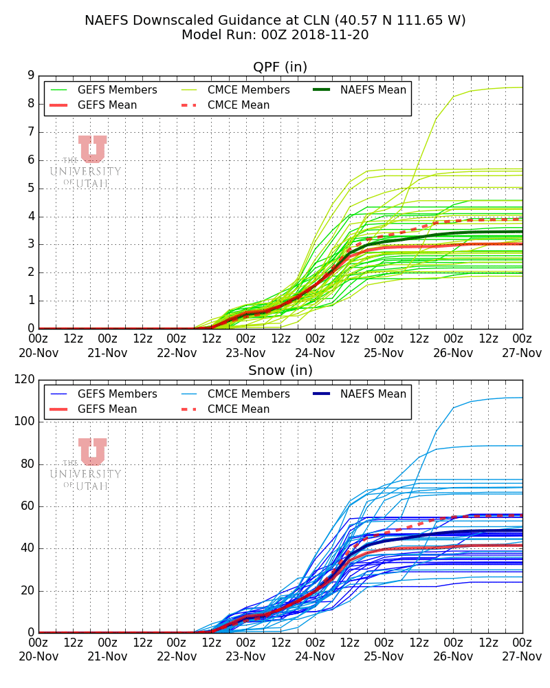
Our downscaled NAEFS forecast for Alta shows a range through 0000 UTC 25 November (5 PM MST Saturday) of about 1.8 to 5.5 inches of water and 21 to 70 inches of snow (note that I'm not discussing the last two days through 0000 UTC 27 November, which are also included in the graphic below). 

While there is a tendency to fixate on the high numbers, the reality is that they are produced by outlier ensemble members and are low probability possibilities.  It's also good to sobering up by recognizing that the lower end ensemble members are producing 1.8 inches of water and 20 inches of snow and that 0000 UTC 25 November represents a 5 day forecast.  A decent total for the period is likely, but let's see how things look in a couple of days.  For the backcountry crowd, even low amounts with wind are going to create all sorts of avalanche problems, so also keep an eye on reports from the Utah Avalanche Center. 

Sunday, November 18, 2018

Snow for Thanksgiving Weekend?

Yesterday's frontal passage did little to put a dent into the November snowfall drought, generating an inch on the Alta Collins snowfall stake.  Sadly closed for uphill skiing and a close personal inspection, I suspect that there will be decent top-to-bottom skiing at Alta when they open, even if the terrain is limited, thanks to assistance from artificial snow.

Hopefully, we will also get some help from Mother Nature over Thanksgiving weekend.  For the past few days, the models have been suggesting some storm systems will move through the area during that period, but amounts have been variable.  The latest NAEFS ensemble is looking up a bit, however, with all ensemble members producing precipitation at Alta-Collins on Thanksgiving (22 November) and then periods of precipitation through the 24th (Saturday). 

For most ensemble members, the totals being produced by our downscaled NAEFS product plotted above vary from about 1.2 to 2.7 inches of water equivalent and 18 to 35 inches of snow for Alta-Collins.  The Canadian has a few very excited members, but also a couple less excited members. 

That's about the most optimistic forecast I've seen since our early October storm.  Let us hope it delivers.  Keep up the snow dances and keep an eye on the forecasts the next few days as this is an evolving forecast situation. 

Friday, November 16, 2018

Local Pollution or Smoke?

Looking toward the central Wasatch Mountains from the Avenues Foothills 3:30 PM Friday 16 November 2018
A lot of people have asked me if the haze in the valley is smoke from the fires in California.  There is probably a small amount of smoke that is in our area, but for the most part, what you are seeing in the valley is pollution of our own doing.

The vast majority of the smoke from the California fires remains over the central Valley, Bay Area, and offshore Pacific ocean, although there is some that extends eastward across the Great Basin.  This is illustrated by the HRRR-SMOKE analysis below for near-surface smoke concentrations.  Note that the HRRR estimates near-surface smoke concentrations to be 4 ug/m3 or less over northern Utah.   

Source: ESRL
I'm not sure how much to trust that estimate, but let's go with it.  PM2.5 concentrations on the University of Utah campus today have been running around 14 to 20 ug/m3, much higher than the HRRR smoke estimates.  Note that over the past two days the values have fluctuated dramatically, dropping to as low as zero overnight and then rising during the day.  This reflects the development of a down-canyon flow in Red Butte Canyon (the observing site sits at the mouth of the canyon), which brings clean air from aloft (above the smog layer evident in the picture above) at night.  This is another reason why I'm skeptical about smoke being a strong contributor to our current pollution.  We simply don't have much evidence of high smoke concentrations aloft.

Source: MesoWest
Finally, November IS part of our wintertime smog season.  The sun angle right now is plenty low and comparable to that in late January.  Further, we do have a persistent cold pool in place over the Salt Lake Valley.  Yesterday afternoon, for example, a series of stable layers just above 5000 feet prevented pollution from the valley from mixing with the atmosphere aloft.  If there were snow on the ground, we'd have a whopper of an "inversion" event. 

Source: SPC
So, as I like to say, we have met the enemy and it is us.  The good news is that the weak cold front coming through late tomorrow should stir things up.  However, we go back to ridging early next week, so consider taking the bus or alternative modes of transportation if you can do it.  

Thursday, November 15, 2018

Is Our Recent Spate of Bad Novembers "Unusual"

As far as I'm concerned, November can suck it.  I'm tired of mountain biking in the cold, wishing I was skiing.  Yeah, it's cold enough for snowmaking, but I don't live in Utah to ski fake snow.  I'd rather have some warm weather that's more enjoyable in the valley. 

It's worth taking a look at historical November snowfall at Alta Guard, where the US Forest Service and now the Utah Department of Transportation have kept records back to 1945.  The average November snowfall is 69 inches, although there is great variability (note that 1972/73 is missing in the graph below). It is also apparent that the 1980s and early 1990s were exceptional for November snowfall, with the 10-year running average (thin line below) peaking at over 100 inches in the early 1990s.  November 1994 was the ultimate with 206 inches. 


At issue is this.  Is our recent string of bad Novembers really all that unusual, or were the snowy 1980s and early 1990s the true outlier?  As far as total snowfall is concerned, recent Novembers are not all that unusual compared to the late 50s through the 1970s in terms of total snowfall.  Sadly, we don't have snowfall records going back for several hundred years to put the last 15 years or so into context. 

Note that this does not mean that the climate has not changed (it has) or that the mechanisms responsible for the recent spate of bad November snowfalls aren't different than they were in the late 1950s through 1970s.  Those are issues that would require a much more in depth analysis than I can do for a quick blog post.  However, I do believe it is worth recognizing that the 1980s and early 1990s were exceptional snow years in many ways and that they may not represent the true "average" climate of Utah, even before global warming began to accelerate. 

Tuesday, November 13, 2018

Santa Ana Air Quality Oddities

The Camp and Woolsey Fires in California, which have been fanned by Diablo and Santa Ana wins, have produced a true wildfire catastrophe.  The 7 PM 12 November incident update for the Camp Fire near Chico reports 42 civilian categories and over 7,000 structures destroyed, including 6,453 single residences.  It is now the deadliest wildfire in California history.  The incident report for the Woolsey fire near Thousand Oaks and Malibu, also updated 7 PM 12 November, reports 2 civilian fires and 435 structures destroyed, although this is an estimate.

I happened to be in the Los Angeles area this weekend.  One of the oddities of Santa Ana conditions is that in the absence of fire and smoke, they produce good air quality and visibility.  Below are a series of MODIS images for 9, 10, 11, and 12 November.  In the top image (9 November), the Woolsey fire was raging with strong Santa Ana winds blowing the smoke plume offshore.  The LA basin was smoke free.  On the 10th, however, the flow shifted and weakened, and smoke infiltrated much of the urban area.  That smoke lingered into the 11th, although it is difficult to see in the imagery.  Finally on the 12th, conditions cleared again, with smoke emissions lower.


We arrived in Los Angeles Saturday morning and drove straight to the San Gabriel Mountains and the Mt. Wilson Observatory as from the plane it appeared the visibility was good and the air clear.  Indeed we found that to be the case when we arrived at the observatory.


However, smoke was beginning to spread into the LA Basin as we left the ridge top.


On Sunday, although we had planned some hikes in the hills, the smoke was bad enough in the morning that we elected to tour art museums instead.


Monday I had a morning meeting, but afterward we made a quick stop at the Santa Monica Pier on the way to the airport.  The smoke from the Woolsey Fire was clearly subdued compared to earlier days and with the offshore flow the weather was postcard perfect.  Quintessential SoCal. 


What a paradox that the weather and air quality can be so good in one place while catastrophe is unfolding not far away.  Sadly, we still no not fully comprehend the losses from these fires as there are still many missing and the fires continue to burn.  Red Flag Warnings are currently up for the Woolsey Fire area through 5 PM this afternoon, which will mean another difficult day of firefighting conditions and the potential for rapid spread of spot fires from blowing embers or new ignitions.

Note:. Post has been updated to correct spelling of Santa Ana.