Friday, October 30, 2020

Stand Up for Dr. Angela Dunn

State epidemiologist Dr. Angela Dunn lives a few blocks from us.  Earlier this week, her address was released on social media and groups gathered at her house yesterday in protest.  This is a diabolical act of harassment and intimidation that cannot stand.  Picketing of this type at someone's residence is also likely illegal.  I am not sure what codes apply within the Salt Lake City limits, but Salt Lake County has an entire section of code dedicated to this issue and classifies it as a Class B misdemeanor.  

Dr. Dunn is not an elected official.  She is a civil servant who has had to do a very difficult job.  In the tweet below, her neighbor, Mark Cronin, shares views that are similar to mine.  


Although not at the same level or scale, I have some experience with intimidation tactics, including state legislators threatening to pull the funding of my climate collaborators and an individual who aggressively shouted at me after testimony for a state legislature committee.  I no longer remember the details of that encounter, but I recall that I was concerned the individual was going to become violent and defused the situation by slowly moving closer to a nearby police officer.  Such experiences were the exception and not the rule, but they were difficult nonetheless.

However, nobody every showed up at my house to picket me and my family.

Where are we as a nation when epidemiologists like Dr. Dunn and Dr. Anthony Fauci need bodyguards and police for protection?  Where will be be in a few more weeks as hospitalizations and deaths mount due to the spread of coronavirus in Utah and many other states?  We need them more than ever and we must stand up for their right to do their jobs without harassment or intimidation.  

This does not mean that people cannot question or protest, but they need to use appropriate methods for doing so.  With rights come responsibilities.    

Wednesday, October 28, 2020

A Late October Inversion

Although inversion "season" doesn't begin until November 1, the reality is that we're in a pretty good inversion right now in late October.

Here are a couple cherry-picked observed temperatures at 7 am this morning:

  • Salt Lake City Airport (4226 ft): 30˚F
  • Snowbird SNOTEL (9177 ft): 40˚F

This morning's sounding from the airport shows a surface temperature of 32˚F.  You have to go all the way up to 13,397 feet (about 600 mb) to find a colder temperature.  

Source: SPC

That's where the free-atmosphere freezing level is.  You can find pockets of sub 32˚F air at the surface across northern Utah where overnight cold pools developed or cold air from the weekend cold surge persists in valleys, basins, and canyons, but beyond that, there's a mild airmass now in place. 

On Monday, Alta was making snow.  Look closely and you can see the guns running in Collins Gulch.  

Source: Alta.com

This morning?  It looks like they've either given up are are doing it in localized spots.  

Source: Alta.com

Nevertheless, a few resorts are doing what they can in the cold low spots.  The dryness of this airmass lends an assist since evaporation and sublimation of the droplets or ice particles created by the snow gun locally lowers the temperature.  

Source: Deer Valley

Meanwhile, haze was quite apparent in the Salt Lake Valley yesterday and PM2.5 concentrations pushed into the low-end of moderate in the Salt Lake Valley.  They have dropped back down into good overnight, but I suspect we'll see moderate air quality again this afternoon.  

Source: Utah Division of Air Quality

I'm not concerned about this becoming an air pollution event like we see in winter when there's snow on the ground and the sun angles are even lower.  Yesterday afternoon's sounding showed the boundary layer — the surface-based layer in which turbulence mixes pollution and other atmospheric variables — extended to about 6000 feet.  

Source: SPC

That's deeper than we see in our wintertime air pollution events.  

Model forecasts through Friday show similar conditions, so we will see some haze and perhaps higher PM2.5 levels, but probably not getting above high moderate levels.  

A weak frontal passage Friday night should stir things up a bit, but snow is unlikely and temperatures will not cool all that much.   Weather monotony continues.  

Monday, October 26, 2020

Yup, It Was Cold

Bit of a late post for me today due to other pressing concerns.  

Portions of the western United States are in the grips of an impressive cold surge for late October.  For Salt Lake City, it's not as far out there as last year's, when we had minimum temperatures of 17˚F and 14˚F on October 29 and 30, but it's still cold.  Last night's minimum was 19˚F, a record for the day and the 2nd earliest 19 on record (the earliest was recorded on October 25th).  

For those of you on the Wasatch Back, valley temps dropped to below zero near Park City including -5˚F at Silver Creek Junction and -4˚F along SR-244 at Meadows.  It also got down to -5˚F at the top of the Snowbird Tram.  

Alta-Collins' snow-depth sensors were pretty finicky overnight and today.  There could be a couple of inches of snow there, or maybe a 115" base.  I'll let you decide if you want to go up and check it out.

Peter Sinks normally brings the goods in patterns like these, but the wind didn't cooperate (more snow might have helped too).  Observations show temperatures falling to about -13˚F just after midnight, when there was a bit of an increase in the wind, stirring the cold pool and causing temperatures to rebound to about 3˚F.  Cooling thereafter only brought the temperature down to -20˚F, balmy by their standards.  


Brian Brettschneider reports that the -31˚F reported in Lyman, WY was the earliest -30˚F reading for any official climate station in the Lower 48 on record.  Impressive.  
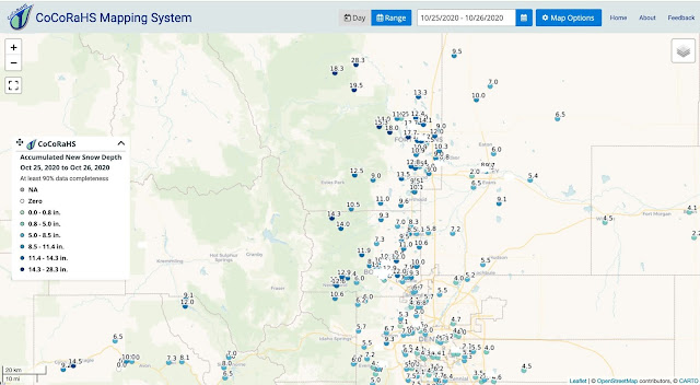
If you're looking for snow, some good numbers in Colorado below, as reported by CoCoRaHS and the Colorado Climate Center.


For once, I'm more than happy to let them have it for the fires. 

Friday, October 23, 2020

Flakes for Salt Lake City?

This weekends storm looks to be "meh" like the last, although we might see a few flakes in Salt Lake City.  

The models agree on a cold frontal passage through northern Utah on Saturday with some precipitation in it's wake eventually moving in late Saturday or Saturday night, but there are differences in the timing and amount of precipitation depending on the track and intensity of the upper-level trough.  As things stand now, this looks to be a "central Wasatch skipper" with the odds and amount of precipitation greater in the mountains to the north, south, and east, as illustrated by our downscaled SREF product below, covering the period ending 0000 UTC 27 November (6 PM Monday).    


I'd be perfectly fine with this storm skipping us and going to Colorado as they could use the fire-fighting assistance and a small storm will do us no good for skiing at this stage.  

In terms of snowfall, odds of more than an inch are about 50-60% in the upper elevations of the central Wasatch and > 90% in the upper elevations of the western Uintas.  Odds are also > 60% in high elevation areas of central, southern, and eastern Utah.

However, the odds of > 6" are low (<10%) in northwest Utah including the Wasatch Range.  In high-elevation areas of southern Utah, there are modest odds of > 6" and some slim chances of a significant storm.  

At Alta-Collins, the downscale SREF shows a trace to 3 inches of snow being produced by 25 of the 26 ensemble members, some generating that snow with the cold frontal passage on Saturday, others lateron Sunday.  One member has some late snow showers on Monday.  In any event, these numbers are fairly paltry and only one member approaches 5 inches.  No reason to get excited, said the joker to the thief.  

A wider range of possibilities is possible to the south.  For instance, at 10,000 feet on the Manti Skyline, there are SREF members that produce trace amounts, but others that generate 7.5 to 17".  It turns out that low-snow members are those using one model formulation (the "NMB), whereas the high-snow members use another (the "ARW").   


I suspect we'll see convergence around a solution in one of the forthcoming model cycles, so if you are planning to recreate in this area on Sunday or Monday, be sure to catch an update and monitor NWS forecasts, but be aware of the possibility of upper-elevation snow.  

Finally, we have the plume for Salt Lake City.  There are two challenges for snow at the airport.  One is whether or not there's any precipitation.  The other is that when there is precipitation, the temperatures are marginal (note that it will be plenty cold here Sunday afternoon and Monday, but during that period it's likely to be dry).  It looks like 9 ensemble members call for virtually nothing, whereas the remaining 17 members give amounts ranging from trace to jus over half an inch.  


Not much to get excited about, but we haven't had much in the weather department for a long time.  


Thursday, October 22, 2020

East Troublesome Fire Blowup

 It's October 22nd.  I repeat October 22nd.  

Yesterday, the East Troublesome Fire in Grand County Colorado exploded.  It's worth taking a look at a couple of fire maps to illustrate the explosive growth.

At 2055 on the evening of October 20th, the fire perimiter covered 19,086 acres.  

At 0030 hrs on the evening of October 22nd, it was 125,602 acres.   


I am now seeing reports that the fire has jumped the Continental Divide to the east slope of the Front Range.

Radar imagery from yesterday shows no echoes associated with the fire at 1911 UTC (1311 MDT).

Source: NCAR/RAL

By 2057 UTC (1457 MDT), echoes extended from the fire area near Granby (GNB on the map below across the Continental Divide, an indication of both explosive growth and strong flow.  


Observations from Kremmling, just upstream of the fire, over the past five days show that yesterday was the warmest day of the period, with the lowest relative dewpoints and relative humidities.  Winds were stronger and more sustained from the southwest as well.  

Source: MesoWest

Observations from the Granby Airport tell a somewhat similar tale.  Yesterday was a couple of degrees warmer than the previous day, with lower dewpoints and relative humidities.  Wind gusts were also stronger. 

Source: MesoWest

Additionally, the flow at 700 mb, about 10,000 ft above sea level, also strengthened.  Analyses for 0000 UTC 21 October (1800 MDT Tuesday) and 0000 UTC 22 October (1800 MDT Wednesday) and show an increase from 10-15 knots to 20-25 knots between the two days.  


Note also that the 700mb temperature increased about 4˚C, even greater than the maximum temperature increase at valley stations, and that radar echoes appeared yesterday afternoon with the fire blowup.  

As much as I like to poke fun at Colorado for its minimal snowfall and powder days, I am rooting for them to bet a big dump and bring an end to this fire season.  

Wednesday, October 21, 2020

Colder Air Is Coming

With the end times near, today would be a good day to get out and enjoy the mild fall weather.  It should be sunny and warm by seasonal standards.  Tomorrow will be colder, a harbinger of things to come.  

The first blow to mild fall weather comes this evening in the form of a cold front that the HRRR forecasts to be moving through Salt Lake City at around 0400 UTC (10 PM MDT).  

The front will spread across Utah tonight and tomorrow, with strong northerly to northwesterly flow and colder air in its wake.  

The National Weather Service forecast highs for the Salt Lake City International Airport today and tomorrow are 72˚F and 52˚F, respectively.  A bit of a breeze will make the change feel even more dramatic. 

Then the weekend is "interesting."  First, we have a brushby system on Saturday.  The GFS forecast keeps most of the precipitation to our north and northeast, with just a few light valley showers and high-elevation snow showers.  

A consult of our SREF downscaled precipitation product shows a sharp contrast in precipitation probabilities from the Wasatch Front to the the northeast corner of the state.  


The plumes for Alta Collins show that 23 of the 26 members produce less than 3 inches of snow through 0000 UTC 25 October (6 PM MDT Saturday).  Three go for 3-6.5 inches.  


With the GFS producing paltry amounts and the Euro also producing light accumulations, the odds are stacked for this to be a dust on dirt event, with about a 10% chance we see more than 4 inches.  

Snowmakers will be happy though as we see some cold October air pour into the state Sunday and Sunday night.  The forecast below, valid 0900 UTC (0300 MDT) Monday shows 700-mb (10,000 ft) temperatures down to -14˚C!


That's not record setting territory, but it is cold, and it will produce temperatures in the single digits at 11,000 feet.  This will be a good opportunity to test out the snow guns.  

Monday, October 19, 2020

Don't Bet on the GFS (Or the "Euro" for that Matter)

I frequently see people on social media talking about a medium- or extended-range forecast produced by the GFS.  Alternatively, they might talk about a forecast produced by the ECMWF Integrated Forecast System, the so called "gold standard" of medium- and extended-range forecasting and commonly referred to as the "Euro" or ECMWF.

Don't take the bait.  

It's not that those forecasts aren't useful.  They can be, but only when viewed with the range of possibilities produced by an ensemble forecast system.  

The reality is that a GFS forecast (or a "Euro" forecast) is only one solution.  It represents one of many possible outcomes based on what we know about the state of the atmosphere, ocean, land-surface, and ice cover when we start the model.  

As a result, the GFS produces a credible forecast, one that is physically realistic and believable.  It just might not verify with great veracity.

Let's take a look at the GFS forecast initialized at 1200 UTC Sunday.  The 159 hour forecast valid 0300 UTC 25 October (9 PM MDT Saturday) shows a deep trough over the interior western United States with a potent cold front draped across Northern Utah.  Freshies for Sunday.  Hooray! 

However, the GFS forecast initialized at 0600 UTC Monday is less exciting.  the trough is much weaker and over Wyoming and Montana.  The front is less potent and northern Utah is in more of a brush-by situation.  

When it comes to precipitation and snowfall, the details matter, and no single model forecast can reliably predict those details at such lead times.  Not the GFS.  Not the Euro.  Additionally, at such lead times, it is not uncommon for GFS forecasts to flop around a bit, forecasting something snowy one run, drier the next, and snowier again the next after that.  Such forecast whiplash is a reality of the chaotic nature of the atmosphere.

With that in mind, let's take a look at the downscaled North American Ensemble Forecast System guidance for Alta.  At lower left, one sees that the 52 members produce a wide range of outcomes.  Eight members produce more than 20" through 0000 UTC 26 October (1800 MDT Sunday), 9 members 10-20", and the remaining 35 members less than 10 inches, some less than 5.  


Such an ensemble forecast is not unusual for Alta.  There are no sure bets in this part of the world and situations like this with a digging trough in northwesterly flow are especially uncertain at these longer lead times.  

We've actually seen this movie before.  Remember last weekend's trough?  Very similar.  That doesn't mean it's going to play out the same way.  What it means is that we need to recognize the range of possible outcomes and be cautious about betting on one possible outcome at these long lead times.  

Saturday, October 17, 2020

Cold-Pool Season Is Coming

Although we've seen a substantial decrease in smoke in recent days, a look at the sky sometimes shows a bit of smog due to pollution along the Wasatch Front.  Here's an example from yesterday afternoon.

Inversion season is coming, and while it isn't here yet, on some days we're starting to see that the decrease in daytime heating due to the shorter days and lower angle sun is resulting in decreased mixing of the lower atmosphere and a bit more particular matter buildup. 

During the day, energy from the sun warms the ground and in turn the lower atmosphere, leading to turbulence and mixing.  The layer in which this occurs is known as the convective boundary layer, which I'll abbreviate as CBL.  The maximum depth of the CBL, typically achieved in the afternoon, depends on many factors, one of which is the amount of incoming energy from the sun.  

During the summer, the CBL in Utah can be very deep, sometimes extending to more than 10,000 feet above the valley floor.  Vigorous mixing in the summertime CBL prevents a buildup of particulate matter (although we can still get high ozone concentrations).  

During the winter, however, the energy available from the sun is much lower.  On many days, the CBL is very shallow, sometimes as little as a few hundred feet deep.  On these days, we see a build up of particulate matter.  Unless a storm comes through to stir things up, the situation tends to worsen with time.

We're not there yet, but we are seeing some of the effects of the decrease in solar energy.  Yesterday, for example, the CBL reached a depth of only about 3000 feet.  You can see the CBL in the graphic below, which is a thermodynamic diagram used by meteorologists and known as a Skew-T.  It shows the vertical profile of temperature (red), dewpoint (green), and wind (barbs to the right) above Salt Lake City from the surface to the upper atmosphere.  The y-axis is pressure, which decreases with elevation (meteorologists typically use pressure as a coordinate rather than height for a variety of reasons).

The CBL is the layer near the ground that I've indicated as "well mixed."  The surface temperature is 63˚F and above the surface the temperature decreases at a rate of about 10˚C per kilometer.  Such a temperature decrease is consistent with the air density being constant with height.  The air can mix vigirously through such a layer.  

SkewT source: NOAA/NWS/SPC

At the top of the CBL, however, there's a stable layer.  In this layer, the temperature increases with height.  Such a layer is stable and resistant to mixing. Additionally, it is capped by a weakly stable layer.  Together, this puts a lid on the atmosphere over the Salt Lake Valley, limiting mixing of the valley atmosphere at about mid-mountain level.  In turn, those mountains limit horizontal transport of the atmosphere, and we see a bit of pollution.  In the summer, the energy of the sun would be sufficient that the lower atmosphere would have warmed more and mixing would extend through a deeper layer.  However, it's now October, and there simply isn't enough solar heating.

The meteorological definition of inversion is a layer in which the atmospheric temperature increases with height.  In Utah, it's used differently in popular culture to describe a number of situations in which the air is trapped at low levels and pollution is building up.  Not all of these situations feature an inversion, but they do feature relatively dense low-level air is trapped near the valley floor.  A better meteorological name for such air is cold pool

Cold pool season is coming.  Cold pools are natural.  They have been a common cool-season occurrence in the valleys and basins of the mid latitudes, including Utah, for millions of years.  What is not natural are emissions due to human activity, one source of which is fossil fuel combustion.  Thus, this is another situation where we have met the enemy and it is us.  

Monday, October 12, 2020

After the "Deluge"

After days of anticipation, yesterday's valley rain and skiff of mountain snow was a nice change, but pretty meh.  Water equivalent precipitation observations reported to the National Weather Service in the Salt Lake Valley maximized at 0.39" at the City Creek Water Plant and included 0.29" in the upper Avenues, 0.19" at the Salt Lake Airport, and 0.14" at Olympus Cove.  Pretty paltry amounts and enough to wet the upper soil layers, but it remains parched below.  

In the central Wasatch, Alta reported 1.3" of snow with 0.23" of water equivalent and Brighton 2" of snow with 0.35" of water.  Dust on dirt and probably for the best as below-average precipitation looks to persist as the storm track remains to our north the next couple of days and the western ridge redevelops thereafter.  Hopefully Mother Nature is saving it for November.  

Although it would have been nice to get a better soaker, yesterday afternoon was spectacular.


Smoke-free fall weather continues today.  Enjoy!

Saturday, October 10, 2020

I Love October!

You'll be hard pressed to find a nicer Saturday than today.  Low humidity.  High temps in the 80s.  Low angle sun.  Fall colors at low elevation.  Spectacular.  


Just the pick me up I needed!  Get out and enjoy.  

Friday, October 9, 2020

Thoughts on Extended Forecasts and Pattern Changes

There's a saying amongst meteorologists that the severity of a storm is inversely proportional to the hype preceding it.  

I've seen tweets about this weekend's storm and a possible pattern shift going back about 10 days.  However, at that time, and as recently as a couple of days ago, the ensembles produced a wide range of possible outcomes from very little snow to quite a bit in the central Wasatch.  

The latest forecasts lean not toward a bit storm, but instead toward a solution with the heaviest heaviest precipitation going to our friends to the north including the Central Idaho Mountains and Teton Range.  We get a frontal passage and cooler air, but less precipitation.  For the 24-hour period ending 0000 UTC 12 Oct (1800 MDT Sunday), the ECMWF IFS gives valley locations in northern Utah only 0.2 to 0.3 inches of precipitation, which would fall as rain.  


Source: Pivotal Weather

That's one of the wetter models.  The GFS is between 0.1 and 0.25" for the Salt Lake Valley with a bit more for the mountains.  After we downscale and apply our snow-to-liquid ratio algorithms, the GFS yields 2-4" of snow above about 7000 feet and 4-8 inches at the highest elevations of the central Wasatch.  


The vast majority of downscaled ensemble forecasts favor a small event.  45/52 members of the NAEFS produce an inch or less of water and about 8 inches or less of snow for Alta.  6 members go for 1-2" of water and 12-18".  Then there's a plucky member of the Canadian ensemble going for over 50", but for reasons discussed earlier this week, discount that (I guess there's always hope).  


We can also look at the Short Range Ensemble Forecast system (SREF).  Its numbers are in line with the majority of the NAEFS members.  All SREF members are under 1" of water and 10" of snow.  Note that both the NAEFS and SREF have some members producing scant amounts of snow (2" or less).  


One shouldn't verify a forecast with a forecast, so we'll have to see how this ultimately ends up, but my view is it illustrates the importance of considering the full range of ensemble forecasts and not buying into any one possible outcome when several are presented.  

Additionally, if you look at the NAEFS, notice how the accumulated precipitation and snowfall traces are generally flat after Sunday's storm.  Although we some changes in the large-scale pattern in terms of a strengthening jet and storm track, that's happening largely to our north and the models suggest continued ridge dominated weather.  Something might slip through the net, but for the most part, extended forecasts suggest the dice are heavily loaded for continued dry weather.  

My view at this point is a best case scenario for Sunday would be some valley rain and very little mountain snow to allow upper-elevation hiking and biking to continue.  I think the odds of getting enough snow for skiing are nearly zero at this point, so a storm that lays down 12-18 inches would just be a waste.  

Thursday, October 8, 2020

Flies in the Ointment

Chances are you've been hearing about the pattern change we are going to experience this weekend for about two weeks.  Chances are you've been dreaming of it for at least two months.  It's going to happen, but for mountain snowfall, there are some flies in the ointment.  

As discussed in the previous post, the medium range forecasts from a couple of days ago exhibited a good deal of spread for precipitation and snowfall at Alta.  The North American Ensemble Forecast System (NAEFS) exhibited three solution clusters, one that produced light accumulations (two inches or less), a second that produced moderate accumulations (about 6-12 inches), and a few others that produced considerably more.  This reflected uncertainty in the speed and depth of the upper-level trough as it moved through the western United States.

There has been some convergence of the large-scale solutions produced by the models since then.  As shown by the thumbnails of the 32 members of the GEFS ensemble below, most ensemble members now call for a lower-amplitude, faster moving trough to sweep across northern Utah.  


Source: Penn State e-wall

Such a solution is fairly close to what the Global Forecast System (GFS) has been advertising the past couple of days.  The European Center for Medium Range Weather Forecasting (ECMWF) Integrated Forecast System has been calling for a deeper trough and more precipitation for northern Utah, but even it has shifted toward a lower-amplitude trough, as illustrated below.

Source: Pivotal Weather

With a shift to a lower-amplitude, faster moving solution, most of the members of our downscaled NAEFS product are calling for an inch or less of water equivalent at Alta (upper left panel below) during the Sunday storm.  Six of the 52 members (12%) go for more than an inch, with one member of the Canadian ensemble generating over 4 inches.  Mean snowfall is about 8 inches, with a majority of members producing in the range from zero to 18 inches.  


I am sometimes asked about the outlier members of the Canadian Ensemble.  The Canadian ensemble has a couple of members that are prone to producing very large localized accumulations.  When this happens in northern Utah, we get a couple of members that produce unrealistic accumulations.  In this instance, the outlier member produces about 50" of snow in 24 hours, which is highly unrealistic for a situation like this.  

I am also asked if a range of 0 to 18 inches is reasonable.  Can't we nail it down more?  This is a 72-96 hour forecast and my answer to that is probably not with current observing and modeling abilities.  In this instance, the driest solutions feature a weak trough that passes to the north, producing just light precipitation in the central Wasatch.  A bit deeper trough and you get more precipitation in the middle of the range.  A bit deeper than that and you start getting totals > 12".  Thus, there are sensitivities in snowfall due to uncertainties in the large-scale trough.  If we included the European ensemble, which has more members favoring the deeper solution, we would probably see an increase in the odds of snowfall in the 6-15 inch range and a decrease in the odds of lower amounts.  However, even in the European ensemble, the greatest range of possible outcomes in the trough intensity is found over Utah, as indicated by the shading in the map below.  


Source: ECMWF

Thus, we can be confident of cooler weather on Sunday (temperature is more predictable than precipitation and snow), but we can't completely nail down the snowfall forecast.  I'm hoping we come in with some valley rain and limited mountain snowfall as this really isn't a long-term pattern change.  The extended forecasts suggest the dice are loaded for below average precipitation after this trough passage.  Without more storms, early snow becomes weak snow on north aspects, and that's a recipe for avalanche problems when the storms return. 

Monday, October 5, 2020

Improving Medium Range Forecasts

In late September, the National Weather Service upgraded its Global Ensemble Forecast System, GEFS, which should lead to improved medium range forecasts for ski season.  

The upgrades include the following:

  • GEFS is now based on the new "FV3" dynamical core
  • Horizontal grid spacing decreased from 33 to 25 km
  • Members increased from 21 to 31 members
  • Use of new techniques to produce initial conditions for the members
For more details, see this NOAA Press Release or this Service Change Announcement.  

Time will tell if these upgrades lead to significant improvements, but I'm optimistic they will help some.  The increase in membership and new techniques they are using to initialize those members should help improve the spread of the ensemble, providing better probabilities of precipitation thresholds.  

What we don't know is how these changes are going to affect GEFS biases at individual locations and, in turn, how those biases will affect our downscaled forecasts.  It will take a few storms (maybe more) to start getting a handle on this. 

We will have our first chance Sunday and Sunday night when the first major fall system of the season looks to push through northern Utah.  Our downscaled NAEFS product, which includes all 31 of the new GEFS members, indicates an ensemble mean of nearly an inch of water equivalent in "favored" Wasatch Mountain locations through 0000 UTC 12 October (6 PM MDT Sunday) and 6-12 inches of snow for upper elevations around the Cottonwoods.  


For Alta-Collins, the GEFS mean is just under 12 inches.  Curiously, that's quite a bit higher than the Canadian Ensemble mean, which is a bit unusual.  There are three major clusters of GEFS members, one that produces two inches or less, a second that produces about 6-12 inches, and a third that is in the 18-28 inch range (see lower-left panel).  One very excited member produces more than forty inches ;-).  


A big question that I have at this point is whether or not these forecasts exhibit more bias than they did last year.  Are they skewed toward higher amounts, for example, or is the model and downscaling reasonably calibrated.  Large spread in this instance doesn't surprise me based on the characteristics of the trough, which is digging and closing off over the western U.S.  Such situations typically exhibit significant uncertainties for local snowfall accumulations since much depends on if, where and how the low closes off.  

I look forward to cooler weather, but would rather have the snow hold off a bit longer, especially if it's only going to be a modest event.  If it goes big, I guess I'm more interested, but even in that situation, it will likely rot on north aspects and melt elsewhere, so let's save it until a bit later in the season.  

Friday, October 2, 2020

Alex Rakes France and Utah Radar Upgraded

Here are a couple of items to distract you from pandemic-fueled political coverage today.  

Storm Alex Rakes Northwest France

A powerful midlatitude cyclone named Alex (such storms are named in Europe) moved across northwest France overnight, bringing damaging winds.  Below is a Meteosat loop showing the development of the system and its movement Bretagne and Normandy.  

Source: CIRA

The UK MetOffice analysis for 0000 UTC 2 October shows the low centered over nothwest france with a central pressure of 969 mb. 

Source: UK MetOffice

Peak wind gusts relayed through some of my channels by Tim Hewson of the ECMWF include 186 km/h (116 mph) on Belle-ÃŽle, and island just off the south coast of Bretagne, 157 km/h (98 mph) in Groix, 142 km/h (88 mph) in Granville, and 135 km/h (84 mph) in Sarzeau.  These are sites on or very near the Atlantic or English Channel coasts.  However, even inland, Cholet had a gust of 129 km/h (80 mph).

Northern Utah Radar Upgrade

The KMTX (Promotory Point) National Weather Service radar was installed in 1995 and celebrated its 25th anniversary this summer (see Happy 20th Anniversary KMTX! from five years ago for some background on its history.  This week, however, it underwent a major upgrade, lowering the angle for the lowest elevation radar scan from 0.5˚ to 0˚.  That doesn't sound like much, but it's important for a radar that sits on a mountaintop because it means that the radar will be able to sample lower altitudes over the Great Salt Lake and surrounding valleys and basins.  This means improved detection of precipitation systems and some forms of severe weather in all seasons, as summarized by the NWS infographic below.  

Source: NWS

Many of us have wanted this to happen since the install of the radar, but the upgrade has been tied up largely by politics (and perhaps some technical matters) for some time.  

If you are wondering, this change probably won't affect radar coverage in the Wasatch much.  The 0˚ scan is severely blocked by the initial western face of the Wasatch, so higher angle tilts, such as the 0.5˚, will remain important.  Most of the radar images I share for the blog are based on the 0.5˚ tilt, but the ones you see elsewhere may be hybrid or composite images constructed with information from multiple tilts as the NWS radars perform a series of scans at multiple elevations.  

Below are a couple of videos from the UCAR/COMET program describing how radar works and the operation of National Weather Service Radars.