Showing posts with label Fronts. Show all posts

Saturday, December 13, 2025

A Great Storm in Utah


A Great Storm in Utah is something we are all waiting for but is also an essay that John Muir wrote while visiting the Salt Lake Valley in 1877.  The essay was sent to me by a former student, Matt Jeglum, who knows how much I enjoy this sort of weather and nostalgia, and contained within Muir's book Wilderness Essays.

In the essay, Muir describes a storm on May 19, 1877.  The date is very close to the peak time of year for strong cold fronts in northern Utah and he was impressed.

"Utah has just been blessed with one of the grandest storms I have ever beheld this side of the Sierra.  The mountains are laden with frsh snow; wild streams are swelling and booming adown the cañons, and out in the valley of the Jordan a thousand rain-pools are gleaming in the sun." 

But before describing the storm, he provides some great observations of Utah snow and weather.  First, he suggests a late start to the snow season with snow piling up in the spring.

"In all the upper cañons of the mountains the snow is now from five to ten feet dep or more, and most of it has fallen since March." 

He also describes frequent afternoon thunderstorms, as we often see in the spring:

"Almost every day during the last three weeks small local storms have been falling on the Wahsatch and Oquirrh Mountains, while the Jordan Valley remained dry and sun-filled."

Then there's the storm, which sounds like it packed a wallop.  Read this passage out loud, pausing at each comma, for great effect.

"But on the afternoon of Thursday, the 17th ultimo, wind, rain, and snow filled the whole basin, driving wildly over valley and plain from range to range, bestowing their benefactions in most cordial and harmonious storm measures.  The oldest Saints say they have never witnessed a more violet storm of this kind since the first settlement of Zion, and while the gale from the northwest, with which the storm began, was rocking their adobe walls, uprooting trees and darkening the streets with billows of dust and sand, some of them seemeed inclined to guess that the terrible phenomenon was one of the signs of the times of which their preachers are so constantly reminding them, the beginning of the outpouring of the treasured wrath of the Lord upon the Gentiles for the killing of Joseph Smith."

Muir's essay describes blowing dust and sand (I suspect primarily the former).  In the passage below, I suspect he is describing pre-frontal virga (precipitation evaporating before it reaches the valley floor) and dust in the pre-frontal southerly flow.

"Clouds, with peculiarly restless and self-conscious gestures, were marshaling themselves along themountain-tops and sending out long, overlapping wings across the valley; and even where no cloud was visible, an obscuring film absorbed the sunlight." 

Muir loses me meteorologically for a bit in the passage below, but perhaps he is describing pre-frontal snow falling over the Wasatch and Oquirrhs while the Salt Lake Valley is still dry and perhaps hasn't mixed out yet to produce strong winds on the valley floor. 

"Some of the denser clouds came down, crowning and wreathing the highest peaks and dropping long gray fringes whose smooth linear structure showed that snow was beginning to fall.  Of these partial storms there were soon ten or twelve, arranged in two rows, while the main Jordan Valley between them lay as yet in profound calm." 

But then, the great front arrives, and it arrives at what is typically the optimal time for a strong spring cold-frontal passage with what I suspect is a dark shelf cloud and strong, dust-laden post-frontal winds.

"At 4:30 P.M. a dark brownish cloud appeared close down on the plain towards the lake, extending from the northern extremity of the Oquirrh Range in a northeasterly direction as far as the eye could reach. Its peculiar color and structure excited our attention without enabling us to decide certainly as to its character, but we were not left long in doubt, for in a few minutes it came sweeping over the valley in a wild uproar, a torrent of wind thick with sand and dust, advancing with a most majestic front, rolling and overcombing like a gigantic sea-wave."  

The essay continues to describe important meteorological details.  In particular, the rain followed the dark cloud and dust by an hour.  This indicates that the front preceded the frontal precipitation band and could have been an outflow boundary initiated by precipitaiton-cooled downdrafts beneath the frontal precipitation band.  Today we can see these details in many spring cold fronts thanks to surface weather observing systems and the National Weather Service radar. 

"The gale portion of the storm lasted over an hour, then down came the blessed rain and the snow all through the night and the next day, the snow and rain alternating and blending in the valley."

The description above also suggests that the precipitation persisted through the night.  Most frontal precipitation bands pass over Utah in a few hours, so perhaps there was a contribution from lake effect or orographic precipitation overnight.  The snow and rain alternating suggests the valley floor was probably in or near the melting layer with snow levels dropping during heavy precipitation periods and rising during lighter precipitation periods.  

Muir, however, did not find the snow in the city attractive or share a view that could be used by the Chamber of Commerce to attract tourists:

"It is long since I have seen snow coming into a city.  The crystal flakes falling in the foul streets was a pitiful sight." 

I include below a couple of photos of the essay describing the great storm.  Enjoy the reading. 


Wednesday, June 18, 2025

It's a Trough!

It will take a while to get here, but a bonafide trough will be coming to Utah for the weekend.

Before that, we're going to be in the so-called warm-before-the-storm (in this case a dry frontal passage with dust) with a ridge building over Utah today.


The ridge will be followed by the development of warm southwesterly flow ahead of the trough later in the week, as illustrated by the GFS forecast below for 0000 UTC 21 June (6 PM MDT Friday).


Although yesterday's high was "only" 87 and this morning was pleasant, our July like weather returns for the rest of the work week with NWS forecast highs for the Salt Lake City airport of 92 today, 102 Thursday, and 96 on Friday.  Critical fire weather conditions will be in place for much of this period.

Saturday is a transition day with the front forecast to be moving over northern Utah at 0000 UTC 22 June (6 PM MDT Saturday).  


Depending on your location and exposure, this looks like a recipe for dust Friday and Saturday in both the pre-frontal environment and the post-frontal environment.  Salt Lake City could see some wind-blown pre-frontal dust from origins to the south and southwest ahead of the front and then from the exposed Great Salt Lake once the front is through.  Good times.  

Once the dust has settled (pun intended), Sunday looks very pleasant with valley highs in the mid 70s.  It looks like a good day for a hike, but bring a couple of layers if you are going to higher elevations. Our GFS-derived forecast guidance for Little Cottonwood is calling for 34F at Alta-Collins (9600 ft) and 31F on Mt. Baldy (11,000 ft) at 9 AM and afternoon temps in the high 40s and high 30s, respectively.  

Sunday, June 1, 2025

First Day of June is Like July

 As I type this on Sunday afternoon (June 1), the temperature at the Salt Lake City International Airport is about 92°F at 2 PM.  The record for the day is 94°F, so we have a solid shot at tying or eclipsing that.  A high of 94 is also consistent with the average high for July 11, so we're getting a too early taste of mid summer.  

Fortunately a weak cold front is coming through tomorrow morning.  Tomorrow afternoon will be more pleasant than today with cooler, drier, northwesterly flow.  

Right now it's looking like the frontal passage will probably be a dry one in Salt Lake.  The NWS forecasts give us the not quite zero possibility of a shower or thunderstorm: "A slight chance of showers and thunderstorms before midnight, then a slight chance of showers between midnight and 3am."

Hopefully we see something, although my expectations are for nothing.  At least it will be cooler tomorrow.  

Tuesday, August 8, 2023

A Trough!

It's always exciting in the dog days of summer to see a trough embedded in the midlatitude westerlies pay a visit to Utah.

The GFS forecast below shows the trough moving through Utah at 1800 UTC (1200 MDT) August 8 (today).  At 700 mb there is even...wait for it...a temperature gradient with cold air advection (i.e., the transport of cold air into the area).  


It's difficult to find evidence of a well-developed front at the surface, but there is evidence of some enhanced northerly or northwesterly flow over the west desert and along portions of the northern Wasatch Front at around 8 AM this morning.  Winds in the Salt Lake Valley, which are often southerly or southeasterly in the morning if there's no large scale forcing, show a bit more disorganized character.   


That could reflect some of the showers that moved through, but also the fact that the surface trough is nearby or just downstream.  

The NWS forecast for today calls for scattered showers this morning and then sunny skies this afternoon with a high of...wait for it...81°F!  

ENJOY!

Tuesday, February 28, 2023

Oh What a Night!

You can't stop Mother Nature this season.  More insane numbers from the Wasatch.  As reported by the Utah Avalanche Center this morning, storm totals for the PC Ridgline are now .95–1.05" water and 15–22" of snow and Upper Cottonwoods 1–2.5" of water and 16–35" of snow.  The Ogden and Provo area Mountains have also been blessed with big dumps. 

Snowfall late yesterday was intense at Alta-Collins. Hourly snow interval observations show an increase in snow depth from 3 to 10 inches in two hours from 5 to 7 PM.  Normally the board is wiped between 4 and 5 PM, but I can't tell if that was done as the interval remained at 3 inches.  Given the intense snowfall rates, it is possible it was wiped and it basically was snowing 3" an hour starting at about 4 PM.   

I've heard that the Cottonwoods were a mess during this period and that the overnight road closure was moved up to 8 PM.  If so, I suspect both were closely related to the heavy snowfall. 

Radar observations during the period of heavy snowfall showed strong orographic enhancement of precipitation in the southern central Wasatch and Mt. Timpanogos area, with spillover to the Deer Valley Area.  There was also enhancement over the southern Stansbury and Oquirrh Ranges.  

The flow during this period was southerly at valley level and southwesterly at crest level and, perhaps most importantly, the dendritic growth zone, a layer in which temperatures are between -12 and -18˚C and conducive for the formation of dendritic, low density snow, sat right at and above crest level (10824–12762 ft as identified by blue lines in the plot below).   


All of these things are easy to spot in hindsight, but what separates a garden variety snowfall from an intense one is hard to identify reliably in advance.  Just because the ingredients are there, doesn't mean Mother Nature will bake the cake. 

Embedded in this storm was something that I don't understand.  For an extended period of time, a southwest to northeast oriented band developed over the Lone Peak Massif (just north of the cursor in the loop below) and extended downstream over Little Cottonwood and upper Big Cottonwood Canyons.  At ties, you can see siilar bands forming downstream of Mt. Timpanogos and even the southern Oquirrh Mountains.  


I have seen such features at times before and have event posted on them previously (see Something I Don't Understand).  They have been identified in the Alps, but I am not sure if the ones we see here are a close cousin or a distant relative.  Regardless, I wish we had a very detailed snowfall measurement network to identify the impact of this band on snowfall distribution in the Wasatch.  

Something else is evident in the loop above and that is the cold front that came through last night with a bang.  First the wind woke me up and then I saw a couple of flashes of lightning (but I heard no thunder).  I've heard reports of thunder and lightning around the area, and lightningmaps.org observed many strikes along the northern Wasatch Front, two in Tooele, one in South Jordan, and four in Utah County.

Source: lightningmaps.org

Paraphrasing Frankie Valli:

Oh, what a night
Late February back in twenty three
What a very special time for me
As I remember what a night

Tuesday, February 21, 2023

Here We Go

Super excited for the events to unfold later today through Wednesday.  The models continue to be on track with a major, all elevations snow event for Utah.  

The large-scale setup for this event is an amplifying upper-level trough that digs southward along the Pacific Coast.  As discussed in an earlier post, this amplifying system is actually connected to the development of two powerful cyclones over the northwest Pacific, which amplify the immediate downstream ridge over Alaska, which in turn amplifies the trough along the Pacific Coast through a process known as downstream development.  The GFS forecast valid at 0000 UTC 22 February (5 PM MST Tuesday) shows all of these features nicely with the northwest Pacific cyclones marked with Ls, the ridge with a zig-zagged line, and the trough with a dashed line.  

This is a highly dynamic situation with rapid amplification of the jet-stream pattern.  It is only through the power of numerical weather prediction that such a pattern change can be reliably anticipated days in advance.  We've been on alert for some time about this possibility, even if the details could not be confidently pinned down.  

As the upper-level trough digs down the Pacific Coast, the accompanying cold front slides into Utah.  The GFS forecast valid 0000 UTC 22 February (5 PM MST Tuesday, corresponding to the valid time of the hemispheric forecast analysis above), shows the cold front over central Nevada and northern Utah.  To the south of the front it is mainly dry.  To the north, heavy precipitation mainly in the form of snow.  


Note the sharp wind shift at 700-mb (10,000 ft above sea level) in the lower left hand panel above.  This is reflective of strong troughing that develops along the front downstream of the Sierra Nevada and extending across central Nevada and Utah.  

Eventually the cold front and associated trough become the locus for cyclogensis, falling pressures and the development of a low-pressure system over Utah.  By 1200 UTC 22 February (5 AM Wednesday), the low pressure system is centered over eastern Utah. 


In response to the developing cyclone, the front pivots over central Utah, surging southward through Nevada to the west, but stalling over the Uintas to the east.  The pivot point is somewhere near Provo, give or take 100 kilometers.  At 700-mb, a fully closed circulation develops that is roughly centered over Kamas at1200 UTC 22 February (5 AM Wednesday, lower left panel above).  This makes anticipating mountain effect on precipitation very difficult as much will depend on the track of that closed circulation and wind directions could change quite a bit during its passage.  Additionally, much will also depend on how far south the front pushes.  

I'll walk you through one model solution.  This is the high-resolution HRRR initialized at 1200 UTC (5 AM MST) this morning. The forecast valid 1800 UTC 21 February (11 AM MST Tuesday) shows the front just beginning to push into northwest Utah with some prefrontal precipitation over the central Wasatch, northern Wasatch, northern Wasatch Front, and Cache Valley.  Precipitation at this time would be valley rain and mountain snow, with perhaps some wet snow on high-elevation benches.  

By 0000 UTC 22 February (5 PM MST Tuesday), the front is on the doorstep of the Salt Lake Valley.  It is likely that precipitation has changed to snow at all elevations along the northern Wasatch Front and its probably just about to change to snow in the Salt Lake Valley.  Buckle up!


By 0300 UTC 22 February (8 PM Tuesday), the front has pushed through Tooele County and is entering Utah County at the surface, although the band is covering much of northern Utah County and southern Salt Lake County.  Expect heavy snowfall over the Salt Lake Valley this evening as the band moves through.  


Then the front stalls and begins to pivot.  The sequence of images below shows the frontal band lingering in the Wasatch Front region through 1500 UTC 22 February (8 AM MST Wednesday).


Periods of snow would likely occur in the Salt Lake Valley through that period, and then continuing into the day on Wednesday.  Accumulations will vary spatially and depend on local flow interactions with terrain.

The HRRR-derived snowfall forecast through 1500 UTC 22 February (8 AM Wednesday) is below.  I'll focus on accumulations through 8 AM tomorrow as that's a good time for both commuters and skiers, although periods of snow may continue through Wednesday.  The HRRR-derived snowfall forecast uses our University of Utah snow-to-liquid-ratio algorithm.  It calls for a big dump for the entire Wasatch Range with 18+ inches at all central Wasatch Resorts, 22 at Snowbasin, and 26 at Powder Mountain through 8 AM tomorrow.  The range in the Salt Lake Valley is from about six or seven inches to just over a foot at Cottonwood Heights.  If this forecast were to verify, the southeast bench would get the most snow in the valley.  

That's just one model run.  If we look at the downscaled SREF forecast for Alta-Collins, there is remarkably tight clustering.  By 22/15Z, corresponding to the period plotted above and through 8 AM MST Wednesday, the vast majority of members lie between 17 and 26 inches, although there are a few that are above that. 


The spread in the valley is greater, which reflects both precipitation amount and temperature uncertainties.  Through 22/15Z, the range is from about 2 inches to 9 inches for the University of Utah Mountain Meteorology lab.  


Bottom line is a significant event is on tap.  Below is the official Winter Storm Warning issued by the National Weather Service this morning for the Tooele and Rush Valleys, Northern Wasatch Front, Salt Lake Valley, and Utah Valley.

NWS Winter Storm Warning issued 6:26 AM Tuesday February 21.  Captured 9:10 AM 21 February 2023.

Note that accumulations in that warning cover the period from 5 PM this afternoon to 11 PM MST Wednesday and thus are somewhat higher than I discussed through 8 AM Wednesday. 

Monitor forecasts and buckle up.  

Thursday, October 20, 2022

50% Chance of Skiing by Monday

Forecasts for the weekend storm are pretty locked in and I think there's about a 50% chance that there will be enough snow to ski at Alta on Monday.  

For that forecast, I'm assuming that 2" of snowfall water equivalent (SWE) is the minimum needed for skiing the main run down Collins Gulch.  Some might go with less than that, but historically that's my bare minimum. 

As discussed previously, the remainder of the work week looks dry and pleasant.  The 0600 UTC initialized GFS brings the much anticipated cold front into Utah during the day on Saturday and at 0000 UTC 23 October (6 PM MDT Saturday) widespread frontal precipitation covers the Salt Lake Valley and central and northern Wasatch.  

It's a slow moving frontal system and by 1200 UTC 23 October (6 AM MDT Sunday), the 700-mb (roughly 10,000 ft) trough axis has only progressed into central Utah. 


If we are fortunate, this will give us several hours of frontal precipitation.

During the day on Sunday we have a prolonged period of cold, unstable, northwesterly, post-frontal flow with the 500-mb trough and coldest temperatures aloft passing through overhead as illustrated by the GFS forecast valid 0000 UTC 24 October (6 PM MDT Sunday). 


The GFS time height section for Alta shows higher humidity air moving in aloft in advance of the front late Friday night and early Saturday.  The low-level front moves across Alta late Saturday afternoon, after which there is a prolonged period of moist WNW to NW flow through Monday morning.  


Our Little Cottonwood forecast derived from the GFS run presented above shows a total of just over 2 inches of water equivalent by Monday with 25" of right-side up powder.  Note that the wet-bulb zero level early Saturday afternoon is near 8500 feet, but crashes quickly to 6000 feet.  The snow level is typically about 1000 feet below this level.  So, perhaps we'll see some rain at mid elevations right at the start, but that should turn quickly to snow.  


The forecast above is pretty close to the mean of the downscaled NAEFS forecast, which has a total storm total accumulation of about 2.5 inches (and often runs a little high).  There is pretty strong clustering of the NAEFS forecasts between about 1.75" and 3.75" of SWE.  Making some adjustments for this tending to run a little high, mixed with what past events like this have done, yields my 50% chance of skiing by Monday.  


It's worth noting that there are no ensemble members producing less than an inch of SWE.  This is a lead-pipe cinch for a significant October storm with the potential for it to be a big one.  

Ultimately much will depend on what happens in the post-frontal crapshoot.  

Tuesday, October 18, 2022

Change is Coming

This isn't exactly breaking news, but change is coming in the form of a cold front this weekend.  

Until then, we will have a splendid run of dry, fall weather.  Ideal for mountain biking or hiking if you can get out.  The situation this morning is characterized by a strong, high-amplitude ridge centered over central Idaho.  

This ridge will weaken during the work week, but we should see mainly sunny weather through at least Thursday.  On Friday, there may be a few high clouds, but no biggie.

During the weekend, an upper-level trough digs into the western United States.  The latest GFS forecast below shows the associated cold front over northern Utah at 0000 UTC 23 October (6 PM MDT Saturday).  

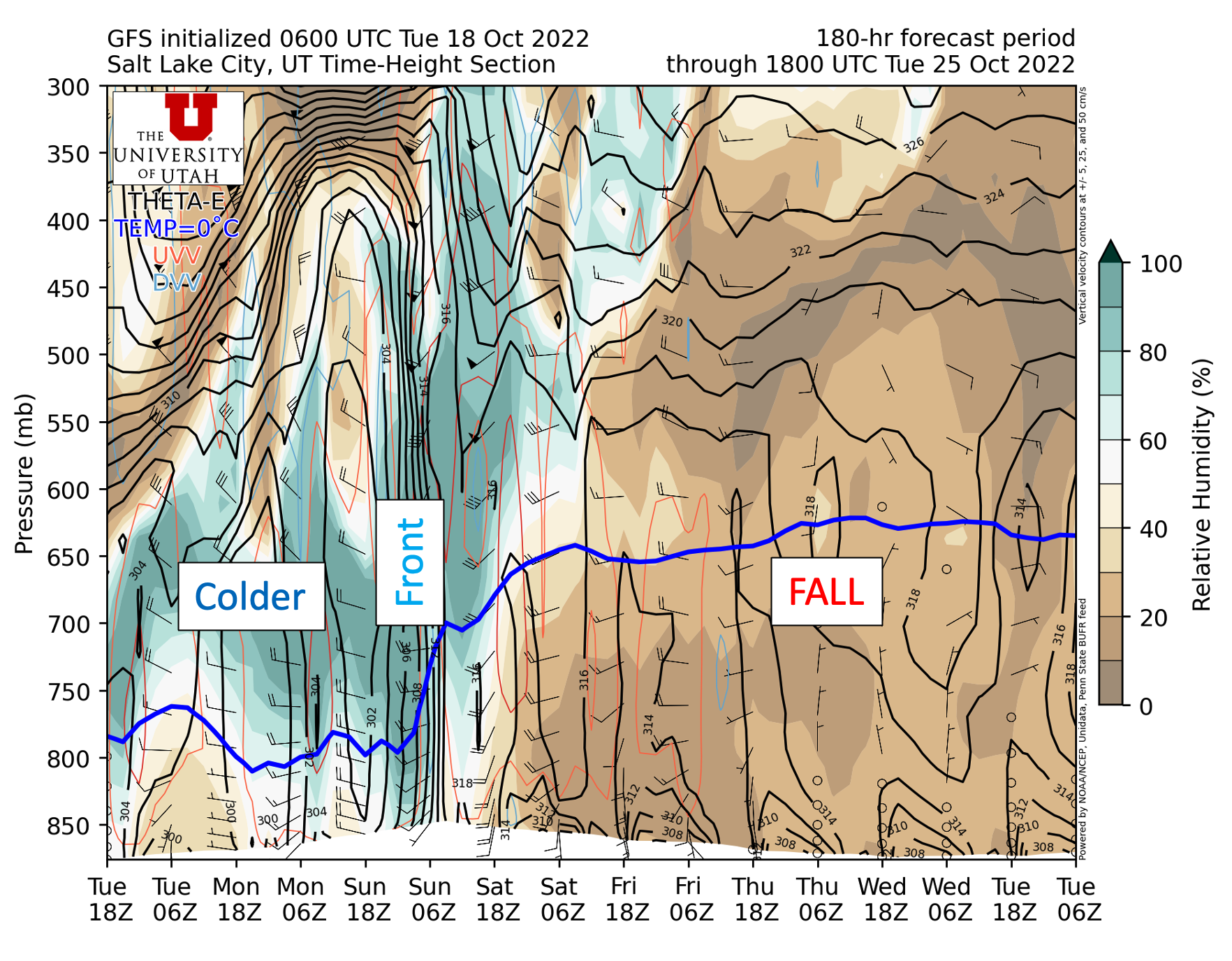
The GFS time height section shows very low humidities over Utah and wonderful fall weather through Friday morning (a reminder that time increases to the left in the plot below).  Some higher humidity air moves in aloft ahead of the front which may give us some high clouds on Friday.  Then the bottom drops out with the cold frontal passage, with freezing levels dropping to about 800 mb (7000 ft) and moist, northwesterly, post-frontal flow moving in.  

It's a little early to be discussing details for the storm, but it seems likely that we will see the first significant mountain snowstorm of the season.  The GFS generates about 1.6" of water at Alta-Collins through Monday and the downscaled NAEFS ensemble an average of just over 2"  However, the range remains large with low-end forecast around 0.5" of water and and high end over 4".  Much will depend on the trough characteristics and the post-frontal environment.  Most if not all of this precipitation will fall as snow at upper elevations.  

We'll see how things look in a few days.

Sunday, March 6, 2022

Avenues Snow Bomb

There aren't many days when the Avenues get the bragging rights for snowfall, but today is one of them.  

During the day yesterday, a frontal boundary developed over northern Utah, with the band especially strong along the I-80 corridor from the area near Stansbury Island to the Salt Lake City International Airport and the lower avenues.  Below is the radar imagery for 02:42 UTC (7:42 PM MST) illustrating the situation.  

Source: NCAR/RAL

A sounding collected at the airport at just before 0000 UTC (5 PM) showed shallow northerly flow associated with the front below about 725 mb, with southeasterly flow aloft.  

Source: SPC

Additionally, the sounding was very moist at low levels and near what meteorologists call moist neutral, meaning that the stability was weak to non-existent or even weakly unstable for moist flows (i.e., with a relative humidity of 100%).  Thunder was even reported in some parts of the Salt Lake Valley that afternoon.  

At about 6:30 we were getting takeout on 400 South where it was starting to rain hard with a little bit of melting snow at times.  We drove through the melting layer when we returned to our home at about 5000 ft elevation.  From that point on it was game on for the next 3.5 hours with heavy snowfall.  I took the photo below at 7:47 PM when perhaps two inches had accumulated.  

By 9:30 several inches had fallen.  A plow had finally gone up Virginia to 11th Avenue and I opted to drive my son and his girlfriend home near the U of U campus.  The drive was sporting, although the snow was deep enough that on the unplowed roads in the upper avenues braking wasn't a problem.  Just take your foot off the gas and let the car auger in.  

I got home at about 10 and made an unofficial measurement of about 10 inches on our front lawn.


We have an automated snow-depth sensor at the mouth of Red Butte Canyon on the University of Utah campus.  Snow depth increased 4.3" from 9–10 PM MST and 7.7" from 8-10 PM.  

Source: MesoWest

Those are impressive snowfall rates!

Meanwhile, in the central Wasatch, the Utah Avalanche Center reported 6.5" along the Park City Ridgeline, 8" in Big Cottonwood, and 6" in Little Cottonwood overnight.  What can I say?  Mother Nature isn't giving much love to our mountains this year.  

Snowfall totals through 10 AM this morning reported to the National Weather Service maxed at 14" in Salt Lake City (5088 ft) and the upper avenues (5000 ft).  I'm not sure where that Salt Lake City site is.  It could be in the avenues or the east bench above Foothill, but I'm going to say that Avenues were the big winners in this one.  Take that Alta!  Given that my ankle is still not allowing me to ski powder, the storm was greatly appreciated.

Thursday, December 9, 2021

I Love It When a Storm Comes Together


After fits and starts overnight with convective graupel showers, full-blown frontal precipitation has developed over northern Utah this morning and mountain snowfall rates have really gone through the roof.  Observations from Alta-Collins show .09" of water equivalent and less than an inch of snow through 5 AM, but since then, there's been 0.29" of water equivalent and about 4" of snow.  

Radar at 1433 UTC (0733 MST) shows pretty complete coverage over the northern part of the state.  There are a few holes of lighter precipitation, but for the most part, this is as good as it gets for complete coverage in this part of the world.  


In the upper aves, we were just starting to turn to snow at 7:15 AM with trace accumulations on colder surfaces.  This puts the snow level pretty much at 5,000 feet.  


When I got to campus, it was mainly rain with a few flakes mixed in.  

To the north, a look at UDOT cameras shows accumulating snow on cold surfaces in the Layton area.  We should see continued lowering of the snow levels this morning.

There's no real change in the forecast.  Snow, heavy at times today in the mountains.  Rain changing to snow in the valley.  The NWS Winter Storm Summary from 4 PM yesterday pretty much nails it still.  


Tonight and tomorrow morning, much depends on the post-frontal crap shoot.  

Beyond the ski resorts and upper-elevation backcountry, we are already seeing accumulations along I-80 near Mountain Dell.  


Keeping my fingers crossed that we can get a healthy accumulation there to open up the ski touring, assuming TUNA is ready to go.  

Friday, September 17, 2021

Keep an Eye to the Sky this Weekend

It's a somewhat surprisingly complicated weather forecast for the weekend, but not that atypical for September as we transition from the so-called monsoonal flow pattern to the cool-season westerly storm track. 

We'll begin with a look at the GFS forecast valid 0600 UTC 18 September (0000 MDT Saturday).  At this time, a deep upper-level trough (black contours) and frontal system are pushing onto the northwest coast.  Ahead of this system is a much weaker trough over California.  It doesn't look like much, but it contributes to a surge of monsoon moisture (color contours are precipitable water – a measure of the total atmospheric water vapor) into Utah (red arrow).  

As the deep upper level trough and cold front push into the Pacific Northwest, the weak trough slowly moves northeastward and the monsoon moisture streams into northern Utah.  By 1800 UTC 18 September (1200 MDT Saturday) the GFS is generating some scattered precipitation in northern Utah, mainly in a narrow region coincident with the monsoon surge. 


Thus, I would be aware of the threat of showers and thunderstorms tomorrow in northern Utah, especially from about noon through midnight.  These storms could be strong, as indicated by the NWS infographic below.  

Source: NWS, downloaded 8:35 AM MDT 17 Sep 2021

As indicated by that graphic, keep an eye to the sky and on forecasts and radar imagery if you have outdoor plans.  It's not possible to precisely predict the timing and distribution of these storms a day in advance.  

Your outdoor plans on Sunday should also consider the weather forecast as that is when the upper-level trough and the cold front arrive.  The timing of the surface front varies by a few hours amongst the various models.  The NAM brings it through the Salt Lake City International Airport after 6 PM MDT Sunday, whereas the GFS is much faster and brings it through just before 3 PM.  


The Euro also calls for frontal passage closer to 3 PM.  Based on this, I suspect the morning will be prefrontal, with the front coming through at some point in the afternoon.  Expect the temperatures to drop precipitously following the frontal passage and on Monday morning they will be around 20˚F at 11,000 feet.  

Although cold enough for snow in the higher elevations Sunday night, most of the model runs are favoring little to no snowfall at this time.  Below is the downscaled SREF for Alta-Collins as an example and of the 26 members, only 1 generates more than 2" of snow and the rest are 0.6" or less.  


  Still, I suspect the airmass, even in the valley, will definitely make it feel like fall on Monday.