Saturday, March 30, 2024

Winter Continues

It's a great pattern for late March with snowfall continuing today.  Overnight, Alta-Collins picked up 6 inches (as of 7 am) and the radar looks pretty filled in as I write this at 7:20 AM.

Snow today from 7 AM to 5 PM should add another 3-6" to the stake.  The HRRR says morning will be more active than afternoon, whereas the GFS keeps it going for most of the day.  Let's hope the latter verifies as that might push us above my forecast range.  

Periods of snow will continue through Sunday night, with perhaps some snow showers on Monday.  I'm not sure if it will stay cloudy and snowy enough on Monday to help preserve the snow, or if we will start to see the caustic effects of the sun.  After Monday though, warmth and sun return this great powder run will come to an end.

Wednesday, March 27, 2024

The Goods on Graupel

Ski conditions in the Wasatch backcountry continue to be excellent with cold weather and cloudy skies enabling pretty good snow preservation despite it being late March.


Over the past couple of days, a lot of the snow that has fallen has been in the form of graupel, which is an opaque, white snow pellet that sometimes takes a lump, hexagonal, or conical form. Graupel often causes the snow surface to have a dippin' dots appearance.  


Catch some on your sleeve and take a close look you'll find that graupel particles are aggregates of a bazillion tiny frozen cloud droplets.  


Graupel forms in strong updrafts when supercooled cloud droplets freeze on falling snowflakes.  Supercooled means that the cloud droplets are unfrozen, despite being colder than 0˚C.  These droplets freeze on contact.  This process is sometimes called riming or accretion.  If the riming is light, you can still distinguish the original snowflake.  However, at the extreme, the flake is completely coated and you get graupel.  

One of the reasons why we have had so much graupel the past few days is that it's been very unstable.  Graupel requires strong updrafts to suspect a snow crystal until it is fully rimed.  Snowflakes typically have a fall speed of about 1 meter per second.  Graupel is about 3 meters per second.  So, if you want big graupel, you typically need updrafts of at least 3 meters per second.  

Graupel is important for thunderstorm electrification.  In thunderstorm updrafts, smaller ice crystals are often carried upward by updrafts, whereas the larger graupel particles can fall out.  This contributes to the charge separation process within the cloud and in some cases lightning and thunder.  This happens even in summer thunderstorms, which extend well above the freezing level, although in those small hail can also form and be a contributor to electrification).  This has been happening some in Utah the past couple of days.  Snowbasin closed early yesterday due to lightning.  

People are often surprised by thundersnow, but the process is the same as in summer thunderstorms. It's just less common because you need strong updrafts and those are less common in many winter storms. Lake effect snowbelts see thundersnow more frequently because lake-effect storms often have strong updrafts.  In northern Utah, the daytime heating if post-frontal cold airmasses in the spring can also lead to strong updrafts and thundersnow.  

Because graupel is dense and has a higher fall speed, it can penetrate farther below the melting level than most snowflakes.  Thus, sometimes you see graupel falling at higher temperatures than snowflakes.  

Graupel should not be confused with sleet.  Sleet is a translucent ice pellet.  Unlike graupel, which is opaque and typically a bit pliable if you squeeze it, sleet is hard.  Sleet also forms through a different pathway.  Sleet forms when snow falls into a warm layer aloft with temperatures above 0˚C and melts into rain or droplets that are predominantly water with perhaps a small particle of ice in it.  It then falls into a colder layer near the surface that is below 0˚C and freezes.  

Sleet is basically a frozen raindrop.  Graupel is a snow particle formed by riming.  Very different processes.  Graupel skis much better than sleet.  You would definitely notice the difference.  Sleet is exceptionally rare in northern Utah (I'm not sure if I've ever seen it here). 

Enjoy the graupel skiing while it lasts. 

Monday, March 25, 2024

Just What the Doctor Ordered

The Saturday night frontal passage seemed to provide just what the doctor ordered for transitioning from spring skiing back to proper powder skiing.  I found good skiing yesterday with just a hint of bottom feeding at mid elevations if you kept the slope angles reasonable.  


Storm totals per the Alta-Collins site are now over two feet.  Elsewhere, a healthy lake band developed overnight, but raged over the western Salt Lake and Utah Valleys.  

It has since broken up some but scattered lake-effect snowshowers continue this morning, albeit a bit farther west than central Wasatch skiers would like. 


The unsettled post-frontal weather will continue through Tuesday evening.  Although not in the lake-effect now, expect periods of snow showers throughout this period in the Cottonwoods and perhaps even a thunderstorm or two in the afternoons.  For the period from 6 AM MDT this morning through 6 PM 12 AM MDT Wednesday March 27, the GFS produces .79" of water and 14.7" of snow at Alta.  The HRRR was less excited (.44"/7.6").  Regardless, it will come in fits and starts, which is my new phrase for the week.  It's great skiing for late March.  Hopefully the sun will not do too much damage when it appears at times.  

Enjoy.

Sunday, March 24, 2024

Storm Update

Pretty good delivery of the white in the upper Cottonwoods yesterday afternoon and last night. As of 6 AM, Alta-Collins is already at 13 inches with 1.32" of water.  That's a mean water content of 10%, although I suspect it's right side up.  We need some high density snow to bury the coral reef anyway.  All in all this is good news.  

Radar early this morning showed a fairly active northwesterly flow pattern.    

Expect periods of snow in the northwesterly flow to continue today.  The HRRR really lights it up with .66" of water and 11.1" of snow at Alta from 7 AM to 5 PM MDT today.  The GFS is not as excited puts out .19" of water and 3.6" of snow.  A big reason for this discrepancy is the HRRR really gets things going in the northwesterly flow, including some lake effect, as illustrated by the forecast radar image for 2000 UTC (2 PM) this afternoon.  


And for the 6-h period ending at 0000 UTC (6 PM MDT) the HRRR is generating 7.5" of snow for Alta and even higher amounts along the Alpine ridge to the west in the Lone Peak area.  

A real question is how much to buy into the HRRR forecast?  I'm inclined to expect another 4-8" at Alta-Collins for 7 AM this morning through 5 PM this afternoon, which sits between the GFS and HRRR.  I'd put the odds of going above that higher than below.  How bout we throw in the chance of a T-storm too?  Welcome to spring.

Saturday, March 23, 2024

Winter to Return

After about a week of splendid spring weather, winter will be returning to the Wasatch Range today with the arrival of a cold front this evening.  

Although there will be some periods of high-elevation snow and low elevation rain ahead of the front, the main action will be associated with the frontal passage which will bring a few hours of steady snowfall overnight.  

The cold-front is very apparent in the latest HRRR run with an abrupt drop in the wet-bulb zero height at between 7 and 8 PM.  


We base the wet-bulb zero level estimate on the model forecast from the airport (if we used data from Alta we would not be able to estimate snow level most of the winter since there's no data below ground), so expect that drop to be more like from 8-9 PM in Little Cottonwood.  Snow levels are usually a bit below the wet-bulb zero, so expect them to be in the area of 7000-7500 feet today, possibly higher in the afternoon with heating, and then drop to near bench levels after the frontal passage.  

The HRRR is calling for about 0.85" of water and 8.6" of snow at Alta Collins through 9 AM Sunday.  A bit less than half of this is high density snow that falls in fits and starts ahead of the front, including this afternoon, and the remainder is with the frontal passage.  Densities will be decreasing behind the front.  

The HRRR then shuts things down late tonight through tomorrow afternoon when things begin to pick up again.

The GFS is less enthused about the pre-frontal precipitation today but is in rough agreement on the frontal passage.  It's also a bit more active during the day tomorrow.  Through 9 AM Sunday it's at .55" of water and 7.6" of snow.  

So, expect some fits and starts of wet snow at upper elevations today and then steady snow with the frontal passage this evening and tonight.  I'm inclined to go close to the model water numbers on this with 0.5 to 1" of water and 6-10 inches of snow at upper elevations through 9 AM tomorrow.  

Given the warmth of the past week, I'm not overly optimistic that the frozen coral reef will be buried by tomorrow morning.  Things will need to go above those numbers probably to prevent a lot of bottom feeding.  If that doesn't happen, the better skiing tomorrow morning will probably be in lower angle terrain where the snow surface is currently fairly smooth.

That said, behind the front, unstable northwesterly flow looks to predominate through at least Tuesday and possibly Tuesday night.  The GFS time-height section shows this well.


Thus, expect more periods of snow Sunday through Tuesday, with the coral reef becoming more and more submerged and a return to more winter-like ski conditions in the upper Cottonwoods.

Wednesday, March 20, 2024

Beautiful Spring Weather

If you look carefully, you can see a couple of clouds in the Mt. Baldy web cam from Alta Ski Area this morning.

Source: Alta Ski Area

Those are not enough, however, to mar the incredible run of beautiful weather we have had since the demise of the easterlies on Saturday.  

Indeed, that run will continue today with clear skies and temperatures into the upper 60s in the valley.  If we can't have powder, this is a pretty good alternative.  

A weak short-wave trough will come through tomorrow and bring in a few more clouds and maybe a spritz of a shower or upper-elevation snow shower for the mountains tomorrow.  Significant weather will hold off until the weekend when a cold front is expected to push across northern Utah on Saturday.  Current forecasts suggest that the front will arrive in the afternoon.  Below is the ECMWF forecast valid 2100 UTC 23 March (3 PM MDT Saturday) with the front approaching Salt Lake City.


A real question mark for skiing will be whether or not that storm produces enough snow to bury the coral reef from the warm sunny weather this week.  We shall see.

I used the ECMWF above because I just upgraded the graphics produced for it on weather.utah.edu.  While I was in Austria, ECMWF opened up more of their data for free access.  We are now getting higher resolution data (0.25 degrees instead of 0.4 degrees), radiation fields that allow me to put together a synthetic cloud image (see upper right), vertical velocity (see upper left...smoothed to show the large-scale vertical motion), and additional wind and humidity information that allows me to better calculate integrated vapor transport (lower right).  

Sunday, March 17, 2024

Sastrugi

Along with graupel, sastrugi is one of my favorite weather-related words and I saw plenty of it ski touring yesterday.  

Sastrugi is defined by avalanche.org as "heavily wind eroded snow with wavy textures." Sometimes it looks rough or pockety.  In the photo below, it appears there is avalanche debris on this slope, but in reality it is all sastrugi.  

In some areas, the sastrugi was dense wind board and generally supportive of a skier. 

In others, it was actually somewhat soft and didn't ski to bad on the descent. Each turn was a mystery!

Although I like sastrugi as a word, it's not my favorite snow surface to ski.  We can blame the sastrugi in this case on the multiday easterly wind event that has been affecting the Wasatch Range and Front since Thursday.  Observations from Alta's Mt. Baldy show the winds veering (turning clockwise) from southwesterly just prior to 1200 MCT 12 March (Tuesday) to north by 0000 MDT 14 March and then locking in with easterly flow with gusts reaching over 50 mph on the 15th (Friday) when most of the damage was done. 

The large-scale setup for these winds was something that meteorologists call anticyclonic wave breaking in which a high-amplitude ridge develops in the high latitudes and leads to the formation of a closed low downstream and to the south.  Below is the GFS analysis for 1200 UTC 15 March during the period of stronger easterly flow on Mt. Baldy.  Note the ridge off the Pacific Northwest coast and the deep closed low centered along the CA-MX border, resulting in strong easterly 700-mb (crest-level) flow over the Wasatch. 


This is the same pattern that produced heavy snowfall along the Colorado Front Range. Basically, this is a complete reversal of the climatological westerlies.  They get upslope and we get downslope.  

The pattern has been very persistent and this morning enhanced easterlies ares still being observed along the east bench of the Salt Lake Valley north of Holladay, although they are weaker than at the peak.  

Friday, March 15, 2024

Austrian Misadventures, Part III

We will return to regularly scheduled programming soon, but I hope you will entertain one more additional post on our misadventures in Austria.

Ischgl

After skiing the Arlberg, we decided that we should get up early the next day and ski Ischgl.  We had put off skiing long enough and Erik seemed to be skiing decent on the pistes with his arm in a sling.  It's a bit of a haul to Ischgl on transit, so got up early, caught a 6:41 train to Landeck, and then a bus up the Paznaun valley to Ischgl, arriving at about 8:30 as the valley lifts opened.  

Ischgl is located in the next vavlley south from St. Anton, just 12-km away as the crow flies.  It receives a bit less snow since it is deeper in the inner Alps, but has two distinct advantages for skiing.  It has more high elevation terrain and it has predominantly northwest aspects.  Although not as spread out as St. Anton, it is a big resort, with a vertical drop of almost 5000 feet.  It is also known for a hedonistic night life and served as "ground zero" for the COVID spread through Europe, but we weren't going there to party.

We caught the Pardatschgratbahn S3 cable car which brought us from 1377 to 2600 meters and then started working our way southward.  In the southern portion of the resort you'll find the Gampenbahn six pack chairlift, which rises just over 3000 vertical feet and has the largest vertical rise of any six-passenger chairlift in the world.   

It also services pretty good terrain, especially on its upper half.  I no longer have the legs to do this, but I've often wondered how much vertical you could rack up on a chair like this.  

To the south past the Gampenbahn, there is a lot of open terrain and only one lift, the Piz Val Gronda cable car.


The 150 passenger aerial tram services an enormous amount of freeride terrain, although some of it is flat or lower angle.  There is only one piste.  There is no restaurant at the top.  I like to call it the cable car to nowhere.  I have heard that it's construction was controversial since it covered terrain that was otherwise undeveloped or at least underdeveloped.  

We then worked our way back to the north and eventually across the main Ischgl ridge.  Crossing this ridge puts you in Switzerland and the Samnaun ski resort. The two are interconnected and served by one pass.  Samnaun also provides almost 5000 vertical feet of relief.  We lacked the time to ski to the bottom, but did ski the upper part of the resort and skied down into the Mülbach valley for lunch.

We weren't disappointed. 


One rarely is disappointed when it comes to food in the Alps.  

After skiing back over the Ischgl, we spent a little time skiing under the Pardatschgratbahn S3 cable car.  I have skied at Ischgl three times, and each time, the #4 piste offered up uncrowded cruising.    

We descended down to Ischgl and walked about a half a kilometer to the first bus stop before town.  This is a good rule to follow if you want a seat on busy days.  

Artzler Alm

After skiing Ischgl, we had only one day left in Innsbruck.  We decided not to push our luck with more skiing. We also needed to pack, which was not a trivial matter given that we had brought touring and alpine gear.  

We decided to take advantage of the mild valley weather and go for a hike to Artzler Alm, a lower elevation mountain hut just north of Innsbruck.  It was their first day open for the season and we were amongst their first customers.  


I'm a big fan of hiking to these huts where I like to enjoy a johannisbeere gespritzt (sparking water flavored with black currants), and either lunch, cake, or strudel.  

And the views are very enjoyable.  Note the structural defenses for avalanches on the left in the photo. This is near the bottom of a long-running path that has penetrated into the upper reaches of residential areas near Innsbruck.

If you ever visit Innsbruck, consider a hike to one of the great mountain huts above town.  At lower elevations, you'll find Umbrugler Alm, Artzler Alm, and Rumer Alm.  Higher up Bodenstein Alm and Höttenger Alm.  None of these will disappoint.  You can do some nice loops if you hook up with the Seegrube cable car.  

Munich

Our trip concluded the next day with pigs knuckle in Munich.

Wednesday, March 13, 2024

Austrian Misadventures, Part II

Previously on Wasatch Weather Weenies, the ski plans of my son and I in Austria were marred by a dislocated shoulder and we began to travel around Tyrol and environs using Innsbruck as a base.    

After going to Sölden (see Austrian Misadventures, Part I) where I was able to do some skiing, the weather deteriorated and we elected to shift back to more traditional sightseeing for a couple of days.

Salzburg and Innsbruck

My son had never been to Salzburg, so we grabbed an early morning train, consumed pastries on the way, and went for a visit.  On one of the OBB railjet trains, that reach speeds of up to about 145 miles per hour, it's less than a 2 hour trip (one doesn't go that fast the whole way, but it's nice to fly along in sections).  Many people who visit Salzburg do the Sound of Music tour.  I have been to Salzburg several times and am proud to say that I've yet to do it.  Instead, we visited the Hohensalzburg Fortress, a medieval monster that sits on a hill above town.  

Construction on the fortress began in 1077 with various additions over the years.  It must have been imposing back in the day (it still is) and quite a seat of power.  We enjoyed a bit of time walking through town and visiting a few other sights like the Mirabell Palace gardens, which were just starting to wake up from their winter slumber.

After four days with a good deal of travel, we then spent a day in Innsbruck.  I attended a seminar in the Department of Atmospheric and Cryospheric Sciences and we had dinner with several friends from the Department. 

This was also the day when Erik said that he wanted to go skiing, even if it was in a sling and sticking to pistes.  

I confess I had some trepidation about Erik skiing.  I didn't want to see him fall on that shoulder again.  On the other hand, it costs almost as much to buy a pedestrian pass to ride a cable car once as it does to buy a lift ticket.  Why not ski conservatively and make a day of it?  

Ski Arlberg

The next morning we traveled to St. Anton to give Erik the experience of village to village skiing in the Alps.  St. Anton is part of the largest interconnected ski area in Austria, known as Ski Arlberg or simply The Arlberg.  The Arlberg is one of the snowier locations in the Alps and it is possible to ski, without using anything but lifts, through several villages including St. Anton, St. Christoph, Stuben, Zürs, Lech, Warth, and Schröcken, which are located in the Stanzer, Klöster, Lech, and Krumbach Valleys.  

Ski Arlberg is also one of the busiest ski areas in the Alps, so this is industrial-scale skiing on everything from cable cars to t-bars.  In some areas, a small number of pistes (sometimes one) are serviced by one or more high-capacity lifts, and on-piste skier density is terrifyingly high. This added to my trepidation.

To get to St. Anton, we took the train from Innsbruck.  You are there in about an hour and 10 minutes.  The train station sits right on the edge of the village, about a five minute walk from the lifts (photo below actually from our departure that afternoon).  Talk about convenience!

For our first run, we took an easy run from the top of the Galzigbahn cable car down to the village of St. Christoph on the Arlberg pass.  The trail wasn't crowded, so this was a good situation for Erik to get used to the sling and one-pole skiing.  Clouds were still lingering over the Arlberg pass, but blue skies prevailed to the west where we were heading.  

After riding two chairlifts, we then had to do one of the most terrifying descents of the day from the Ulmer Hütte down the one groomed piste in the Valfagehrbach valley to the Flexenbahn cable car near Stuben.  It's a beautiful descent. 

However, it is the only groomed piste to connect from St. Anton to Stuben and it is quite crowded (I had nightmares of skiing this run from when I lived in Innsbruck in 2019).  Further, on the day we were there, a few cm of fresh snow sat on top of a rock hard melt-freeze crust, which quickly resulted in a hard ice/soft mogul situation that tortured the many skiers of limited abilities.  We slowly picked our way down this to ensure no surprise collisions.

What a relief to get down.  We then rode the flexenbahn cable car and skied down to Zürs, pictured in the valley to the right in the photo below (to the left is the Klöster valley). 


We did some skiing in the Zürs area before ascending the Madlochbahn to ski down to Zug.  The descent to Zug is long and quite spectacular.  I've had my eye on some of the freeride terrain in this area since I first skied this route in 2019, but alas it would need to wait for another day.  


We stuck to the pistes as we descended to Zug with views of Lech and the Lech Valley. 


Eventually we found our way to Lech.  Under normal circumstances, I suspect we would have already gotten to Warth at the northern end of Ski Arlberg, but we were skiing cautiously and puttering along and decided to head back to St. Anton from after pounding a schnitzel semmel at the local grocery store. 

Lech

The section from Lech back to Zürs is one of my favorites, not because the skiing is great (it's pretty low angle), but because the views are so spectacular.  From Lech, one rides the Rüfikopfbahn about 3000 vertical feet to a high shelf above Zürs.  You just meander on beginner runs along his shelf, gaping at the surrounding scenery.  


Eventually one reaches the Trittalpbahn chairlift and rides it to gain a bit more vertical before descending to Zürs.  From here, you ascend one gondola and then descend another to get back to near Stuben (there are no marked descent routes to get back down to near Stuben).  

There's still one more lift to go, the Valfagehr to near Ulmer Hütte from where you can descend all the way back to St. Anton.  But on such a nice day, there is another option, and that is to catch the Schlepp Lift and then ski down to the Vallugabahn I cable car and take it up to 2600 meters.  From here, you can take a small, 6 passenger cable car to the top of the Valluga and gape at the Arlberg.  No skis are allowed (without guide) on the latter, so it's purely a scenic ride. 


After riding back down the small cable car, you can finally ski down to a T-bar, ride it back up a few hundred vertical feet, and then do the very long descent to St. Anton.  We did this late in the day with hoards of other skiers also trying to get back to St. Anton, resulting in our second terrifying descent of the day.  In this case, not only was the trail packed, but half of the skiers are also inebriated.  Eastern skiers will recognize the "loose and frozen granular" snow condition.  


St. Anton is famous for après and the run back to town eventually takes you past some of the more popular bars including the Sennhütte, Heustadl, and Mooserwirt. 


Our circuit covered 18 runs, 39 km, and 7750 meters of vertical.  It was a pretty good day given the limitations (missing in the route below is the initial ride up the Galzigbahn from St. Anton). 


St. Anton's full "Run of Fame", advertised as the longest ski cruicuit in the Alps, allegedly covers 85 km and 18,000 m of vertical.  We skipped Rendl (south of St. Anton), Stuben, and the extension up to Warth and Schröcken. That will need to wait for two arms.  I suspect if I were ever to attempt it, I'd rather start in Zürs (probably bussing from the train station) as St. Anton is a much larger village and it produces quite a pulse of skiers all attempting the same circuit.  Alternatively, we could do what one of my Austrian friend recommends and that is to forget the Run of Fame and focus on good terrain.  That's probably good advice.

We didn't linger in St. Anton for après.  Instead, caught the train back to Innsbruck because we were thinking about getting some sleep, getting up early, and going to another mega resort.  That will be the subject of part III.

Tuesday, March 12, 2024

Austrian Misadventures, Part I

 "Plans are worthless, but planning is everything"
- Dwight D. Eisenhower

For the past few years, my son and I have been trying to find a time when our schedules align for a father/son trip that my mother suggested we do after my father and his grandfather passed away.  Pandemic, school, work, and life made finding a block of time difficult for many years.  

It appeared, however, we could pull something off this winter over my spring break, so in early January we booked a trip to Austria so that I could give him a proper introduction to backcountry and resort skiing in Tyrol and environs.  

We spent a lot of time trying to figure out where to stay, where to ski, etc.  Ultimately we settled on staying the entire trip in Innsbruck since it is easy to use transit to travel to any number of resorts or touring areas from Bavaria to the north to South Tyrol to the south and from St. Anton to the west to Kitzbuhel in the east.  In addition, I have a number of friends in the Innsbruck area, so we would have some local skiing and dining partners.  

At least that was the plan.  

Our first day in Innsbruck dawned with cloudy skies and some fits and starts of valley rain and mountain snow.  We decided to take an easy ski tour up Axamer Lizum, a local resort, and enjoy the culinary delights at the top.  This turned out to be a good call as the visibility was pretty much nil at upper elevations, so it would have been a waste to buy a lift ticket and ski touring outside the confines of a resort would have been terrifying.

Plus, we did find the culinary delights at the top.

After enjoying a proper lunch, we began to ski down.  We were traveling slowly down a groomer given the visibility when all of a sudden I saw my son take a hard, awkward fall.  I'm not sure if he hit a grooming rut or what, but I haven't seen him fall in years and I got a pit in my stomach.  He was in a lot of pain and said he felt his arm come out of the socket and go back in.  The pit got deeper.  

After giving him a few minutes, he decided to ski down to the bottom, which we did.  We then got on the bus back to Innsbruck.  While riding back to town, the arm came painfully out again.  I called a friend in Innsbruck who met us at the hospital where the dislocated shoulder diagnosis was confirmed and he was fitted for a sling.

Ski trip over, or so we thought.  

That night, although in shock, we started making a list of things we could do.  Staying in Innsbruck turned out to be very fortuitous since it is so easy to access transit from the main train station only a 5 minute walk from our rented flat.  

The next morning, we bought week long transit passes covering all rail and bus transit in Tyrol and some areas of Bavaria and South Tirol for $46.50 euros each.  We were off.

Mittenwald

That first post-crash day we took the train from Innsbruck to Mittenwald, just across the border in Germany.  There was a cable car there that I've been oogling since first seeing it in 2015.  Part of the attraction is simply to answer the question, why would anyone ever build a cable car up that mountain?  

It rises 4300 vertical feet.  There's no ski area at the top. However, there is a brewery and with a short winter walk with limited avalanche hazard, you can get a great view of the Karwendel Alps.

If you are so inclined, there is also a 400-meter long tunnel that they have carved through rock that will take you to an area you can ski tour.  

All and all a fun day.

Hahnenkamm

The next day we took the train to Kitzbuhel.  I figured if Erik couldn't ski the Streif, he could at least see it.  Turns out it wasn't skiable from top to bottom anyway.  Kitzbuhel is quite low and recent warmth had decimated the snow.  The "traverse" was closed and there was no natural snow at the bottom. 

We bought a pedestrian pass for the Hahnenkamm cable car, did a short hike at the top (there's some winter hiking that can be done up there, although I'd rather ski), and looked at the start house for the famed downhill.  
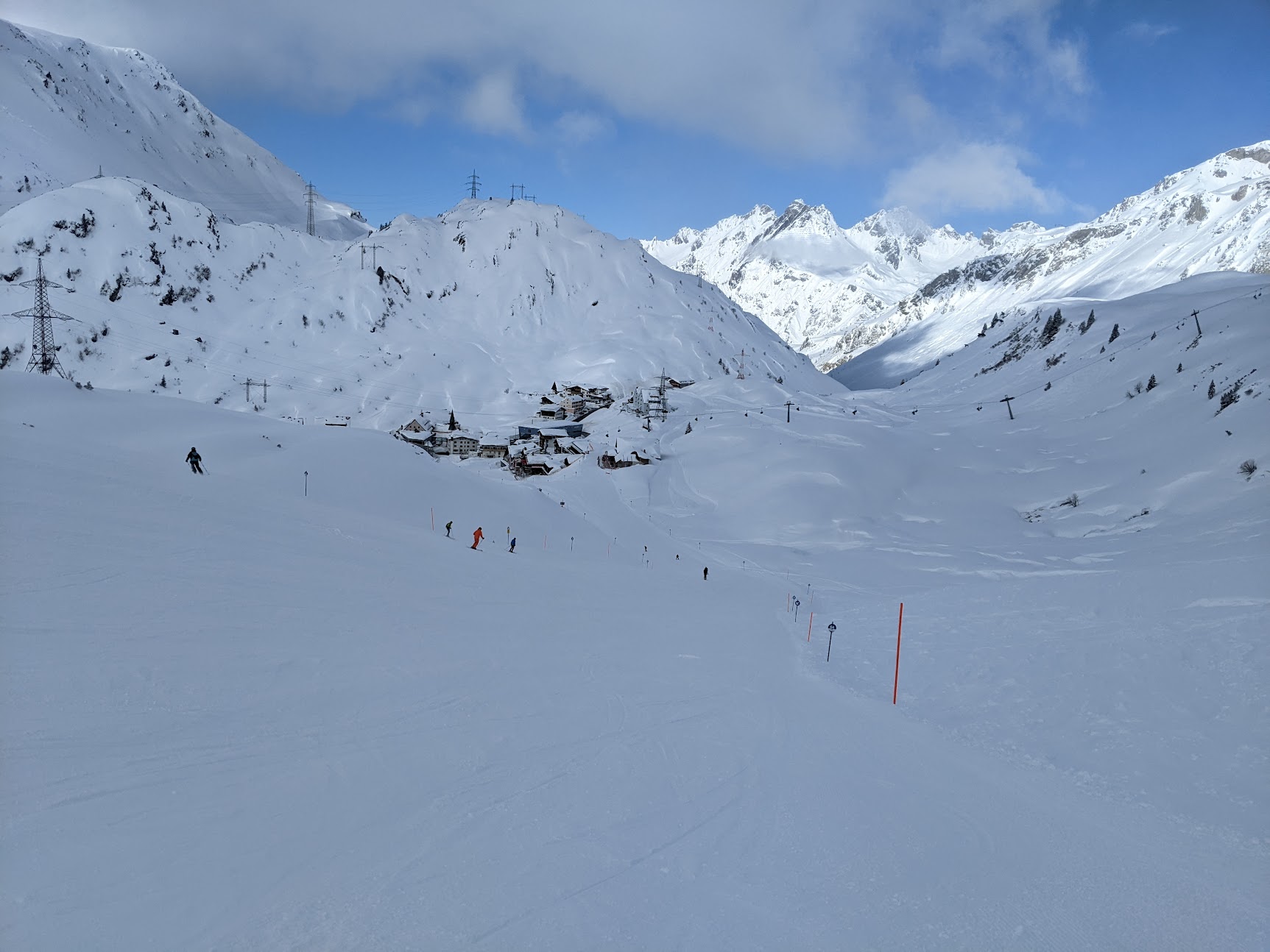

Sölden

That evening a friend in Innsbruck said we should go with him to Sölden tomorrow, so we did.  I went skiing while Erik rode cable cars there and in nearby Obergurgl.  Below is a photo from the Gaislachkogl at Sölden, which is just above 3000 meters.  


I'd never skied Sölden previously.  It has enormous relief, covering more than 6,000 vertical feet, high altitude glaciers, etc.  There's a lot of lower-angle skiing there, but also some great freeride terrain.


I took the longest run of my life to finish the day, covering more than 6000 vertical feet from the top of the Schwartze Schneid gondola, down the valley below to the base.  


Much of it was lower angle, and the final descent into Sölden was a mushy, terrifying white ribbon of death, but a PR is a PR.


So, my ski trip wasn't really over, but my son's?  We'll talk about that in a future post.