
Pretty good delivery of the white in the upper Cottonwoods yesterday afternoon and last night. As of 6 AM, Alta-Collins is already at 13 inches with 1.32" of water. That's a mean water content of 10%, although I suspect it's right side up. We need some high density snow to bury the coral reef anyway. All in all this is good news.
Radar early this morning showed a fairly active northwesterly flow pattern.

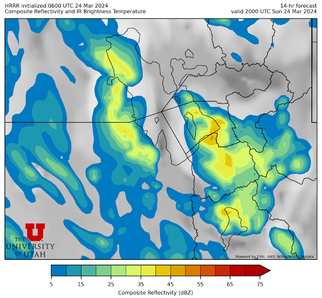
Expect periods of snow in the northwesterly flow to continue today. The HRRR really lights it up with .66" of water and 11.1" of snow at Alta from 7 AM to 5 PM MDT today. The GFS is not as excited puts out .19" of water and 3.6" of snow. A big reason for this discrepancy is the HRRR really gets things going in the northwesterly flow, including some lake effect, as illustrated by the forecast radar image for 2000 UTC (2 PM) this afternoon.
And for the 6-h period ending at 0000 UTC (6 PM MDT) the HRRR is generating 7.5" of snow for Alta and even higher amounts along the Alpine ridge to the west in the Lone Peak area.

Not sure if it was colder than expected last night/early this morning, but the snow at Brighton today was absolutely blower pow — like choke your mouth and nose with every slash blower.
ReplyDeleteWas expecting a bit of heavy spring cement and was pleasantly surprised. Probably the best day of riding I've had all year.
Yeah conditions were quite good in the BC if you didn't push the slope angles too much as those were sluffing off.
ReplyDelete