Showing posts with label Air quality. Show all posts

Wednesday, August 5, 2026

Escaping Smoke is Hard

During winter, the Salt Lake Valley often sees pollution episodes with elevated particulate matter due to the presence of low-elevation cold pools that persist due to the limited solar heating.  This enables particulate matter that forms from the emissions from automobiles, industry, home heating, and other sources build up within the cold pools, resulting in poor air quality.  This poor air quality is reflected in elevated levels of particulate matter with a diameter of 2.5 micrometers or less, or PM2.5.  Such events are known colloquially as inversions.

Because the PM2.5 is typically trapped in the cold pool, one can usually find clean air by moving to higher elevations.  The depth of the pollution varies from event to event and sometimes from hour to hour as the cold pool sloshes around in the valley.  At times, the benches may be in the clear air.  At other times, elevated PM2.5 can extend higher.  

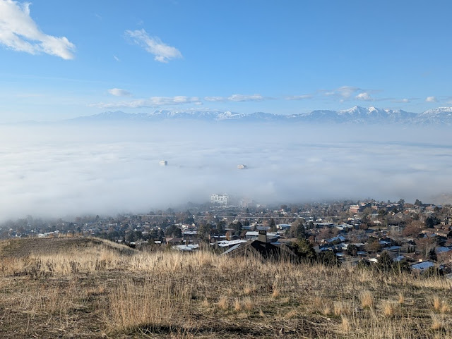
An example, from December 15, 2025, is shown below.  Taken from about 6000 feet in the Avenues foothills, one can very clearly see the layer of pollution within the valley, but clear air at upper elevations.  


PM2.5 associated with wildfire smoke in the summer is more complicated for a number of reasons.  First, the heat and intense vertical motions associated with wildfires can inject wildfire smoke anywhere from the surface to more than 15 km.  Because the wind often varies in strength and direction with height, the transport of that wildfire smoke can also vary in direction.  As an example, note how smoke from the Grasshopper Fire in northern Oregon spread in two different directions yesterday morning. 

Source: College of DuPage

As a result, smoke can be found even at the highest elevations and PM2.5 concentrations do not necessarily decrease with height.  Sometimes they can even increase with height.  

I had planned to hike up Snowbird this morning, but thought this might not be a good idea after looking out the window and taking a look at the PM2.5 estimates from Purple Air.  Unlike in winter, elevated PM2.5 wasn't confined to the Salt Lake Valley.  One could find values > 35 ug/m3 (i.e., unhealthy for sensitive groups) even at some locations in the Snyderville Basin.  Although there are fewer upper-elevation sits, at 8:57 AM MDT the highest PM2.5 was actually near the mouth of Little Cottonwood (53-68 ug/m3), Red Pine Lodge at Canyons (83 ug/m3), and Silverfork in Big Cottonwood Canyon (61 ug/m3).   

Source: Purple Air

It's hard to say if the top of the tram would have been above the smoke. The 9 AM webcam suggested it was close, but smoke clearly enveloped the terrain to high elevations.   

Source Snowbird

I ended up going for a less strenuous walk in the Avenues foothills.  Although the PM was still elevated, my back likes having the kinks worked out. Visually inferring PM2.5 concentrations can be tricky for a number of reasons, but the view toward the Oquirrhs seemed to confirm that this morning concentrations may have been higher above the valley floor as one could see the base of the Oquirrhs (red arrow) but not the mid or upper elevations (blue arrow).  This doesn't mean the valley floor had low PM2.5 values, but just that they appeared to be lower than at mid elevations.  


The National Weather Service has a modeling system to predict wildfire emissions and smoke transport and concentrations known as HRRR smoke. Its analysis for 1300 UTC (0700 MDT) this morning actually showed higher concentrations in upper elevation areas (e.g., Stansbury, Oquirrh, and Wasatch Ranges) compared to the intervening valleys. Although concentrations were lower than observed, it at least had the right idea. 


The HRRR smoke forecasts suggests perhaps some improvement later today and tonight.  We will see if that pans out.  Smoke forecasts are tricky.  

Note that the situation this morning with lower PM2.5 in the valley cannot be generalized to all wildfire situations.  There are times when PM2.5 concentrations from smoke can be higher at lower elevations.  Escaping wildfire smoke requires more investigation (and maybe a bit of luck).  The HRRR smoke forecast can be helpful.  I like to access them at https://sites.gsl.noaa.gov/desi. Select "HRRR-CONUS" as the dataset, an appropriate runtime (those starting at 0, 6, 12, or 18Z will extend out 48 hours whereas the other go to 18 hours but are more recent), and then "surface smoke" from the surface drop down menu at top. 

Saturday, January 17, 2026

Evidence of Top Down Mixing

The pollution layer over the Salt Lake Valley remains today (Saturday) but clearly shallowed over the past few days.

The photo below was taken at 0743 MST Tuesday.


 You can compare that with the one below taken at 0745 this morning.

So, some temporary relief in some upper-bench areas.  

On the valley floor, there was also some improvement, with PM2.5 this morning at Rose Park being lower than it has been in a few days.


All of this is evidence of top-down mixing with the pollution being mixed out from the top down.  Sadly, it has not all been removed on the valley floor. 

What remains after today we will probably be stuck with again for a while.

Friday, January 16, 2026

Stirred Not Shaken

As discussed in the previous post, a weak upper-level trough was expected to move over northern Utah yesterday, but it was unclear if it would crack the inversion (I was skeptical).  Indeed, looking at things this morning, I'll call it "stirred not shaken." Impacts on the pollution are varied.  In the Avenues foothills, there was clear improvement and evidence that the pollution is shallower, as sometimes happens in a weak partial mixout event in which things are eroded from the top down.  


On the other hand, a look at satellite imagery shows evidence of fog or low clouds in portions of the Salt Lake Valley, Tooele Valley, and the area from Bountiful to Layton.  Instead of being bright like the mountain snow, the fog and low clouds look grey, which may reflect that it is thin, patchy, or simply mixed with all of the smog that is still stuck on the valley floor. 

Source: College of DuPage.  Image from 1611 UTC/0911 MST 16 Jan 2026.

As I worked on this post this morning, some of these low clouds moved over campus.  

Air quality during this episode has varied considerably during the day.  At Hawthorn Elementary, one can see the PM2.5 levels peaking each afternoon.  Peak values worsen each day through the 14th (Wednesday).  There was slight improvement yesterday.  

Source: MesoWest

At Rose Park, one sees this same behavior, but peak values are somewhat higher and the nighttime declines are not as large. PM2.5 concentrations this morning are just a smidge lower than the previous two days.  

Source: MesoWest

The question now is what will happen this afternoon.  Temperatures this morning are actually several degrees C cooler above the valley floor than they were yesterday.  At about 7000 ft elevation, for example, it's 1.8°C this morning, whereas it was 5.0°C yesterday.  Thus, the inversion is weaker.  This makes it more susceptible to surface heating during the day.  One possibility is that with a bit of surface heating we start to vent the valley floor and we mix out some of the gunk.  A best case scenario is we vent everything.  I think that's unlikely, although perhaps some areas see some improvement.  

Perhaps more likely is that the pollution remains very stingy over and near the Great Salt Lake.  The lake is a bit colder than the surrounding land surface in situations like this and there can be a lens of cold, polluted air that remains entrenched over it.  That cold and polluted air tends to move into the Salt Lake Valley during the day.  Sometimes it mixes out for a bit only to have the polluted lake air push in during the day.  

We will see how this pans out.  Definitely a tough forecast.  Hope for a full mix out.

Tuesday, January 13, 2026

We Could Be Screwed

Just another day in the paradise that is the Wasatch Front.  The latest west-facing image from the University of Utah shows a blanket of smog over downtown Salt Lake City.  

Source: https://horel.chpc.utah.edu/camera_pages/wbbw.html

It's tough to get above it without going to the mid elevations.  I hiked this morning to the top of the Avenues foothills and it was unclear if I was completely out of it even at 5700 feet.  


Recent station (filled squares) and mobile (filled circles) PM2.5 observations show values in the valley generally between about 28 and 45 ug/m3.  

Source: https://utahaq.chpc.utah.edu/

The threshold for unhealthy for sensitive groups is 35.5 ug/m3, so we are seeing values that are near or above that.  The DAQ sensor at Hawthorne Elementary is at 41.3 ug/m3 as of 2 PM.  

Is there hope for a mix out?  The best chance is probably on Thursday and Friday.  On Thursday there is a weak upper-level trough moving over Utah late in the day in the ECMWF HRES forecast.


In the wake of that system, the northerly flow increases and crest-level temperatures drop to perhaps -2°C.  Perhaps the cooling aloft combined with the increased flow can at least give us a partial mix out, but other models are less optimistic than the Euro and it's possible we're screwed.  The GFS forecast for Friday afternoon, for example, still has a capping inversion based at about 825 mb.  In that case, we probably remain exiled in hell.  

Assuming we don't or only partially mix out, we could see the development of fog and eventually stratus that's elevated above the valley floor.  That will make for even more depressing conditions, but in some of those situations cloud base raises with time and produces a deeper mixed layer at low levels.  There's still pollution, but there's a bit more dilution that helps to moderate the PM2.5 levels (although they can still be hazardous).  

Hope for that partial mixout on Thursday and Friday.  

Monday, December 15, 2025

Building a Valley Cold Pool the Hard Way

If you want to build a persistent valley cold pool in northern Utah, often referred to colloquially as "an inversion," the best way to do it is to have a strong cold surge followed by the development of an upper-level ridge. The cold surge provides the cold air at low levels while the ridge then increases the temperatures aloft.  During the winter, there's insufficient heating from the sun to warm the cold air at low levels, so one ends up with a persistent valley cold pool that is topped by a stable layer or inversion that prevents the dispersion of air pollution. This process is even more effective if there is snow on the ground.  

The past two weeks, however, provided something a little different.  On December 6 we had an atmospheric river move through the area (indicated by green below...note that the meteograms for temperature and wind do not quite line up vertically).  This was followed by a period with occasional mid and high clouds, somewhat enhanced southerly flow, and rising temperatures.  At the Salt Lake City airport, the afternoon wind often switches to northerly or northwest, but those periods were pretty limited due to the enhanced southerlies.  The southerlies were not strong, but combined with a lack of snow cover and occasional clouds, they allowed us to remain relatively mixed and mild in the valley.  

Source: MesoWest

However, things changed after about December 11.  The flow weakened.  We also saw clearer skies.  The result was the slow development of a valley cold pool with temperatures falling each day.  On the 11th, the maximum temperature at the Salt Lake Airport was 62°F.  Yesterday it was 49°F.  

In contrast, if we look at the temperatures on Hidden Peak at the top of Snowbird (11,000 ft), they show a general warming trend for the period.  

Source: MesoWest

Essentially, we are building a persistent valley cold pool the hard way, without a prior cold-air surge. The ridge is building in, increasing temperatures aloft, but instead of having cold air at low levels to start, we were relatively mild.  Since December 11, however, with the flow weakening and less cloud cover, we are seeing temperatures declining with a valley cold pool slowly strengthening.  Yesterday afternoon we had a bonafide inversion with a surface temperature at the airport of 45°F and a temperature at 7200 feet of 50°F,

Source: SPC

And with the strengthening cold pool and inversion, we are starting to see the buildup of pollution in the valley, as evident from the photo I took yesterday at the top of Mt. Van Cott above the University of Utah campus showing smog in the Salt Lake Valley.


Really we're fortunate not to have had that prior cold surge or snow on the valley floor.  We're also fortunate to have a cold front coming in on Wednesday that will mix out the pollution.  

Note: We are moving into a more active pattern this week, but will be taking a break from blogging for a few days.  Good luck!

Monday, January 20, 2025

A Rare January Great Salt Lake Dust Event

The sun had not yet crested the Wasatch this morning when I awoke and when I looked out the window I saw this odd band of white extending at low levels through the western Salt Lake Valley.  

My first thought was what the hell is that.  It's too shallow to be a lake band and it doesn't look like fog.  I took a look at the weather observations and the relative humidity in that area was less than 60%.  What could it be. 

I then looked at PurpleAir thinking it might be dust, but even then the PM2.5 numbers didn't seem very impressive.  

I kept digging, soliciting the input of some meteorological friends.  Eventually, with some help of specialized observing sites, satellite imagery, and weather cams, it became clear that it was blowing dust originating from the exposed Great Salt Lake bed east of Antelope Island.  

A quick look at the evidence.  The most damning was a video of web cam images from the MesoWest web cam at Syracuse near the eastern end of the Antelope Island Causeway.  The view toward the southwest and Antelope Island clearly showed lofting dust in the northerly flow. 

Dust is sometimes hard to see in visible satellite imagery, but an increasing sun angle clearly showed dust pouring off the Farmington Bay area southward into the Salt Lake Valley with a well-defined plume over the central valley.  If you look carefully, you can see evidence of the plume over Utah Lake too.  


My colleagues in the Department of Atmospheric Sciences operate a study site on the Farmington Bay playa abut 7 km south of the causeway entrance.  It might be a bit upstream and east of the biggest dust emissions sources, but it has clearly shown some significant spikes in PM2.5 concentrations.  


I took a look at the PurpleAir data, however, and it didn't show much.  This was a bit of a headscratcher for me. The image below was grabbed at 12:06 PM and for the most part, it looks like good air quality. That was what I observed most of the morning.


However, the University of Utah and DAQ sensors told a different story.  The data below is from a bit before noon and those sensors showed areas with moderate air quality due to elevated PM2.5. At just before noon, the highest values were around 24 ug/m3 near and just north of Murray.  

I'm a fan of Purple Air, but there are sometimes absolute errors in their estimates and this seems to be such a case.  

Overall, this is a remarkable event.  I cannot recall such a strong, well defined, and long-lived dust emission event from the exposed lake bed of the Great Salt Lake in the month of January.  It took me a while after seeing the plume to convince myself it was happening, but it's hard to deny at this point.  It raises a lot of questions about dust emissions processes on the playa during winter.  I don't have a sufficient background in soil physics to speculate about what might be happening.  

Monday, December 9, 2024

Views of a Highly Stratified Atmosphere

During the most recent inversion event, fog developed over the Great Salt Lake, eventually expanding to cover most of the lake and environs.  Below is a series of images from the NASA Terra satellite, which flys over roughly mid morning on December 4th, 6th, and 8th, the latter being yesterday (Sunday).  

It was on the 4th that fog first became evident, with a couple of regions of fog extending westward from near Antelope Island over the southern bay of the lake.


By the 6th, fog covered most of the lake.  


And finally, by yesterday (Sunday, 8 December), the lake was nearly entirely covered and spread into populated areas that included the northern Salt Lake Valley and portions of Davis County.  


Given the limited lowland snow cover in this instance, it is likely that the evaporation of water from the lake played an essential role in fog formation in this event, leading to fog development and persistence mainly over and near the lake.

I often tell students not to conflate the inversion with the pollution or the fog layer.  In part, this is because the stratified nature of the atmosphere during inversion events is such that neither the fog nor the pollution are perfectly colocated with the inversion.  Instead they are embedded in it or trapped beneath it.  The former was the case yesterday.

Temperatures in the morning sounding from the airport yesterday increased with height from the surface to 817 mb, or 6010 feet.  

Source: SPC

However, the fog was much shallower than that.  In fact, one was above it at about 5200 feet elevation in the Avenues foothills.


And at times the LDS office building and other tall buildings downtown rose above it.  


There was also evidence of pollution above the fog layer.  This might be inferred from the photos above but is better illustrated by one taken towards the sun and University of Utah.  In it you can see the fog, as well as complex layering of aerosols (i.e., pollution) in the atmosphere.

During inversion events, the atmosphere is often highly stable and "inverted" through a layer that is much deeper than either the fog or pollution layer.  Emissions and the transport of pollution by atmospheric flows and turbulence often occur within or beneath the inversion.  In these instances, the atmosphere is often quite stable (and often "inverted") even above the fog or pollution.  Variations in the timing and location of emissions, and the transport of them by atmospheric flows and turbulence, yield layers of "haze".  Natural emissions of water vapor from the lake are also trapped at low levels, resulting in fog formation over and near the lake, but not necessarily through the same depth as the pollution.  

In this most recent event, we ended up with a highly stratified atmosphere with fog and pollution layers.  

Thankfully, we had something to drive more mixing in the atmosphere yesteday and last night, and that was increasing flow and the decrease of temperatures aloft which were associated with an approaching trough.  Ultimately this mixed out the atmosphere, to everyone's great relief.  

Breathe easy.

Wednesday, December 4, 2024

Intricacies of this Inversion

We are currently mired in the first major inversion and air quality episode of the season, although I don't think it's been as bad as it could have.  

First, the valley is mostly snow free.  This likely leads to a bit more energy input into the atmosphere (due to less sunlight being reflected back to space and increased ground heat flux) and perhaps a bit of a decrease in particulate matter generated by photochemical processes (although this is not my area so I'm speculating).  

In the case of the former, the soundings released at the Salt Lake International Airport at 0000 UTC each afternoon are too late to capture the structure of the convective boundary layer that develops each afternoon.  The convective boundary layer is the part of the atmosphere in which surface heating by the sun leads to vigorous vertical motions (the updrafts are sometimes called thermals) and mixing.  The depth of the afternoon convective boundary layer varies from meters to kilometers, with the former happening during the strongest inversions and the latter on hot days in the summer.

HRRR model forecasts have suggested that the afternoon convective boundary layers during this afternoon have been about 50 mb or 500 meters deep.  An example is below. 

That's deeper than we would see with snow on the ground and during our strongest inversion events, which might feature a boundary layer that's only a couple hundred meters deep, leading to a bit more dilution of this event.  

For those in the northeast Salt Lake Valley, this event has also featured some enhanced easterly flow.  This is a result of the structure of the "Rex Block" pattern over the western United States.  A Rex block features an upper-level high pressure system to the north and an upper-level low pressure system to the south.  Salt Lake City has been wedged between these two features, contributing to broad easterly to northeasterly flow in the northeastern part of the valley each morning, including this morning.  

Source: Mesowest

Such a flow pattern is not entirely unusual on clear mornings, but it seems like it may be a bit deeper and more effective at diluting the pollution each night.  PM2.5 estimates from the PurpleAir network this morning, for example, show considerable variability along the northeast bench, but several stations with low values west (and downstream in the morning) of Emigration Canyon and in the Olympus Cove Area.  In the case of the former, low values extend farther west to at least State Street.  In contrast, PM2.5 estimates are uniformly high in the western valley.  

Source: purpleair.com (screenshot at 0708 MST 4 Dec 2024)

The nocturnal "flushing" of the air pollution during this event is well illustrated by the measurements from Tracy Aviary in Liberty Park.  There is a clear see saw of PM2.5 concentrations, which drop each night and then increase each morning at about 9 AM.  

Similar but even more pronounced behavior is observed at our Mountain Meteorology Lab near the mouth of Red Butte Canyon on the University of Utah campus where we also have colocated meteorological observations.  Yesterday, for example, PM2.5 concentrations increased rapidly at about 10 AM.  Prior to that, the winds were ENE and coming down canyon.  At 10 AM, they became calm and then shortly thereafter shifted to SW, bringing in the gunk.  Then, at 5 PM, the PM2.5 began to drop.  This corresponded with the return of the ENE down valley flow.  That ENE downvalley flow persisted all night long, with PM2.5 levels dropping eventually to 5-10 ug/m2.


These trends cannot be explained by local emissions or photochemistry.  They are related to meteorology and the diurnal variations of winds in the northeastern Salt Lake Valley. 

Tuesday, December 19, 2023

Inversion Intricacies

Last night, the cold pool beneath the inversion got shallower and the upper Avenues emerged from the smog.  I took the photo below from near 13th Avenue on my way into work.  It shows the clear skies at upper bench level, but also the thin lens of smog enveloping downtown and the lower valley.  

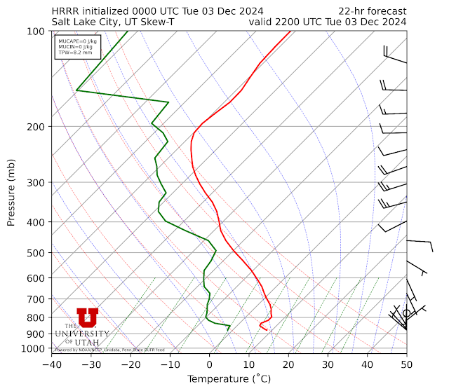
Upper air soundings collected at the airport yesterday morning and this morning show very subtle but important changes.  Yesterday morning, the inversion base was elevated and near 860 mb (about 400 to 500 feet above the valley floor.  Beneath the inversion was the valley cold pool that contained the fog and low-level stratus clouds.  The flow was weak in and above this layer and didn't reach 20 knots until about 775 mb (about 3300 feet above the valley floor).  

Source: SPC

This morning, however, the inversion is based right on the valley floor and temperatures below about 800 mb (about 2500 feet above the valley floor) have warmed, whereas they have cooled aloft.  20 knot winds are now evident at around 800 mb.  

Source: SPC

So, we have scoured out some of the cold air at the lowest levels (resulting in the low-level warming), leaving the fog and pollution to being confined to near the valley floor.  

A look at the PM2.5 concentrations from PurpleAir shows we are still in the unhealthy for sensitive group levels across much of the valley floor, but along the east bench, there is a rim where concentrations are either good or moderate.  

Source: PurpleAir

This is an example of what meteorologists call top-down cold pool erosion.  The flow aloft is increasing and beginning to scour out the coldest air.  It's a tough job though.  It takes a lot of energy to scour out the remarkably cold and dense air that is currently at the lowest elevations.  It would be easier to scour that air out if we had a bonafide trough with cold air moving in at upper levels, but that's not on the docket for the next few days.

The models, due to lack of resolution, an inability to properly include the presence of such shallow features, and the challenges of incorporating the complicated nature of near-surface physical processes, are not particularly good at dealing with these top-down mixout events.  I'm not exactly sure how things will play out today, but my best guess is that a shallow layer of cold air and pollution will remain resident over the Great Salt Lake and the central and northern Salt Lake Valley.  It might retreat for a short time, only to return, including to the University of Utah and some bench areas, as the flow becomes upvalley and upslope with surface heating during the day.  

I'm also not sure about how things will play out over the next few days, but at the moment, I don't think we will fully crack the inversion and get a total mixout everywhere.  I think we will see a persistent cold air pool at low levels near the lake and in many low elevation areas in the Salt Lake Valley and along the Wasatch Front.  The southern Salt Lake Valley and upper bench areas may luck out at times with clearer air.  

Hopefully I'm wrong and we crack this thing.  

Sunday, December 17, 2023

Inversion Hell

Salt Lake City descended into Inversion Hell with the development of low clouds and increasing PM2.5 levels.

Today's MODIS imagery, taken around 1:30 PM local time, showed the coverage quite well with widespread low clouds (in some inastances fog) over much of the central Great Salt Lake, Skull Valley, Tooele Valley, northern Salt Lake Valley, and Davis County.  


During the satellite overpass above, the avenues foothills were cloud free, but that changed at around 4:30 when the clouds pushed into the upper Avenues.


The fog and low clouds would only be depressing if they weren't also accompanied by poor air quality.  Observations from Hawthorne Elementary along 700 East in Salt Lake City show a major increase in PM2.5 concentrations today to 45-49 ug/m3, solidly at Unhealthy for Sensitive Groups levels.  


The high temperature today at the Salt Lake City International Airport was only 32˚F.  For comparison, the maximum temperature on Mt. Baldy (11,000 ft) above Alta reached 33˚F.  

Given the meteorology of the day, I was interested in having a look at things from Ben Lomond Peak above north Ogden.  Being able to enjoy that summit in the wintertime on a clear day with light winds is extremely rare.  It is one of the most wind-raked places in the Wasatch.  Today, however, although the snow was wind jacked, the view was spectacular.  One could really see the majesty of the Wasatch Range from Willard Peak (to the north), then southward where the western face of the Wasatch rises abruptly from Ogden.  One could see pollution around North Ogden and Ogden, but then the northern edge of the low clouds, also evident in the MODIS image above, near border of Weber and Davis County.  


Here's a broader perspective.  


I'll be taking the day off tomorrow to recover and avoid breathing the outside air.  

Monday, February 6, 2023

Complexities of Valley Cold Pools

As wonderful as the snow we have had since yesterday is (14" at Alta Collins as of 8 AM), what was really fascinating about this storm is how it affected the valley cold pool and associated pollution that has been resident over the Salt Lake Valley the past few days.  

The valley cold pool is the layer of cold air that resides in the Salt Lake Valley during what are known colloquially as inversions.  I prefer the term cold pool because not all inversion events feature a true inversion in which temperature increases with height (the atmosphere can still be quite stable when the temperature decreases slowly with height but is not inverted).  In addition, in some instances the inversion is elevated, so it is not really correct to call the cold air beneath it the inversion.  

OK, enough semantics.  Valley cold pools can be deep or shallow.  They can mix out quickly or slowly.  Then can be eroded by surface heating (which warms the cold pool) or from the top down by the wind. 

Observations from Hawthorne Elementary School at 1700 South 700 East over the past several days show the buildup of pollution over the Salt Lake Valley during the last work week, with PM2.5 levels peaking at unhealthy levels on February 3rd (Friday) and 4th (Saturday).  

Source: Utah Division of Air Quality

However, on February 5th, something odd happens.  First, air quality improves dramatically from about 3 AM to 9 AM when PM2.5 declines from 52 ug/m3 to 11 ug/m3.  Then, it jumps up again, in just one hour, to 49 ug/m3.  Talk about snatching defeat from the jaws of victory!  Then there is a gradual reduction through this morning, although some pollution remains at this location.  We still have not fully mixed out!

So what is going on?  With the approach of the storm on Sunday, the valley cold pool scoured out in much of the valley except the northern end and near/over the Great Salt Lake and environs where elevations are lowest and the coldest of the cold air was resident.  Lake temperatures are also quite low now, near 0˚C, so on a relatively warm, cloudy night, the air over the lake is locally cold.  As a result, we mixed out a good portion of the valley, but as seen in the photo below, taken toward the southwest and Oquirrh Mountains from the Avenues at 7:47 AM, a thin lens of cold air and pollution remained over the northwest valley (and likely over the Great Salt Lake and environs).  


I thought perhaps Mother Nature would be able to fully scour out that cold pool, but she had other ideas.  Instead the cold pool pushed southward and eastward that morning extending across a good portion of the Salt Lake Valley by 9 AM.  Hence the jump in PM2.5 concentrations at Hawthorne Elementary.  

Looking to the SSW from the upper Aves

A little while later, it started to snow.  Snow can remove some pollution from the atmosphere, but the temperature of the air aloft and the strength of the flow, which was rather weak, were not sufficient to crack and mix out the cold pool.  By 4:37 PM, the clouds were starting to move out, but the cold pool and associated pollution remained over a good portion of the Salt Lake Valley.  


Here are a two more photos showing the incredibly shallow nature of the cold pool and pollution as the sun set.


Even this morning, the cold pool and pollution refuse to give up.  Pollution levels for much of the east bench are mostly in the good category, but there are still a few pockets in the moderate category remaining, especially in the lowest elevations and west valley.

Source: purpleair.com

Better computer models and approaches are needed to forecast such complexities than we have today.  Simulating shallow cold pools is a major challenge and requires not only high resolution, but also very good information on the land surface conditions, snow cover, etc.