We are currently mired in the first major inversion and air quality episode of the season, although I don't think it's been as bad as it could have.
First, the valley is mostly snow free. This likely leads to a bit more energy input into the atmosphere (due to less sunlight being reflected back to space and increased ground heat flux) and perhaps a bit of a decrease in particulate matter generated by photochemical processes (although this is not my area so I'm speculating).
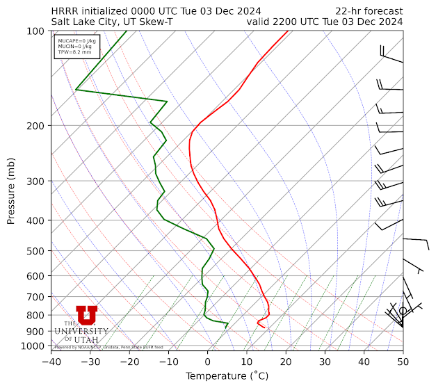
In the case of the former, the soundings released at the Salt Lake International Airport at 0000 UTC each afternoon are too late to capture the structure of the convective boundary layer that develops each afternoon. The convective boundary layer is the part of the atmosphere in which surface heating by the sun leads to vigorous vertical motions (the updrafts are sometimes called thermals) and mixing. The depth of the afternoon convective boundary layer varies from meters to kilometers, with the former happening during the strongest inversions and the latter on hot days in the summer.
HRRR model forecasts have suggested that the afternoon convective boundary layers during this afternoon have been about 50 mb or 500 meters deep. An example is below.
That's deeper than we would see with snow on the ground and during our strongest inversion events, which might feature a boundary layer that's only a couple hundred meters deep, leading to a bit more dilution of this event.For those in the northeast Salt Lake Valley, this event has also featured some enhanced easterly flow. This is a result of the structure of the "Rex Block" pattern over the western United States. A Rex block features an upper-level high pressure system to the north and an upper-level low pressure system to the south. Salt Lake City has been wedged between these two features, contributing to broad easterly to northeasterly flow in the northeastern part of the valley each morning, including this morning.
 |
| Source: Mesowest |
Such a flow pattern is not entirely unusual on clear mornings, but it seems like it may be a bit deeper and more effective at diluting the pollution each night. PM2.5 estimates from the PurpleAir network this morning, for example, show considerable variability along the northeast bench, but several stations with low values west (and downstream in the morning) of Emigration Canyon and in the Olympus Cove Area. In the case of the former, low values extend farther west to at least State Street. In contrast, PM2.5 estimates are uniformly high in the western valley.
 |
| Source: purpleair.com (screenshot at 0708 MST 4 Dec 2024) |
The nocturnal "flushing" of the air pollution during this event is well illustrated by the measurements from Tracy Aviary in Liberty Park. There is a clear see saw of PM2.5 concentrations, which drop each night and then increase each morning at about 9 AM.
Similar but even more pronounced behavior is observed at our Mountain Meteorology Lab near the mouth of Red Butte Canyon on the University of Utah campus where we also have colocated meteorological observations. Yesterday, for example, PM2.5 concentrations increased rapidly at about 10 AM. Prior to that, the winds were ENE and coming down canyon. At 10 AM, they became calm and then shortly thereafter shifted to SW, bringing in the gunk. Then, at 5 PM, the PM2.5 began to drop. This corresponded with the return of the ENE down valley flow. That ENE downvalley flow persisted all night long, with PM2.5 levels dropping eventually to 5-10 ug/m2.
These trends cannot be explained by local emissions or photochemistry. They are related to meteorology and the diurnal variations of winds in the northeastern Salt Lake Valley.


Love learning something new every time you post!
ReplyDeleteThanks Jim. Go easterlies!
ReplyDeleteThanks Jim. You’re a gem.
ReplyDeleteWhy is this occuring in NE SL Valley and not near the cottonwoods? Is it latitude, or is it that the Wasatch crest blocks the NE flow? In other words is it the same phenomenon as easterly wind events that tend to spare the East bench down in Sandy etc?
ReplyDeleteThis is not necessarily a question with an easy answer. I'll answer it with a short, but incomplete answer.
DeleteThe terrain east of the NE Salt Lake Valley is lower than it is around the cottonwoods, with more canyons. This makes it a bit more likely to see broader easterly flow.
There is definitely outflow from Little Cottonwood as it is is not uncommon to see the "triangle" neighborhood at the base of the canyon cleaner in the morning. However, the easterlies there (and perhaps from BCC) are localized and not as widespread as they sometimes are in the NE valley.
Is there a risk that this NE SLC nightly flush provided from the creek bottom downward flows is reducing a.m. pollution measurements at the Hawthorne elementary station and therein making DAQ’s county-wide AQ summary stat appear lower and healthier than it really is? (Showing less danger than the unofficial purple air sensors indicate? )
ReplyDeleteI suspect that in situations like this the 24-h mean at Hawthorne is probably lower than in the West Valley. DAQ actually has multiple sensors in the valley. They just don't provide real-time data at them all on their web site. Whether or not their air quality reports for the county (at https://air.utah.gov/) should be based solely on data from Hawthorne is something worthy of debate.
Delete