Thursday, February 27, 2020

Wither Nordic Skiing?

When it comes to the impact of global warming on snow, there will be few (if any) winners but some will suffer more than others.  Lower elevations are generally more vulnerable than higher elevation areas since temperature decreases with height.  For a given increment of warming, lower elevation regions see an event greater fraction of precipitation fall as rain, more and more substantial snow loss events, and greater loss of shoulder-season snowfall and snow compared to upper-elevation regions.

The vast majority of Nordic (i.e., cross country) ski centers and public trails are located in valleys and at relatively low elevation.  Thus, Nordic skiing is and will be suffering more than Alpine skiing, especially in ski regions where there is great vertical relief, such as Utah and the European Alps. 

For the most part, this has been a dismal Nordic ski season in Europe, including the Alps and Scandanavia.  Most of the Nordic races I've watched have featured snow only at the venue or only at the trail.  Below is an example from Falun, Sweden in early February. 

Source: NodicFocus
A big reason for this is exceptional warmth in Eurasia.  In January, for example, the biggest warm anomalies globally were in north-central Eurasia, although western Europe was also well above average.  
Source: NOAA/NCEI
Numerous warm records have fallen this winter, including the highest temperature ever measured in Scandinavia in any winter month

Extreme warmth of this type reflects both natural variability and global warming.  The dice in our warming climate are increasingly loaded to roll above average temperatures and warm extremes.  Anomalous cold can occur, such as Alaska during January, but the odds of that is decreasing and note how much of the planet is in the red in the plot above (and this is based on a 1981-2010 base period – it would be even redder if we used a 30-year base period from the early or middle 20th century).

In Utah, with the exception of Solitude, cross-country ski areas are located generally at low elevation.  For example, North Fork Park, Mountain Dell, and Soldier Hollow are below 6000 feet.  Round Valley, White Pine, and Jeremy Ranch are below 7000 feet.  We've had a good Nordic season this year, but these are elevations with vulnerable snow climates.  There will still be year-to-year variations in snow conditions, but I fear in the coming decades, we will find that the number of days of viable Nordic skiing in these areas will be on the decline, and that will be a damn shame. 

Tuesday, February 25, 2020

Transformative Student Experiences in Alpine Meteorology: REALM

Excitement is running high in my department as we prepare to host the Research Experiences In ALpine Meteorology (REALM) program this summer.


REALM is a National Science Foundation sponsored Research Experiences for Undergraduates (REU) program designed to enable the active participation of undergraduates in research.  What is unique about REALM is its focus on mountain weather.  We have received applications from students with diverse backgrounds from all over the United States.  Those accepted into the program will have an opportunity to learn and recreate in the mountains of Utah, which I expect will be transformative for many.  I personally remember my first trip to Utah when I was 16 years old and how our trip up Little Cottonwood Canyon further kindled my interest in mountain weather and winter storms.

Support from the National Science Foundation and University of Utah provides ten students with lodging, travel funds, and a stipend.  From late May to early August, these students will be in residence at the University of Utah and conducting research with faculty in the atmospheric and related sciences; developing professional communication, leadership, and teamwork skills; and gaining new understanding of mountain weather and climate.

Interest in the program is incredibly high.  We have received 145 applications from outstanding students!

Donor support can greatly enhance the REALM program.  Here are a few examples:
  • $100 pays for a weekly lunch with presentations by faculty, post-doctoral researchers, and graduate students within the Department of Atmospheric Sciences.
  • $200 provides prizes for year-end poster sessions.
  • $400 provides meals at Silver Fork Lodge for REALM orientation day.
  • $600 hosts a networking and socializing event with other STEM-related REU programs on campus such as those in Physics and Astronomy, Chemistry, and Material Sciences.
  • $3,000 covers student travel to Storm Peak Laboratory in Steamboat Springs, Colorado, a high elevation atmospheric research facility, including a visit to an air-quality monitoring site in the oil/gas fields of the Uinta Basin.
  • $10,000 enables REALM to admit an additional student into the program.
Gifts of any amount are greatly appreciated.  Please consider making a contribution today to help provide students with a transformative research experience.  Contributions can easily be made via the giving page for the University of Utah Atmospheric Sciences Department at https://auxiliary.apps.utah.edu/ugive/designation/107.  Simply indicate your desire for your contribution to be directed to REALM in the special instructions box.

Monday, February 24, 2020

The Overnight Blow

Strong winds accompanied a cold front that moved through northern Utah last night.  In my neighborhood, it's garbage pickup day and there were many tipped cans and much garbage strewn about, not to mention bleary-eyed people who were awoken in the night by windows rattling. 

The strong winds came in the northwesterly flow following the frontal passage.  Peak gusts at the Salt Lake City International Airport (41 mph) occurred at about 0820 UTC (0120 MST).  The situation shortly after that at 0900 UTC (0200 MST) when I was awoken by the storm is shown below and illustrates the widespread northwesterly postfrontal flow. 


A quick look at the overnight observations shows many valley sites recorded peak gusts of over 50 mph.  The peak gust in the Salt Lake Valley appears to be 59 mph on the Baccus Highway (SR 11) near 6200 South (a somewhat elevated location on the west bench.  The University of Utah reached 50 mph on the top of the 8 story William Browning Building. 

It was nuking in the mountains as well.  While ridgetop gusts hit 100 mph at one location in the central Wasatch this morning, most notably, there was a 73 mph gust at Parley's Summit, which is quite impressive for that location.

By and large, my impression is that we didn't do a great job letting people know it was going to blow as hard as it did.  It's easiest for me to go back and look at NWS forecasts as they are archived and the zone forecast issued for the Salt Lake and Tooele Valleys at 304 PM yesterday afternoon has no mention of wind.

That being said, the NWS area forecast discussions did mention the potential for gusty winds behind the front, but I think overall we (i.e., the weather community) could have perhaps done a better job of indicating the strength of the gusts.  I think people were surprised, although in the end, these don't appear to have been damaging winds in the lowlands. 

Meanwhile, as of 8 AM, Alta-Collins has picked up 3 inches.  However, we'll see some snow showers through tonight.  My guess is another 2-4 inches.  Do your snow dances as this is it through at least Saturday.

Sunday, February 23, 2020

Sunday Tidbits

A few tidbits today for your Sunday reading.

Lone Peak Wilderness

Is there a more spectacular near-urban wilderness in the contiguous United States as spectacular as the Lone Peak Wilderness? 

It's a rugged place, with much of it more accessible in winter and spring than summer and fall. 

Yesterday near White Baldy
Hard to believe there was talk at one time of putting a tram up the iconic Pfeifferhorn.  Thankfully that never happened.  

Wasatch Oddities

One of the curious aspects of the central Wasatch Mountains is that the highest terrain isn't on the mountain "crest" or hydrologic divide like it is in the northern Wasatch, but west of it.  A good example of this is provided below, looking north from upper Red Pine Canyon at the high ridgeline above Little Cottonwood.  Note how the terrain is highest from Twin Peaks on the left (west) to Monte Cristo Peak center right, and then descends as one moves further east to the Emmas and environs above Alta.  


I've often wondered what the ramifications of this topographic configuration are for winter storms. 

Not Out of the Woods Yet

I've been hearing a lot about what a good snowpack we have and how this bodes well for the spring runoff, but as I've suggested in previous posts, we're not out of the woods yet. 

It's important to recognize that we have some basins in central Utah that are running near or somewhat below median.  In other areas, many basins are above but not way above median. 


Additionally, it is only late February.  We still have one to two months of snow accumulation season left, depending on elevation.  Much is going to depend on the weather over the next 4 to 6 weeks.  Further, we live in a warmer climate now and while that does not prevent us from having a cold and snowy March and April, we need to recognize that the dice are becoming loaded in a way that we are going to see more springtime snowpack ablation (loss) events and less efficient runoff and reservoir recharge.  Thus, a near median snowpack in late February today doesn't provide as good of odds for a near average spring runoff as 40 years ago.   

Friday, February 21, 2020

NOAA Computer Upgrade

NOAA has announced an upgrade to its computing resources for weather and climate prediction. 

The full press release is available at https://www.noaa.gov/media-release/us-to-triple-operational-weather-and-climate-supercomputing-capacity.  The upgrade consists of two Cray computers, each with a capacity of 12 petaflops (typically two identical systems are used in weather computing to ensure redundancy and operational reliability).  A petaflop is one quadrillion floating-point operations per second. 

The NOAA press release suggests that this will keep the agency on par with leading weather forecast centers around the world.  It will help, and it will lead to improved forecasting for the United States, but I'm not sure it will enable us to get on par with ECMWF, at least in terms of global weather prediction.  In January, the ECMWF signed a contract in January that is estimated to provide two computers, each estimated to have a capacity of 20 petaflops.  Given that the ECMWF focuses on global prediction (and runs fewer modeling systems), this will likely mean they will be able to dedicate more horsepower to their global forecast system.  Additionally, the UK is apparently spending $1.5 billion for a new supercomputer for weather and climate forecasting, although it's unclear how much of this will go to operational numerical weather prediction. 

My view is that this is a positive step forward, but the US would benefit greatly from greater investment in computer infrastructure for operational numerical weather prediction. 

Thursday, February 20, 2020

What an Airmass!

Sunrise view this morning in the Avenues
You'll be hard pressed to find a more spectacular airmass than the one resident over northern Utah this morning.  Not a cloud in the sky and unlimited visibility.  Simply spectacular!

Under clear skies this time of year, one might expect a large difference between the maximum and minimum temperatures, but that hasn't been the case at the Salt Lake City Airport.  Yesterday's maximum was 36˚F and the overnight minimum was only about 21˚F (it might go slightly lower than that).  That's a 15˚F range, which is smaller than average (19˚F) for this time of year.

Source: MesoWest
Tour our southeast, the Rush Valley south of Tooele can often get quite cold, and last night it got down to about 6˚F.  That's impressive compared to Salt Lake City, but still only 28˚F cooler than yesterday's max.  Here too, the daily range of temperature is a bit subdued despite the clear skies.


In contrast, if we go east of the Wasatch, temperatures are really bottoming out and we're seeing large daily temperature ranges.  The ultimate is of course Peter Sinks where it has been below -43˚F the last two days and where it got down to -48˚F yesterday.  I kid you not!

Source: MesoWest
The sinks have always been a bit of a meteorological oddity.  Nobody lives there, so such temperature extremes are fascinating but not all that important for human activity.  However, when it is cold there, it is often cold in places like Randolph, which is east of the Bear River Range near the Wyoming border and indeed temperatures last night at one station fell to just below -25˚F. 

Source: MesoWest
Finally, how about the Park City area and the Cottonwoods?  The situation this morning is simply spectacular if you are a lover of valley and basin cold pools.  -11˚F at Kimball Junction and -9˚F at Silver Creek Junction and along SR-224.  That's a cold start for skiing, but check out how the temperatures increase with elevation, reaching the 20s at some upper-mountain locations. 

Source: MesoWest
Big Cottonwood is also remarkable with -8˚F at Reynolds Flat an 22˚F immediately above it on the summit of Reynolds Peak.  Dawn patrollers in that area must have had an interesting climb into the warmth this morning.  

To summarize, a spectacular airmass is in place, but the daily temperature range, relative to climatological expectations, is a bit subdued west of the Wasatch.  A clue as to why is provided in the MODIS satellite image from yesterday.  Note the lack of cloud cover along the Wasatch Front and valley locations west, whereas there is extensive cloud cover over and east of the Wasatch.  


If it was snow covered in the Salt Lake Valley, we probably would have been much colder last night.  

Wednesday, February 19, 2020

Comparison of This Season with 2018/19

Snowpack water equivalent observations from Snowbird show that, for the first time since mid October, we are now running behind the 2018/19 season. 

Source: NWS/CBRFC
The numbers are so close, however, that it's probably better to say that we're in a dead heat given the errors and uncertainty that exist in such measurements.

Elsewhere in the central Wasatch, Mill D North is also in a dead heat, but Brighton and Thaynes Canyon are lagging behind.

Source: NWS/CBRFC
Source: NWS/CBRFC

Source: NWS/CBRFC
Further, if one assumes these observations are representative (and that is not necessarily a good assumption, but what the hell), these observations suggest that western portion of the central Wasatch has been favored this winter more so than usual.  This has led to above median snowpack in the western portion and near median in the eastern portion.  I note, however, that this is probably not a statistically or physically representative sample given that there are only four points.

Another way to think of that is that the contrast between Little Cottonwood and Park City is stronger this year than in a median winter. 

I wasn't here for most of last winter, but the skiing cognoscenti and snow snobs that I tour with tell me they clearly rate this season above last, at least so far.  Observations from the western portion of the central Wasatch seem to support that.  The situation on the Park City Ridgeline and Wasatch back is less clear. 

Share your thoughts.

Tuesday, February 18, 2020

Wasatch Backcountry Appreciation Day

Today is apparently Wasatch Backcountry Appreciation Day.  I saw that in a tweet yesterday, so anything is possible.  Everyday should be Wasatch Backcountry Appreciation Day.  In celebration, I leave you with some photos, in no particular order, and remind you that life is short and powder precious. 


Sunday, February 16, 2020

"Diabatic" Effects and Snow Level

Still on eastern time, I was up early this morning, well before the crack of dawn.  A quick walk outside revealed relatively mild temperatures, a subjective observation confirmed by the morning sounding from the Salt Lake City Airport, which showed a surface temperature of 38˚F and a freezing level near 8000 feet.


Based on temperature alone, one would expect rain on the valley floor and benches from a sounding like that, but a couple of hours later, it was snowing and accumulating on grassy surfaces.


Did a front go through, lowering the temperature, freezing level, and snow level?  No.  The lowering of temperature, freezing level, and snow level occurred due to sublimation, evaporation, and melting of precipitation.  These processes are called diabatic effects by meteorologists. 

To anticipate such effects, it is best not to use temperature, but instead wet-bulb temperature.  Wet-bulb temperature is the temperature that air will cool too if you evaporate water into it.  When the relative humidity is 100%, the wet-bulb temperature equals the temperature, but when the relative humidity is less than 100%, the wet-bulb temperature is lower than the temperature. 

Most Utahns have first-hand experience with the cooling effects of evaporation.  A swamp cooler, for example, can potentially cool the air to the wet-bulb temperature.  When the relative humidity is low, a swamp cooler can lower the air temperature significantly.  When the relative humidity is high, however, the cooling effect is limited. 

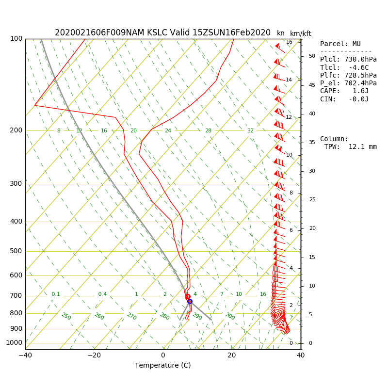
Today's sounding was primed for substantial cooling.  If you look at it, there is a large difference between the air temperature (red line) and the dew point (green line) below 700 mb (10,000 ft).  There is a thin blue line between the temperature and dew point lines that is the profile of wet-bulb temperature.  Note that the wet-bulb temperature is below 0˚C above 850 mb (about 5,000 ft).  Thus, if you can precipitate into that layer, the evaporation of liquid water and the sublimation of snow can potentially drop the freezing level to about 5000 feet, with the snow level just a bit lower than that.

This is what happened.  This morning, when precipitation increased, diabatic processes led to a decrease in temperature and a dramatic lowering of the snow level.

A look at surface observations shows, however, that we haven't quite cooled to the wet-bulb temperature.  Below is the temperature trace at the University of Utah.  At about 7 AM (far right side of the graph), the temperature (red line) decreased abruptly, the dewpoint (green line) rose abruptly, and the relative humidity (blue line) increased abruptly).  This is consistent with cooling and moistening through evaporation and sublimation, with temperature and dew point converging to the wet bulb temperature. 


However, they don't quite meet.  The relative humidity ends up at about 90%.  Thus we are close but not quite at the dew point temperature. 

There is one other effect that I've swept under the rug here and that is melting.  With temperatures above 0˚C, the flakes falling at my house are also melting.  This also takes energy out of the atmosphere, leading to a cooling effect.  It is probably playing some role as well. 

In situations like today's, precisely predicting snow level and, for the valley and benches whether or not the precipitation will be snow or rain, can be challenging.  A look at NAM forecast soundings shows temperatures at all levels below 0˚C at 1500 UTC (0800 MST).  Note, however, that the NAM terrain is higher than the real-world terrain, so in reality, we're just above 0˚C on the benches and in the valley.
 Later today, however, temperatures in the lower part of the sounding have climbed to > 0˚C as warmer air moves in from the west and we get a little daytime surface heating.  This yields a higher freezing level (near 800 mb or about 6500 feet). 
This will probably mean snow levels will rise today, resulting in the bench snow turning to rain later this morning or this afternoon. 

Saturday, February 15, 2020

Snow Report and Prospects

I finally returned to Salt Lake City last night after a week in Greenbelt, Maryland at the National Weather Service Weather Prediction Center. 

It was a good week professionally, but it was mostly cloudy and rainy and my exercise was limited to the stationary bike at the hotel and a walk through the University of Maryland campus.  The only evidence of mountain weather that I saw there was a post-frontal lenticular generated by the upstream Appalachians on Friday morning. 

Thus, I was chomping at the bit to get out this morning and headed up to Round Valley for an early morning skate.  Conditions were excellent.  The snow was firm and fast with a nice groomer buff on top.  I didn't even work hard and still came in with my fastest pace of the season. 

Having not been in the mountains yet, I can only assume that we are in need of a reset for touring and alpine skiing.  It looks pretty good that this will happen.  The NAM forecast loop below shows mountain precipitation spreading southward down the Wasatch Range tonight, intensifying and continuing tomorrow, and then periods of snow continuing into President's Day.


The storm starts out warm with 700 mb temperatures between -4.5˚C and -6˚C through tomorrow afternoon, so snow density tonight and tomorrow will be above average.  Our algorithms are suggesting around 10% water content during that period.  Later tomorrow, temperatures should fall some and we should get some drier snow, leading to right-side up conditions for Monday. 

At Alta, the NAM generates 5.5 inches through 5 PM Sunday and then another 4.5 inches through 5 PM Monday.  I often use the NAM as the low end for the range at Alta, which would mean 5-10" at Alta through 5 PM Sunday and another 4-8" through 5 PM Monday. 

The downscaled SREF mean gives somewhat similar numbers with a mean storm total by 5 PM Monday (18/00Z) of 15 inches and a range of 10-18".  Basically, a goldilocks storm.


My take is that tomorrow is a day of cream on crust that should improve with time as snow continues to accumulate.  Cooling beginning tomorrow afternoon should yield right-side-up snow on Monday, which could offer up some nice powder skiing.

Enjoy it.  We'll likely be mainly dry the rest of the work week after Monday and possibly into next weekend.

Sunday, February 9, 2020

East Winds and Snowfall Break

I'm at the Salt Lake airport to do my duties as a principal investigator and suffer through a week on the east coast away from snow.  The view this morning of the northern Wasatch was beautiful, with a spectacular lenticular cloud sitting right on the Wasatch crest.  


Such a cloud pattern is consistent with easterly downslope flow, as are the low level cumulus clouds closer to the airport.  Those clouds are likely forming in the updraft where the downslope flow experiences a hydraulic jump, similar to what occurs in some situations during water flow over a rock. 

The easterlies are quite evident in the weather observations near the mountains and to the east.

Source: MesoWest
Curiously, if you look carefully, you can find observations with westerly flow just to the west of bountiful and at the Salt Lake City Airport.  That is evidence of a rotor, a circulation that typically forms just downstream of the hydraulic jump.  Below is a conceptual model of the flow in cases like this.  Imagine that you are looking southward along the northern Wasatch, with easterly flow from left to right and the rotor just downstream.  Note the shallow cumulus cloud that forms downstream of the hydraulic jump over the rotor circulation. 

Source: Whiteman (2000)
Givent that I'm leaving town, you might be excited about more snow, but the Steenburgh effect doesn't seem to be working this week.  The NAEFS keeps things pretty dry until the 14th.


That's probably for the best.  Our snow safety teams need a break.