Posts

Showing posts with the label Weather

Some Updates

Image
Great to see that temperatures in Salt Lake City have been quite pleasant the past couple of days.  Below is the time series from the University of Utah and after 90+ on Friday the 26th, temps have been below 75 since and as low as the low 40s.   But I was sad to see that three firefighters were killed responding to the Knowles Fire in western Colorado.  Such a tragic reminder of the danger that wildland firefighters face every day.  Meanwhile here in Europe the heatwave has started to abate.  I was told that Innsbruck set an all-time record high on Saturday of 38.7C/101.6F (the old record was 38.5C).  We were out of town and at higher altitude so fortunately didn't experience it.  That's not as bad as observed in France and Germany and a few other lower-elevation areas that were above 40C/104F.   Today (Tuesday, June 30) was our last full day in Innsbruck.  We have a short vacation before returning to Utah for the latter two-thirds...

A Dry Weekend

Image
It's a rarity here in the Great Salt Lake rainforest, but it looks like we have a dry spell settling in that will last through the weekend.   The trough that brought us rain over the past few days is exiting the area today.  On Saturday, a low-amplitude upper-level ridge looks to be moving in, with no monsoon moisture or Pacific storms to be found in our area.   There is a brush-by system that flirts with northern Utah late Sunday but right now the precipitation from that looks not push into Utah through 0000 UTC 20 Oct (1800 MDT Sunday). That system could bring a bit of precipitation to northern Utah, mainly in the mountains, on Sunday night. For Alta Collins, for example, a bit over half of the Utah Snow Ensemble members produce no precipitation Sunday night, but a fee give us some light amounts Sunday Night, with a couple doing a bit better than that.  That's the main threat for precipitation over the next few days if you are hoping to add to aour alread...

It's a Trough

Image
The models are advertising the slow movement of a mid-latitude trough across the western US this week.  It's not an unusually deep one, and we've had some weak troughs move through the area recently, but this is one of the better "put together" troughs we have seen in a long time.   The overnight GFS forecast has the trough approaching the California coast later this afternoon (0000 UTC 9 September with rain in the California and Orgegon Coastal Mountains.  Oh to be there for this frontal rain.  It just warms the cockles of my heart to see it! As exciting as that is to see, the trough moves very slowly across the western US and is not a strong one.  The result for us will be a few days of light-moderate southerly to southwesterly flow at mountaintop level and a bit of enhanced southerly flow for the valleys.  A few pockets of monsoon moisture might be embedded in this flow, but at least right now, hit-and-miss thunderstorms look to predominate through...

The Heat Is Back On

Image
Our brief run of below average temperatures will probably end today (Thursday, June 26) after five wonderfully cool days, including Sunday, June 22nd when we only reached 65.  The hiking that day was wonderfully cool, especially in the morning.  No complaints about wet brush, which we encountered a lot of, as it was nice to enjoy the cool, moist air. The National Weather Service is forecasting a high of 93 for the Satl Lake City Airport today, which will push us back above average. Highs in the 90s look to continue for the forseeable future.  Sigh...

It's a Trough!

Image
It will take a while to get here, but a bonafide trough will be coming to Utah for the weekend. Before that, we're going to be in the so-called warm-before-the-storm (in this case a dry frontal passage with dust) with a ridge building over Utah today. The ridge will be followed by the development of warm southwesterly flow ahead of the trough later in the week, as illustrated by the GFS forecast below for 0000 UTC 21 June (6 PM MDT Friday). Although yesterday's high was "only" 87 and this morning was pleasant, our July like weather returns for the rest of the work week with NWS forecast highs for the Salt Lake City airport of 92 today, 102 Thursday, and 96 on Friday.  Critical fire weather conditions will be in place for much of this period. Saturday is a transition day with the front forecast to be moving over northern Utah at 0000 UTC 22 June (6 PM MDT Saturday).   Depending on your location and exposure, this looks like a recipe for dust Friday and Saturday in both...

Three Major Weather Players

Image
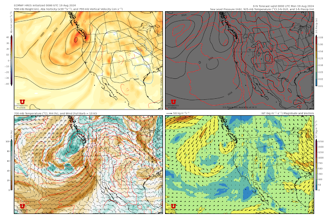
The weather over the past week has been wonderful by my standards. Four of the past six days have seen highs in the 80s, lows have been in the 60's, and we've had measurable rain at the airport on four days.  You might have done even better than that depending on where you live.   The GFS analysis for 0000 UTC 19 August (6 PM MDT Sunday) shows the situation as of yesterday afternoon.  An upper-level ridge predominates over west Texas and New Mexico with a deep upper level trough off the Pacific Northwest Coast.   This has put Utah in a so-called "monsoonal" flow around the upper-level ridge.   This general pattern will predominate over the next several days, with changes in the position and strength of the upper-level ridge and trough affecting our temperatures and likelihood of precipitation.  For example, the ECMWF forecast valid 0000 UTC 21 Aug (6 PM Tuesday) shows a slight westward shift in the ridge, weakening of the trough, and a bit mo...

Cool Change

Image
With high temperatures this past weekend of 100 and 101 at the Salt Lake City International Airport, today's "cool change" is greatly appreciated.  As I write this at about 3:10 PM, the temperature at the airport is only 81 and it is looking likely that we won't even eclipse 90 today.   Those long in the tooth might remember that Cool Change was a 70's hit for the Little River Band. The Little River Band was from Australia, where the Cool Change is an actual meteorological phenomenon that produces dramatic temperature falls from oppressive summertime heat in southeast Australia.   The current drop in temperature is perhaps not as large or dramatic as the Australian Cool Change, but we'll take it.  I addition, the extended forecast is actually a good one for early July, with persistent ridging upstream along the Pacific coast (e.g., GFS forecast valid 0000 UTC 7 July below) putting northern Utah in northwesterly flow.   That's much better than the ...

Beautiful Spring Weather

Image
If you look carefully, you can see a couple of clouds in the Mt. Baldy web cam from Alta Ski Area this morning. Source: Alta Ski Area Those are not enough, however, to mar the incredible run of beautiful weather we have had since the demise of the easterlies on Saturday.   Indeed, that run will continue today with clear skies and temperatures into the upper 60s in the valley.  If we can't have powder, this is a pretty good alternative.   A weak short-wave trough will come through tomorrow and bring in a few more clouds and maybe a spritz of a shower or upper-elevation snow shower for the mountains tomorrow.  Significant weather will hold off until the weekend when a cold front is expected to push across northern Utah on Saturday.  Current forecasts suggest that the front will arrive in the afternoon.  Below is the ECMWF forecast valid 2100 UTC 23 March (3 PM MDT Saturday) with the front approaching Salt Lake City. A real question mark for skiing w...

Great Fall Weekend Ahead

Image
We have a sublime WYSIWYG (What You See Is What You Get) forecast for this weekend.  Currently, parked under and upper-level ridge. Tomorrow we're parked under an upper-level ridge.   Sunday we're parked under an upper-level ridge. You get the point.  "Severe clear" is the operating phrase.  Enjoy the fall colors.  

Sunniest Ski Areas?

Image
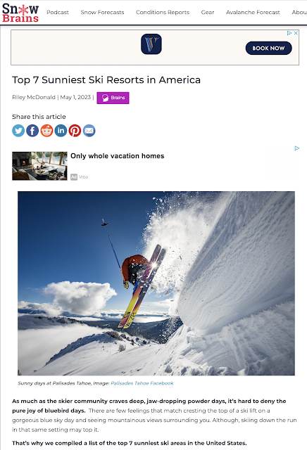
As much as people like to argue about whether or not ski area snowfall reports are legit, but perhaps there's more to argue about in the "day's of sunshine claim."   Snow Brains recently published a top 7 list of the sunniest ski resorts in America.  Coming in at #1 was Palisades Tahoe with "more than 300 sunny days per year." The 300 days of sunshine claim as been around for as long as I can remember.  When I was a kid, walking uphill both ways to school in sub-zero temperatures in upstate NY, I used to read promotional brochures from the Lake Tahoe area claiming more than 400" of snow and 300 days of sunshine and dream about how incredible the skiing must be there.  I mean, it must either be snowing or sunny!  What could be better.  Source:  https://visitlaketahoe.com/ski-and-snowboard/and-the-award-for-the-best-weather-to-ski-in-lake-tahoe /  However, there are many things that are puzzling about that number.  First, it is an annual n...

Quick Hitters

Image
 There's a lot going on today.  I'll have to go into rapid-fire mode. August Temperature Record a Lock?   2020 has opened up a bit more of a lead on 2013 for the warmest August on record.  The gap is now 1.1˚F.   The max/min temps for the last days of August 2013 were 84/71, 84/67, 93/67, 97/71, 97/71, 93/72.   NWS forecast calls for 96/68*, 94/71, 93/68, 92/67, 89/67, 81/60 (*last nights minimum).   Someone can run the numbers, but I'm betting if the forecast verifies, we'll have a new record given the current 1.1˚F lead.   August Precipitation Record a Lock?    Nope.  0.10" from overnight storms.  Easy come, easy go.   Cooling Coming! I'll just put this forecast here because it calls for an actual push of cooler air into northern Utah late Sunday.  It won't feel like fall, but it will drop us a bit below averages for Monday and Tuesday.  Did I just say that? Laura Looking Very Dangerous...

A Pleasant June So Far (By Recent Standards)

Image
The average temperature at the Salt Lake City International Airport for the first three weeks of June was 68.9˚F.  This is quite comparable to the first three weeks of last June (68.6˚F) and considerably cooler than the first three weeks of June 2015, 2016, 2017, and 2018, when mean temperatures were at or above 74˚F.  Source: NOAA Regional Climate Centers So, compared to recent standards, this has been a pretty nice June.  However, it's still about 2.4˚F warmer than the 20th century average for Salt Lake City. It's also been a June of extremes.  Just check out the roller coaster we've been on below.  We hit 100 on June 5, the earliest 100 ever recorded at the airport, then plunged downward with highs of 60 and 55 just 2 and 3 days later, respectively.  We subsequently seen big swings continue through today.    Source: National Weather Service Today looks splendid with a high of 84 forecast for the Salt Lake City Airport by the Na...

Cooler Weekend Ahead

Image
Highs in the 80s are quite tolerable in Utah, but 90s not so much.  Yesterday's high of 91 and today's forecast high of 95 are outside my tolerance limits.   The good news is that we have some cooler air moving in tomorrow.  The NAM 850-mb (about 5000 feet above sea level) temperature and wind forecast valid at 1500 UTC (0900 MDT) tomorrow morning shows a cold front moving across northern Utah that should knock temperatures down for the weekend.   National Weather Service Forecast for the Salt Lake City airport calls for a high of 85 tomorrow and a very pleasant 76 on Sunday.   Enjoy, but keep your distance.  

"Normal" Spring to Continue

Image
As far as Aprils go, this one hasn't been too exciting or unusual from a weather standpoint.  For the first 19 days of the month, the average temperature was 48.9˚F, which would rate as the 46th warmest or 45th coolest out of 92 years of record keeping at the Salt Lake City International Airport.  Source: NOAA Regional Climate Centers In other words, we are right at the median, or the middle of the distribution of past Aprils.  I don't say this much, but that's "normal" or as close to it as you can get.  If one were to quibble, it might be with regards to precipitation as the Airport has only had 0.26 inches of rain so far, which would be below average.  Still, I would rate this April as fairly typical and not all that unusual.  The short-range forecast also looks like typical spring.  Highs in the 60s today over northern Utah with some showers and thunderstorms in central and southern Utah.  Tomorrow looks like more of the same, then a ...

Major Storylines of the 2010s and 2020s

Image
With the 2010s coming to a close, it's time to look back at the last 10 years and highlight some of the major storylines covered by the Wasatch Weather Weenies.  We first started posting in Fall 2010, so the 2010s were our true youth.  Be warned that the 2020s will be our adolescence. The 2010/11 Ski Season Let's start on a positive note with the 2010/11 ski season which I suspect we can all agree was the best in the last 10 years in Utah.  The photo below was taken in the Avenues foothills on November 29 . Things just got better from there.  It was full on by mid December as Alta reached a 100" deep snowpack on December 20th.   How's this for coverage in upper White Pine on December 24th. And Mother Nature just kept bringing the Goldilocks storms all winter long, right up through Memorial Day weekend when we were still skiing powder. While the powder was gone, Snowbird was for the 4th of July when my son and I were skiing on Mt. Rainier....

Persistent Large-Scale Pattern with Critters in the Woods

Image
I'm not sure how blogger will handle it, but the loop below has been purposefully designed to run at high speed and to repeat to illustrate three key points about the GFS forecast for the next ten days.  First, the large-scale pattern changes little with persistent upper-level ridging over the southwest U.S. and the westerly mid-latitude jet to our north.  There are variations in the strength of the ridge and the center of its circulation, but these are relatively modest. Second, one can see precipitation "pulsing" in the lower right-hand panel, which depicts the surface forecast and includes the 3-hour accumulated precipitation.  This pulsing reflects the influence of the sun, with precipitation increasing and becoming most common later in the day and in the early evening and becoming less common over night.  Third, as can be seen in the top two images which depict the upper-level pattern, there are some "critters in the woods" in terms of upper-level...

The Dog Days Start This Week

Image
It was wonderful to return to the Wasatch last weekend and find so much water and snow.  It's been several years since it looked like this in early July (since 2011) and it helped us ease back into the climate of Utah from the wetter Austrian Alps.  Even the Mt. Superior butterfly said hello.  I missed a fairly remarkable late spring.  The climate summary for Salt Lake City International Airport shows a relatively cool stretch from mid May with considerable rainfall, followed by frequent intrusions of cooler air through early July.  Such intrusions make for much more tolerable weather.  Source: NWS That changes this week.  We've had a weak trough move through overnight, providing us with somewhat refreshing air and highs in the 80s today and tomorrow.  After that, the GFS is advertising a very typical July pattern with strong ridging centered roughly on the four corners.   I'm no fan of 10-day icon based forecasts, ...