Sunday, May 29, 2022

Snow Update

A soggy Sunday has settled in over northern Utah.  One could complain given that it is the holiday weekend, but we need every soaking we can get in these droughty times.  

Alta is beginning to look wintery this morning.  

Overnight temperatures fell at Alta-Collins to 31˚F as of 7 am.  Water equivalent precipitation since midnight is about 0.5", with no accumulation so far on the interval stake, although how well it is being maintained is unclear.  

The web cam shows perhaps two inches.  


Call it cream on crust.  

The GFS has been pretty consistently calling for significant accumulations today, totaling 1.2 inches of water and, based on our snow-to-liquid algorithms, about 14 inches of snow from midnight last night to Monday afternoon.  


There's a certain amount of crapshootedness to these spring storms given their scattered, convective nature, but perhaps we can get one last day of fresh out of this event.  I suspect snow densities will be even higher than indicated above, which may limit accumulations to less than indicated above if water equivalents don't go big.  There will also be a sharp increase in accumulation with altitude as the transition zone is sitting in that 8000-9000 foot elevation range.  Late may snow.  Don't complain :-).

weather.utah.edu

Our Center for High Performance Computer performed a major software and hardware upgrade of our computer systems from Wednesday to Friday.  Things are up again, but some weather.utah.edu products are still not available.  


Tuesday, May 24, 2022

Dismal Snow Situation in the Eastern Alps

 It's looking like this past season was especially dismal for seasonal snow in the eastern Alps and I suspect by the end of summer it will have been one for the glaciers as well, if it isn't already.  

The Zugspitze on the border of Germany and Austria is my bellwether as there's a very good web cam there and it is at an elevation where there once was a glacier, but no more.  

This year looks to be a double whammy due to a "meh" snow season and the damage being done by Saharan Dust that was deposited onto the snowpack a few weeks ago.  

Below is the view looking south from the Zugspitze yesterday.  The snow cover is already spotty and covered with the Saharan Dust, which increases the absorption of solar radiation and the snowmelt.  

Source: https://www.foto-webcam.eu/

Below are images taken on the same day or prior day back to 2016 (also from https://www.foto-webcam.eu/), showing the especially poor snow coverage this year. 


Only 2020 is close, but even then, the coverage was more extensive.

Below is a view from late September of last year. 

It will be interesting to see how things look this September.  I suspect this year will be a big mass lost year at glaciers in the eastern Alps and perhaps the central and western Alps as well.  

Sunday, May 22, 2022

Build the Trails, Part II

When I first moved to Salt Lake City in the 1990s, purpose-built mountain-biking trails didn't exist near town, with the exception of the pipeline trail in Mill Creek Canyon, which I'm not sure was truly designed for mountain biking.  There was no Avenues Bonneville Shoreline Trail (BST).  I used to ride the fire road above Terrace Hills Drive and then hike a bike to the top of the Avenues Twin Peaks.  One could descend via that route or down the Bobsled or the Agony Escalator.  

In 1998 a friend and I had been looking at topo maps and decided that we should ride to Rudys Flat above  Bountiful via ridge thats west and north of City Creek Canyon.  Looked "doable" on the map.  There was to TrailForks or other app to give us a trail report. 

We left after work.  We road up the Ensign fire road past the various comms towers, which beyond the first set of towers was as bad then as it is today.  Then we started working our way out the ridge.  Initially it was a pretty good double track, then a lousy double track, then a single track, then a heard path.  The ridge is pretty lumpy and the route went straight up and straight down everything.  The vertical added up.  It started getting dark.  Finally we saw the trail down North Canyon and beelined too it.  We then descended and road home in the dark via paved roads.  I was depleted.  

I swore I'd never do it again, but a few years later I did, this time better equipped with more reasonable expectations.

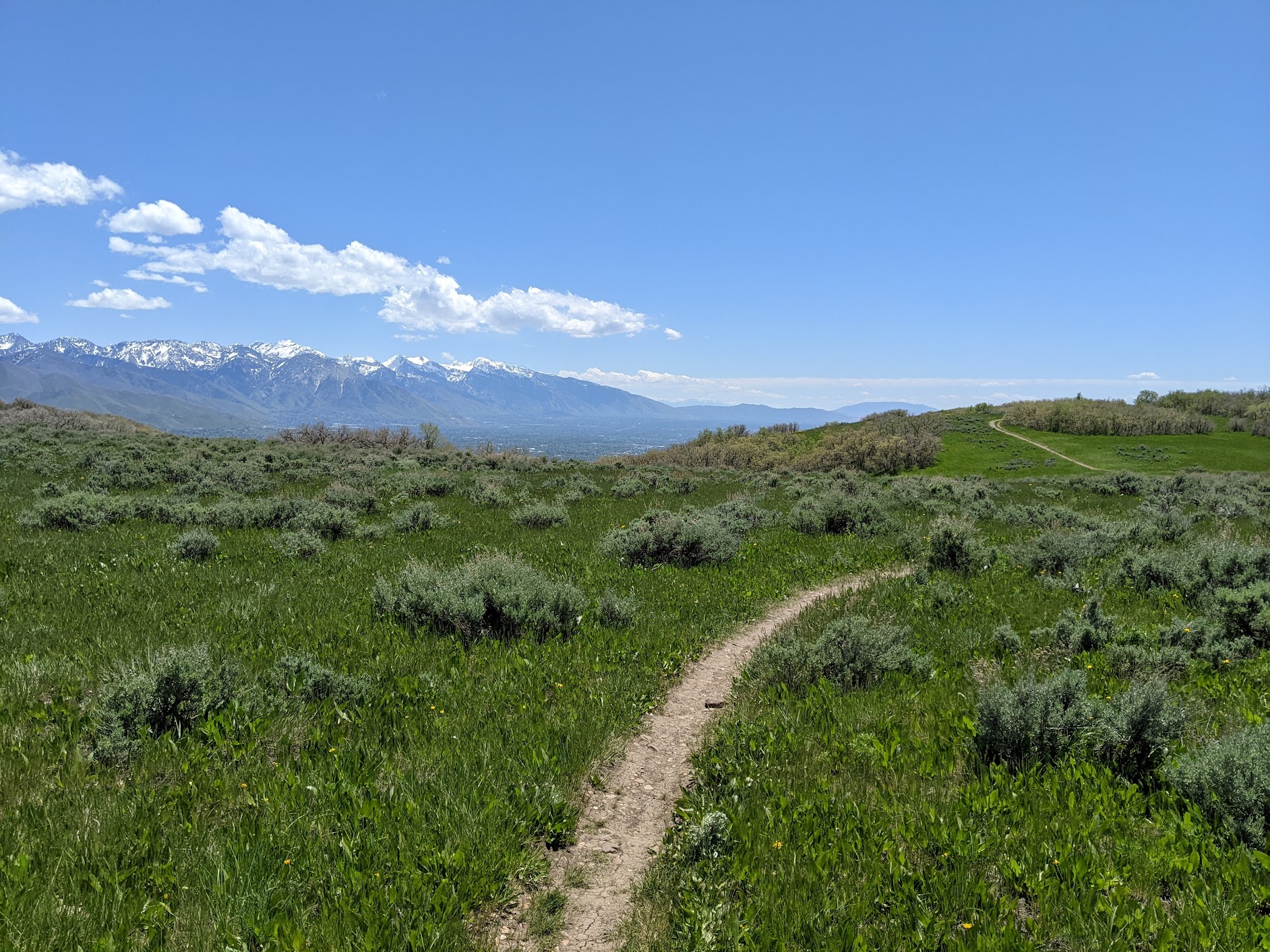
I always thought it would be a great place for some properly built trails.  Although not on the ridge, the BST from above is now nearly finished to North Canyon (I've read it's not quite to North Canyon yet, but if you have a more recent update, please comment).  I rode some of it yesterday and it offers up great views as it contours in and out of the scrub oak. 

Here and there, a dense carpet of vegetation covers the ground.

The trail is very well constructed and perhaps single track and a half rather than single track.  


It's fairly easy riding once there.  The route to it from Wild Rose has a steep section that requires some pushing, but it's not a biggie.  Perhaps a lower-angle option will eventually be constructed.  

We did ascend the old-school Eagle Crest trail to the ridge above City Creek to enjoy the views of the central Wasatch.  


This is an area I always thought could offer up some great biking and hiking and it is great to see more trails being built.  Really, the potential is enormous.  

It was also a sad reminder that while other communities are moving forward with trail construction and providing more opportunities for their residents, Salt Lake City continues the pause on trail construction in the Avenues Foothills.  Let's get that process going again.   The reality is that a new trail system will be better than what we have now.  

Wednesday, May 18, 2022

Build the Trails

It's prime season for biking and hiking in the Avenues foothills.  This year it seems especially lush and the vegetation is filling in nicely around the recently constructed trails.


There could be more trails available to hike and ride, but trail construction was halted in May of last year.  This was allegedly a "pause" that would last until that fall.  Then it was extended to this summer.  In April, the city council further extended the pause until at least spring 2023.  

My views align with those of Ashley Patterson's in her op/ed in yesterday's Salt Lake Tribune.  The Foothills Trail System Plan included three years of public input.  Those surprised by the construction successfully pushed the city to pause completion of the project.  Some legitimate concerns were raised and the trails community supports addressing these.  

On the other hand, we do not want to see trails construction stopped permanently or delayed significantly.  After the pause last year, consultants should have been hired to evaluate the trail construction plans, but that hasn't happened.  Instead, the can has been kicked down the road for another year.  

It is long past time for city council and Mayor Mendenhall to move this process forward.  Other communities along the Wasatch Front have built world-class multiuse trail systems.  We can too.  

For more information, see https://slctrailsalliance.org/

Tuesday, May 17, 2022

Cold Surge Coming

 There's a pretty good cold surge expected to push into northern Utah later this week.  By Friday afternoon, yesterday's high of 88˚F will be long forgotten.  

Below is the GFS forecast for 2100 UTC (3 PM MDT) Friday showing a short-wave trough moving through northern Utah with 700-mb (10,000 ft) temperatures near -8˚C.  

The GFS-derived Little Cottonwood forecast shows temperatures on Mt. Baldy dropping from 43˚F tomorrow afternoon to 13˚F Friday morning.  Your Friday morning dawn patrol will feature slide-for-life conditions in the Baldy Chutes.  

Right now, the system looks fairly dry.  The GFS produces only 0.13" of water equivalent with it on Friday at Alta.  There are a few members of NAEFS (11 out of 52) that produce more than 5" of snow at Alta Collins, but most are under 2".  


Unless a low-probability snowfall occurs, the best recreation options later this week and weekend are probably at lower elevations.

Monday, May 16, 2022

Dismal Water Numbers

Pretty good analysis of the mountain snowpack in the southwest relative to median this morning if you are into red.  If you are into a fat spring snowpack and a good runoff, not so much.  

Source: NRCS

There are a lot of SNOTEL stations that are at or near zero already in the region.  If you want to see how Mother Nature snatched defeat from the jaws of victory this water year, check out the numbers from the Kolob SNOTEL on Kanarra Mountain near Zion National Park in Southern Utah.  On January 1, the snowpack sat at 13.3 inches of water, or 180% of median for the day.  After that, flatline.  Absolutely nothing through February 21.   

Source: NRCS

Even after that dry spell, it was just a little below median, but the late winter and early spring storms didn't do the job, snowpack crested below median, and it was gone by May 6, about 2 weeks early.  

The best snowpack relative to median is in the mountains of northern Colorado.  For example, at the aptly named Never Summer SNOTEL in the Never Summer Range, the snowpack actually peaked just above median before the melt began in earnest.  The site sits right at median today, with 20.9 inches of water.  

Source: NRCS

That's actually not far behind the Snowbird SNOTEL which sits at 25.1 inches (not shown).

Another year of dismal runoff in the Colorado River Basin.

Thursday, May 12, 2022

Weather That's Good for Grass

Spring precipitation in northern Utah is often highly variable in space and time making generalizations difficult.  Below is the departure from average precipitation over the past 30 days (through 1200 UTC/0600 MDT this morning) over northern Utah and the surrounding regions.  The central Wasatch are running above average and The Salt Lake Valley near or slightly above average.  Other areas are drier, such as the Uinta Basin and West Desert south of Dugway.  


Has the past 30 days been wet or dry?  The answer to that question clearly depends on location, location, location.  

By and large, the Salt Lake Valley, however, has seen near average precipitation and weather that's "good for grass."  

For soils and plants, precipitation amount can be important, but also frequency.  If most of the precipitation we received fell in a big storm in mid April, we'd be seeing lots of brown lawns by now.  Instead, we've had fairly regular precipitation.  Over the past 30 days, the University of Utah has received almost 2.8 inches of precipitation (blue line below, scale on right).  This has been produced by several storm systems with the longest dry period about 8 days.  


Additionally, there were three well-separated wet periods around April 22-23, May 1-4, and last night.  Each of these provided a decent soaking.  Temperatures have also been near average.  If you live in the Salt Lake Valley, chances are you still don't need to run your sprinklers.  

It does appear, however, that we will see the highest temperatures of the year so far on Sunday.  I think we've hit 79 three times so far this year at the Salt Lake City Airport, twice in March and once in May.  Sundays high temperature forecast is 82.  We'll need another good soaking storm after that to extend the "good for grass" weather deep into next week.  

Tuesday, May 10, 2022

A Cool, Dusty Spring?

A lot of people have commented to me that it has seemed lie a cool spring, however, the numbers tell another story.  

At the Salt Lake City International Airport, the average temperature from April 1 to May 9 was 51.9˚F.  This is a bit cooler than we have seen since 2013, but tied for 58 out of 148 comparable periods since 1875.  

Source: NOAA Regional Climate Centers

That's not unusually warm, but it is above the median for the entire period of record.  

We have had a few upper-elevation snowfall events, but these haven't been able to counter melt losses except in the highest elevations.  Basin wide, the Jordan shows a sawtooth-like decline since late March with water equivalent increases during snowy periods interspersed with declines during intervening dry periods.  The basin-wide average now sits at 5.2 inches, or 63% of median for the date.  

Source: NRCS

Still, the episodic snowfall events have enabled some good upper-elevation skiing.  I suspect yesterday morning was a lot of fun if you got out.  

Meanwhile, we've seen several wind-blown dust events.  PM2.5 observations from the University of Utah over the past 30 days show several extended periods of slightly elevated PM2.5 (say 2.5 to 7.5 ug/m3) and then briefer but dirtier spikes to higher values associated with the passage of fronts or other boundaries.  


Has this year been exceptional from a dust perspective?  I don't know the answer to that.  Dust storms are not unusual in our region during the spring.  I've written about them since the inception of this blog (see https://wasatchweatherweenies.blogspot.com/search/label/Dust), including events much stronger than anything we have seen this year (e.g., Postfrontal Dustpocalypse and Black Tuesday Becomes White Wednesday).  

Dust storms exhibit a great deal of year-to-year variability due to meteorology and land-surface conditions.  The bed of the shrinking Great Salt Lake is an emerging dust source, but there are many sources in the Great Basin, some of which have waxed and waned over the years.  For a while, the Milford Flat Fire scar was a big producer, but that seems to not be the case anymore. Agricultural fields west of Utah Lake were big producers a few years ago, but don't seem to have been exceptionally active this year.  Some of the dust we've been seeing this year in northwesterly flow has originated over northern Nevada, so it's not all from the Great Salt Lake.  

It will take someone smarter than me to place this spring into a long-term context and perhaps try to identify key sources.  My anecdotal view is that we've seen more low-intensity dust events this year than in the past several years, but the high-intensity events haven't been as intense.  That's an anecdotal perspective, however, subject to change with additional information.  

Tuesday, May 3, 2022

Last-Night's Blow

A strong outflow boundary initiated by a precipitation system near the Utah–Nevada border produced strong winds across northern Utah last night.  Peak gusts at lowland locations included 70 mph in Dugway Proving Ground, 67 mph at the Salt Lake City International Airport,  and gusts above 60 mph at several sites near and around the Great Salt Lake.  

Outflow boundaries, also referred to as gust fronts, form from cooling within dry air beneath a thunderstorm or precipitation system.  This results in a downdraft that spreads when it hits the ground, with a sharp contrast in temperature, wind speed, and wind direction commonly found at the leading edge, which can travel in some instances more than 100 km from the initiating storm.  

Observations from the Salt Lake City International Airport show the structure of the outflow boundary as it entered the Salt Lake Valley.  Ahead fo the outflow boundary, temperatures were in the low 70s and the wind was from the south to southeast, gusting to as high as 40 mph.  With the passage of the outflow boundary, temperatures rapidly dropped about 15˚F, the wind shifted to westerly with a gusts of over 65 mph for a 5–10 minute period.  Then, the winds shifted more gradually to northwest-north and tapered off to gusts in the 20 to 35 mph range for about four hours.


The Severe Thunderstorm Warning issued by the National Weather Service for the storm caused some confusion since there only seemed to be strong winds and no thunder.  


I had a couple of friends text me asking where the storms were and why a hail threat was indicated because they saw nothing on radar. 

The National Weather Service can issue a variety of warnings, watches, advisories, and statements depending on the situation.  A severe thunderstorm warning is issued for a thunderstorm when radar, weather observations, or spotter reports indicate winds of 58 mph or greater, and/or hail of at least 1".  Lightning frequency is not a criteria.  Typically such warnings are for short periods of an hour or less.  A high-wind warning is issued when conditions are expected to produce sustained winds of at least 40 mph or gusts of 58 mph or greater.  

It could be that a decision was made to issue a severe thunderstorm warning because of the rapid onset, intensity, and origin of the winds.  A look at lightning data from yesterday shows some activity in the precipitation system that initiated the outflow boundary and winds well to the northwest of Salt Lake City.  In Utah, high wind warnings are often issued with significant lead time, as occurs for downslope windstorms or strong pre-frontal wind events, which wasn't possible last night.  These issues may have factored into the decision to issue a severe thunderstorm warning.