Showing posts with label Upper-Level Waves. Show all posts

Wednesday, January 21, 2026

Waiting for Snow

People keep asking me when it's going to snow.  My response?

How the hell would I know?

Things are grim.  It's OK to be cranky.  

As a scientist, I like to look at the evidence.  I'm doing this at about 7:15 on a Wednesday night part way into a fine bottle of Chianti, which I find necessary to numb sting of the forecasts.

Let's start with the GFS.  A paltry 0.04" of water and 0.7" of snow for Alta-Collins over the next week. 

The Euro?  I don't have an equivalent graphic.  I've looked at the next 10 days.  it might have a few more scraps at times, but nothing to get excited about.

The Utah Snow Ensemble?  Well, the Euro is in it along with 81 other forecasts from the European and US ensembles. It too is pretty grim.  The forecast below covers 10 days.  There's one member that produces just over 20 inches.  There's always hope.  There are 10 members total that produce more than 10 inches.  There's always hope. 


So, 12% of the members give us 10" or more.  Not sure I'd book the private jet from SoCal for a deep powder day based on that.  75% of the members produce 5" or less.  That would be sobering if it wasn't for the Chianti.  

Just how insane is this pattern? The plot below includes 500-mb height contours (the flow roughly parallels these contours with lower heights to the left) and wind speed color fill.  There is practically no flow from Baja California to northern Alaska.  The strongest flow is actually off the SoCal coast, but even there it is < 30 m/s (60 knots).


The closed low causing that weak flow will move across the southwest and give some areas of precip to central and southern Utah and eventually, gulp, parts of Colorado.  For northern Utah, some clouds and maybe flurries with little accumulation.  

Take a look at that image again.   The Pacific Jet want's nothing to do with the west coast.  It takes a hard left turn off the coast of Japan, circumnaigates even Alaska, and then drops down into central North America.  Sucks for Utah. Sucks for Chicago.   


Yes, it sucks, but it could be worse.

Sunday, November 17, 2024

How to Break the Jet Stream

A major transition in the structure of the jet stream will occur over the next few days, resulting in the development of an omega block over the Norh Pacific Basin and high-impact weather for northern California and the Northwest United States.

The plot below is a combined sea level pressure (black contours) and dynamic tropopause (jet-stream level) forecast for 0000 UTC 18 November (5 PM MST Sunday). I have identified the jet stream over the North Pacific Basin and North America with a black line.  The forecast shows a deep low pressure system over the Sea of Okhutsk (at the tip of the L1 arrow).  Downstream of it, there is strong southerly flow at the surface.  L1 and the strong southerly flow ahead of it don't look at that disruptive, but combined with warming due to condensation in the precipitation system accompanying them (not shown), they serve as the proverbial straw that break's the camel's back. 

By 0900 UTC 19 November (2 AM MST Tuesday), L1 has weakened, but the ridge downstream of it has amplified substantially.  Concurrently, the surface high pressure system, H1, has also amplified.  This is an example of the mutual amplification of an upper-level ridge and surface high pressure system.  However, that's not all that is going on.  The trough downstream of that ridge is also amplifying, and another low pressure system, L2, is starting to develop over the eastern Pacific.  

By 0000 UTC 20 November (5 PM MST Tuesday), the jet stream pattern over the Pacific Basin is highly amplified (call it wavy if you want) and L2 has turned into a monster as it and its accompanying upper-level trough mutually amplify.  L2 is what we call an explosively deepening cyclone, or bomb because its sea level pressure drops so fast.  Before numerical weather prediction and our ability to anticipate explosively deepening cyclones, such a storm would have been a shipwrecker, coming out of nowhere to  produce dangerous winds and seas that are a marine nightmare.  Today, we know it is coming, but it will still be a beast. 


Finally, by 1800 UTC 20 November (11 AM MST Wednesday), the omega pattern is fully developed with the high-latitude ridge and mid-latitude troughs forming a clear "omega" pattern covering the North Pacific Basin. 

This "breaking" of the jet stream results from the progressive amplification of a series of upper-level ridges and troughs (and accompanying surface high and low pressure systems) through a process called downstream development.  The end result is a high-amplitude flow pattern and in many cases high-impact weather.  

In this case, the high impact weather is in the form of L2, an explosively deepening cyclone, and it's accompanying atmospheric river, which looks to bring heavy rainfall to portions of northern California and the Pacific Northwest. Looking at the GFS forecast for 1800 UTC 20 November (11 AM MST Wednesday) shows L1 off the coast of Washington and British Columbia (upper right panel in the figure below), but the accompanying atmospheric river, identified by the high integrated vapor transport (IVT) values in the lower right plot below, is aimed straight at northern California.  This is a flow configuration that can produce heavy rainfall in the coastal mountains and southern Cascades.

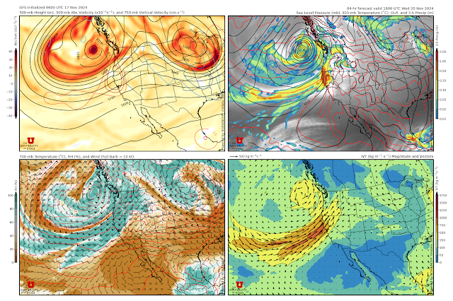
The IVT associated with this system is high, but not exceptionally strong.  In the forecast above it tops out between 750 and 1000 kg/m/s, whereas extreme values can reach over 1500 kg/m/s.  However, due to the high-amplitude nature of the flow, this is a slow moving system, so the AR will be pointed at that area for a long time.  The Center for Western Weather and Water Extremes (C3WE) has created an AR scale to rate the intensity of atmospheric rivers and their impacts that considers both the strength and persistence of high IVT.  On a scale of 1-5, this one rates a 4 on the coast of northern California based on the control run of the Global Ensemble Forecast System (GEFS), another model used for weather prediction.

By now you are probably wondering what all this means for Utah.  It probably means a bit of a break after the weak system that moves through on Monday.  After that system, we look to be to the south of the AR, in an area that is relatively dry.  As a result, the Utah Snow Ensemble plume for Alta-Collins shows a bit of snow around 0000 UTC 19 November (5 PM MST Monday), and then 3 days of what looks to be dry weather.  After that, there is a wide range of possibilities.  

To summarize, the next few days will provide an example of how Mother Nature can break the jet stream and produce a high-amplitude flow pattern, explosive cyclogenesis, and high impact weather.  I'd say buckle up, but Utah is not in the crosshairs, at least for the next few days.

Sunday, March 17, 2024

Sastrugi

Along with graupel, sastrugi is one of my favorite weather-related words and I saw plenty of it ski touring yesterday.  

Sastrugi is defined by avalanche.org as "heavily wind eroded snow with wavy textures." Sometimes it looks rough or pockety.  In the photo below, it appears there is avalanche debris on this slope, but in reality it is all sastrugi.  

In some areas, the sastrugi was dense wind board and generally supportive of a skier. 

In others, it was actually somewhat soft and didn't ski to bad on the descent. Each turn was a mystery!

Although I like sastrugi as a word, it's not my favorite snow surface to ski.  We can blame the sastrugi in this case on the multiday easterly wind event that has been affecting the Wasatch Range and Front since Thursday.  Observations from Alta's Mt. Baldy show the winds veering (turning clockwise) from southwesterly just prior to 1200 MCT 12 March (Tuesday) to north by 0000 MDT 14 March and then locking in with easterly flow with gusts reaching over 50 mph on the 15th (Friday) when most of the damage was done. 

The large-scale setup for these winds was something that meteorologists call anticyclonic wave breaking in which a high-amplitude ridge develops in the high latitudes and leads to the formation of a closed low downstream and to the south.  Below is the GFS analysis for 1200 UTC 15 March during the period of stronger easterly flow on Mt. Baldy.  Note the ridge off the Pacific Northwest coast and the deep closed low centered along the CA-MX border, resulting in strong easterly 700-mb (crest-level) flow over the Wasatch. 


This is the same pattern that produced heavy snowfall along the Colorado Front Range. Basically, this is a complete reversal of the climatological westerlies.  They get upslope and we get downslope.  

The pattern has been very persistent and this morning enhanced easterlies ares still being observed along the east bench of the Salt Lake Valley north of Holladay, although they are weaker than at the peak.  

Wednesday, June 23, 2021

A Concerning Cool Down, Then More Pain and Agony

A weak short-wave trough and moisture surge moving into northern Utah later today will bring cooler temperatures and a threat of a few showers and thunderstorms tomorrow.  The likelihood increases through tomorrow with isolated T-storms later today, scattered tonight, and showers likely tomorrow.  

The NAM forecast valid at 1500 UTC (9 AM MDT) tomorrow morning shows the short wave trough and associated clouds and precipitation over central Utah.

This isn't a major monsoon surge, so it won't be a drought buster, event if you happen to get a good downpour wherever you are.  The concerning part of the cool down is that while we will get some precipitation, there will also be dry thunderstorms, which are thunderstorms that produce lightning, but little to no precipitation.  Enjoy the modest cool down, but hope that we don't see many if any fire starts.  

The extended model forecasts are putting an enormous ridge over the Pacific Northwest and southwest Canada.  Below is an example from the GFS valid 0000 UTC 28 June (6 PM MDT Sunday).  

This has the potential to bring historic heat for this time of year to portions of the Northwest.  It is likely that we will see a return to near or above 100˚F next week too.  

What can I say?  Despite short-term cooling, the long-term trend is not our friend.

Sunday, September 23, 2012

A Fly in the Ointment

A high-amplitude upper-level ridge remains parked over western North America, but as shown in yesterday afternoon's 0000 UTC 23 Sep 500-mb height analysis, there is a potential fly in the ointment for Utah weather.

Source: NOAA/ESRL
The fly is the weak closed low that is sitting over the coast of Washington, which results from a weather feature that meteorologists call a coherent tropopause disturbance, or CTD.  A CTD is a localized cyclonic vortex, which is associated with counterclockwise rotation in the Northern Hemisphere and is strongest at the tropopause.  The tropopause separates the stratosphere from the troposphere.

Source: NASA
The CTD and closed low move into Nevada by tomorrow morning [1200 UTC (0600 MDT) 24 September].


A different perspective at this time is provided below by a 3-D colored representation of the tropopause, with cool colors indicating a lower tropopause and warm colors indicating a higher tropopause.  Note how the tropopause is locally depressed where the CTD and closed low are found over Nevada.


Next, we have a vertical slice taken through the CTD the line that bisects the image above.  In this slice, the tropopause is indicated by a red line.  Note how the tropopause is locally low just left of center where the vertical slice cuts through the CTD.  


The other lines are temperature contours.  Note how they dip down near and beneath the CTD, which is an indication of colder air aloft.  

Thus, as the CTD approaches Utah, temperatures in the upper-troposphere will fall.  This, combined with large-scale rising motion ahead of the CTD, will act to destabilize the atmosphere and initiate some showers and thunderstorms.  As a result, although we are still under the influence of a large-scale upper-level ridge, we have a chance of some isolated showers and thunderstorms today and scattered showers and thunderstorms tomorrow.