A major transition in the structure of the jet stream will occur over the next few days, resulting in the development of an omega block over the Norh Pacific Basin and high-impact weather for northern California and the Northwest United States.
The plot below is a combined sea level pressure (black contours) and dynamic tropopause (jet-stream level) forecast for 0000 UTC 18 November (5 PM MST Sunday). I have identified the jet stream over the North Pacific Basin and North America with a black line. The forecast shows a deep low pressure system over the Sea of Okhutsk (at the tip of the L1 arrow). Downstream of it, there is strong southerly flow at the surface. L1 and the strong southerly flow ahead of it don't look at that disruptive, but combined with warming due to condensation in the precipitation system accompanying them (not shown), they serve as the proverbial straw that break's the camel's back.
By 0900 UTC 19 November (2 AM MST Tuesday), L1 has weakened, but the ridge downstream of it has amplified substantially. Concurrently, the surface high pressure system, H1, has also amplified. This is an example of the mutual amplification of an upper-level ridge and surface high pressure system. However, that's not all that is going on. The trough downstream of that ridge is also amplifying, and another low pressure system, L2, is starting to develop over the eastern Pacific. By 0000 UTC 20 November (5 PM MST Tuesday), the jet stream pattern over the Pacific Basin is highly amplified (call it wavy if you want) and L2 has turned into a monster as it and its accompanying upper-level trough mutually amplify. L2 is what we call an explosively deepening cyclone, or bomb because its sea level pressure drops so fast. Before numerical weather prediction and our ability to anticipate explosively deepening cyclones, such a storm would have been a shipwrecker, coming out of nowhere to produce dangerous winds and seas that are a marine nightmare. Today, we know it is coming, but it will still be a beast.Finally, by 1800 UTC 20 November (11 AM MST Wednesday), the omega pattern is fully developed with the high-latitude ridge and mid-latitude troughs forming a clear "omega" pattern covering the North Pacific Basin. This "breaking" of the jet stream results from the progressive amplification of a series of upper-level ridges and troughs (and accompanying surface high and low pressure systems) through a process called downstream development. The end result is a high-amplitude flow pattern and in many cases high-impact weather.
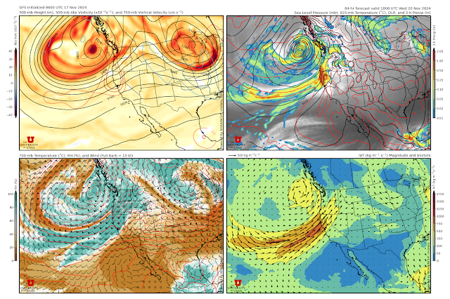
In this case, the high impact weather is in the form of L2, an explosively deepening cyclone, and it's accompanying atmospheric river, which looks to bring heavy rainfall to portions of northern California and the Pacific Northwest. Looking at the GFS forecast for 1800 UTC 20 November (11 AM MST Wednesday) shows L1 off the coast of Washington and British Columbia (upper right panel in the figure below), but the accompanying atmospheric river, identified by the high integrated vapor transport (IVT) values in the lower right plot below, is aimed straight at northern California. This is a flow configuration that can produce heavy rainfall in the coastal mountains and southern Cascades.


No comments:
Post a Comment