Saturday, June 29, 2013

History Strikes Twice

For the second day in a row, we have hit a maximum temperature of 105ºF at Salt Lake City airport.  Never before observed in June, we've now done it twice.

Source: NWS
It is becoming increasingly apparent that this has the potential to be a historic heat wave.  Arguably, with two 105s in June, we are already there, but the GFS continues to keep a very high amplitude ridge over us through the next week.  Below is the forecast for next Saturday afternoon.


The 700-mb temperature in that forecast is 20.5ºC, which would be an all-time record.  It's too soon to say that will verify, but I mention it to indicate that the triple digits could be around for a while.  We have to hope that a short-wave trough somehow clips us or that we get some airmass thunderstorms going to avoid 100.

Thus, head to the hills or, if that is not possible, stare at the photo below and think cool thoughts.

Friday, June 28, 2013

Records Fall

It appears that today's maximum temperature at the Salt Lake City airport was 105ºF, which is a record for the day and I believe the all-time record for June.

Source: NWS
Let me see if I can cool you off with some Alaskan weather.  There's probably no place in the world that offers the combination of mountain and marine meteorology like Southeast Alaska.  With the Mendenhall Glacier as a backdrop, we gawked this morning at a stable marine boundary layer with fog.  Those with careful eyes will notice evidence of shear-induced turbulence at the top of the fog layer, which was likely related to thermally driven gap flow into Gastineau Channel.


Yup, it's a world away from Utah.

Thursday, June 27, 2013

Quick and Dirty Heat Wave Forecasting

A quick-and-dirty way to forecast summertime maximum temperatures in Salt Lake City during situations where there are gradual changes in the airmass is to simply adjust the forecast based on the model-predicted temperature change at 700-mb.

Here's how it works.  Let's start with yesterday's observed 700-mb and maximum temperatures at the Salt Lake City airport.

5 PM 700-mb temperature: 13.8ºC/56.8ºF
Maximum temperature: 34.4ºC/94ºF
Differential: 20.6ºC/37.2ºF

Next, take the model late afternoon 700-mb temperature forecasts for the next few days and estimate the maximum temperature based on the differential above.

Thursday (today):
NAM 700-mb temperature: 16.6ºC
Estimated Max temperature: 37.2ºC/99.0ºF
GFS 700-mb temperature: 17.4ºC
Estimated Max temperature 38ºC/100.4ºF

Friday:
NAM 700-mb temperature: 17.9ºC
Estimated Max temperature: 38.5ºC/101.3ºF
GFS 700-mb temperature: 18.3ºC
Estimated Max temperature: 38.9ºC/102.0ºF

Saturday:
NAM 700-mb temperature: 19.5ºC
Estimated Max temperature: 40.1ºC/104.2ºF
GFS 700-mb temperature: 19.4ºC
Estimated Max temperature: 40.0ºC/104.0ºF

Sunday:
No NAM forecast available
GFS 700-mb temperature: 19.3ºC
Estimated Max temperature: 39.9ºC/103.8ºF

There are some permutations to this approach.  One is to adjust based on the average differential over several days rather than just one.  This works well if you've been in a fairly persistent pattern as it smooths out some of the spikiness that exists in temperature observations.  Another is to account for the model bias.  Most models have a small bias (e.g., model A tends to be a bit too warm) and it can be helpful to correct for this too, if it is known (often, it isn't, as the weather is quite variable so you don't always know the bias for a specific situation).  Those willing to write code can use a Kalman Filter or other statistical approaches to do these sorts of adjustments in automated fashion.  

The pitfall to the quick-and-dirty approach above is that even though the large-scale airmass might not be changing much, small variations in the weather could play a role.  For instance, there could be a subtle flow shift that occurs so that the Great Salt Lake has a greater influence on the maximum temperature than it has had previously.  Or, just enough moisture creeps in that convection begins to pop up.

In any event, it appears nuclear summer is here.  Heading for high ground is recommended.  I'm actually going to lower ground—Juneau, Alaska.  Forecast high for today: 59ºF.  So long suckers....

Wednesday, June 26, 2013

Dry and Hot

I'm back in town after a quick trip to Boulder and the National Center for Atmospheric Research.  Apparently I missed out on the "big" precipitation event, which gave us a trace of rain Monday at the Salt Lake City International Airport.  That may have ended our stream of days without precipitation, but the streak of days without measurable precipitation continues.

Source: NWS
There is a very real chance that we will make it through June without measurable precipitation.  Only a rogue convective storm could ruin that streak.

We are now about to enter what should be a hot stretch.  We mentioned a few days ago that the GFS was going for extremely warm temperatures for later this week, with forecast 700-mb temperatures near 20ºC, which is on the outer edge of our current climatology (I emphasize current because higher temperatures are coming in future decades).  The good news is that the latest forecast are slightly cooler, putting the 700-mb temperature for Friday afternoon near 18–19ºC, but the bad news is that's still damn hot.

I mentioned in that earlier post that days with 700-mb temperatures near or above 20ºC are very rare (note: we use 700-mb, which is at about 10,000 feet, as an indicator of the overall warmth of the airmass).  Trevor Alcott of the National Weather Service recently sent me some numbers illustrating that this is truly the case.  In fact, days above 19ºC are pretty exceptional, as can be inferred from the 10 highest 700-mb temperatures observed at the Salt Lake City airport since 1956.

Courtesy Trevor Alcott
Here are the peak 700-mb temperatures forecast by the GFS for the approximate time of the upper-air soundings on Friday, Saturday, Sunday, and Monday afternoons:

Friday: 18.2ºC
Saturday: 19.1ºC
Sunday: 19.5ºC
Monday: 19.2ºC

Yup, that's rarified air, probably good for maximum temperatures at the airport in the triple digits.  Nasty!  In addition, I need to note that this is JUNE (Monday is July), and all the top-10s above are in July and August.  So, this is especially rarified air for this early in the year.  We'll have to keep an eye on things to see if we can break into the top-10 for all-time 700-mb temperature.  If you are keeping score at the ground, the records at the airport for Friday Saturday, and Sunday, are 102, 104, and 103, respectively.  

Monday, June 24, 2013

Big Moon Facts and Fictions

Minor edits have been made to this post to make some important clarifications as suggested by commenter Tommy T below.  

Moonset this morning over the Boulder Flatirons.  Sponsored by Bud Light.
I've been enjoying the hype and hyperbole over the Big Moon the past few days.  It's a wonder that we all haven't gone werewolf (well, perhaps some of you have).  There is both fact and fiction at play here.

The moon's orbit is elliptical and thus not quite circular.  Although the average distance to the moon is about 385,000 km, at perigee, when it is closest, it is about 365,000 km away, whereas at apogee, when it is farthest, it is about 405,000 km away.    

There is no doubt that this causes a change in the apparent size of the moon.  The solid angle subtended by the moon varies from about .56º at perigee to about .49º at apogee.  This does make the size of the moon seem to vary.  The moon subtends a larger solid angle and appears larger at perigee than it does at other points in it's orbital cycle.  

However, there is another trick at play here and that is something called the Moon Illusion.  When we observe moonrise, the moon often appears much larger than it does when it is near zenith (it's highest point in the sky).  This is not because the moon is closer at moonrise than at zenith, but instead because the presence of nearby objects affects our brain's interpretation of the scene.  The precise cause of this illusion is actually a subject of debate, but most of the photos I've seen of the Supermoon have this as an exaggerating factor.  

Sunday, June 23, 2013

20/20 Rule May Be Invoked

I have this simple "rule" for recognizing when the atmosphere is going into big-time outlier mode over Salt Lake City and I call it the 20/20 rule.  Situations in which the 700-mb (roughly crest level) are less than –20ºC or more than +20ºC are rare and on the outer edge of the distribution of temperatures we observe over Salt Lake City.

The latest GFS forecast suggest that we will flirt with the +20 later this week, putting the +20 contour somewhere between Provo and Salt Lake on Friday afternoon.


The record high for that day is 102ºF and if this forecast holds up we may make a run at that, possibly exceeding it if the southerly flow can get going.  This is still a 5 1/2 day forecast, so no point in getting to excited (or depressed) yet, but it appears we may be in for a scorcher.

Saturday, June 22, 2013

Heaven then Hell

By any measure today is simply heavenly.  What a treat to have such weather in late June.

The University of Utah from the "Living Room"
Unfortunately, the forecast suggest that Hell will be paying us a visit with a massive upper-level ridge progged to develop over the western US late next week.  It's still a ways out, but it has that heat wave look.


Between now and then, the $64,000 question is can we get some precip out of the short-wave trough that glances by Monday night and Tuesday.  It appears to be our only hope for rain at the airport this month.  My money is on a rainless June.

Friday, June 21, 2013

Potential for Rare California Rain

Most of California is characterized by a Mediterranean climate with extremely dry summers.  Even northern California is typically dry.  Here is the average precipitation (inches) for June, July, and August at selected cities in the northern part of the state (courtesy Western Region Climate Center).

Eureka: .68, .15, .32
Redding: .79, .10, .15
San Francisco: .13, .02, .04
Sacramento: .18, .03, .06

So, summer rain is rare, especially as one approaches July.

The latest forecasts, however, suggest that northern California might be getting some over the next few days with a storm coming in for Sunday through at least Tuesday.  The GFS in particular calls for >1.5 inches along much of the California coast north of San Francisco and mountain accumulations of several inches.


Bigfoot will be surprised!

Thursday, June 20, 2013

A Lack of Moisture

My friends of Meteorological Solutions Inc. sent me some remarkable observations taken near Milford, Utah yesterday.  It is hard to imagine a lower atmosphere completely devoid of water vapor, but yesterday in Milford is probably as close as you can get.  The observations taken ~1700 MDT (2300 UTC) show an hourly average temperature of 82.6ºF/28.1ºC and a Relative Humidity of 0.427%, yielding a dewpoint of -42.3ºF/-41.3ºC and a dewpoint depression of 125ºF/69.4ºC.

That's the big 125 in Fahrenheit!  I don't have an encyclopedic memory, but good luck finding something bigger than that.  Maybe in the central Sahara, the Empty Quarter, or Death Valley?  Incredible.

Wednesday, June 19, 2013

Flirting with June Gloom

In the far Pacific Northwest they call it the June Gloom, the seemingly never ending extension of the rainy season into June.  Places like Portland and Seattle are typically heavenly (dry and mild) in July and August, but that gorgeous weather always seems to take forever to arrive.  Over the next week, I suspect that northwesterners will be pulling their hair out.  The GFS pretty much keeps them in an active storm track, resulting in frequent periods of rain and forecast accumulations approaching four inches in places.

Source: NCEP
Those are healthy accumulations when you consider that the GFS doesn't fully resolve the mountains and their influence on precipitation.  Unfortunately, Utah remains on the edge of the storm track, with no precipitation forecast.  We only flirt with the June gloom, which is too bad as a good soaker would be appreciated here.  Let's hope the storm track dips a bit further south than progged.

Tuesday, June 18, 2013

We Are in Outlier Mode

There's some wild weather to be found in western North America thanks to a jet stream that is in outlier mode.

The dynamic tropopause (jet level) analysis for 6 PM MDT yesterday afternoon shows a high amplitude upper-level ridge over Alaska, a short-wave trough over the Yukon, and a closed upper-level low off of the Pacific Northwest coast.


The impact of the Alaska–Yukon ridge-trough system on the weather of parts of Alaska is astounding.  How about a maximum temperature of 90ºF in Valdez yesterday.  How crazy is that?  Their previous record high for the day was 75ºF.  It also broke their all-time record high of 87ºF.  Have a read of the rather enthusiastic record event summary from the National Weather Service.  


Meanwhile, ahead of the closed low off the Pacific Northwest coast, Utah is mired in fire-weather hell. How about these observations from Milford yesterday where at 3:52 PM MDT they reported a temperature of 90ºF and a dewpoint of -18ºF for a dewpoint depression of 108ºF and a relative humidity of 1%. 


It will be even hotter today, although we are due for a cool down beginning tomorrow.  The cause of that cool down is the migration of the closed low off the Pacific Northwest coast into the northwest interior.  Yeah, it was hot in Alaska, but how about some freshies for Glacier National Park?  Looks like a good possibility for tomorrow night and Thursday.


Yup, Mother Nature giveth, and Mother Nature taketh away.  Weird weather happens when the atmosphere is in outlier mode.  

Saturday, June 15, 2013

Lessons in Buoyancy at the Spiral Jetty


If you have never taken a trip to the northern Great Salt Lake (a.k.a. Gunnison Bay), do it.  It is a spectacular place, far removed from the hustle and bustle of Salt Lake City.  We made a trip to the Spiral Jetty today and had a great day enjoying the swimming and the sites.

The Spiral Jetty was built by Robert Smithson in 1970
Yeah, that's right, the swimming.  Or, better put, floating as we forgot goggles and the last thing you want to do is get that water in your eyes.  Many people have floated around at Saltair and Antelope Island, which is all fine and dandy, but the salinity in that half of the lake (a.k.a. Gilbert Bay) is "only" about 10–12%, whereas in the north half is usually near 28%.  Ocean water is about 3.5%.

Source: USGS
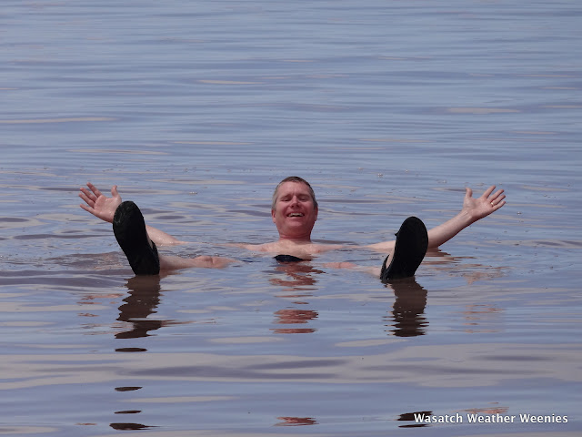
So, if you really want to bob like a cork, the north arm is the place to do it.  In fact, a float in the north arm is a great lesson in buoyancy, as I discovered today.


I can't hold a pose like that in freshwater, but it's a piece of cake in the northern Great Salt Lake.  This is an example of Archimedes's principle.  The upward force exerted on a body, even one as decayed as mine, equals the weight of the fluid displaced.  Salty water is denser than freshwater, so you don't have to displace as much fluid to balance your weight and you bob higher relative to the water line.  You could do an experiment by taking a day trip to float in Utah Lake, the southern Great Salt Lake, and the northern Great Salt Lake and you'd surely find the worst buoyancy in Utah Lake and the best buoyancy in the northern Great Salt Lake.  Use a toy boat and mark the water line at each site and you'll have clear evidence of Achimedes's principle in action.

Why is the northern Great Salt Lake so salty?  An earthen railroad causeway was built across the center of the Great Salt Lake circa 1960.  There are only a couple of small gaps in this causeway, so there is very little mixing of water between the two halves.  Most of the freshwater inflow comes into the southern half, which dilutes the water.  In contrast, the northern half has little freshwater inflow and is heavily enriched with minerals.

The impact of the construction of the causeway can clearly be seen in the USGS salinity data graphed below.  Note how there was a temporary decrease in salinity in the northern half of the Great Salt Lake (Gunnison Bay) during the huge snow and runoff years of the 1980s, but it still remained substantially higher than that found in the southern half (Gilbert Bay).

Source: USGS
If you want to visit Spiral Jetty and have a look and float for yourself, there is a nice description here.  The road is in excellent condition and is now passable by passenger vehicles around Rozell Point all the way to the Jetty.

Friday, June 14, 2013

Breath Deep

We have reached that time of year when you have to take a few moments to appreciate any cool airmass that pushes into the state.  With a forecast high of only 77ºF at the Salt Lake City Airport, sip and enjoy every breath.  If you can get out for a hike or ride, do it.  The models hint that we might get another cool down later next week, but July is coming and the dog days of summer will be here soon enough.

The hot weather the past several weeks has helped us catch up on where we stand thusfar this year relative to the average climate for the 20th century.  Recall that the statewide annually averaged temperature for Utah has not been below the 20th century average since 1993, and that last year was the hottest in the instrumented record.

Utah's statewide average temperature departure from
the 20th century average.  Source: NCDC
I frequently comment that it is unlikely that we will ever again see a year with a statewide average temperature below the 20th century average, but I was getting pretty nervous in March when we were running cold.  Well, we've made up quite a bit of ground in recent weeks.  We're still 1.5ºF below average for the January–May period, but that's close enough that it can be made up in the coming months.

Source: NCDC
Time will tell where we end up, but I think it's likely than not we will come out in the red again.

Thursday, June 13, 2013

More Wild Wind

A cold frontal passage has ushered in some cooler air, but has been accompanied by some very strong winds.  Here are a few of the peak gusts thusfar from around the area:

  • Flight Park (near point of the mountain): 72 mph
  • Saratoga Springs: 68 mph
  • Lehi: 59 mph
  • Point of the Mountain: 57 mph
  • Highland: 54 mph
  • Antelope Island: 53 mph
  • Pleasant Grove: 51 mph
  • Orem: 50 mph

The Microburst

Schematic of the Traveling Microburst (Fujita 1981)
Yesterday evening I was working on my computer at home when the Emergency Broadcast System alarm went off on the TV in the adjoining room.  It really got my attention since I wasn't expecting much in the way of severe weather, so I thought it was either an Amber alert or perhaps something more serious.  I walked over to where I could see the TV and noticed it was a severe thunderstorm warning issued for Salt Lake and Davis County.

The culprit was a microburst, a localized downburst that produces strong straight line winds at the ground as depicted above.  The one we had last night was an example of a dry microburst as most of the precipitation that generated it evaporated before reaching the ground.  Some meteorologists differentiate between microbursts and macrobursts depending on the size of the area affected.  Indeed, this event may have had macroburst scale, but we will stick with microburst for this discussion.  

Dry microbursts are typically generated in Utah by high based storms.  Precipitation falling from these storms falls into the dry low-level airmass and evaporates, with the resulting cooling generating an area of locally cool, dense air that sinks very rapidly towards the ground.  Environmental conditions were ripe for microburst generation last night with an extremely deep, dry boundary layer extending from the surface to near 500 mb.


Meteorologists use a variable known as Downward Convective Available Potential Energy (DCAPE) to assess the potential strength of downdrafts and downbursts.  Last night, the DCAPE was 1684 joules/kg, which is a very high value indicating the potential for downburst-related strong winds.  What was needed was some precipitation to get things going. 

The curious thing about last nights storm is that it barely showed up on the lowest elevation radar scan that we normally use to examine precipitation (especially in the winter).  It was best picked up by the so-called "third tilt", which is at 1.3º relative to the local horizon.  Even still, the storm was pretty unimpressive with relatively weak radar reflectivities.  


But, the key here was the evaporation of that light precipitation into the dry airmass.  And, it led to very strong winds.  Here are  some storm reports issued by the NWS, which include a 75 mph wind gust.  I saw one house on the news with a very large tree on it.  The residents of that home were very fortunate that it was well constructed!

Finally, we have a video, courtesy George Wilkerson and Steve Krueger, of the microburst rampaging through the Salt Lake Valley.  Keep an eye on the lower left hand corner.   And it will eventually appear.

Wednesday, June 12, 2013

A More Difficult 100

Black Forest Fire.  Source: Colorado Springs Gazette
Wildland fire is raging once again near Colorado Springs.  El Paso County Sheriff Terry Maketa reported at 9 am this morning that at least 80 homes have burned in the Black Forest Fire, with over 7,000 homes evacuated.   

The wildfire ran more than 8 miles yesterday.  Atmospheric conditions were simply atrocious.  At the Colorado Springs Airport, temperatures yesterday afternoon reached the high 90s.  


That's bad, but the air was unbelievably dry.  At 3 PM MDT, it was 96ºF with a dewpoint of -4ºF.  That yields a dewpoint depression (the difference between the temperature and the dewpoint) of 100ºF and a relative humidity of 2%.  It doesn't get any drier than that (well, it could, but not by much).  

Winds during that period were also gusting to more than 30 miles per hour, although they reached as high as 44 miles per hour just a couple of hours earlier.  


That's pretty much a worst-case scenario for fire weather conditions.  

Tuesday, June 11, 2013

An Early Festivus

Source: www.tumblr.com
In the wake of the busting of my forecast for yesterday (see previous post) and the attainment of 100ºF at the Salt Lake City airport, the Wasatch Weather Weenies will be celebrating an early Festivus and airing our grievances today.  

Mainly I just want to belly ache about my blown forecast.  In forecast contests, I have certainly taken advantage of the tendency for the Salt Lake City International Airport (KSLC) observing site to go crazy warm in strong southerly flow, but yesterday's 100ºF was ridiculous.  I still don't believe it!  The afternoon sounding shows a convective boundary layer that extends all the way to 500 mb and a super adiabatic layer near the surface where the temperature was 96ºF.  

Source: NOAA/NWS/SPC
Such a layer is absolutely unstable and difficult to maintain.  Thus, getting a few more degrees out of such as sounding is difficult, especially when the winds are strong.  Yet it happened yesterday at the airport.  Curses.  Two laps around the Festivus pole.  

Because of this Festivus celebration, I am introducing a new subject tag for Wasatch Weather Weenies posts: Belly Aching.  We will try to keep these to a minimum, but such activities are part of every meteorologists repertoire, especially mine.  

Sunday, June 9, 2013

The Timing Is Wrong

Forecasts that I've seen on the news and in the media the past couple of days have been hinting that we would hit the big 100 on Monday.  It's going to be hot today and tomorrow, but it looks to me like the timing might be wrong to get to the triple digits.

The problem is this.  There is a tongue of very warm air forecast to move across Utah late today and tonight in advance of a closed low that is approaching Utah from the southwest.  The warm tongue is forecast to extend across southern and central Utah by 6 PM MST this afternoon.


As a result, Salt Lake is not in the heart of the warm air this afternoon and our 700-mb temperatures only make it to about +15 or +16ºC.  That's unseasonably warm and good enough for temperatures in the low to mid 90s, but not enough for the big 100.

The warm tongue then moves over us late this evening and tonight.  By mid-day tomorrow, cooler air (cooler being relative here!) associated with the closed low is already starting to move in and 700-mb temperatures are dropping.  By noon tomorrow, they are already back to +15ºC again.  


Timing is everything.  In this case, it appears we'll just miss out on the phasing of the warmest airmass and afternoon heating needed to get to 100.  Of course there's always "hope" that the models are wrong.  Hope here being purely for the psyche factor of 100.  The mid and high 80s are far more desirable.

Thursday, June 6, 2013

An Opportunity to Revolutionize Air Quality Monitoring in Utah

During this past winter, we discussed how desperately we need more comprehensive air quality monitoring in the Salt Lake Valley.  Well, there is an article this week in the New York Times about efforts to sample and map air quality in New York that provides a glimpse of what could be done in Salt Lake City.  Be sure to check out the video.

The basic idea is to couple an air quality monitor with a smart phone and them map the data on a web site.  Imagine the quantity and density of observations that could be collected in the Salt Lake Valley (outdoor and indoor) in this fashion.  It is a little unclear from the video and the article precisely what can currently be measured, but the Aircasting web site suggests carbon monoxide and nitrogen dioxide.  The video suggests they can measure particulate matter too (perhaps this is inferred based on the correlation between carbon monoxide and particulate matter).  In any event, any of these measurements are useful.

Source: aircasting.org
We need a system like this operating during inversions in the Salt Lake Valley and throughout the Wasatch Front.  We would have unprecedented information about the air quality in the valley.  Further, this is essentially "shovel-ready" project.  All that is needed are some enterprising individuals and some motivated groups or individuals to provide support.  This is a citizen science project that truly has the potential to revolutionize our knowledge and understanding of a major environmental and health challenge facing the Wasatch Front.  Someone out there should make it happen.

Addendum, 7:15 AM 7 June: I realized after hastily writing this last night that I probably should dig a little deeper.  Information on the air monitor and how to build one is here.  Additionally, there are accuracy, sampling, and calibration issues that need to be addressed, so "shovel-ready" might have been overly optimistic.  Nevertheless, I do see this as an example of what could be done along the Wasatch Front.

A Diverse Pattern

There's a lot to love in the latest satellite loop for North America:

  • Ridging over the western US with some afternoon convection mainly over the high terrain
  • A Mesoscale Convective System (MCS) forming from convection over the high terrain of New Mexico and the flatlands of central Texas that drifts eastward to the Texarkana area (I've always wanted to say Texarkana!).
  • Tropical Storm Andrea making landfall in what I'll call the Bight of Florida.  
  • And, way up in the upper right hand corner, one can find an extratropical cyclone that is bringing some snow to NewFoundland and Labrador.  


Yup, there's something here for just about everyone except perhaps severe convection aficionados, although there is a tornado watch in place for much of Florida due to the effects of Andrea.

Wednesday, June 5, 2013

Parallels between Storm Chasing and Backcountry Skiing

There has been considerable coverage the past few days of the unfortunate deaths of Tim Samaras, Paul Samaras, and Carl Young in the El Reno, Oklahoma tornado on Friday.  This post is not to comment on that incident, which to my knowledge has yet to be fully investigated.  Instead, I wish to draw some parallels between storm chasing and backcountry skiing as I wonder if the two groups might be able to learn from each other.

Like the backcountry ski community of Utah, a wide range of individuals participate in storm chasing.  These individuals include (but are not limited to) research meteorologists using mobile radars and other instruments to try and better understand tornado dynamics and processes, volunteers attempting to provide ground truth for weather warnings and their verification, professional storm chasers taking photos and videos for resale, people on guided tours (yes, they do that!), and folks just out for fun.  You can draw a parallel to the Utah backcountry ski community, which consists of snow-safety professionals, pro skiers and photographers, guided tour groups, and folks just out for fun.

A remarkably large number of people can be out storm chasing.  The YouTube video below (by Whacky Rat) shows the approximate positions of the El Reno tornado and the various storm chasers.


Like the Utah backcountry ski community, the knowledge and experience of the storm chasing community varies.  There are people with severe storm expertise and storm-chasing experience, people with  severe storm expertise but limited storm-chasing experience, people with limited severe storm expertise but considerable storm-chasing experience, and people with limited severe storm expertise and limited storm-chasing experience.

There is a tendency for the public and the media to equate knowledge and experience with safety, but human factors have been shown to contribute to most avalanche accidents, which have claimed individuals ranging from inexperienced to the highly experienced in snow safety practices.  As Ian McCammon wrote in his 2002 ISSW paper Evidence of Heuristic Traps in Recreational Avalanche Accidents, "Even though people are capable of making decisions in a thorough and methodical way, it appears most of the time they don't."  As the saying goes, most avalanche accidents happen by choice, not chance.

The problem is that human factors complicate thorough and methodical decision making, even by experts.  In backcountry skiing, these human factors include powder fever, group think (it is well documented that larger groups inhibit the sharing of information and concerns), expert halo (deferring concerns because of the presence of a more experience group member or guide), overconfidence, peer pressure, occupational pressure, Kodak courage, and familiarity (I've skied this run a hundred times in conditions like this, so let's ski it today).

I have a very limited experience as a storm chaser [I prefer storm chasing Utah style (i.e., for powder)], but see a strong parallel with backcountry skiing.  The human factors noted above (use irrational exuberance as a generic substitute for powder fever) complicate decision making an all sorts of situations.  I'm not sure how strong the parallels are between storm chasing and backcountry skiing, but perhaps there is something that the two groups can learn from each other, including in the area of education.

Tuesday, June 4, 2013

The Dry Season Begins

Lush grass and gardens in the Avenues at the start of June.
There is no official start of the dry season, but June 1st serves as a reasonable demarkation as June, July, and August are the only months that average less than an inch of rain at the Salt Lake City International Airport.

We head into the dry season with the valley looking lush (by Utah standards).   It's actually quite remarkable how green everything is given that May brought only 1.26 inches of rain to the Salt Lake City Airport, compared to an average of 1.95 inches.  That rain, however, was fairly well distributed with .54 inches falling from May 17–20 and then .63 inches falling from May 28–29.  

That's the good news.  The bad news is that our spring runoff is already almost over.  Most SNOTEL stations have no snow (white squares) or less than 25% of average snowpack snow-water equivalent (SWE, dark red squares) for early June.  The only site at more than 50% of average is Lakefork Basin in the Uintas, which sits at 71%.

Source: NWS/CBRFC
The Snowbird SNOTEL has been dropping like a rock through May and it looks like it will bottom out  by tomorrow.  That would be 12 days ahead of the median day of snow cover loss and well ahead of average.

Source: NWS/CBRFC
For the second year in a row, we're going to be leaning heavily on the storage in our reservoir system.  

Monday, June 3, 2013

Looking for Photos

I'm looking for photos for a mountain weather book that I am working on.  It's embarrassing to admit that I don't have anything of these in my own library, but I don't.

  1. Iconic photo of deep snowpack at Mt. Baker during world record 1998/99 season
  2. Close-up photo of a graupel particle
  3. Photo or series of photos showing a cloud undergoing glaciation
  4. Photo of extreme rime on lift towers, buildings, trees, etc. 
  5. Photo of interlodge sign at Alta
  6. Photo of Alta buried immediately following the end of interlodge
  7. Photo of the untracked or lightly tracked sidecountry north of Snowbasin from the resort - something that shows the "lure" of powder.  
If you have anything that might work, send it to me in an e-mail: jim.steenburgh-at-gmail.com and we'll see if it will do the job.  This is a low budget project, so I can promise fame but not fortune!

Sunday, June 2, 2013

A Green City Creek Canyon


There are just a few patches of snow in the upper basin, which are nearly impossible to discern in this photo.  Yeah, this is June 2nd!  I'm guessing we won't be getting much water from this canyon this year.

Saturday, June 1, 2013

Weather, Utah, and Springsteen's Promised Land

The cover of Bruce Springsteen's compilation album The Promise
was taken by photographer Eric Meola in Utah in 1977.
Columbia Records 
Bruce Springsteen hasn't written much about Utah, but it is featured prominently in The Promised Land on his album Darkness on the Edge of Town (even if there is no Waynesboro county in Utah).
On a rattlesnake speedway in the Utah desert
I pick up my money and head back into town
Driving cross the Waynesboro county line
I got the radio on and I'm just killing time
Working all day in my daddy's garage
Driving all night, chasing some mirage
Pretty soon little girl I'm gonna take charge.

The dogs on main street howl,
'cause they understand,
If I could take one moment into my hands
Mister, I ain't a boy, no, I'm a man,
And I believe in a promised land.

I've done my best to live the right way
I get up every morning and go to work each day
But your eyes go blind and your blood runs cold
Sometimes I feel so weak I just want to explode
Explode and tear this town apart
Take a knife and cut this pain from my heart
Find somebody itching for something to start

The dogs on main street howl,
'cause they understand,
If I could take one moment into my hands
Mister, I ain't a boy, no, I'm a man,
And I believe in a promised land.

There's a dark cloud rising from the desert floor
I packed my bags and I'm heading straight into the storm
Gonna be a twister to blow everything down
That ain't got the faith to stand its ground
Blow away the dreams that tear you apart
Blow away the dreams that break your heart
Blow away the lies that leave you nothing but lost and brokenhearted

The dogs on main street howl,
'cause they understand,
If I could take one moment into my hands
Mister, I ain't a boy, no, I'm a man,
And I believe in a promised land
I believe in a promised land...
Peter Ames Carlin tells the story behind these lyrics and the photo on the 2010 compilation album The Promise in the 2012 Springsteen biography Bruce (p. 247), one of the better rock-related biographies that I've read.  Two days after hearing of Elvis' death, Springsteen, Steven Van Zandt, and Eric Meola flew to Salt Lake City and drove around non-stop for 30 hours on the desert backroads. At some point, a huge thunder and dust storm formed.  Meola called it a "Biblical storm" and it helped inspire a portion of the lyrics for The Promised Land.

I've been trying to figure out where the photo on the cover of The Promise was taken.  Comment if you have ideas.