Saturday, December 31, 2022

Storm Update

Storm total water equivalent as of 4 PM Saturday: 

Alta-Collins: 1.53"
Spruces: 1.24"
Ben Lomond: 3.5"
Snowbasin-Boardwalk: 1.81"
Brighton SNOTEL: 1.6"
Deer Valley Ontario: 0.88"
Sundance-Mid Mountain: 6.08"
Bunnels Ridge: 3.78"

So far, the storm has delivered as I might have expected in the southern Wasatch (Sundance, Bunnels ridge) and on Ben Lomond.  Elsewhere, we're running near or below expectations (so far).  In this case, that's probably a good thing.  As a meteorologist, you want your forecast to verify, but you can be happy when the hurricane comes onshore with impacts lower than expected.  I think that's the case here as it enabled us to go skiing, albeit in Sierra Cement rather than the Greatest Snow on Earth.  The ski touring was better than I expected, mainly because the high water content snow wasn't excessively deep.  

Speaking of water content, Alta-Collins automated observations suggest 14% at 9700 feet.  At lower elevations, water contents were certainly higher.  At about 7500 ft in Big Cottonwood Canyon, ski penetration was pretty limited due to both density and shallowness.  

There was, however, a fairly noticeable transition in snow density and wetness at about 8500 feet, which I suspect was close to the freezing level for much of the event (note that the snow level is below the freezing level, but melting typically results in wetter, higher density snow below the freezing level).  Still, the skiing was fun, although we found the snow to be somewhat inverted.  I suspect the joy of skiing today was a direct result of modern ski design.  I can't imagine that the 205s I used to ski in the backcountry back in the day would have done anything but dive.  Hooray for modern technology!

The models forecast this storm to continue until Sunday night or Monday.  When all is said and done, we will end up near or above 3.5" of water for the storm total at Alta-Collins.    

I may be taking a short blog break for a few days to recover.

Friday, December 30, 2022

Conflicted

I confess that I feel somewhat conflicted right now.  The backcountry riding has been really great since the last storm and it's a bit of a shame that we're going to submerge those sublime crystals with what is coming over the next few days.  Ideally we would have another day or two before another goldilocks storm, but instead we have a monster on the doorstep.  

The models continue to put out big numbers for this storm.  Our downscaled NAEFS product is putting 4 to 10 inches of water for Alta Collins through 12Z January 2nd (5 AM MST Monday), with an average of about 7 inches of water.  Note that today is just a minor appetizer.  Things pick up this evening and then continue for about 60 hours.  There could be a break or two in there, but expect big numbers. 


The high resolution HRRR is also going off.  The forecast below covers the period from 1800 UTC 30 December (11 AM Friday) through 1800 UTC 1 January (11 AM Sunday) and puts out 6+" of water for Timp, 5.8" for Alta, and 5+" for Ben Lomond and Powder Mountain. 

We've created a new HRRR-derived product for Little Cottonwood (available at https://www.inscc.utah.edu/~steenburgh/ml/hrrr_lccforecast.html) the version derived from the HRRR run above shows a predominantly warm 48-hour period through Sunday morning with Mt. Baldy temps warming tonight to near or above 20ºF where they remain for the forecast period.  The wet-bulb zero levels is near 8000 feet for a good chunk of the period.  


This means snow levels will rise today and tonight to perhaps 6500-7000 ft, with high-density snow at upper elevations.  I'm not sure the snow-to-liquid ratios will be as low as 5 at times, as suggested above, but I do expect this to be a high-density storm.  

The GFS is a low-end model.  The forecast below is from the a run initialized 6 hours before the HRRR forecast above, so it only goes through Sunday morning, but it similarly shows Mt. Baldy temps clibing to near 20˚F by this evening and periods where the wet-bulb zero level is 7500 feet or higher.  


The Euro is often a bit drier and for Alta is a bit under 3" for a storm total, although a gird point farther south is at about 3.77".  

The NWS cottonwoods forecast is due for an update as I write this.  The one from last night is below and calls for a storm total of 3.5-5.5" of water and 36-56" of snow.  

Source: NWS

I don't see any reason to question those numbers, and it is important to circle the wagons at times like these and tell a consistent story, so I'll stick with them.  

Bottom line: Buckle up.  

Thursday, December 29, 2022

The Pacific Basin Is Ready to Get it On

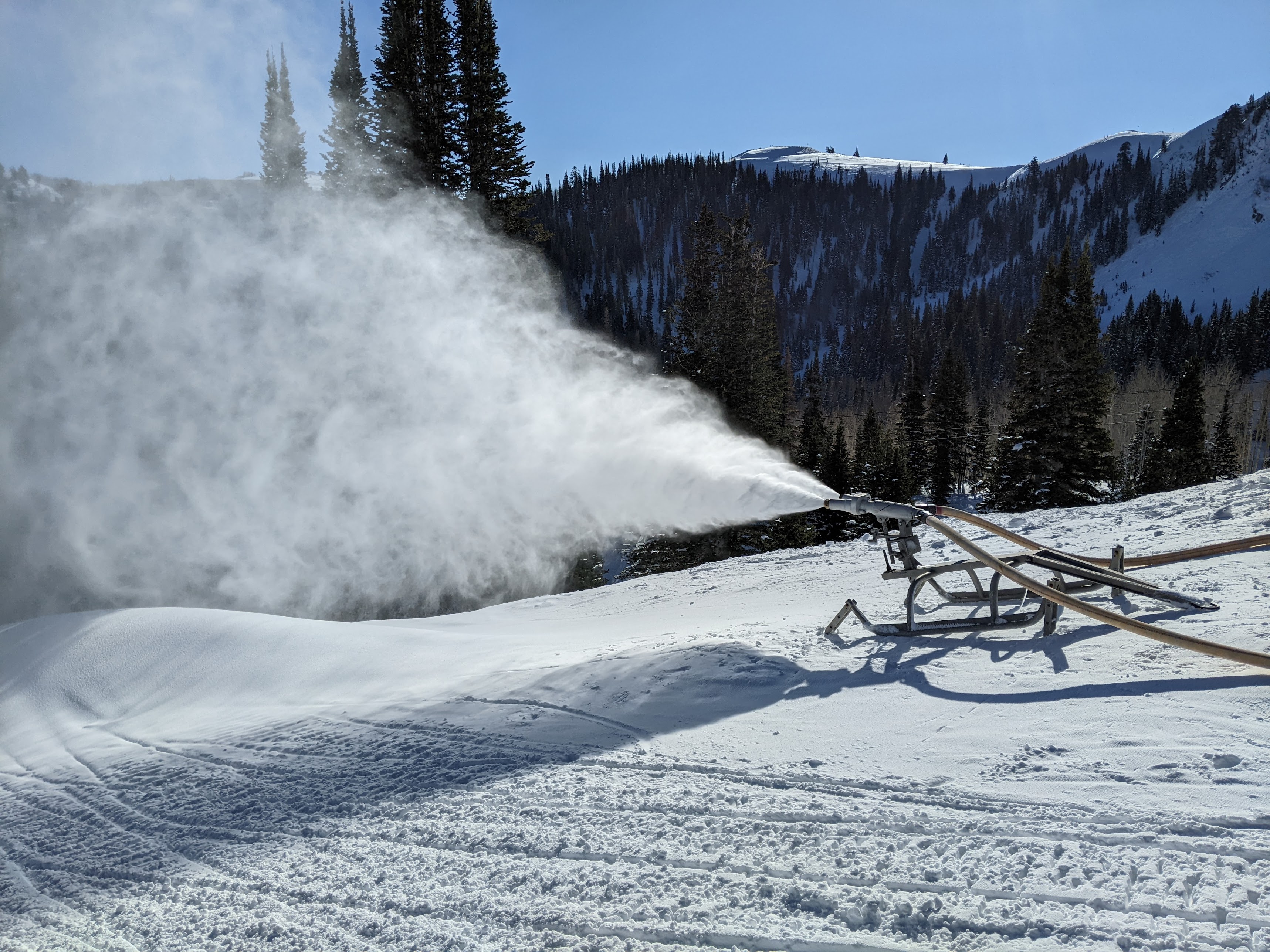
"Storm 1" for this cycle is in the books.  Per the Utah Avalanche Center report this morning, snowfall totals were 15–35" with 1.58 to 2.95" of snow water equivalent.  Backcountry tree skiing yesterday was simply superb on all aspects.  It's great to have a right-side-up storm on a deep base with a low-angle sun in late December.  

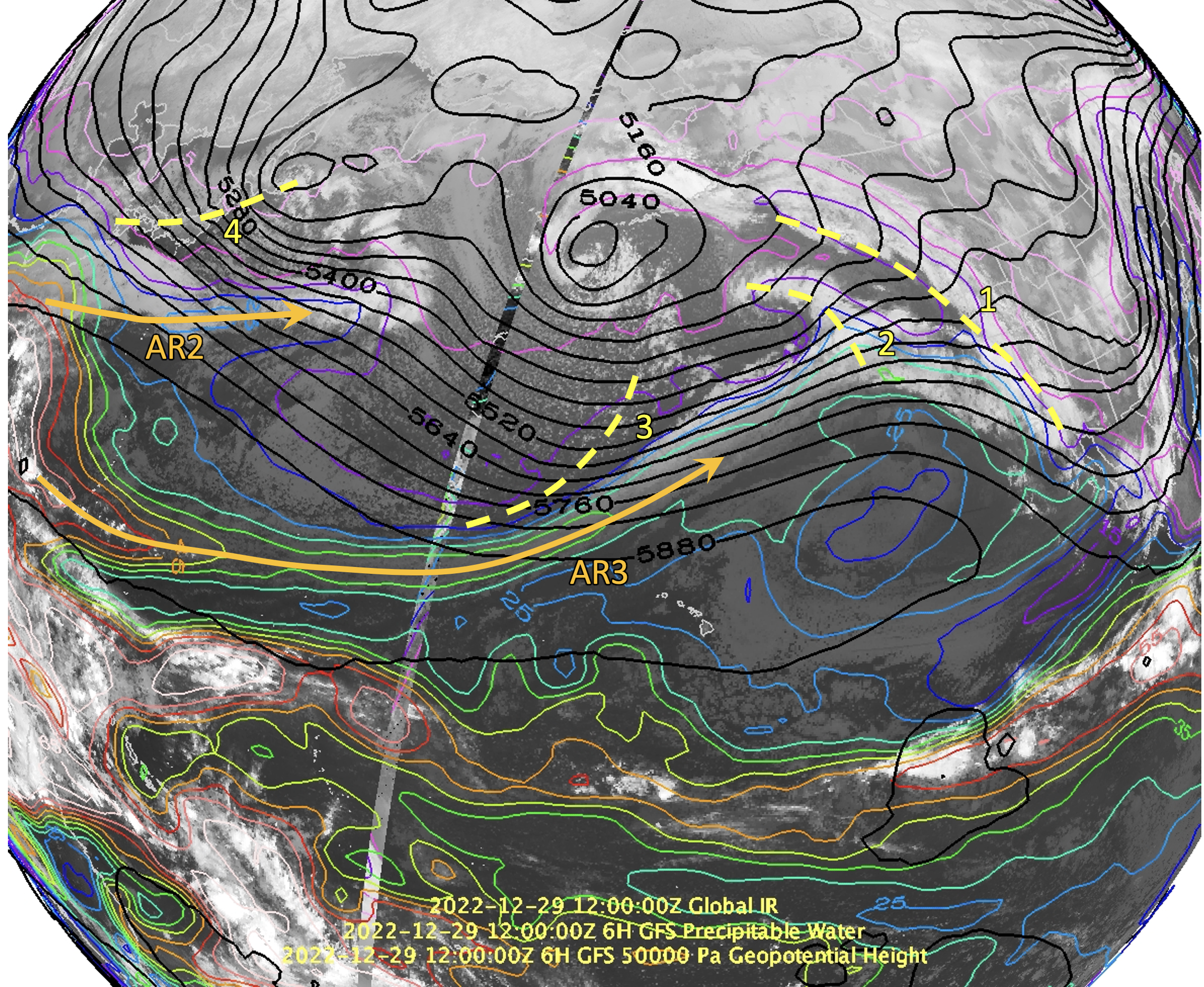
The well-advertised parade of storms is set to continue over the next few days ad the Pacific Basin is ready to get it on.  As of 1200 UTC this morning (5 AM Thursday December 29) there were four key storm systems and two major atmospheric rivers upstream over the north Pacific.  Storm systems 1 and 2 were along or just off the Pacific Coast this morning.  These are expected to weaken as they move inland, brining just some periods of mountain snow showers through Friday.  

Storm system 3 is potentially the big one as it is accompanied by a potent atmospheric river that extends upstream into the tropical west Pacific.  The term pineapple express is sometimes used for atmospheric rivers originating near Hawaii.  This one, however, connects back to the Philippines.  

Currently, storm 3 doesn't look like much, and this is where storm 4 comes in.  Storm 4 is currently over the Japanese Archipelago and it too is accompanied by an atmospheric river.  Storm 4 is expected to amplify as it crosses the Pacific.  This in turn will build a ridge immediately upstream of storm 3, which in turn will amplify as it moves into the western United States.  This is a process known as downstream development.   The availability of moisture from the tropics and sub-tropics with these systems amplifies this process.  

So, in the wake of storms 1 and 2, moisture associated with the storm 3 atmospheric river streams across northern California and Nevada to northern Utah on Friday night, as illustrated by the GFS forecast valid 0600 UTC 31 December (11 PM MST Friday).  


Then the amplifying storm 3 moves onshore Saturday, with continued precipitation over northern California, Nevada, and Utah.  The heartburn aspect of this forecast is the possibility for the precipitation band to shift northward.  


We remain in the moist southwesterly flow ahead of the system for an extended period Saturday night and into Sunday.  


Finally the system moves downstream and we get into the wrap around/northwesterly flow Sunday night and into Monday.  


Got all that?  Yeah, it's hard to summarize, and this is just the GFS.  There are variations depending on the modeling system or ensemble member.  The ECMWF HRES, for example, is less amplified, although that puts northern Utah in a robust warm-front on Saturday afternoon, with heavy precipitation.  


So, let me summarize and speculate.  Remnants of storms 1 and 2 will move through friday, but won't do much.  Maybe a few mountain snow showers.  Things begin to pick up late Friday as the atmospheric river preceding storm 3 steams inland and reaches Utah. At that point, many models, like the GFS, really start to crank it up, as evident in the GFS-derived Little Cottonwood forecast below.  


The GFS water equivalent through 11 AM Monday is over 3.5 inches.  The ECMWF HRES has 2.5" for Salt Lake City and values in excess of 4" in the "HRES Mountains" from Alta south (these models don't properly resolve the terrain so you get oddities like this without downscaling). 

Source: Pivotal Weather

Our downscaled NAEFS product for Alta-Collins has water totals of 4 to 11 inches through 18Z 2 January, which corresponds to 11 AM Monday.  


Bottom line is this looks like another big water cycle for the Wasatch provided the storm doesn't amplify too much, putting us in the warm sector and reducing the cross-barrier flow component.  I haven't talked about snow levels, but they are strongly dependent on the amplification as well and will vary a lot during the period, but they will probably rise on Friday and could be in the 6000 to 7500 foot range Friday night through Sunday when they may decrease again.  Check forecasts for updates as this could change.  

Note that I didn't include the NAEFS snowfall plumes for Alta.  I've thrown those out as they just seemed unrealistically high. 

Tuesday, December 27, 2022

Pacific Storm Track Makes Holiday Visit

The next week looks very active as the Pacific storm track has finally got its act together and is going to bring a parade of storms to northern Utah and much of the western U.S. 

Below is the GFS 500-mb analysis for 0600 UTC 27 December (11 PM MST Monday) showing strong westerly flow extending across nearly the entire Pacific basin.

Coincident with the strong jet is potent atmospheric river that also extends across nearly the entire Pacific.  

The downscaled NAEFS plume for Alta-Collins is known for overforecasting, but is laying down some big numbers with 6–13" of water equivalent and 100+ inches of snow over the next seven days.  


Those numbers are eye popping, but I often use the plume for Brighton as a better approximation and even it is in the 5–10" range for SWE and 60–120" for snow.  


Let's take a closer look at the event for today and tonight, beginning with the situation as I prepare this post on Tuesday morning.  At 7:40 AM MST, it was quite mild across the region with temperatures in the high 40s and low 50s in the Salt Lake Valley, including some readings in the high 50s along the east bench.  Even in the mountains, temperatures were in the 40s at many stations.  Even on Mt. Baldy and Hidden Peak it was 34˚F!


The GFS forecast for 1800 UTC 27 December (11 AM MST Tuesday ) shows strong southwesterly flow at nearly all elevations with a broad atmospheric river extending across California and the Great Basin to Utah.  


Given all of that tropical moisture, it is going to be very warm today, with 700-mb temperatures as high as +2˚C in western Utah.  Beneath a band of precipitation that will be moving in this morning, however, it is a bit cooler (-2 to 0˚C) due to cooling from evaporation and melting.  


Nevertheless, the GFS wet-bulb zero level reaches as high as 9600 ft at 10 AM at Alta.  


I would not be surprised for there to be rain this morning or in the early afternoon to altitudes as high as 8500 feet and wet flakes falling at even higher elevations.  Later in the afternoon, the snow level will decline to closer to 7000 feet before dropping further overnight.  

For Alta-Collins, at 9600 ft elevation, the GFS is putting out 1.55" of water and 15" of snow through 9 AM Wednesday.  Water contents are forecast to be 20% to start today, but declining to 5% tomorrow, so this will be a right-side up storm.

The reason for the lowering snow level and right-side up snowfall is the passage of a cold front overnight with the flow shifting to northwesterly, as can be seen in the time-height section below.  


In terms of water totals, the 12Z HRRR is even wetter, putting out 2.42" for Alta and even bigger numbers in areas that are typically "favored" in the moist southwest flow we will see ahead of the front including 4.32" at Sundance and 3.03" at Ben Lomond Peak by 1600 UTC (9 AM MST) tomorrow.  Unfortunately some of that precipitation will fall as rain today at those locations.  

The bottom line is expect mild, windy weather with occasional rain, heavy at times, at mid elevations and wet, high-density snow at upper elevations today.  Conditions improve later today and tonight as temperatures decline and snow levels drop.  

Buckle up.  This is just the first of many.

Sunday, December 25, 2022

Holiday Wishes

Thanks for visiting the blog again this year.  Here are a few holiday wishes from the Wasatch Weather Weenies.

For Utah Nordic skiers: A season that runs continuously into April.

For the Alta Ski Patrol: No more riming of the Mt. Baldy anemometer.

For the UDOT Avalanche Team: No surprise high intensity nighttime snowfall events.

For Alta beginning skiers: A functional Sunnyside chair.

For other Alta skiers: Many country club days.

For Snowbird skiers: A new tram (isn't that enough?).

For Brighton skiers: Steeper terrain.

For Solitude skiers: Limits on the number of IKON days.

For Cottonwood Canyons skiers: A real transportation plan.

For Deer Valley skiers: A foot of freshly groomed snow every day.

For PCMR skiers: Fully open and staffed mountain operations.

For Snowbasin skiers: Fewer IKON skiers.

For PowMow skiers: A cessation of all talk about Powder Mountain.

For Sundance skiers: More snow in northwesterly flow.

For backcountry skiers: Further strengthening of the persistent weak layer.

For the Utah Avalanche Center: No more persistent weak layers.  Ever.

For the National Weather Service: Accurate, low spread ensemble forecasts.

For Evan Thayer @ OpenSnow: Continued success of the whale (we all win with this).

For all readers of this blog: Many safe and deep powder days.

Happy holidays!

Jim

Thursday, December 22, 2022

The West–Northwest Wind Doth Blow

It snowed last night, but the real story was the wind.  Paraphrasing Mother Goose,

The west-northwest wind doth blow,
And we shall have snow,
And what will poor skiers do then?
Poor things!
They'll sit in a car,
And to keep themselves warm,
Will hide their heads under their wings,
Poor things!

OK, that doesn't quite work, but the west-northwest wind did blow hard last night.   I'll focus here on Mt. Baldy because it has reported quasicontinuously to MesoWest for some time.  I just happen to have a plot of the observed wind gusts on Mt. Baldy over the past three cool seasons (1 October - 8 May).  Events with gusts in excess of 40 m/s (80 knots or 89 mph) have happened about once or twice a cool season over the past 3 seasons. The peak gust over the past 3 cool seasons was 47.7 m/s (93 knots or 106.8 mph), which occurred at 2 AM MST 14 January 2021.   

Observations from that event show it also featured west-northwest flow and saw gusts at or above 99 mph for four hours.    


Last night the peak gusts weren't quite as high, but there were six consecutive hours with gusts at or above 90 mph, compared to 4 in the 2021 event (apologies for the different y-axis scale, but MesoWest is being cranky this morning). 


So, a pretty good blow that didn't quite hit the highest in the past 3 seasons but had a relatively long duration.  Hidden Peak hit 130 last night, which seems crazy high, but MesoWest hasn't been receiving their data as frequently the past few years and I don't know if all of the work on the tram and summit may have resulted in changes that could affect their readings.  The reality is that wind measurements are extremely sensitive to instrument, exposure, and the shape of the topography and buildings. 

The wind is a bummer, but no complaining.  Have you seen the wind chills on the other side of the divide?  True suffering over there.   

Tuesday, December 20, 2022

We Will Likely Be Kissed by Arctic Air

As mentioned in prior posts, a major surge of cold air will affect a significant portion of the continental United States over the next several days.  

To be sure, an impressive pool of cold air lies over Alberta this morning with many stations at or below -30˚F and a few in the -40s.  Cold air is pushing into the northern Plains already with temperatures in North Dakota already as low as -29˚F.  At least it's windy too!

The large-scale setup for this cold surge involves interactions between high-latitude and midlatitude circulation features.  Last night, at 0600 UTC 29 Dec (11 PM MST Monday), an upper-level ridge was parked just north of eastern Siberia in the high latitudes with a weaker ridge in the midlatitudes over the northeast Pacific. 

Over the next two days, the upper-level ridge north of eastern Siberia strengthens further into an upper-level anticyclone while the midlatitude ridge migrates eastward.  Concurrently, an upper-level trough drifts across central Asia with the closed low to the north impinges on the ridge north of eastern Siberia.  This results in a remarkable upper-level flow pattern in which there is quasi-continuous ribbon of upper-level flow from central Asia across the high latitudes, and down into the central United States (red line).  


Little wonder that this will be a potent cold surge.  

Current forecasts suggest, however, that the Salt Lake Valley will only be kissed by the cold surge.  Below is the forecast for 1200 UTC 22 December (5 AM MST Thursday) when the coldest air should be over northern Utah.  While temperatures across much of central and eastern Wyoming are generally near or below -20˚F, and even the Snake River Plain has temps in the single digits (even colder in the upper Snake River Plain) they are much higher in our part of the world.  This is due to the blocking of the coldest air by the terrain to our west and north, but also the fact that what air does make it into the Great Salt Lake Basin experiences some downslope warming.  

Source: tropicaltidbits.com

Still, it is likely to feel quite cold in the Salt Lake Valley on Thursday with highs in the 20s and a stiff north wind.  If you want to be colder, try Logan or Evanston.  

There is still some uncertainty in those numbers.  The coldest forecast models have highs in Salt Lake City in the mid teens, whereas the warmest are in the low 30s.  The bulk lie between the high teens and the high 20s.  

For the mountains, there is also some notable weather.  What caught my eye are the strong winds Wednesday night as the arctic air approaches.  Our GFS-derived forecast for Little Cottonwood shows peak wind gusts on Mt. Baldy of 80 mph.  Earlier runs had gusts as high as 95.  


The reason for this is the strong northwesterly jet aloft and above the edge of the arctic air.  GFS forecast 700-mb winds are at or above 45 knots in northern Utah with the upper-level jet parked right over northern Utah.  Buckle up if you are flying into our out of KSLC during this period!

The models are also calling for a hit of snowfall in the mountains Wednesday and Wednesday night, which would be greatly appreciated, assuming it doesn't end up in Evanston.  

A curious aspect about the current forecasts is that the arctic air bleeds into Utah in a way that temperatures at upper-elevations are not that much colder than they are on the valley floor.  The GFS forecast sounding for Salt Lake City, for example, shows surface temperatures around -5˚C (23˚F), but at 700 mb (10,000 ft), the are -10˚C (14˚F).  

However, with very cold air lurking though just to the north and east, I would be cautious about counting on that forecast at this time.  It could verify, but depending on how strong the cold surge is and the depth of the cold air, there are a wide range of possibilities.  It might be warmer, for example, at upper-elevations than in the Salt Lake Valley if the cold air bleeds in from the north in a shallow layer.  On the other hand, it could be much colder than indicated above if the cold surge comes in deep.  This is a time I would pay very close attention to the observations and the forecasts before packing my pack for touring.  

Monday, December 19, 2022

What Is Artificial Snow

Depending on how you look at it, artificial snow is either a blessing or a necessary evil.  Even in Utah, it has become essential to start the ski season in most years and ensure coverage in heavy traffic areas during the season.  Natural snow is far superior for skiing, but even I've learned to live with the reality that we are lucky to have snow from hoses.

Snowmaking at Deer Valley

Utah likes to say that it has the Greatest Snow on Earth, but it also has some of the Greatest Snowmaking Weather on Earth.  For snowmaking, it's not the temperature that matters, but the wet-bulb temperature.  The wet-bulb temperature is the minimum temperature that air can be cooled through evaporation.  It depends strongly on the humidity.  When the humidity is low, the wet-bulb temperature can be several degrees or more lower than the actual temperature, sometimes enabling snowmaking when the temperature is actually above "freezing." On the other hand, when the humidity is high, snowmaking can be difficult when temperatures are just below freezing.  

Thus, Utah's arid climate means we often have low humidity, and that helps with the snowmaking.  When I took the photo above, Deer Valley was pumping out the artificial snow like there was no tomorrow and the wet-bulb temperature was about 15˚F.  

I often say that artificial snow isn't really snow at all.  It is comprised ice crystals, but one difference from natural snow is that the ice crystals don't experience growth through what is known as deposition.  Deposition is the direct conversion of water vapor into ice.  It is the process through which those beautiful six-armed snowflakes and many other ice crystals form. 

Real snow can also grow through a process known as accretion, which is the gradual accumulation of mass as supercooled cloud droplets freeze on contact with larger ice crystals.  At the extreme, this leads to graupel.  

Cloud droplets are, however, extremely small.  A typical cloud droplet is 20 microns in diameter.  This is smaller than the diameter of a human hair, which is about 70 microns.  Thus, cloud droplets are incredibly small and it takes enormous quantities of them to produce a graupel particle.

In contrast, artificial snow is comprised of frozen water droplets.  These droplets are relatively large with diameters of 0.5 and 2 mm.  That's 25 to 100 times bigger than a cloud droplet.  Sometimes they stick together forming an aggregate of frozen droplets.  Below is an example of the aggregates of artificial snow droplets that fell on my sleeve when I skied beneath the snowgun in the photo above (click to enlarge).  Note that there are no plates or tree-like arms.  Just lots of frozen droplets.  

As a result, artificial snow is very dense, typically with a water content of 22–28%.  For comparison, freshly fallen snow at Alta is 8.4% and at the Central Sierra Snow Lab at Donner Pass in the Sierra Nevada it is about 12%.  So artificial snow is much denser than most forms of freshly fallen natural snow.  This is true even if the artificial snow is relatively "dry" with very little liquid water.  You couldn't make a snowball with the artificial snow above because it was too dry, but I could also barely push my pole into it because the density was so high.  

That density is a blessing and a curse.  It enables artificial snow to be extremely durable.  It isn't skied off easily.  However, it also makes for a much harder skiing surface that can polish up into a skating rink.  

One thing is for sure.  Love it or hate it, artificial snow is here to stay.  If it's critical for skiing in the current climate, its importance will only grow in the coming decades.  However, a group led by Peter Veals, a research professor at the University of Utah, is working to produce artificial powder.  Check it out here: https://www.quantum-snow.com/

Sunday, December 18, 2022

When Almost Anything Can Happen

A few days ago, some of the "deterministic" global forecast models, namely the GFS and the ECMWF HRES, forecast a truly spectacular cold surge for the continental United States this coming week.  There were a few forecast runs that brought the cold surge directly into the mountain west.  Below is an example from the ECMWF HRES initialized on 0000 UTC 13 December, which produced a 240 hour forecast [valid 0000 UTC 23 December (5 PM MST Thursday) with a spectacularly low 700-mb (10,000 ft) temperature of -34˚C (-29˚F) over southern Wyoming and -30˚C over Salt Lake City.  

How insane is cold air like that for Salt Lake City?  A 700-mb temperature of -30˚C has only been observed once in the upper-air sounding record for northern Utah, which began in 1950.  


However, today we run ensembles of forecasts to get a handle on the uncertainty in the forecast, and other members of those ensembles had different ideas.  Some didn't bring the cold surge into northern Utah.  

It is relatively easy to view forecasts from the GFS or ECMWF HRES out to 10 or more days online.  The GFS and ECMWF HRES are higher resolution than the members of their respective ensembles (known as the GEFS and EPS, respectively) and there may be some validity to weighting them a little more heavily in a short range forecast, but there is little validity to doing so in a medium range forecast.  After a few days, the higher resolution GFS or ECMWF HRES aren't significantly more accurate than the lower resolution members of their respective ensembles.  

This is because large scale forecast uncertainty trumps resolution at long lead times.  The development of high and low pressure systems and waves in the jet stream is too uncertain to place great faith in a single high resolution forecast model.  Going all in on the GFS or the ECMWF HRES at day 10 makes little sense.

Now let's forecast to today.  The ECMWF is still forecasting a potent cold surge, but at 0000 UTC 23 December (5 PM Friday), which corresponds to the same time presented above, the coldest air is located farther east and centered over Nebraska and the high plains.  


Northern Utah, however, is in the strong temperature gradient on the southern and western edge of the cold surge, and this is still a very very difficult forecast situation.  If cold air shifts a bit eastward or westward, it will make a HUGE difference in our temperatures.  HUGE.  

The National Weather Service "National Blend of Models" or NBM is a forecast system that pulls in data from the various global ensembles and produces not one but many forecasts based on those members.  This allows one to look at the range of possibilities, or what one might call a distribution.  Below are box-and-whisker plots of the maximum and minimum temperature forecasts for Salt Lake City based on the NBM forecasts from 6 AM this morning.  Prior to the 21st, the boxes are relatively squat.  Then on the 21st they get very tall. This continues through the 23rd, when the get squat again.  


In the box and whisker plots above, the middle half of the forecasts lie within the box.  The fancy word for this is interquartile range.  Whiskers then extend above and below the box and those cover the middle 80% of the forecasts.  Essentially, this is a visualization of how large the range of forecasts is, and that range is very large from the 21st to the 23rd because we are on the edge of the cold surge.

If the cold surge remains to the east or just barely trickles in, the highs on Thursday could be around 40 or even higher since there are a few forecasts that are above even the top whisker.  If the cold surge pushes west and we get deep in the cold air, highs could be a very nasty 15˚F or colder.  Minimum temperatures also show a huge range during this period.  Basically, almost anything could happen (within reasonable limits).

For maximum and minimum temperature, the NBM suggests that the period covering Thursday and Friday is the most difficult to predict of the next 10 days.  Although we think of uncertainty as increasing with increasing lead time, for Salt Lake City, the uncertainty actually goes down again in this instance because of the extreme sensitivity of what will happen with the cold surge later this week.  

We will see where all of this ends up.  Right now there are a lot of possibilities that Mother Nature could roll with her weather dice.  

Thursday, December 15, 2022

STEENBURGH WINTER IS HERE!!!!

What a storm!  At 2 PM 15 December, the snow depth at Alta-Collins reached 100", officially marking the beginning of Steenburgh winter.  The 33" snow interval ob is clearly spurious, but having some sort of observational irregularity to add to the controversy of this announcement always adds to the fun.  

Long-time readers of this blog know the importance of Steenburgh winter, but new readers may not.  I coined the term during a moment of narcissistic weakness during the winter of 2010/11, an epic year in which Alta-Collins reached 100" on December 20th (see Last Day of Steenburgh Winter from February 10, 2011).

As I wrote then, there are many ways to define winter.  There is astronomical winter, which runs from the winter solstice to the spring equinox.  There is meteorological winter, which is typically defined to run from the beginning of December to the end of February, and then there is Steenburgh winter, which covers the prime powder skiing season in the Wasatch when there is a deep snowpack and a low-angle sun so that the powder lingers for extended periods in the backcountry.

I have high standards.  That is why this blog's motto is "Mountain Meteorology and Snow Snobbery."  If you want to see someone excited about dust-on-crust, you've come to the wrong place.  

Steenburgh winter is about the crème-de-la-crème of Wasatch backcountry skiing.  It is the period from the date we reach a 100" base at Alta-Collins to February 10th.  Why 100"?  Because that's about when much of the Wasatch Backcountry opens up, including rocky areas in the Lone Peak Wilderness.  Why February 10th?  Because that's when the combination of sun angle and day length get large enough that even short appearances by the sun can have a caustic influence on the south side of the compass and have a growing influence on the northern side as we move deeper into the spring.  

If we don't get to 100" by February 10th, there is no Steenburgh winter.  Indeed, in recent years, Steenburgh winters have been rare.  This year, I think we will have the longest Steenburgh Winter since I started this blog and possibly since the 21st century began.  If my sleuthing of the records is accurate, previous early Steenburgh winters occurred in 2004/2005 (100" on December 30th) and 2010/11 (100" on 20 December).  

Thus, this season will provide the longest Steenburgh winter in at least 22 years.  Who knows, maybe it will ultimately be the longest Steenburgh winter of the 21st century?

Controversy

Steenburgh winter is not without controversy and it remains contentious today.  Let me address many of the criticisms one by one.

1. The snowpack can settle back below 100 inches: Yes it can.  I confess I didn't really think about this when I coined the phrase.  It is common for narcissists to do things impulsively.  I recognize this is a problem, but precedent has been set.

2. Total snow depth is not the best measure of how fat the snowpack is.  For sure and indeed I think snowpack water equivalent would be a better variable to use as it is a better measure of how fat the snowpack is and it is less likely to decline significantly, unlike snow depth.  For example, in 2004/2005, we didn't reach 100" until 30 December, but on this date there was more snowpack water equivalent at the Snowbird SNOTEL than there is today.  Based on prior Steenburgh winter records, we could use 16" of snow water equivalent, but that is such a BORING number.  A 100" snow depth is a major psych point and even in metric, 2.5 meters sounds pretty good.

3. There can be good skiing before a 100" base and after February 10th.  Yes yes.  I know this.  I have skied great powder while bottom-feeding in October and on Memorial Day weekend when we are almost dealing with a summer solstice sun.  The point here is to isolate the period with both a fat snowpack AND a low angle sun for powder preservation.  Yes, I know that high north aspects can preserve snow pretty good later than February 10th, but I tell you there is something obvious that happens around February 10th.  Skin up Flagstaff from Alta on a sunny powder day in mid January and compare with mid February.  I tell you, you can FEEL the difference, and on the following day in February you will feel the sun crust.

Enter your complaints below so I can address them one-by-one, but don't expect me to yield.  And be sure to get out and enjoy the almost 2-month Steenburgh winter this season!

Wednesday, December 14, 2022

Calling a Wrap on the Great Dendritic Storm Cycle of December 11–14, 2022

What an incredible, long-duration, dendrite-filled storm.  I'm calling it a wrap, although the next storm moves in tonight.  

I'm pretty certain Alta came in at over 50 inches. The NWS had them for 47 inches at 430 AM this morning.  They got another 6 inches of cold smoke today.  53 inches here, 53 inches there, pretty soon it adds up to great skiing.  

Indeed we did some deep-dive dendritic sampling in the Wasatch Backcountry today.  The ages of my partners ranged from 24 to 65, the former for trail breaking and the latter to show old-school powder skiing form.  I started the day with a proper breakfast for an all-day tour.  

Snowfall during the day was light, but consisted of primarily of lightly rimed ice crystals, many of dendritic, six-armed form that has dominated the storm cycle. 

There was only a very brief appearance made by the sun and it provided only feeble warmth.  


We are not quite to the coveted 100 inch base at Alta Collins for official Steenburgh Winter to begin (peak so far is 95"), but do you know how lucky we are to have this much snow with the low angle sun of December?  Granted the avalanche conditions are an issue, but all aspects harbor the Greatest Snow on Earth right now.  It's all good.  How about those south aspects today...


The best powder skiing we had today was on the south side of the compass.  I love the low angle sun!

Tuesday, December 13, 2022

Cold Smoke

What an incredible night of low-density snow at Alta.  From the 4 PM board wipe yesterday afternoon to 7 AM this morning they've had 10 inches of snow with .31" of water for an average water content of 3.1%.  There is a tendency for precipitation gauges to undercollect snowfall, but still, this is very much cold smoke. 

Let's take a look at why the snow is so low density.  Two important clues are in the morning upper-air sounding from the Salt Lake City International Airport.  First, the temperatures between about 750 mb (2500 m/8000 ft) and 650 mb (3500 m/11,500 ft) are between -12 and -18˚C.  This is in the heart of the temperature range for growing dendrites, those six-armed snowflakes that we all love and can create low-density snow.  I've identified this region with the green box. 


The second is that the winds in this and the surrounding layers are very light: 15 knots or less.  Thus, Mother Nature isn't bashing these flakes and they are less damaged when and after they reach the ground.  Ridge top winds have picked up some this morning, with ridge-top gusts reaching 30 mph, so there could be some localized wind transport going on, but for the most part, this is fantastically dry snow.  

We can also have a look at the profiling radar system we are operating at Alta this winter.  This radar provides vertical profiles through the storm, so we can create time-height sections like the one below, which are a high-resolution profiles focused on the lowest 900 meters or so above Alta (up to about 3600 m/11,800 ft).  Radar reflectivity in the top panel indicates that echo tops were very shallow, sometimes reaching only 700 m above the instrument.  At other times the max out just beyond the high-resolution range (lower resolution data shows spikes to just over 1000 meters).  Basically, this is a very shallow storm and most of it is in the dendritic growth zone.  

Notice also that the radar reflectivity generally increases toward the ground.  This is consistent with the growth of snowflakes as they are falling, maximizing near the surface.  This is all happening in an incredibly shallow layer.

The middle plot presents the Doppler velocity, which in this case represents the air motion plus the fall speed of the snowflakes.  These velocities are generally weak, and fluctuate from weakly positive to weakly negative, with a bias toward weak negative vertical velocities.  This is consistent with shallow, weak convection in which there are fluctuations from weak ascent to weak descent.  The slight negative bias is a result of the fall speed of the dendrites, which is around 0.5 to 1 meter per second and always toward the ground.  Basically, the storm is like a shallow pot of water on simmer.  

We also have an instrument at Alta that measures the size and vertical velocity of falling particles.  This allows us to get some idea of the composition of the precipitation.  In the plot below, we present a summary of the observations over a 1-hour period ending at 0900 UTC (2 AM MST).  The fall speed of particles varies depending on the composition and size, so we have added lines of what we might expect from pure rain, graupel, and dendrites.  Many of the particles during this period lie near or along the dendrite line, which is what we would expect and consistent with the cold smoke (the spike on the left side of the graph to the lower part of the rain line is an artifact that we haven't quite teased out yet).

There are some variations in what this instrument saw overnight, so if you were to take a close look at the snow crystals, perhaps you would see some very small graupel particles or other ice crystals at times.  Storms are almost always a stew of particles.  

Enjoy the skiing if you are up today.