Showing posts with label Snirt. Show all posts

Tuesday, May 27, 2025

Death of a Snowpack

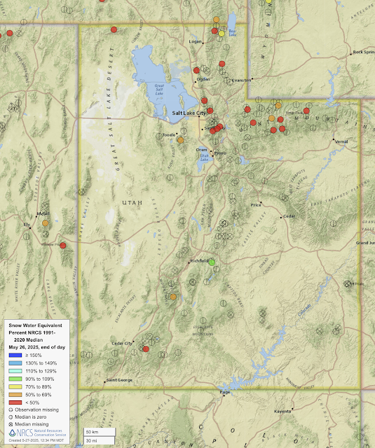
A look at the latest snowpack water equivalent numbers from Utah SNOTEL stations shows that most are now snow free.
Source: NRCS

Don't be fooled by the red dot in southwest Utah.  That's the Midway Valley SNOTEL and it hit zero on May 15.  The red fill is spurious.  There are only two other sites in Utah with measurable snow, Big Flat (orange) at 10,320 ft in the Tushar Mountains, and Farnsworth Lake (green) at 9,620 ft in the mountains east of Richfield.  

The northern Utah snowpack is also non-existent at most SNOTELs [and some of the red dots above are also spurious and there's no snow at the site (e.g., Ben Lomond Peak, Lookout Peak, Brighton)].  Those with measurable snow are at high elevations and only one, USU Doc Daniel (yes, that's the name) is over 70% of median (and it's at 71%).  

I actually don't like using the percentage of median this time of year.  Instead, I look to look at how many days ahead of median the melt out is. If we look at Snowbird, for example, we see that the current snowpack water equivalent (black line) is 12.1 inches.  The median snowpack (green line) reaches that on June 3rd, so the melt out at this site is about a week ahead of median. 

Source: NRCS

The Snowbird site seemed to have a lot of problems earlier this winter, so perhaps there's a bit more uncertainty in that estimate, but a quick eyeball suggests meltout about 3-10 days ahead of median at many northern Utah sites.  

For the snow that remains, it's a bloodbath with near ideal conditions for melt in Utah through the weekend with a high-amplitude ridge in place, above average temperatures, long days, and a high-angle sun.  Most of the energy to melt snow in northern Utah comes from the sun and there's going to be a lot of incoming solar radiation the next several days.  

In some areas, the snow surface has also been darkened by dust.  The Alta High Rustler web cam shows a snowpack that is quite "snirty". 


A dusty snowpack absorbs more solar energy than a white one, so snowmelt at places like Alta is accelerated.  

In the past 5 days, the snow depth at Alta Collins decreased from 92 to 76 inches, an average of 3.2 inches per day.  At that rate, we'll be down to about 60 inches by June 1.  My guess is we'll be a bit lower than that given the pattern.  

Saturday, May 20, 2017

Still Skiing

I've had an unused day of skiing at AltaBird thanks to my Mountain Collective Pass and decided I'd use it today.  With a fresh coat of the white stuff, the mountains were quite stunning this morning.


Conditions were quite good for May 20th.  Carveable up high, some refrozen spring snow down low.  Stuff softening up depending on aspect as the day went along.


Given that I hadn't ridden lifts in a month, we racked up vertical on the groomers and called it good at noon.  I like the 8 am open.  That's really nice this time of year for early risers like myself.

Unfortunately, the snow under the fresh coat looks pretty dirty.  In a couple of days, we'll be skiing snirt instead of snow.

Friday, April 22, 2016

Thursday, April 21, 2016

Is Our Nearly Snirt Free Spring Coming to an End?

As far as dust storms go, this past cool season has been pretty quiet.  We've had a few minor events, but nothing significant, and the Wasatch snow cover remains fairly white and relatively snirt free (snirt = part snow part dirt, the dirt meaning dust).

The lack of dust so late into the spring is fairly unusual.  Estimates of total dust flux at the Salt Lake City international airport show a pronounced peak in April.
Source: Steenburgh et al. (2012)
What's been missing this year are strong south wind events that can tap into dust emission sources in southwest Utah.  We simply haven't had them, but that's about to change.

With the approach of an upper-level trough, we will see the development of south winds tomorrow.  The 1200 UTC NAM forecast valid at 0000 UTC 23 April (6 PM MDT Friday Afternoon) shows the upper-level trough over northern California with 30–40 knot SSW 700 mb (10,000 ft) winds and 15–25 knot SSW surface winds over western Utah.


The situation is not quite ideal for a strong wind-driven dust event as the surface trough is not especially deep and the surface front is still over eastern Nevada (ideally we want the front moving into northern Utah late in the afternoon), but it is the first event we've had this spring with the potential to stir things up.  We'll have to see tomorrow if the winds are strong enough and if the land-surface is ready for dust emissions.  I prefer my corn white, so I'm hoping that's not the case.

Oh, and in case you are wondering, some cream on crust is looking likely for the mountains on Saturday.

Sunday, April 19, 2015

Closing Day (#1)

It was the first closing day of the season at Alta today.  Although the freshies are gone, the turns were quite good and you could carve a hell of a trench for much of the afternoon.

As usual, costumes and revelry prevailed for the day.


Special thanks to this dude for throwing in some old-school air and for keeping his clothes on.


Snirty snow is already making an appearance in wind scoured and sun exposed areas.  A brown spring is in our future.


There was something in the air throughout the day obscuring the views.  I was wondering if it was smoke from the Siberian fires.  Perhaps one of you out there can take a look and comment.


Now is a good time to say thanks to all the avy pros, patrollers, snowmakers, groomers, and lifties for their exceptional efforts this difficult snow year.

Friday, April 17, 2015

Dusty Snow: The Monster in the Basement

"A very strong cold front arrived on April 15th with near hurricane velocity winds.  The storm knocked down trees, signs and power poles all over Utah and filled the air with choking dust.  In the next week, 42 inches of snow fell on top of the chocolate brown layer of dust.  Backcountry recreationists had their last fling with some of the best powder of the season on mostly stable snow.  Then, finally, spring arrived."
Sound familiar?  That quote is from the Utah Avalanche Center 2001-2002 annual report.  The very strong cold front on April 15th was produced by the 2002 Tax Day Storm, which like the storm we experienced earlier this week, was a huge dust producer.

AVHRR satellite imagery at 2046 UTC 15 April 2002.  Dusty areas not obscured by clouds identified with warm colors in inset at upper left.  Source: West and Steenburgh (2010).
The snow that year was remarkably brown once we were well into the melt season.  We are guaranteed a repeat of that this year, at least in those areas where a snowpack remained prior to this week's storm.

One of our readers, Scot Chipman, sent me the photo below of the snowpack at Snowbird (Volkl thanks Scot for his careful product placement!).  26 inches of beautiful white snow on top of a layer of dust deposited on the snowpack by wind and falling snow during Tuesday afternoon and evening.


As that white snow melts, it will percolate through the snowpack and eventually the dusty layer (a.k.a. snirt - part snow part dirt) will be sitting on top.  Here's how things looked in May last season.


Yes, that was snirty, but this year will be far worse.  I wonder how tolerable late-season tours are going to be once the snirty monster in the basement is sitting on top.

A few people have asked me if all this dust is due to the drought.  Drought may be an exacerbating factor, but the primary factor in dust storms in Utah is strong flow over a disturbed land surface.  Cryptobiotic crusts (pictured below), desert pavement, and other natural surfaces in the desert west are very resistant to erosion.  However, as can be seen by the trails below, they are also easily disturbed.

Source: Secrets of the Greatest Snow on Earth
Thus, we have had significant dust deposition even in relatively snowy/wet seasons.  The photo below was taken at Snowbird in June 2011, at the end of a remarkably snowy/wet season.  Plenty of dust.


Further, the processes influencing dust emissions from playas (i.e., dry lake beds) are very complex and not as straightforward as the surface being wet or dry (see Reynolds et al. 2007 for an example).

The good news is that the snirt is temporarily buried under the new snow in most areas.  Instead of ski it if it's white, try ski it while it's white.

Saturday, April 11, 2015

Hard Core Corn


There have been better snow years in the Wasatch, but the spring skiing right now is surprisingly good.  Mostly hard cores are skiing at this point, so we'll call the conditions "hard core corn."

Aspect is everything, and that's never been more apparent than this year.  South facing aspects on the north side of Little Cottonwood are completely baked out.


As a meteorologist, you should never leave home without a camera as you never know what you are going to see (fortunately, modern smart phones makes this easier).  Here's a nice example of a contrail shadow.  The sun angle was just right that it looked like the shadow was ahead of the contrail.  Then again, maybe there's an X-files episode in this.


Unfortunately, dust is now on the landscape.  Although buried under the mid week snow, it's starting to look snirty in sunny or high traffic areas.  I was hoping that we would see a predominance of white corn this spring, but unfortunately, that probably won't be the case now.


I realized on the way home that I didn't properly say good riddance to inversion season this year.  We'll be making up for that tonight.


Sunday, June 8, 2014

The Last Run

Final turns of the 2013-14 ski season
With a trough dropping temperatures just a bit and the hopes of getting one last day of continuous skiing to the car, my son and I hit Alta today for what I'm sure will be our last turns of the year.

As suggested by the photo below, we probably could have pieced together a continuous non-stop run to very near the base on the Collins side.


However, Alta was asking people not to park on the Collins lot.  It was Sunday, and we figured it couldn't hurt if we did, but being good neighbors we elected to go from Albion instead.

That was painful.  It's remarkable how much snow has melted in the past seven days.  My son was here on Monday and said skiing to the car wouldn't have been a problem.  Today, one had to skip from snow patch to snow patch in the lowest couple hundred vert.


Conditions improved above 9000 feet.  Things looked pretty grim up in the Supreme area (except perhaps Catharines), so we went up to Sugarloaf Pass.  It was a gorgeous day to be on skis and, with temperatures in the 40s, pretty comfortable.


It was really cool to start skiing in a winterscape, but look down at a summery scene in Albion Basin.


Conditions featured everything from bone rattling suncups (near the top, see above photo) to decent corn to snirty sandpaper.  We squeezed out what we could.


That's it for me.  I'm done until the powder starts to fly in the fall.

Friday, May 23, 2014

Snirty Dancing


My son was off school today so we decided to beat the weekend rush for first turns in the Wasatch (ha ha) and go for an early morning tour.  Thanks to this winter's dust storms and Alta preparing to improve the trails in the Corkscrew/Nina's Curve area, the base was rather unappetizing.  

Things looked only marginally better a bit further up the mountain as the impacts from this spring's dust storms are readily apparent and the snowcover is quite dirty.  What a shame. 


 The view of a a few lingering patches of "white corn" mixed in with snirt.


Despite the unappealing color, the snow is well consolidated and skied reasonably well.


The forecast hasn't changed much from my Wednesday update, except that the "pesky trough" is perhaps lingering over the state a bit longer.  Looks like some showers and thunderstorms statewide tomorrow, southern and eastern Utah on Sunday, and perhaps some lingering stuff on Monday.  Afternoon will be the most active period.  Give the hit or miss nature of these storms, keep an eye to the sky and practice common sense lightning and weather safety.

Friday, May 16, 2014

Last Weekend of White Corn?

The head Wasatch Weather Weenie on a rare ski tour
It was a magical day today.

First, I got my favorite e-mail from Google.  You know, the one with the header that says: "You have no events scheduled for today."  Oh, how I love it when that happens.

Then, my back felt unusually spry once again.  I'm hoping this is a trend, but if not, I decided to go for a short ski tour just in case.  If there was 18" new, the day would have been perfect, but 2 out of 3 ain't bad.

As is often the case with spring skiing, timing is everything and we had one great run and one terrible run.  On the ascent, we were quite pleased to find the snirt to be buried and the snow white.  Any hint of yellowing in the photo below is purely an artifact of my poor photography.  The snow had frozen just enough overnight to be supportive.


Our timing was perfect for a great run on a south-facing aspect into Snake Creek where we found the turns to be surprisingly good.  Buoyed for more, we climbed back up to ski out to the car and found nothing but mank and sticky snow on the north aspect where the snow from last week had yet to corn up.  C'est la vie.  One good run given my balky back is still quite satisfying.

This weekend might provide the last opportunity to ski "white corn" this year, if you can find anything that's corned up given the warm nights.  Snirt is already starting to appear in areas where the snowfall last week was light, scoured by the wind, or is melting fast.  It won't be long and the Wasatch will be looking brown and dingy.

This southeast facing aspect holds mostly white corn, but snirt is beginning to emerge
If you do get out, be careful.  We kicked off some really large roller balls and wet sloughs on steeper terrain once things had warmed up.