
A look at the latest snowpack water equivalent numbers from Utah SNOTEL stations shows that most are now snow free.
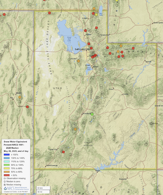 |
| Source: NRCS |
Don't be fooled by the red dot in southwest Utah. That's the Midway Valley SNOTEL and it hit zero on May 15. The red fill is spurious. There are only two other sites in Utah with measurable snow, Big Flat (orange) at 10,320 ft in the Tushar Mountains, and Farnsworth Lake (green) at 9,620 ft in the mountains east of Richfield.
The northern Utah snowpack is also non-existent at most SNOTELs [and some of the red dots above are also spurious and there's no snow at the site (e.g., Ben Lomond Peak, Lookout Peak, Brighton)]. Those with measurable snow are at high elevations and only one, USU Doc Daniel (yes, that's the name) is over 70% of median (and it's at 71%).
I actually don't like using the percentage of median this time of year. Instead, I look to look at how many days ahead of median the melt out is. If we look at Snowbird, for example, we see that the current snowpack water equivalent (black line) is 12.1 inches. The median snowpack (green line) reaches that on June 3rd, so the melt out at this site is about a week ahead of median.
 |
| Source: NRCS |
The Snowbird site seemed to have a lot of problems earlier this winter, so perhaps there's a bit more uncertainty in that estimate, but a quick eyeball suggests meltout about 3-10 days ahead of median at many northern Utah sites.
For the snow that remains, it's a bloodbath with near ideal conditions for melt in Utah through the weekend with a high-amplitude ridge in place, above average temperatures, long days, and a high-angle sun. Most of the energy to melt snow in northern Utah comes from the sun and there's going to be a lot of incoming solar radiation the next several days.
In some areas, the snow surface has also been darkened by dust. The Alta High Rustler web cam shows a snowpack that is quite "snirty".

A dusty snowpack absorbs more solar energy than a white one, so snowmelt at places like Alta is accelerated.
In the past 5 days, the snow depth at Alta Collins decreased from 92 to 76 inches, an average of 3.2 inches per day. At that rate, we'll be down to about 60 inches by June 1. My guess is we'll be a bit lower than that given the pattern.
bad news, Bear river already appears have rather low flow for this time of year and Great Salt lake water level is lower than one year ago and already starting to decline :-(
ReplyDeleteI’d be curious on the year to year variability of this. Doesn’t seem to be melting early, but maybe that’s just the new normal vs how it use to be
ReplyDeleteThere is a lot of year to year variability due to variations in peak snowpack depth, spring weather, and dust. More than you want to know at https://agupubs.onlinelibrary.wiley.com/doi/10.1029/2024JF007957.
Delete