Posts

Showing posts from October, 2015

The Great Salt Lake Is Jacked

Image
The Great Salt Lake may be near its all-time record low elevation and area, but lake-surface temperatures right now are running quite high.  Because the Great Salt Lake is so shallow, lake-surface temperatures often reflect recent temperatures at the Salt Lake City airport and so far this month the average temperature at the airport is a whopping 61.2ºF (16.2ºC).  Consistent with this observation, satellite-derived lake-surface temperatures averaged for the past 2 days are generally above 14ºC, except in shallow areas along the coast, and average 15ºC for the lake as a whole. It's very difficult to place these lake-surface temperatures in a long-term context.  The satellite record is fairly short, and most of the long-term observations are from Saltair a single location on the south coast.  Nevertheless, if we look at the lake-surface temperatures from Saltair for 1972–1988, we find that 15ºC is near or above the upper margins of the range for November 1 (data i...

A Splitting Storm, But Early Next Week Things Get Interesting

Image
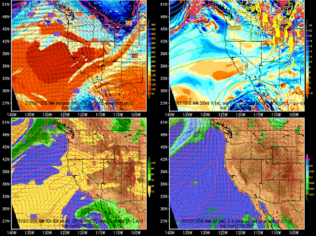
The system moving through the western United States today is a very good example of a splitter.  It was a coherent, full-latitude trough over the eastern Pacific, but stretched and split into two distinct short-wave troughs over the western U.S., one that is moving across the far southwest, the other tracking through the Pacific Northwest and Canada. Although many people feel gypped by splitting storms, the western United States lies climatologically in the exit region of the Pacific jet stream and in an area favoring the stretching and splitting of upper-level systems.  In other words, there's nothing unusual about this happening. As I was heading home on my after-work bike ride yesterday, I noticed it was getting awfully dark. The end of October is here, we switch to standard time on Saturday night, and November arrives on Sunday.  We've had a good run of fall weather, arguably the best in the instrumented record other than October 2004 when it snowed enough to o...

Top 10 Ski Area Microclimates

Image
A microclimate refers to the unique meteorological conditions that occur at a given location or area.  Mountainous regions tend to produce a plethora of microclimates due to the strong influence that complex terrain has on meteorology.  Below are my top-10 U.S. ski-area microclimates, plus some honorable mentions, based on remarkable aspects of the snowfall characteristics compared to the surrounding area or region. 10. Wolf Creek Pass, CO Colorado is not especially snowy, but Wolf Creek Pass is the exception to the rule.  At an altitude of 10,640 feet, the long-term observing site at Wolf Creek Pass has an average annual snowfall of 435 inches, highest in the state.  In addition, Wolf Creek Pass is well situated to be pounded in warm storms with southwesterly flow, resulting in snow with a higher average water content than found elsewhere in Colorado [10.3% ( Judson and Doesken 2000 )]. 9. Gore Mountain, NY Not all microclimates are good for skiing.  Th...

Powder Envy

There are occasionally times when Utahns do have powder envy and that's often the case in the fall when high-altitude Colorado gets the goods while we are still mountain biking. Doug Evans yesterday in the Colorado high country! #winterishere #slashbacksat #SBS #unofficialnetworks pic.twitter.com/ICjCvLgVG2 — UnofficialNetworks (@UnofficialNet) October 24, 2015 Good for them.  Fortunately, we usually get the last laugh.  

The Most Powerful Atlantic and Eastern North Pacific Hurricane on Record

Image
The National Hurricane Center reports this morning that Hurricane Patricia underwent rapid development off the western coast of Mexico last night and is now the most powerful hurricane on record in their area of responsibility, which covers the Atlantic and eastern North Pacific. Source: NHC In their 4 AM forecast discussion, they specifically acknowledge the efforts of the Air Force Hurricane Hunters, noting that "without their data, we would never have known just how strong a tropical cyclone it was."  Data collected by the Hurricane Hunter puts Patricia's sustained winds at 175 knots (201 miles per hour), with a central pressure of 880 mb. The latest forecasts have Patricia making landfall somewhere between Puerto Vallarta and Manzanillo, with hurricane warnings posted for a somewhat wider area.    Source: NHC The potential for catastrophe is high.  The NHC public advisory states "Maximum sustained winds remain near 200 mph (325 km/h) with higher...

The Earth Needs More Cowbell

Image
It's time for our monthly check on global temperatures, which remain at record setting levels.  The National Centers for Environmental Information released the numbers through September and we are running well ahead of previous globally averaged temperatures, as shown in the plot below of January-September temperature anomalies since 1880. An all-time calendar year record has been anticipated now for several months and at this point is virtually assured.

Will This Be a Ski Free October?

Image
Now is the time of year when people ask me repeatedly when it's going to snow.  Actually, I get that almost all season long, but it is times like these, when we are in a snow drought, that people start asking things like "what about next week" or "how does next month look" The problem with answer questions like these is simple.  The atmosphere is chaotic and weather is unpredictable, at least with current tools, at such long lead times.  This is true despite the fact that Accuweather issues a 45-day forecast.  In some situations, one can predict a shift in the climatological odds of above or below average conditions (an example would be the expectation of a warmer than average winter in the northwest due to El Nino), but if you want to know what the weather is going to be like 10 days from now, good luck in most situations. Here's a good example.  I confess that when in a snow drought, I often look deep into the extended range hoping for the possibility ...

Record Warmth in Salt Lake City

Image
I used to wonder if I would ever run out of material for this blog, but weather and climate are gifts that keep on giving. Today we'll talk about temperature records of the hottest ever variety.  Let's begin with the past month (i.e., Sep 19 – Oct 19).  Hottest ever?  You betcha.   Source: NOAA Regional Climate Centers  How about for October?  Hottest ever?  You betcha, so far.  We still have 12 days until the end of the month, but this is the hottest October 1 – October 19 on record. Source: NOAA Regional Climate Centers  How about for the calendar year so far?  Hottest ever?  You betcha. Source: NOAA Regional Climate Centers And, while we're at it, when exactly was the last day we had a below average minimum temperature?  Turns out it was a month ago (September 20). Source: NWS Yup, the heat is on.  

Does Size Matter for Lake Effect?

Image
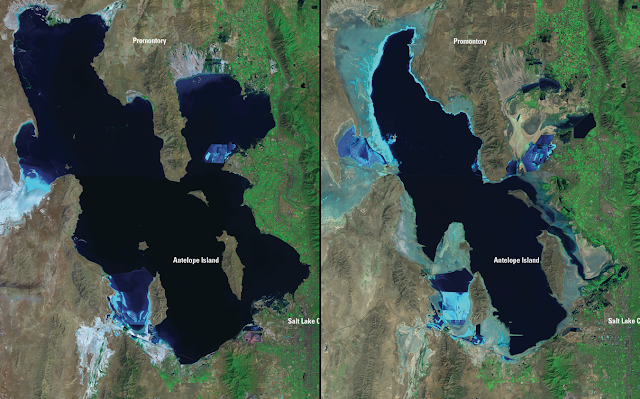
It's a question I am asked repeatedly.  Does size matter for the Great Salt Lake effect? The Great Salt Lake is a terminal lake, meaning that it has no outlet.  The only way for water to escape is by evaporation.  As a result, its size varies during the year, from year to year, and from decade to decade depending on the amount of freshwater inflow. Landsat satellite images of the Great Salt Lake in August 1985 and September 2010.  Source: USGS Landsat Missions Gallery, "Great Salt Lake 1985–2010," US Department of Interior/USGS. In the historical record, the Great Salt Lake at its historic high covered 2300 square miles, whereas at its historic low, it covered only 937 square miles. Source: http://learn.genetics.utah.edu/content/gsl/physical_char/ We are currently near a historic low (see Is the Great Salt Lake Approaching a Record Low Stand ?), so should we expect less lake effect this winter? All else being equal the answer to that question...

The Never Summer Range May Need To Be Renamed

Image
I've been in Colorado this week attending meetings at the National Center for Atmospheric Research and then taking some college tours with my son.  We had time today to visit Rocky Mountain National Park and do some sightseeing and hiking. Although I've never spent any time in them, I've always had a thing for the Never Summer Range, which is just west of the park.  The name appeals to meteorologists, and on top of that, the peaks are named after clouds (e.g., Mount Stratus, Mount Nimbus, Mount Cumulus).  As can be seen below, however, the Never Summers may need to be renamed.  They are virtually snow free this fall. The lack of snow is apparent throughout the Colorado Rockies.  The Andrews Glacier is hanging on, but barely. Let's hope this winter brings the goods big time so we can have a temporary restoration of some of these dying snow fields.   

A Hot Stretch, But Cooler Weather Is Coming

Image
The past month has been quite warm and enjoyable in northern Utah.  If you are wondering where it ranks historically, the answer is quite high.  If we look at the past month (i.e., since September 13), it ranks as the 2nd warmest in the instrumented record. Source: NOAA Regional Climate Centers You might recall that in mid September we had a stretch of cooler, rainier weather.  If we chop off that period and look a the stretch from September 20 to October 13 (yesterday), it is the warmest such stretch in the instrumented record. There are, however, some changes coming.  First, we have a short-wave trough moving in from the southwest on Friday night.  Then we have a another shortwave trough approaching from the west later in the weekend.  Together, these two systems will bring cooler weather and some showers and thunderstorms to northern Utah this weekend.  There probably will be some snow on the high peaks late in the weekend, but unless the on...

The Fall Break Forecast

Image
This week is fall break at the University of Utah.  Several years ago, the students voted to have a full week fall break and each year I thank them for doing so as October is a wonderful month in the Intermountain West. The forecast for fall break week looks pretty good statewide through at least Wednesday.  There is a weak short-wave trough forecast to flirt with the southwest later in the week, as illustrated by the GFS forecast for 1200 UTC (0600 MDT) Friday.   The timing and strength of this trough remain somewhat uncertain and it's main impact will probably be to increase the threat of showers and thunderstorms, especially in southern Utah.  Check forecasts in a couple of days, especially if you are considering canyoneering in the south later this week or over the weekend.   If we look out into the extended, some ensemble members are hinting at the possibility of some precipitation  next weekend or early next week.  For instance, i...

Desperate Times for Meteorologists

Image
The weather of late has been great for recreation, but pretty damn boring if you are a meteorologist. Today's "excitement" involves a trough passage across northern Utah.  It's pretty much cloud free, so we need to dig deep to notice the change. The NAM forecast for this afternoon shows the trough axis at all levels just past Salt Lake City with westerly or northwesterly flow in its wake.   The impact on temperatures is quite pronounced as we've been nearly flatlined late last night and for much of the day today.  This is an indication that the transport of cold air into northern Utah, or what meteorologists call cold advection , is nearly perfectly balancing the rise in temperature from solar heating. Source: MesoWest Although this is a pretty wimpy trough from a moisture perspective, it is bringing in some dust or smoke.  I was on Grandeur Peak this morning and the visibility at low levels was fairly poor over the northwest Salt Lake Valley and th...

Spectacular Weather for ESPN Gameday

Image
ESPN's College Gameday is now on campus and setting up shop in President's Circle just outside my office. The U has really scored on this one.  It's going to be spectacular with mostly sunny skies and temperatures reaching the high 70s today and low 80s tomorrow.  The "natural advantages" of the U should be on full display during the coverage today and tomorrow and conditions will be perfect for the 8 PM kickoff. Professor Powder has delivered the weather.  Now lets hope the Ute football team can deliver a win.  Go Utes!

Still on Track for Strong El Nino

Image
The Climate Prediction Center issued its monthly ENSO diagnostic discussion today and not surprisingly continues to go for a 95% chance of El Nino continuing through winter.  As we've seen for some time, sea surface temperature anomalies show a well-developed El Nino signature with a tongue of anomalously warm water extending across the eastern and tropical Pacific. Source: CPC The International Research Institute for Climate and Society at Columbia University has a nice simple graphic summarizing the El Nino predictions showing a very high likelihood of El Nino conditions persisting through winter before the likelihood of a decline in strength increases in the spring. Source: http://iri.columbia.edu/our-expertise/climate/forecasts/enso/current/?enso_tab=enso-cpc_plume As we've discussed previously, I don't consider the existence of El Nino to have a strong influence on the snowfall odds for this coming ski season in the central Wasatch (see Wasatch Weather Ween...

Eastern Utah Is So Weird!

Image
As noted by David, who commented on the previous post, the valleys and lowlands of eastern Utah are just plain weird climatologically. If one classifies the precipitation climate over the southwest U.S., there are four major regimes.  The first (row a in the image below), covering most of California, northern Nevada, and the upper elevations of northern Utah and western Colorado, features a pronounced winter maximum.  The second (row b), covering much of Arizona and portions of southern Utah, New Mexico, and southwest Colorado, features a pronounced maximum during the monsoon.  The third (row c), covering the plains of eastern Colorado and New Mexico, is somewhat related and has a maximum in the summer with less precipitation in the winter.  Finally, there is a fourth regime (row d) in the lower elevations of portions of Nevada, Utah, and western Colorado where precipitation peaks in the spring.  This includes the Salt Lake Valley. Source: Steenburgh et al...

Stuck Between Two Regimes

Image
Precipitation over the western United States over the next week is strongly dominated by two regimes.  The first is associated with the deep upper-level trough moving across the southwest U.S. over the next few days that will result in frequent shower and thunderstorm activity.  The second develops later this week as moist southwesterly flow penetrates into the Pacific Northwest.   The mean precipitation produced over the next 7 days by the North American Ensemble Forecast System (NAEFS) shows these two regimes quite nicely with the largest accumulations over the Southwest and the Northwest.     NAEFS mean precipitation 0000 UTC 5 October – 0000 UTC 12 October 2015 Northern Utah is just on the fringe of the more monsoonal regime, but misses out on the precipitation over the Northwest.  Thus, our best chance for precipitation in northern Utah is through tomorrow evening as we are brushed by the upper-level trough.   Because we're stuck be...

The Mount Olympus Wilderness

Image
It doesn't matter how long you live in Utah.  You will have days where you are just thankful for the beauty and access of the Wasatch Range. The Mount Olympus Wilderness is a truly remarkable place.  It's right there.  It starts right on the edge of the east bench and is a remarkably wild and undeveloped place.  The vegetation is thick on north aspects and I saw plenty of deer, grouse, and woodpeckers today. The Desolation Trail is aptly named.  Plenty of people take it the first couple of miles, but once you climb a couple thousand vertical feet, you'll find few people. There's still nice color out there, particularly on this side of the range.  I was in Park City last weekend and was shocked at how grey everything was.  Many of the aspens on the Wasatch Back dropped their leaves early this year.  I've heard media reports that a fungus is responsible.  Apparently it's a one-and-done thing and not a long term detriment to tree health...