Wednesday, October 30, 2019

Hell Has Frozen Over

Here are two things that have never been observed before in Salt Lake City in October.

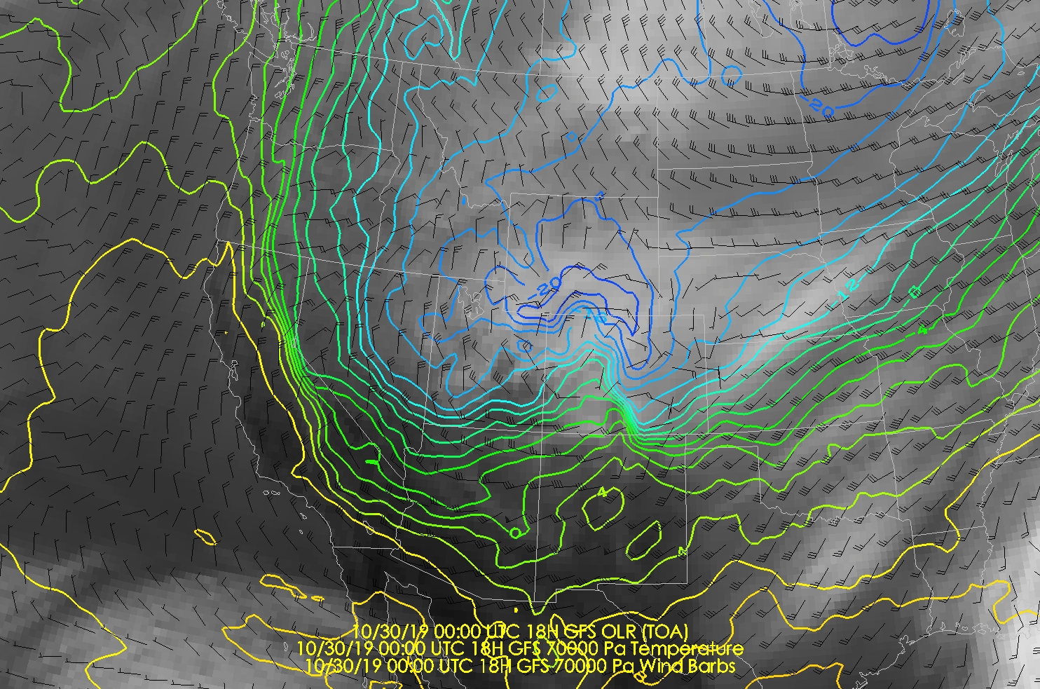
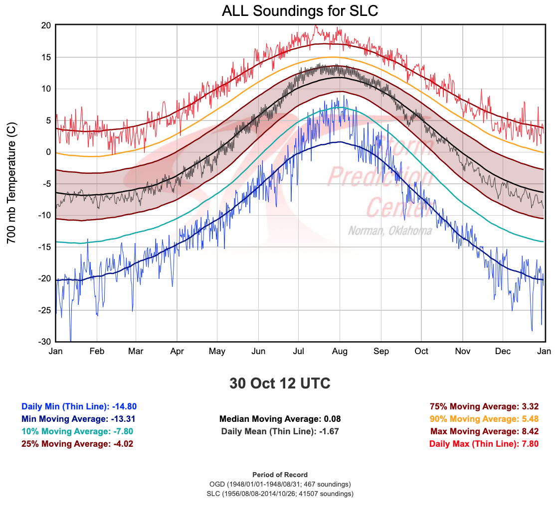
First is yesterday afternoon's sounding, with a 700-mb (10,000 ft) temperature of -18.5˚C, more than 3˚C colder than the previous record of -15.3˚C.

Source: SPC
If you are wondering, temperatures aloft have already started to increase, so this morning's 700-mb temperature is -15.7˚C.  That's not as cold, but it is the 2nd lowest on record.

Second is the overnight minimum temperature of 14˚F, which is the lowest temperature recorded in the month of October in Salt Lake City with records going back to 1874.


Beyond Salt Lake, it was cold everywhere, but as usual, Peter Sink, a sinkhole in the Bear River Range known for extremely low temperatures, takes the cake.  Looks like a minimum temperature of -43.6˚F based on data available in MesoWest.  


Logan meteorologist Timothy Wright tweeted this morning that the minimum was -45.5˚F and that would be a national October record.  The lower temperature he reports could reflect that he has access to another station or data between the obs times reported to MesoWest.  I'm sure he'll get to the "bottom" of this eventually. 
I would rate this event as one of the most remarkable since I moved here in 1995, up there with the 1999 Salt Lake City Tornado and Thanksgiving 2001 Hundred Inch Storm at Alta.  Extreme cold surges are rare events in northern Utah.  This is why, when one looks at the record daily minimum temperature records for Salt Lake City (light blue line below), there are a small number of truly exceptional minimum temperature records with a spike-like appearance.  Examples include February 9-10, 1933, November 3, 1936, and November 15-16, 1955.  There is another period in December during which cold surges in 1932 and 1972 set extreme minimum records from December 9-16.  

http://scacis.rcc-acis.org/
Such cold surges are the meteorological equivalent of drawing a royal flush in five-card draw.  A magic sequence of events must come together to get such extremely low temperatures.  This is especially true given the warming global climate and urban heat island effects.

An alternative perspective on the extreme nature of the event is provided by the analysis below, which is a map of departures of current surface temperatures from the 1979-2000 average for each location (referred to as anomalies).  The coldest anomalies are in western North America, centered over Wyoming.  However, the global average is 0.7˚C warmer than the 1979–2000 average, so global warming is still a thing.  Additionally, patterns that cause cold surgest into the western and central U.S. are often associated with anomalously warm temperatures in Alaska, and you can see that below.  In fact, the high temperature in Anchorage yesterday was 54˚F.

Source: climatereanalyzer.org
If you don't like the cold weather, then you should simply plan on going up to upper Big or Little Cottonwood Canyon tomorrow.  The warming in the mountains over the next 24 hours is going to be remarkable.  At 8am this morning it is -6˚F on the summit of Mt. Baldy (11,000 ft).  By tomorrow it will be close to freezing.  The models are showing more than a 30˚F increase in temperature in the mountains from this morning to tomorrow afternoon.

Tuesday, October 29, 2019

Rapid-Fire Views on the Octobruary Cold Surge

So much to talk about today and so little time.  Hence, I need to do this in rapid-fire mode.

Record Cold Crest-Level Temperatures

Forecast 700-mb temperatures for Salt Lake City at 0000 UTC 30 October (1800 MDT Today) are -17.7˚C by the NAM and -18.1˚C by the GFS.  These are slightly higher than advertised a few days ago, but will still represent records in the upper-air sounding record for the month of October.

Record Cold Surface Temperatures

The NWS forecast of 13˚F for tomorrow (Wednesday) morning would be the lowest temperature ever recorded at the Salt Lake City International Airport in October.  I haven't bothered to see what the records are elsewhere, but the current forecast (image grabbed at 7:30 AM MDT Tuesday 29 October) calls for -11˚F in Randolph and, gasp, 24˚F in St. George. 


Snow

Yeah, it's happening today.  Monitor forecasts.  'Nuff said as I don't have time for a proper forecast.

Back-Door Cold Front

In weather and war, bad things come from the east.  If you think it is cold now, the HRRR is advertising the passage of a so-called back-door cold front across the Wasatch Front this afternoon.  A back-door cold front is one that comes from the east rather than the west or northwest.  The HRRR forecast valid 2100 UTC (1400 MDT) this afternoon shows the front with a precipitation band just to the west and south of the Great Salt Lake.  This front is not approaching from the west, but rather it passed through the Wasatch Front from the east. 


Downslope Wind Misery

This afternoon has the very real potential to be the most miserable October afternoon ever along portions of the northern Wasatch Front.  In the wake of the back-door cold front are easterly downslope winds. 


So, we're talking the coldest October airmass ever, with strong winds.  Excuse my sarcasm, but it's going to be really cold, but at least it's going to be windy too!

Crest-Level Whiplash

As remarkable as this cold air is, the rebound to warmer air, at least in the mountains, is also amazing.

The GFS forecast valid 0000 UTC 30 October (1800 MDT Today/Tuesday) calls for 700-mb (crest-level) temperatures of -18˚C over Salt Lake City.  However, the warm air moves in quickly aloft and by 1200 UTC (0600 MDT) Thursday/Halloween, they have climbed all the way to -1˚C. 


Late October Inversion

This is a hypothesis worth checking, but the result of that warming aloft will probably be one of the strongest, deepest inversions on record on Halloween.  The word inversion is often used in Utah to mean pollution, but here I'm referring to the temperature inversion that will develop over northern Utah as that warm air moves in aloft.

Forecast soundings from the NAM show a surface-based inversion at 1200 UTC (0600 MDT) Thursday/Halloween morning with surface temperatures near -9˚C, whereas temperatures at 675 mb are around -3˚C. 

Inversion season "starts" on November 1, but Mother Nature is going to get started early.  Even by late afternoon on Halloween, only a shallow surface-based mixed layer exists, with constant temperatures from 800 to 700 mb near 0˚C.  Technically, this is not an inversion since temperatures do not increase with height, but that's a meteorological nuance.  It's an extremely stable atmosphere with cold air trapped in the Salt Lake Valley. 
Air Pollution?

Probably not an issue for Halloween (Thursday).  I suspect there will be haze around, but air quality should be "good" or at worst low moderate at worst since we will have just flushed the valley with a pristine arctic airmass.  Another brush by system on Friday should ensure that we don't start the inversion season with a major air pollution event.

Conclusion

Beware when the atmosphere is in outlier mode.  That's my go-to phrase this fall. 

Monday, October 28, 2019

How Hell Freezes Over

October is the new January, at least in Salt Lake City where if you think it is cold this morning, just wait.

Really, the past month has been quite cool relative to climatological norms.  The mean temperature at the Salt Lake City International Airport for September 27 through October 27 was 49.8˚F, the lowest mean for that period since 1982 and the 4th lowest on record at the Salt Lake City International Airport (records back to 1928).

Source: http://scacis.rcc-acis.org/
The reason for this cool weather has been a persistent, long-wave, upper-level pattern featuring ridging over the Gulf of Alaska and troughing over the northwest United States.  This has led to northwesterly flow over the western United States, with a series of systems dropping into our area from the northwest or north.

Source: NOAA/ESRL
Yesterday, steady light snow fell along the east bench in the wake of the first of two major upper-level troughs that will plunge us into a deep freeze this week.  Snowfall rates were perfect for creating lovely scenes without too much impact on roads or trails.


This morning, we had a minimum temperature of 22˚F at the Salt Lake City International Airport, a new record for the day.  Minimum temperature records have become relatively rare, so this is cause for celebration.  Hooray!

However, this is just the tip of the spear of the cold air as another system pushes in tonight and tomorrow, which will really make it feel like hell has frozen over.

Believe it or not, the circumstances leading to this deep freeze involve typhoon Neoguri, the remnants of which were off the coast of Japan at 0000 UTC 23 October (circled in red).


Neoguri then underwent extratropical transition and greatly perturbed the midlatitude jet stream, building a high amplitude ridge over the eastern Pacific.


The amplification of this ridge (identified at 1200 UTC 27 October by a red line in the image below) led to an amplification and southward "digging" of the downstream trough over the western United States (long brown dashed line below), giving us yesterday's snow.  This process is known as downstream development.


But Neoguri isn't finished yet.  If you look at the image above, there is a second short-wave trough over the Northwest Territories (brown dashed line), and it is coming to Utah tonight and tomorrow.

The analysis below shows the situation at 700 mb (about 10,000 ft above sea level) a day earlier at 1200 UTC 26 October or 0600 MDT Saturday morning.  The cold front associated with the first upper-level trough was just north of Utah.  Cold air associated with the second upper-level trough (circled in red) was north of Alaska.


Now let's put that into motion. The cold front pushes through Utah, and then, the really cold air associated with the 2nd trough moves southward and into the state.


The GFS forecast valid 0000 UTC 30 October (1800 MDT Tuesday) calls for 700-mb temperatures of -19˚C in Salt Lake City.  As noted in an earlier post (A Scary Forecast with Halloween Approaching), temperatures that cold have never been observed in October at the Salt Lake City Airport (upper-air records dating back to the mid 20th century). 


The NWS forecast for the Salt Lake City International Airport thus is calling for a low Tuesday night of 13˚F. 


The record low for the month of October is 16˚F. 

Indeed, this is as close as you can get to hell freezing over. 

And, for God's sake I leave you with this PSA.  TURN OFF YOUR SPRINKLERS. 

Sunday, October 27, 2019

GFS 1, NAM 0

It's a beautiful Octobruary day in the Avenues and on the University of Utah campus where light snow is falling and creating a beautiful scene with the fall colors.  My little corner of northwest campus is especially nice where the University has gardened with drought-resistant plants.  So much nicer than grass!


This morning, I took a look back at the forecasts produced by the models initialized at 0000 UTC 27 October (1800 MDT Saturday).  The contrast between the GFS and the NAM is significant.

Below are 24-hour accumulations (water equivalent) generated through 0000 UTC 27 October (1800 MDT this afternoon).  The GFS (top) has about .1-.25 inches falling over the Salt Lake Valley, with higher amounts in the central Wasatch.  The NAM (bottom) has nothing.   


Downscaling and applying a snow-to-liquid ratio to these forecasts and you get accumulations of 0.5 to 2 inches on the benches and greater than 4 inches over the central Wasatch from the GFS.  Nothing from the NAM (naturally). 


If you are wondering, automated sensors at Alta-Collins suggest 3-4 inches of snow as of 10 am.  Accumulation in my neighborhood is surface dependent, but I'm willing to call it measurable and thus give the GFS a 1-0 win over the NAM. 


So, in this instance, yesterday afternoon's guidance from the GFS was superior.  However, that's a sample size of one.  We'll see how it does in the coming weeks.

Saturday, October 26, 2019

A Scary Forecast with Halloween Approaching

I'm putting in some time at the office today and just took a peek at the models. 


Yup, they are terrifying, with an airmass coming in that is NOTHING like anything we have seen in northern Utah since weather balloons began to be launched in the middle of the 20th century.  If you miss the cold of the old days, Mother Nature is going to be giving you a taste.

The GFS forecast for 0600 UTC 30 Oct (0000 MDT Wednesday) shows 700-mb (10,000 ft) temperatures near -20˚C across much of northern Utah.  You can even find sub -24˚C air near the Uintas. 


These numbers are utterly, totally, and completely ridiculous.  In the sounding archive for northern Utah, there has NEVER been a 700 mb temperature observed below -15.3˚C in October. 


It is not hyperbole to say this is an unprecedented early season cold surge during most of our lifetimes.  According to the NWS Salt Lake City Forecast Discussion, the European ensemble forecast mean 700-mb temperature is -19˚C at 1200 UTC (0600 MDT) Wednesday morning. 

It's going to be a cold halloween.  Yes, it will be important to keep the kiddies warm, but this is also a situation where the homeless will be at serious risk.  Prep your house and car if you haven't already and pick any vegetables you have remaining. 

Finally, monitor official forecasts.  Much is going to depend on the exact track and strength of the synoptic systems responsible for the cold surge, but portions of northern Utah could see some snow (and with such low temperatures, it is going to stick) and it is possible that we could see downslope canyon winds as well. 

#WINTERISCOMING

Friday, October 25, 2019

Old School Snow Studies

This month marks the 100th anniversary of the October 1919 issue of Monthly Weather Review, which included a whole slew of short articles on snow and its impacts.  Lovers of snow and history can check it out at https://journals.ametsoc.org/toc/mwre/47/10.

Included is a map of the average annual snowfall of the United States, 1895–1914 by C. F. Brooks based on observations from 2,000 stations.  My view is it's a pretty good synthesis, especially over the eastern 2/3 of the U.S.  The "natural advantages" of the Cottonwood Canyons, remain undiscovered.

Source: Ward (1919)
There's also an article on a "improved form of snow sampler," which is basically a snow coring tube similar to those still in use today.

Source: Kadel (1919)
At the time, Monthly Weather Review often included abstract reprints from other journals.  The issue includes this synopsis of the snow climate of the European Alps by M. E. Benevent.
"The region naturally falls into two main subdivisions — the North-Alps, whose precipitation is controlled by oceanic influence, and the Southern Alps, controlled by Mediterranean influence.  
Well, that's a start. 

I wonder how scientists will look back on today's atmospheric research in 2119?  I suspect that most of our work, while enabling the progression of science to where it will be in 2119, will be subsumed by newer and better studies that build upon the knowledge we create today.  Scientists will look back and see the value, but only a small percentage of papers published today will have significant value.  If you think about it, that is actually a very optimistic view of the future of atmospheric research.  

Wednesday, October 23, 2019

Welcome to the "Facet Factory"

The pattern for the next week is looking like one that will be relatively cool and mainly dry. 

Medium-range forecast models indicate that ridging will persist to our west, allowing systems to drop in over Utah from the north or northwest.  These systems will usher in cool air, but are pretty dry, with limited precipitation.

The first passes today, although you may barely notice it.  Most of the moisture remains to our east, with the Uintas and maybe the Bear River Range seeing a few flakes.  The Salt Lake Valley will remain dry and if there are flakes in the central Wasatch, they won't add up to anything. 


There's no well-defined front, but cooler air will filter in and it will lead to lower high temperatures today and a minimum near freezing at the Salt Lake City airport tomorrow morning.

The next system pushes in Saturday.  This is a stronger system thermodynamically, meaning the temperature contrast is larger and sharper.  However, it is also moisture starved by the time the airmass traverses ranges to our north and east.  Thus, mountain snow showers, which are most likely in the wake of the front Saturday night or Sunday, should be limited. 

 
There are, however, a few outlier members of the NAEFS, specifically from the Canadian Ensemble, that call for a bigger event.  Given that this is a tricky case of downstream development, which can sometimes throw a wrench into the system, I won't rule that out, but I think the odds are quite low. 


Thus, as one of my graduate students said yesterday, the Wasatch look to be a facet factory over the next week with generally cool or cold weather, frequent clear skies, and a thin snowpack leading to large snowpack temperature gradients and snow metamorphism into weaker, faceted crystals. 

This will be something to pay attention to in the coming days and weeks as it will likely affect avalanche conditions, including when we start to see more significant storms again. 

Apologies to my friends at the Utah Avalanche Center...

Monday, October 21, 2019

Innsbruck Winter Itinerary

Since returning from a nearly 6-month stay in Innsbruck in July, hardly a day goes by when I don't wish I could teleport back to enjoy the mountains and culture of the Tirol.  I get occasional e-mails for travel tips, so below is a one-week itinerary, written with just enough detail to give you ideas.  While written as an itinerary, any trip would involve adjustment for weather and snow conditions.  Thus, it is mean to be sampled rather than followed. 

I'll begin with some general tips.  Although a car could be convenient for getting to resorts and trailheads, it a liability in town where you are usually better off walking.  If you rent one, you want to be sure you have options for parking wherever you are staying.  Additionally, some ultra cheap rental car deals look great, until you show up to pick up the car and find out you need to pay extra for cross-border travel, insurance, tolls (yes, there are many and you should check out what is and isn't covered with your rental car and be specific). 

If you decide to go to Innsbruck, you should realize that its primary advantages are variety, centrality, and culture.  There is no destination ski area next to Innsbruck.  You're going to spend some time traveling.  If you want a destination ski resort experience, especially one that maximizes the potential for a powder dump, you're probably better of staying in the Arlberg (e.g., St. Anton, Stuben, Zurs, Lech, Warth). 

Finally, "know before you go".  In addition to the need for avalanche safety in the backcountry, off-piste resort skiing in Europe is largely uncontrolled and should be treated as such. 

Day 1: Intro to Innsbruck

You've probably arrived after a long trip from the States.  Chances are your jet lagged and beat whether you've come in via plane, train, or shuttle.  Enjoy an easy day walking around old town.  See the Golden Roof and check out some of the well stocked but expensive adventure sports stores like The Sportler (stores closed on Sundays).  If you want some history, find your way to Schloss Ambras.  If you need rental gear, find Die Borse, which rents alpine skiing and alpine touring gear.   For dinner, find Gasthaus Anich and get the gröstl, a Tirolean meat, egg, and potato hash, with a weisbier hell (light) or dunkel (dark). 

Day 2: Stretch the legs

Catch the J-line bus to Patscherkofel, the ski area south of Innsbruck.  Your skis are your bus pass as skiers are free.  It's a picturesque 30-minute trip.  Bring your AT skis and skip the line for passes.  Skin up the resort, which is AT friendly.  Start to the west of the lower rope tow and head up.  There is a steep stretch above the rope tow that will require you to traverse to the east side of the run.  It can be difficult if icy.  Follow the locals (you'll usually have uphill company).  It's a bit over 3000 vertical feet to the top of the resort.  Enjoy lunch at the Patscherkofelhaus, the old stone building east of the cablecar building.  Or, if you are up for it and the route is open, skin and have an espresso, coffee, or tea at the Patscherkofel Gipfelstube on the summit first.  After lunch, descend via the downhill route made famous by Franz Klammer in the 1976 Olympics.  Practice your edging skills.  This is a north facing resort in Austria.  If it is in the afternoon and it hasn't snowed in a while, you're going to need them.

The Patscherkofelhaus (left), Innsbruck (right), and the Inn Valley
Day 3: Alpine ski like a local

Catch the L1 bus to Axamer Lizum, an alpine resort southwest of Innsbruck.  If it's a weekend, get it at one of the stops before the University.  It's about a 45 minute trip to the ski area, which is modest in size, but good for a day of skiing.  When you need a break, stop at the summit Hoadl House at the top of the Olympiabahn funicular and check out their pastry bar. 

Axamer Lizum
Day 4: Skate ski Seefeld

Catch the train (30 minutes) from Innsbruck to Seefeld and skate ski at the site of the 2019 Nordic World Championships.  There are something like 400-km of cross country trails on the plateau on which Seefeld sits, so there's more here than you can ski ina week.  Find a hutte or stube to stop at for lunch.  One option is the Möserer Seestubin.  After returning to Innsbruck, catch a cab to Gasthaus Planötzenhof for dinner.  

Seefeld area ski trails
Day 5: Run of Fame

Double down on the train travel and ride the rails to St. Anton.  Make sure it's an early one.  After exiting the St. Anton train station, walk 5 minutes to the Galzigbahn and ski the Run of Fame from St. Anton to Warth and back.  It will take you all day.  Make sure it's a sunny one.  Bring your wallet and be prepared for crowds if it is high season.  Nothing is cheap in the Arlberg.  

Above Zurs on the return to St. Anton
Day 6: Nordkette

Chance are you need a recovery day.  Ride the Nordkettebahn to the top of the Nordkette, the "northern chain" of mountains above Innsbruck.  This involves taking the funicular from old town and then two trams.  Have a coffee or beer at Seegrube.  Enjoy the views.  By now you're getting tired of Tirolean food, so dine at a Nepalese restaurant like the Everest Inn and drink some craft beer at Tribaun.

Looking down towards Innsbruck from near the top of the Haflekar tram in April
Day 7: Ski tour

Find a local guide or rent a car and make your own plans via bergfex.com and do a ski tour in the Sellraintal or the side valleys off the Wipptal.  As usual, know before you go.  

Ski touring in the Alps south of Innsbruck

Sunday, October 20, 2019

Morning Storm Update

The Alta High Rustler cam is looking quite wintery this morning.

Source: Alta Ski Area
This is technically, based on my 10 inch minimum requirement, the first deep powder day of the 2019/20 ski season.  As of 0800 MDT, Automated snow sensors at Alta-Collins show an increase of about 13 inches since yesterday afternoon, bringing the total snow depth to 18 inches (note that the snow depth sensor is reading 4 inches too high).

Source: MesoWest
Sadly, that's below my tolerance levels, so my plan is to sit this one out assuming something really exciting doesn't happen this morning.

Much of the water and snow came with the frontal system – the same one that created a deluge at Rice-Eccles Stadium.  If my math is right, Alta got about 0.92" of water and 9 inches of snow through 9 pm.  After that, post-frontal snow showers added some additional low density snow.  

Although there was some evidence of lake enhancement at times, a strong lake band never really got going.  The dominant signature overnight was one of orographic snow showers, not only over the Wasatch, but also over the Bear River Range near Logan.  This pattern continues this morning, as can be seen in the radar image below, although snowfall rates are tapering.  

Source: NCAR/RAL
All of this puts us into purgatory.  Upper elevation hiking is difficult due to the snow depth, but the snowpack is still fairly shallow for skiing.  I'm sure some people will get out on this, and the higher density snow received last week and during the frontal passage late yesterday and last night will at least be supportable.

Another major storm would be a came changer.  However, the NAEFS ensemble shows, after last night storms, just a couple of quick hitter small events over the next seven days.  


Let's hope one of those storms comes through bigger than advertised or that in the aggregate, the inches add up.  

A quick note that early snow can still pose an avalanche risk.  See the PSA below from the UAC.  A concern in the coming weeks, should we not continue to build a snowpack, would be that the snow facets, and we put new snow on top of it, leading to a monsters in the basemen scenario (just in time for Halloween).


Friday, October 18, 2019

Assessing the Likelihood of Weekend Skiing

The likelihood of skiing this weekend is dependent on several factors, including how much snow the next storm produces, your willingness to sacrifice p-tex, and your tolerance of bodily harm. 

I'll focus on the former, beginning with where we are right now. 

Prior to last nights storm, snow cover in the Wasatch was scant.  The Alta web cam at the top of Collins shows just a few patches of snow left over from last season.

Source: alta.com
Last nights storm, however, produced near the top of expectations at upper elevations.  Radar imagery below shows the passage of the frontal system across the area with initially scattered showers followed by a well organized precipitation band. 


As a result, Alta is covered by a blanket of white. 

Source: alta.com
Automated observations from the Alta-Collins site show a total of 0.62 inches of water.  I suspect that the initial snow depth yesterday wasn't actually 4 inches and that this reflects a calibration error.  However, overnight, the total snow depth increases 8 inches and the interval snow depth (measured on a board) goes up 6 or 7, the latter being the peak right at the end of the storm before settlement.  Based on the mean, we'll call it 7 new with 9% water content.

Source: MesoWest
Other than perhaps a flake or two this morning, it should be dry through tomorrow (Saturday) morning.  Then the next upper-level trough and frontal system approach, with the chance of precipitation with a snow level near 6500 feet increasing in the afternoon.  The NAM forecast valid 0000 UTC 20 October (1800 MDT Saturday) shows precipitation from the previous 3 hours down to roughly the Cottonwoods.  


Passage of the trough will result in a lowering of snow levels to the valley floor Saturday night.  The models are producing both orographic and lake effect snow in the post-frontal northwesterly flow late Sunday night and Sunday morning.  The example below is from the NAM at 1200 UTC (0600 MDT) Sunday morning.  


Models like the NAM don't adequately resolve the influence of the lake or mountains, but this is a scenario where the likelihood of lake effect is higher due to the relatively warm lake (about 11.5˚C) and forecast for a relatively cold and moist post-frontal flow.  

Our downscaled forecasts based on the SREF are generating 0.25 to nearly 2.2 inches of water and about 4 to 35 inches of snow at Alta Collins through 1800 UTC 20 October (1200 MDT Sunday).  For snow, most of the members lie between 10 and 20 inches.  


Ultimately, the forecast distribution is one that I would describe as "heavily skewed."  There is a high likelihood of something in the 6-10 inch range, but a long skinny tail of lower probability outcomes with greater amounts.  Something on that long skinny tail verifying above 12 inches will require Alta to be in the cross hairs of well organized post-frontal convection or lake-effect.  

The bottom line is that this is an event worth watching.  A likely outcome is that the snow from this storm, combined with that from last night, will push the total snow depth to something like 10 to 16 inches by 1200 MDT Sunday.  Given that's all relatively fresh, unsettled snow with a limited water content, it's certainly below my threshold for skiing, and it should be below yours too.  

On the other hand, if all the ingredients came together — the trough track is right, the post-frontal and lake-effect convection goes big, and the central Wasatch are in the cross hairs — this could be a more significant storm.