Friday, December 31, 2021

2021 Ends with a Bang


As of 7 AM this morning, Alta-Collins has had 22 inches of snow since 10 AM yesterday with 2.08 inches of water.  Total snow depth is now at 96 inches, putting us at the precipice for Steenburgh Winter (100 inches at Alta-Collins before 10 February).  

A big contributor to the water totals was an intense snowband that setup in the southwesterly flow along the Alpine Ridge between Little Cottonwood and American Fork Canyons.  Below is a screenshot showing the band at 23:43 UTC (4:43 PM MST).  

From 2300–0200 UTC (4-7 PM MST) Alta-Collins recorded 1.06" of water equivalent snowfall, including 0.42" in the hour ending at 0100 UTC (6 PM MST), for an average of 0.35" per hour.  Anything at or above 0.3" really gets my attention as being out there for Little Cottonwood Canyon.  The Alta-Collins snowstake camera at 6:12 PM MST showed a dome-like pile of large graupel consistent with strong convection within the band.  


Little wonder that SR-210 turned into a cluster yesterday afternoon or that the canyon was closed last night.  

I've seen similar bands setup in southwest flow on a few occasions, but don't understand the mechanism for formation. At times, the radar imagery suggests a connection to the southwest end of the Oquirrh Mountains.  You can see in the radar image above that radar echoes ≥ 30 dBZ extend all the way to Point of the Mountain and there's a hint of something extending all the way to Cedar Fort.  

Thus, I don't think these bands solely reflect lifting by the Alpine Ridge.  My guess is that the band is initiated by flow interactions with the Oquirrh Mountains, but amplifies downstream over the central Wasatch.  This has been shown to occur in other regions where ridge-gap corrugations in topography can lead to the development of precipitation bands downstream of the mountains, such as illustrated below for the Alps.  

Source: Siedersleben and Gohm (2016)

Under the right circumstances, the small scale circulations induced by flow interactions with these ridge-gap corrugations can lead to instabilities that result in band formation.  The end of a mountain range can also produce such circulations and perhaps that is the case sometimes for the southern tip of the Oquirrhs.  

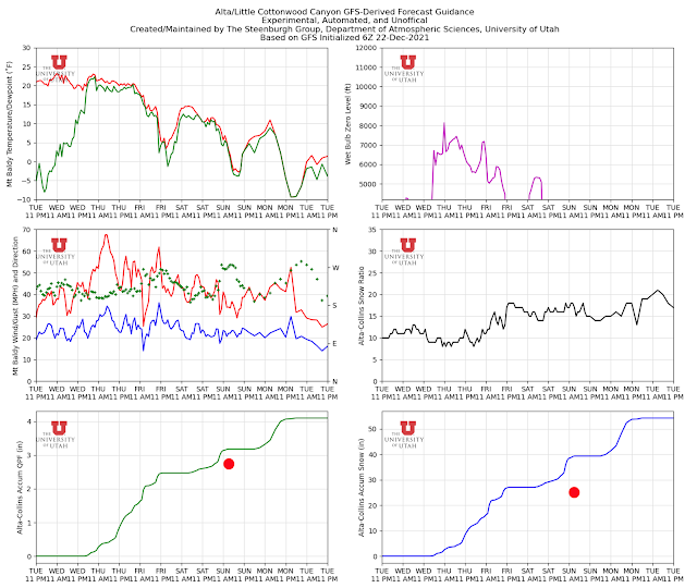
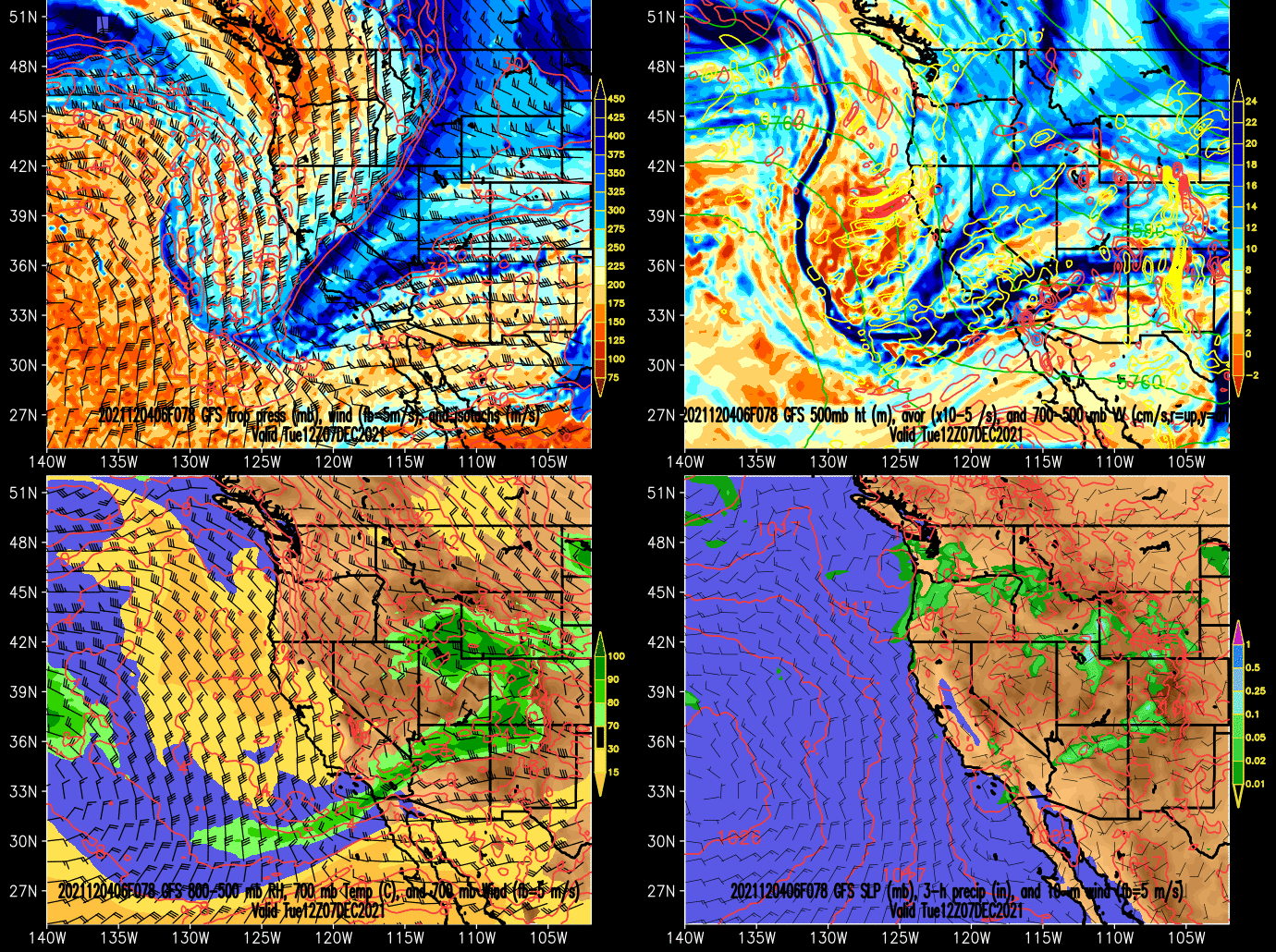
Meanwhile, as of Friday morning, we are transitioning into the unstable, postfrontal phase of the storm.  A time-height section from the GFS shows this persisting into Saturday morning when a layer of stable, dry air associated with the upstream ridge moves over Utah.  Flow directions from today through then at crest level (700 mb) are generally from westerly to northwesterly.  I'd like to see things locked in at northwesterly, but we should see periods of snow in the Cottonwoods regardless and a chance of lake-effect late tonight and tomorrow morning.  

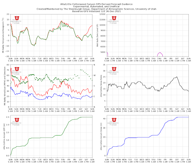
It's worth a look at the GFS-derived forecast guidance for upper Little Cottonwood.  Temperatures on Mt. Baldy (11,000 ft) drop steadily today and tonight, bottoming out at -13˚F tomorrow morning.  The NAM and GFS forecast 700-mb (10,000 ft) temperatures to bottom out at -20.5˚C (-5˚F) and -20.1˚C (-4˚F) tomorrow morning as well.  Anything below -20˚C is very cold for northern Utah.  Bundle up!  

The GFS water-equivalent total for 9 AM this morning through 9 AM tomorrow morning is 0.32" and about 6" of snow.  We are solidly in the post-frontal crapshoot for this one.  Unstable flow is good, although it's not always solidly northwesterly in the forecast.  By tomorrow morning, temperatures are low enough that we might see the best zone for snow growth shifting to below upper-elevations.  Dendritic snow growth occurs at temperatures between -12 and -18˚C and we'll be colder than that above 10,000 feet.  Did I mention the lake?  Yeah it's another possibility.  Finally, the snow we get today and this evening should be of the cold-smoke variety, so it won't take much water to give a big snowfall. 

I'm going to go for another 8-14" of snow at Alta Collins from 9 AM this morning to 9 AM tomorrow morning.  If that comes through, there's a pretty good chance that New Years Day will also be the official start of Steenburgh Winter.  

Thursday, December 30, 2021

Snow and Storm Snippets

 A few thoughts on snow and weather as we approach the last weekend of the holiday period.

  • It's been a decent week for skiers like myself who aren't interested in warm weather and bluebird skies.  Conditions at Mountain Dell and Round Valley have been good for skating and I've had a couple of good tours in low-angle trees as well.  
  • I normally exile myself from the Cottonwood Canyons during the holiday week, but toured twice in Big Cottonwood, finding no lineup at the bottom and parking for our group at Spruces.  This is a small sample size, but the traffic has seemed surprisingly manageable.  Perhaps pay-to-park or the lack of sunny skies has helped.  Things may change tomorrow when the Wasangeles Snakers may be coming back to town after tonight's big dump.  There may also be <gasp> sun this weekend, especially on Sunday.  
  • Snowpack relative to median in the central and northern Wasatch is either near- or below median depending on location.  Snowbird has the most robust snowpack of any SNOTEL station in the central and northern Wasatch.  Thaynes Canyon also running a bit above median.  The rest are below median (this is as of last night so a bit of the overnight snowfall isn't captured).  
  • It's looking like a Greatest Snow on Earth special for tomorrow.  There will be mountain snowshowers today, and then widespread snow developing this afternoon and evening as a front moves through the area.  Looks like a pretty good event for all elevations.  Through 9 AM tomorrow morning, the GFS and NAM are going for 13" and 17" respectively at Alta-Collins with water contents in the 6-8% range.  I'll go for 12-18" through 9 AM tomorrow.  Additionally, this will be an all-elevations storm and Mountain Dell should benefit too.  Monitor forecasts and road conditions if you need to travel.  
  • Following the front, we have a prolonged period of cold-unstable air through Saturday morning with a cold upper-level trough moving over Utah Friday night.  It's a crapshoot exactly how things will play out, but additional accumulations look likely for at least the Cottonwoods.  
  • Saturday morning looks to be the end of this storm cycle with a ridge building over Utah for Sunday.   Right now, the extended pattern looks progressive, so the ridge won't be long lived.  Let's hope more storms follow. 

Tuesday, December 28, 2021

WTH Is a Snow Squall?

The term snow squall has recently and forcefully entered the vernacular of Utahns as a series of strong cold fronts with intense bursts of snow and wind have moved through northern Utah over the past few days.  The most recent was yesterday afternoon.

Credit: Andrea Steenburgh

It promoted the issuance of snow squall warnings by the National Weather Service.  


I received notification by cell phone and saw a very detailed discussion of its movement through the metro area by broadcast meteorologists, which is exactly what one would hope would happen to alert people to the rapid change in weather and road conditions.  

Snow squalls are not new phenomenon.  The term is commonly used in the northeast United States where snow squalls can be produced by fronts, lake-effect storms, and other phenomena.  Here in Utah, it has sometimes been used to describe bursts of snow associated with lake-effect storms, but less commonly to describe bursts of snow associated with cold fronts, as occurred yesterday.  Why the change?  

First, let's define snow squall.  Per the National Weather Service Glossary a snow squall is "an intense, but limited duration, period of moderate to heavy snowfall, accompanied by strong, gusty surface winds and possibly lightning."  Technically, the criteria for the issuance of a snow squall warning include visibility of less than a quarter of a mile, subfreezing ground/road temperatures, expected duration of less than 60 minutes, and dangerous and life-threatening conditions.  Such squalls can be a major hazard for road travel and aviation, but also for anyone who may be outdoors.  

Banacos et al. (2020) describe the development of the NWS snow squall warning.  The NWS used to issue special weather statements for snow squalls, but found they did not result in the same level of urgency as a warning.  During the winter of 2017-18 the NWS introduced and did an operational demonstration of snow squall warnings at six weather forecast offices.  It was then operationalized across the United States in the winter of 2018–19.  

Utah cold fronts are sometimes accompanied by snow-squall conditions, including rapid and dramatic cooling to sub-freezing temperatures, heavy snowfall, high winds, and in some cases lightning.  Although the term snow squall hasn't previously been used widely to describe such conditions, it makes sense to adopt this change now and issue such warnings to better highlight when hazardous weather conditions will occur.  The warnings can also be used for lake-effect storms and other phenomena that can produce snow-squall conditions.

Sunday, December 26, 2021

Storm Cycle Update

As of 1 PM MST 26 December, Alta-Collins has recorded 25" of snow and 2.78" of water since 0000 MST 23 December.  The meteogram below shows the major storm periods quite well.  

I suspect most people feel the storm cycle has underperformed thusfar, so let's take a look back.  Below is the GFS-derived forecast from our blog post on 22 December.  I've added a red dot on the accumulated precipitation and snowfall traces.  The GFS was going for 3.17 inches of water, about 15% greater than observed.  That's actually not too bad for a single model.  

If we look at the downscaled NAEFS, we're on the low-end, but within the range of forecast water equivalent.    


My view is that the total water equivalent forecast by the GFS and the NAEFS wasn't too bad.  However, there were two important shortcomings.  The first is that the GFS and most NAEFS members called for the storm on Thursday and Friday to be much larger than observed.  The GFS, for example, produced 2.5 inches of water compared to about an inch observed.  In contrast, today's storm was to be smaller.  Two wrongs have helped to make a right and the weaker first storm was disappointing.  

Second, the snow-to-liquid ratios were overdone, which exacerbated the water equivalent overforecast even more.  As a result, the GFS snowfall forecast was 39", 56% greater than observed and all members of the NAEFS forecast too much snow compared to observed.  

Thus, it is OK to be disappointed, but not too disappointed.  The parade of storms continues and we have another cold front moving through the central Wasatch late tomorrow (Monday) afternoon and evening.  The GFS forecast below puts the front right over the central Wasatch at 0000 UTC 28 December (5 PM MST Monday).


After a break tonight, the models generate about 0.5 to 0.75" of water and 9-15 inches of snow through 11 PM Monday night, with snowfall heaviest around the time of frontal passage late tomorrow and early tomorrow evening.  I like a total for that period of 8-16" at Alta-Collins.  In the wake of the front, temperatures will likely be the coldest of the season so far.  Temperatures dipped to -5˚F at the top of Mt. Baldy in mid December, but the latest forecast is pushing it down to -10˚F Tuesday morning.  


Cold smoke will be had Tuesday morning, but bundle up!

Wednesday, December 22, 2021

It's ON!

The model forecasts for the next "sevenish" days are about as good as I've seen in a long, long time.  

The downscaled NAEFS product has action starting during the day tomorrow (Thursday) and the pattern remaining active through the period we generate forecasts for, which ends at 0000 UTC 29 December (5 PM MST Tuesday 28 December).  

Through that time, the driest ensemble members generate almost 4 inches of water equivalent and just over 50 inches of snow.  The wettest put out ridiculous numbers around 10 inches of water and 150 inches of snow.  

This product has been on the wet side this year, but lets pessimistically cut these numbers in half.  That gives a range for water of 2-5 inches and snow of about 25-75 inches, with ensemble means of about 3 and 50 inches.  Wunderbar!

Our GFS-derived forecast for upper Little Cottonwood is generating just over 4 inches of water through 11  PM Tuesday, which converts to just over 50 inches of snow.  The Thursday and early Friday part of the storm will be mild.  Precipitation in the valley will be of the liquid variety and I'm concerned about negative impacts on snowpack at Mountain Dell during that period as it will probably see some rain at times.  At upper elevations (e.g., Alta) the snow will be a bit on the heavy side.  After Friday, temperatures fall and snow-to-liquid ratios increase, meaning drier snow.  

Meteorologists can be like artists in that we fall in love with our models.  However,  this looks to be a very productive storm period.  It will transform the ski conditions at the resorts, but also exacerbate the backcountry avalanche hazard.  

Monday, December 20, 2021

An Active Holiday Week Ahead

The upper-level pattern is setting up to make the holiday week a stormy one in northern Utah.  

Below are the average 500-mb height anomaly forecasts from the GEFS ensemble valid at 0000 UTC 25 December (5 PM MST 24 December) and 0000 UTC 29 December (5 PM MST 28 December).  The 500-mb level is a good proxy for the upper-level flow.  Anomalies are departures from the long-time average 500-mb heights.  Positive anomalies indicate anomalous ridging, negative anomalies anomalous troughing.  The images below show persistent ridging over the central Pacific and troughing along the Pacific Coast, a pattern that can be very good for northern Utah snowfall provided it doesn't become too amplified (i.e., the trough along the west coast becomes too deep).  


Source: NOAA/ESRL/PSD

Consistent with the upper-level pattern, our downscaled NAEFS ensemble product for Alta-Collins shows a major shift in the pattern beginning around Thursday December 23rd.  Until then, high pressure will predominate, but after that, the pattern becomes quite active.  


The NAEFS mean water-equivalent and snowfall through 0000 UTC 27 December (5 PM MST 26 December are about 3.65" and 60" respectively.  There is a wide range, but over 80% of the members are producing over 2" and 30".  The downscaled NAEFS seems to have a high bias at Alta this year, but even adjusting for that, this looks like the start of a pretty healthy storm cycle that may continue deep into the holiday week.

Ho ho ho.

Saturday, December 18, 2021

Snowpack Realities

Sorry to be Donnie Downer here but regardless of how much snow there might be in the Salt Lake Valley right now, the mountain snowpack situation in northern Utah remains well below median except on north aspects in Little Cottonwood Canyon and the south side of the high Uintas.  The latest numbers from NRCS SNOTEL stations show we are at 69% of median in the Jordan/Provo/Utah Lake basin, 69% of median in the Weber River Basin, and 68% of median in the Lower Bear.   Northern Utah stations at or above median include Mining Fork in the Stansbury Mountains, Snowbird, and several sites on the south side of the High Uintas.  

Focusing on the Jordan/Provo/Utah Lake basin, the reality is that the water equivalent of snowfall so far this year has been sufficient to put us at median.  The problem is that some of that snow fell in October and early November and didn't survive.  One can see this in the time series below, which shows several early season storms followed by melt events.  High-elevation northerly aspects did not suffer as much if at all in those melt events, which is why north facing terrain at Alta and Snowbird sits in the cat-bird seat for snow cover right now.  

Upper-elevation, north-facing, backcountry areas in the central Wasatch also hold close to median snowpack, but also weak layers that are now contributing to dangerous avalanche conditions.  Good to hear that the skier below is OK.  

H/T to that party for sharing that video.  

Getting back to the water situation, the mean snowpack water equivalent in the Jordan/Provo/Utah Lake Basin sits at 3.5 inches.  This is about half way between the lowest in the period of record (1.8") and median (5.1") for the date.  Model forecasts suggest it will remain dry through Wednesday.  Assuming that holds, we will lose another inch to median, so we'd be 2.6 inches behind.  It will take a major multiday storm cycle a bit bigger than the one this past week to make up that ground.  

Much can happen in the coming weeks.  The spigot could turn on and we make up ground quickly.  The one thing we know with certainty is that the persistent weak layer that currently exists in some backcountry areas is probably going to be here for a while.  More below from the Utah Avalanche Center.

Thursday, December 16, 2021

Thundersnow

Tuesday night's thundersnow event got quite a bit of attention and is even discussed in this article in today's Salt Lake Tribune.  If you want a deep dive, see An Overview of Thundersnow, and article by David Schultz and James Vavrek that appeared in the journal Weather.  I'm able to access it from my campus office this morning, but there is a chance it is paywalled.  

Thundersnow is uncommon, but if you are looking for it, Utah is actually a pretty good place.  The map below shows the number of thundersnow occurrences across the United States from 1961-1990.  The highest number was in Utah and the adjoining Intermountain West.  The upper midwest and the Great Lakes regions are also favored for thundersnow.  

Source: Schultz and Vavrek (2009)/Market et al. (2002)

Thundersnow is basically a thunderstorm with snow falling at the surface.  The key ingredients are instability, moisture, and lift.  Basically, you need a strong updraft and a cloud with a mixture of ice and liquid water to promote electrification and charge separation.  As noted in the Schultz and Vavrek article, collisions between graupel and other ice particles are thought to promote storm electrification and charge separation.  

In northern Utah, thundersnow can be produced by frontal systems, as was the case Tuesday night, lake-effect storms, orographic storms, or other types of convective storms.  To me, the interesting thing about thunderstorm isn't that it happens at all, but that it doesn't happen more frequently.  

The map above could use updating.  It is based on weather observations collected primarily at airports. A new thundersnow analysis could integrate data from lightning detection networks and radar-derived precipitation type analyses, which would likely result in an improved climatology.  I suspect such an approach would show, for example, a pronounced maximum in thundersnow events downstream of Lakes Erie and Ontario.  One can see the former above, with Buffalo reporting six events, but in the case of the latter, there were no reporting stations east of Lake Ontario.  

As is the case in summer thunderstorms, it is best to move inside if you hear thundersnow.  The ski areas will typically get everyone off the lifts and shut them down during thundersnow events.  Nobody is happy when that happens, as the skiing is often quite good with heavy snow, but it is necessary for safety.  

Wednesday, December 15, 2021

Game Changer

I've been AWOL for a few days attending my daughter's graduation at Arizona State.  It was an outdoor affair with temperatures near 70.  


The transition to Utah on our return last night could not have been much more dramatic.  I figured our 8ish PM flight arrival time could pose problems for both the frontal wind shift and the snow, and when we boarded, I thought it would be close.  Indeed, we had reached Provo when I felt the plane slow and turn and I thought "oh oh."  The front just passed the airport, so they held us while they reworked the landing pattern for the northwest wind.  

I was worried the snow was probably piling up, but eventually we landed in rain.  By the time we reached the Lyft pickup area, it was, however, full on.  The driver picked us up in a GMC Acadia and I thought we might make it home.  Alas, I asked him about the tires and he said he was getting a new set next week!  Not good.  He barely made it to my son's house near the University of Utah campus and I told him that was enough.  We then switched to my son's car and drove home.  Fun times. 

Last night's storm was the storm we were looking for.  On top of the storm late last week, it should make a HUGE difference for ski conditions.  All elevations with decent water totals including 1.3-1.8" in Little Cottonwood tapering to 1-1.2" on the Park City Ridgeline per the Utah Avalanche Center.  It was also an all elevations storm.  About a foot at my place.  Should be really good base for the Nordic types out there.  

It will take me a while to dig out literally and figuratively, so I haven't had a chance to properly peruse the model forecasts.  A quick peek suggests more is on the way for Thursday and Friday.  Our GFS-derived forecast for Little Cottonwood is spitting out another 10 inches or so during that period and snow levels look to be at the valley floor. 

The Snow Miser has returned!  HOORAY!!!

Sunday, December 12, 2021

Quad State Tornado

The Quad State Tornado hit the hometown of one of my students, Dallas McKinney, Friday night.  Dallas shares his perspectives on the event below.  We are all grateful that Dallas' family and friends are safe.  All opinions expressed are his own and not necessarily that of the University of Utah or his current or former scholarship/grant sponsors (NSF/NWS/NOAA/NASA).

Jim

Perspectives on the Quad State Tornado

Dallas McKinney
University of Utah

I wanted to give a brief discussion of the mile-wide (likely EF-5) tornado that hit my hometown of Mayfield, KY Friday night and let everyone know that my family and friends are alright. Although supercells are mesoscale phenomena and tornados are microscale phenomena, they require favorable synoptic environments to spur their development. Attached is the closest sounding from where the tornado formed (Little Rock, AR). Notice the sufficient ML CAPE (~2000), high surface dewpoints (~67), and especially the extreme low level shear. Winds of 100 kts at 300 mb likely mean a jet streak and/or PV wall is occurring over the area leading to large scale synoptic lift. Winds at 700 mb are 60 kts from the SW, which helps to maintain supercell structure by throwing the precipitation and associated cooler, stable air away from the potential supercell’s inflow and mesocyclone (lower rotating part that spawns tornados). Recent research suggests shear in the lowest 250 m above the ground is most important for tornadogenesis. The winds are 5 kts from due S at the sfc and 35 kts from the SSW at 950 mb! Considering a cold front is also slowing pushing through the area providing instability, we have the four ingredients for severe weather: Shear, Lift, Instability, and Moisture (SLIM).

The results are textbook supercell structures with strong, long lived tornados. Here is radar reflectivity as the tornado went through Mayfield carving a mile wide path of destruction through our commercial district. Notice the "hook echo" with a debris ball at its end. There is so much debris that a three point scattering spike (aka hail spike when only hail) extends to the SE of the debris ball. The tornado is at the inflow notch where the debris ball connects to the rest of the supercell and the velocity couplet is strongest.

The last component of any forecast is communication and associated actions. The synoptic forecast was more than adequate with an Enhanced Outlook (3/5) from the SPC and a Moderate (4/5) the morning/afternoon of the tornado outbreak. NWS Memphis and Paducah issued tornado warnings for the entire storm with often over 45 minutes of lead time. An additional Tornado Emergency for Mayfield with another 5 minutes of lead time (smaller red warning box in radar images). Yet, 50 people were killed when sheltering in the factory they worked in, following the NWS protocols of being in a building, interior room, lying or crouched down. Eventually, farmers will probably find the remains of the people whose solidly built houses are now just concrete slabs. I have read of similar situations for other EF-4 and -5 tornado fatalities where people follow these guidelines, which, I think, leads to meteorology as a whole needing to develop a new set of protocols for these extreme storms. Now that we can reasonably foresee such extreme tornado outbreaks hours to days in the future, we could have severe weather days where an entire region could plan to spend a few hours in designated regional storm shelters designed to withstand an EF-5 tornado. People are a society’s most important resource. Would foregoing one day of productivity every few years when an extreme tornado threat arises be worth avoiding a mass casualty event? Similar evacuation actions are taken for wildfires, hurricanes, and floods. Can we institute an action plan for rural, often poor areas in the Great Plains and South? If not, scotch yourself for more tornado fatalities where we sorrowfully stare at each other and think, “We did all we could,” or point our eyes skyward and simply question, “Why?”

Thursday, December 9, 2021

I Love It When a Storm Comes Together


After fits and starts overnight with convective graupel showers, full-blown frontal precipitation has developed over northern Utah this morning and mountain snowfall rates have really gone through the roof.  Observations from Alta-Collins show .09" of water equivalent and less than an inch of snow through 5 AM, but since then, there's been 0.29" of water equivalent and about 4" of snow.  

Radar at 1433 UTC (0733 MST) shows pretty complete coverage over the northern part of the state.  There are a few holes of lighter precipitation, but for the most part, this is as good as it gets for complete coverage in this part of the world.  


In the upper aves, we were just starting to turn to snow at 7:15 AM with trace accumulations on colder surfaces.  This puts the snow level pretty much at 5,000 feet.  


When I got to campus, it was mainly rain with a few flakes mixed in.  

To the north, a look at UDOT cameras shows accumulating snow on cold surfaces in the Layton area.  We should see continued lowering of the snow levels this morning.

There's no real change in the forecast.  Snow, heavy at times today in the mountains.  Rain changing to snow in the valley.  The NWS Winter Storm Summary from 4 PM yesterday pretty much nails it still.  


Tonight and tomorrow morning, much depends on the post-frontal crap shoot.  

Beyond the ski resorts and upper-elevation backcountry, we are already seeing accumulations along I-80 near Mountain Dell.  


Keeping my fingers crossed that we can get a healthy accumulation there to open up the ski touring, assuming TUNA is ready to go.  

Wednesday, December 8, 2021

Let It Snow!

The long wait is nearly over, with an approaching storm moving in tonight and affecting all elevations with snowfall tomorrow.

It's a three part storm.  The first part features moist westerly flow with precipitation developing this evening primarily over the mountains.  


Towards morning, an approaching upper-level trough initiates frontal development over the Great Basin, leading to more widespread precipitation in the vicinity of the front.  By 2100 UTC (2 PM) tomorrow (Thursday) afternoon, the front at the surface (lower-right panel) and 10,000 ft (lower-left panel) is forecast by the GFS to be near or just south of Provo.  

Eventually, the frontal system moves out Thursday evening and we transition into post-frontal snow showers that could include lake effect Thursday night and Friday.

These periods are summarized in the GFS time-height section for Salt Lake City below (recall time increases to the left).  

Our GFS-derived forecast guidance product for Little Cottonwood Canyon is below.  Total water equivalent at Alta-Collins from 7 PM this (Wednesday) evening through 4 PM Friday is 1.18 inches.  Unlike many of the fall storms we've had, the wet-bulb zero level at the start of the storm is about 6500 feet.  Typically snow level is a bit below this.  Maybe a few sprinkles to start at mid elevations if it were to start a bit early, but otherwise this will be all snow even for Park City.  

Note that temperatures on Mt. Baldy and the wet-bulb zero level drop significantly during the period, including the frontal period tomorrow.   Thus, precipitation will likely change to snow on the benches late tonight or early Thursday morning and eventually reach the valley floor sometime during the day tomorrow.  This is an evolving situation, so monitor forecasts and be prepared for winter driving conditions.  Below is the latest infographic (downloaded 8:11 AM Wednesday) from the National Weather Service.


Given the lack of lowland snowfall so far this season, below is an actual computer model simulation of societal response assuming we have accumulating road snow.  

Getting back to the mountains, our Alta-Collins GFS-derived snow ratio starts at about 13:1, which is average for Alta and where it remains around through early Thursday afternoon, when it increases to 20:1 by Friday morning.  In other words, a right-side up snow with cold smoke.  The one possible fly in the ointment for that forecast is if the lake really lights up and we get highly convective and see graupel development, which would result in higher density snow.  If that happens, I won't mind.  We need the base and all the water for the snowpack possible.  

Total snowfall for Alta-Collins from our GFS-derived product is 17" through Friday afternoon.  This is very close to the downscaled SREF mean (see below).  Sixteen of the 26 SREF members (60%) produce between 10 and 24 inches.  A few are less excited, and four are above 24".  

In an unusual development, the Euro is even a bit wetter than the GFS.  

The numbers above suggest 12-24" to me for upper Little Cottonwood.  The NWS is going for 14-28" of snow with 1.5-2.25" of water, which is a bit higher and reflects the potential for lake-effect Thursday night and Friday morning, which none of the models or downscaling techniques above properly account for.  

The current average lake-surface temperature for the Great Salt Lake is 5.35˚C.  By Friday morning, the 700-mb (10,000 ft) temperatures are forecast to be -16 to -17˚C with relatively high low-level relative humidities.  This provides a pretty high likelihood of lake-effect, although much will depend on whether or not the lake can get going and organized, the flow direction, and other nuances that cannot be predicted this far in advance.  For instance the NAM has NW flow forecast for Friday morning, whereas the GFS is WNW.  That doesn't sound like much of a difference, but it could be the difference between the Cottonwoods being in the crosshairs or the Bountiful area mountains.  

Let's hope this all comes together.  We deserve it.

Monday, December 6, 2021

Bad News and Good News

What the GFS giveth, the GFS taketh away.

One shouldn't verify a forecast with a forecast, but the Monday-Tuesday storm that I was encouraged about on Saturday and was thinking 5-10" for Alta Collins has really fallen apart in subsequent model runs.  

As an example of how the model trend is not always your friend, here's what the 0600 UTC GFS runs have predicted for snowfall at Alta Collins through 11 PM Tuesday over the past few days.

0600 UTC 2 Dec GFS: 15.5"
0600 UTC 3 Dec GFS: 8.4"
0600 UTC 4 Dec GFS: 6.7"
0600 UTC 5 Dec GFS: 4.3"
0600 UTC 6 Dec GFS: 0.2"

Oh the pain and the misery of it all!  

The reality is that the ensembles never showed this storm to be a lock and I was clearly overconfident. Below is the 0900 UTC 4 Dec initialized SREF showing a range of near zero to 12".  Lots of uncertainty.

Looking at the latest SREF shows a range of about 0-6" through Tuesday night, although most members are now at or below 2".  

Sad and pathetic.  Be grateful for anything we get.  

The good news is that the 2nd storm is still holding together (for what it's worth).  However, there is a wide range of forecast outcomes.  Through 0000 UTC 10 Dec (5 PM MST Friday) the Euro is generating just over an inch of water for upper Little Cottonwood, roughly near the SREF mean based on the forecast above.  The GFS is at the upper-end of the SREF forecast and is going off with 2.3" of water and 34" of snow.  

The GFS is a possible outcome, but an outlier at this long lead time.  With the Euro and most of the SREF members consistent with something in the 8-18 inch range, that's the most likely scenario, with lower probabilities of something bigger than that.  

We'll see how things evolve in the coming days and that Mother Nature takes pity on us.  

Saturday, December 4, 2021

Two Storms Next Week

The meteogram of snowfall at Alta ski area so far this season shows a very good October followed by a fairly dismal November. 

Source: Alta Ski Area

The total snowfall through October 27 was 67".  Since then, there's only been 21.5 inches with only one "deep-powder day" with more than 10" of snow on November 9.  There has been no measurable snow since November 24.  

It's not much of a secret to say that we'll see some "weather" next week.  It's been talked about now for several days.  That always makes me nervous, but let's see what the models say.  

After a dry weekend, the transition begins early next week.  First, we have a weakly split system that will approach on Monday and move through Utah on Tuesday.  

The latest GFS calls for this to be a 7 incher at Alta-Collins through late Tuesday, whereas the NAEFS ensemble plume has a mean closer to 10 inches.  I suspect something in the 5-10 inch range is most likely.  It won't be a game changer, but it will be a much needed refresh for Alta and Snowbird.  Elsewhere, where there's little to no snow, it will at least turn things from brown to white.

The extended forecast shows a more active pattern compared to what we've seen the past couple of weeks.  Whether or not one this leads a quick game changer or a more gradual building of the snowpack remains to be seen.  The latest GFS calls for a storm later next week, but right now it has southern Utah in the crosshairs.  

Still, the GFS gives Alta-Collins about 15" (in addition to the early week storm) from early Thursday morning through Friday night, bringing the total from Monday night through Friday night to 22".  The numbers for the week from the European are comparable.  The downscaled NAEFS ensemble is even more optimistic.  

Ultimately, much will depend on the track of the two storms.  Best case scenario is substantially better skiing next weekend and perhaps the return of viable early season conditions in areas that are currently snow free.  Worst-case is a needed refresh for high-north aspects, while other areas have several inches of fresh on dirt.  Hope that 2nd storm tracks a bit to the north and doesn't pass to the south.  

Saturday, November 27, 2021

Haves and Have Nots

The gap between the snowpack haves and have nots in the Wasatch Range right now is staggering.  There's essentially little to no snow below 7500 feet and on south aspects.  On the other hand, there is a very stout 30+ inches on north aspects at and above 9500 feet in upper Little Cottonwood Canyon.  

Collins Gulch is the one percenter of the Wasatch by snow depth.  Alta-Collins has 31" on the snow stake.  On the other hand, look across the canyon and there's little to no snow left on the south facing slopes.  


Today Alta had Collins, Sugarloaf, Sunnyside, and Supreme spinning.  Cover on the main runs is pretty good.  Off piste coverage is pretty good in some areas too (although not so good in others).  Contrast this with other Utah ski resorts that are either closed or spinning a couple of short lifts.  

I see this season as a harbinger of things to come, with the gap between the snow haves and have nots growing during the 21st century as the climate continues to warm.  If you think the upper elevations of Little Cottonwood are hallowed ground now, wait until 2050 or 2070.

Friday, November 26, 2021

Will It Ever Snow Again?

No.  Last night's 0600 UTC GFS below.  Nothing.  Granted its one model and only for 7 days into the future, but if you extrapolate this out it won't ever snow again.  

Did I mention it's also warm?  

Wednesday, November 24, 2021

Taking Requests


If all goes well, I will be working this spring on a new edition of my book Secrets of the Greatest Snow on Earth.  Thus, I'm taking requests.  Let me know of any topics you'd like to see covered better or in greater depth.  

Tuesday, November 23, 2021

The Cross-Valley Contrast in Air Quality

Yesterday morning we discussed how a meteorological inversion had developed, but that the air quality was still good to moderate.  There just wasn't time yet for emissions to accumulate within the valley cold pool.

However, by late afternoon, it was clear that the air quality was declining, with smog evident over the Salt Lake Valley as the sun set over the Oquirrhs.  


This morning, one can still see a veil of smog over the valley.  It seems to be particularly bad over the western valley.  


The way that sunlight is scattered by pollution is such that one needs to be cautious assuming that what looks more polluted is more polluted, but that's not the case this morning.  Purple air observations confirm what one infers from the photo above with a clear increase in PM2.5 concentrations across the Salt Lake Valley.  On the east bench, PM2.5 concentrations are at good to moderate levels, whereas in the West Valley, they are higher and in some cases in the unhealthy for sensitive groups category.  


The purple air sensors sometimes read high that appears to be the case today. However, if we look at observations from PM2.5 sensors operated by the Department of Atmospheric Sciences on TRAX trains we still see the increase in PM2.5 concentrations across the valley.  Values are not as high as suggested by PurpleAir, but still max out very near the threshold for unhealthy for sensitive groups.  

Source: https://utahaq.chpc.utah.edu/. 

The situation above is not uncommon.  The reality is that the air quality in the West Valley is often worse than on the east bench.  This is a consequence of several factors including spatial patterns of emissions, elevation, and circulations such as cleaner canyon outflow jets in the morning on the east side.  

The good news is that we have a front coming in tonight, so this episode should be short lived.  The bad news is that ridging will predominate through at least the middle of next week.  Lack of valley snow cover will help, but expect to see declining air quality after Thanksgiving.