
KUTV viewers are the best! Ben Agi and his wife captured our #thundersnow in SLC! ⚡️❄️ #utwx pic.twitter.com/6z3ZrvnOts
— Chase Thomason (@ChaseThomason) December 15, 2021
Tuesday night's thundersnow event got quite a bit of attention and is even discussed in this article in today's Salt Lake Tribune. If you want a deep dive, see An Overview of Thundersnow, and article by David Schultz and James Vavrek that appeared in the journal Weather. I'm able to access it from my campus office this morning, but there is a chance it is paywalled.
Thundersnow is uncommon, but if you are looking for it, Utah is actually a pretty good place. The map below shows the number of thundersnow occurrences across the United States from 1961-1990. The highest number was in Utah and the adjoining Intermountain West. The upper midwest and the Great Lakes regions are also favored for thundersnow.
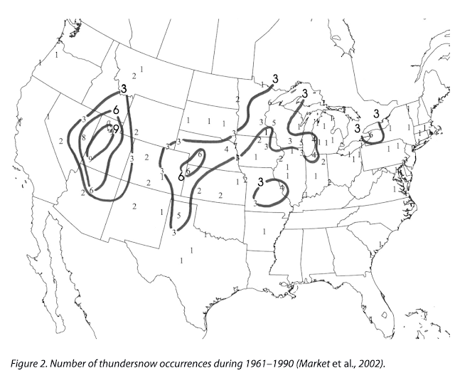 |
| Source: Schultz and Vavrek (2009)/Market et al. (2002) |
Thundersnow is basically a thunderstorm with snow falling at the surface. The key ingredients are instability, moisture, and lift. Basically, you need a strong updraft and a cloud with a mixture of ice and liquid water to promote electrification and charge separation. As noted in the Schultz and Vavrek article, collisions between graupel and other ice particles are thought to promote storm electrification and charge separation.
I'm not excited for the inevitable upcoming inversion event in Salt Lake. Models have 700mb temperatures getting up into the -2C range by the end of this week, isn't hugely impressive on its own but raises some eyebrows when you consider the deep snowpack we have right now on the valley floors.
ReplyDeleteThe one good thing I see is dewpoints/RHs are already moderately high, so within the next few days I imagine we'll probably develop some fog or low stratus that would keep us from cooling off too much at night. Can't wait for everyone to start complaining about how bad the "pollution" is when the majority of what they're looking at is fog...
Fortunately, someone has already written a recent paper updating the thundersnow climatology map using satellite data. See Figure 4: https://doi.org/10.1029/2018JD028839
ReplyDeleteNot sure how I missed that one. I even think I've seen Chuntao speak on this topic now that my memory is jogged. Thanks for sharing.
Delete