
The model forecasts for the next "sevenish" days are about as good as I've seen in a long, long time.
The downscaled NAEFS product has action starting during the day tomorrow (Thursday) and the pattern remaining active through the period we generate forecasts for, which ends at 0000 UTC 29 December (5 PM MST Tuesday 28 December).
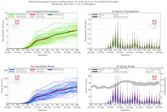
Through that time, the driest ensemble members generate almost 4 inches of water equivalent and just over 50 inches of snow. The wettest put out ridiculous numbers around 10 inches of water and 150 inches of snow.
This product has been on the wet side this year, but lets pessimistically cut these numbers in half. That gives a range for water of 2-5 inches and snow of about 25-75 inches, with ensemble means of about 3 and 50 inches. Wunderbar!
Our GFS-derived forecast for upper Little Cottonwood is generating just over 4 inches of water through 11 PM Tuesday, which converts to just over 50 inches of snow. The Thursday and early Friday part of the storm will be mild. Precipitation in the valley will be of the liquid variety and I'm concerned about negative impacts on snowpack at Mountain Dell during that period as it will probably see some rain at times. At upper elevations (e.g., Alta) the snow will be a bit on the heavy side. After Friday, temperatures fall and snow-to-liquid ratios increase, meaning drier snow.

Meteorologists can be like artists in that we fall in love with our models. However, this looks to be a very productive storm period. It will transform the ski conditions at the resorts, but also exacerbate the backcountry avalanche hazard.
Bring it on!
ReplyDeleteMtn Dell will be good: The Mtn Dell crew already has a captured a widespread consolidated base which should, other than a few spots, survive some early rain and provide a good surface for the hopefully 7 or so inches after the rains roll out.
ReplyDelete