Showing posts with label Mountains. Show all posts

Friday, June 19, 2026

The Großglockner Hochalpenstraße

There are many great drives in the world, including some in Utah.  One that is surely on the list is the Großglockner Hochalpenstraße (Grossglockner High Alpine Road) in the Hohe Tauern National Park of Austria.  

The Grossglockner High Alpine Road is the highest surfaced road in Austria, reaching 2504 meters (8215 feet).  There is also a cobblestone spur road that will take you to the 2572 meter summit of the Edelweissspitze. We drove the road from north to south and then back in the same day.  It's not peak season here yet, so parking and pulloffs were not busy, but still the road was full of tourists (like us), bicycles, motorcycles, Porsches, and various "supercars."

The Grossglockner High Alpine Road was built in the 1930s and reminded me of the Going to the Sun Road in Glacier National Park and other National Park scenic roads in the US that were built in that same era.  It takes a sinuous route to and from the high altitudes.  

The Grossglockner High Alpine Road from Edelweißspitze

Our route took us first up the Fuscher Valley, a deep U-shaped valley with as much as 2400 meters of relief to the highest peaks.  Cascades and waterfalls tumble through green meadows.  It's very spectacular.


The higher elevations were more glaciated even only a few years ago.  Interpretive stops discussed ice falls from calving glaciers that no longer extend from flatter areas to the edge of steep terrain.  Austrian glaciers are not just retreating but disintegrating.  

After crossing two mountain passes, we began to descend into the Mölltal (Möll Valley).


Eventually we took a side road 8 km to the Kaiser Franz Josef viewpoint of the Grossglockner, Austria's highest peak (3798 meters).  Beneath the Grossglockner is the Sandersee, a glacier lake that began to form in the 1950s due to the melting of the Pasterze glacier.  Currently, the Pasterze glacier is Austria's largest glacier, but that may change soon.  There is a narrow neck, known as the Hufeisenbruch, that connects the upper and lower Pasterze (red circle).  That neck is narrowing and the Pasterze expected to split in two in the near future.  When that happens, it will be classified as two separate glaciers. 


The Kaiser Franz Josef viewpoint is beautiful but about as industrialized as you can imagine.  It has a massive parking garage and even a long tunnel that will take you through the mountain if you want to hike to the upper Pasterze.


Fortunately it wasn't very busy while we were there.  

Near the southern end of the road is the mountain village of Heiligenblut.  If you go to the right place, you can find a quintessential view of their church and the Grossglockner.  


The Grossglockner High Alpine Road is a toll road and for a vehicle it is 46 euro for day pass.  It's a touch cheaper for a motorcycle and completely free for a bicycle, although accident insurance is recommended and costs 4 euro (mountain rescue in Austria can be costly).  

One tip is to stay at a hotel or guesthouse that is a partner with the National Park Summer Card.  THe summer card gives you a free day of access to the Grossglockner High Alpine Road and you can get free access to one of the sixty attractions included in it each day.  For example, one day we visited the Krimml Waterfalls and other day we used the Rudolfhutte cable cars for hiking.  Such cards are common in the Alps and worth looking into.  For this trip, we rented a car (it was my first time driving in over 3 months!), but for others, such visitor cards often provide free transit access.  

Sunday, September 28, 2025

Mountain Update

I've been AWOL from the blog for a bit as I took a couple of weeks off from e-mail, social media, and tech as much as possible to recharge my mental batteries.  I need to do it more often.  Near as I can tell, humans are supposed to be swamping stories around a campfire, not suffering from all-day barrages of alerts and click bait.  

A few days ago we were in Mt. Rainier National Park, which is one of the gems of the National Park system. Skies were a bit hazy with smoke from nearby fires, but views were still outstanding.  The photo below is from the Mount Fremont Trail near Sunrise.  I love this part of the park, especially in late September when crowds are down and the upper-elevations are snow free and ideal for alpine hiking.  

I've hiked most of the trails in this part of the park, including an ascent of "the mountain" from the White River Ranger Station via Camp Schurman and the Emmons Glacier.  That was more than 30 years ago.  I believe we did 10,000 feet of climbing and descending in less than 24 hours with no altitude acclimatization.  The joys of youth!

After returning to the Wasatch, it was nice to see the fall colors near peak this morning.  

Canyon traffic was also near peak and I suspect the daily traffic counts this weekend must have greatly exceeded those from peak winter days.  News media reported that the Alpine Loop Highway closed on Saturday due to heavy traffic.  

Hoping to return to more regular posting soon.

Wednesday, September 17, 2025

Snowpack Update

I woke up this morning with a nip in the air and noticed that Alta Base, Alta-Collins, and Hidden Peak all had temps in the 30s.  It seemed like a good day to go for a hike and check out the end of season snowpack.

I finished my hike at the top of the Snowbird Tram.  From that vantage point, no snow appears to remain on the American Fork Twin.  All I could see was a very small patch of dirty snow in upper Hogum that can't be discerned in the photo below.  

I couldn't see into upper White Pine and a few other spots that might hold snow.  I suspect that with only a couple of very localized patches, it's pretty much a do over in the central Wasatch.  

Earlier I bagged Sugarloaf Peak and Mt. Baldy.  From the latter I could see some lingering snow in the Timpanogos Glacier cirque.  You'll have to squint to see it!


Today would have been my Dad's 83rd birthday.  I was glad to get out and enjoy some of the scenery that he loved to see when he visited.  My mom is a huge Robert Redford fan, so we often went to Sundance for a scenic chairlift ride and the hope of glimpsing the movie icon (which never happened), but the views of Mt. Timpanogos are a pretty good consolation.  Sadly Bob is now gone too.  Long live the beauty of Provo Canyon, Sundance, and Mt. Timpanogos.  

Sunday, June 2, 2024

Back from Scotland

It's been a long blog break while my wife and I were visiting Scotland.  A visit to the northernmost part of the United Kingdom might not be on your bucket list, but it didn't disappoint.  The Scottish Highlands contain some ancient mountains, lots of lakes (lochs), and spectacular coastlines.  I'll give a quick summary.

We started in Edinburgh, which was quintessentially Scottish with weathered buildings overlooked by Edinburgh Castle.  


Edinburgh is technically in the lowlands, but you can =get in a short climb above the city by ascending Arthur's Seat in Holyrood Park.  


Leaving Edinburgh, we got a glimpse of the lower slopes of the "original" Ben Lomond, which rises above Loch Lomond. 


Mother Nature blessed us with clear skies on the day we had booked an excursion out to Staffa Island.  We enjoyed the coastal scenery and puffins.


One of the reasons I like to go to places like Scotland is cool weather, clouds, and rain.  We get enough of the sun in Utah.  I like to travel to places where the rain gear and winter hats come out for a day or two.  Lightweight winter gloves were even on for a while on this hike. 


Call them hills if you want, but the ancient, wind-swept, treeless landscapes of the Scottish Highlands make for some spectacular scenery, even in the rain.  And the single-track, two-way roads can be a lot of fun to drive. 


Scotland has a rich climbing history.  Below is a monument to Norman Collie and John Mackenzie, pioneering mountain guides on the Isle of Skye and beyond.  


We paid a visit to Cairngorm Mountain Resort, one of Scotland's ski areas.  Seemed hard core not because of steepness, but exposure to the elements.  This is wind swept terrain.  Respect for the dedication.    


We did a hike up to one of the coires (glacial cirques) near the ski area.  Beautiful spot.  


If you are wondering, haggis was eaten and scotch was drunk.  

Monday, July 3, 2023

Blogging Returns

After a one month hiatus, I returned to Utah over the weekend and am back in the office this morning.

The past month I was in Europe for a trip that was about 1/3 work and 2/3 vacation, although even the former was enjoyable and involved spending a week in St. Gallen, Switzerland for the International Conference on Alpine Meteorology and a couple of days at the University of Innsbruck.  

Our trip began in Normandy, France, which was much prettier than expected, especially along the English Channel.


A popular spot to visit is Mont Saint Michel, which you may recognize from the picture below.  Places like this are overwhelmed with tourists, so we tend to visit early or late in the day.  This summer marks 1,000 years since construction at this site began.  1,000 years!  Despite the crowds, I always find touring through places like this very interesting.  


We also spent an afternoon in Saint Malo just a bit down the road.  The so-called "walled city" was known for it's pirates.  It was heavily bombed by the Allies during World War II and 80% destroyed.  It has been rebuilt in spectacular fashion.  


We then abandoned the automobile and raced across France on the TGV (Train à Grand Vitesse) at speeds reaching almost 200 miles per hour.  We covered much of the distance from Paris to Chamonix in about 2 hours before switching to a slower regional train.   It's a shame that the US can't seem to figure out how to make such a system work.  

This was our first trip to Chamonix.  I debated for a while whether to cancel this part of the trip and opt for something else as the weather forecast looked quite unsettled.  Indeed, we dealt with a decent amount of clouds, but there were enough breaks to make the trip enjoyable.  

No visit to Chamonix is complete without a trip up the Aiguille du Midi.  This peak on the side of Mt. Blanc is 12,605 ft high and is served by a series of two cable cars that rise 9,209 feet above Chamonix.  


The weather wasn't ideal, but Mont Blanc was visible, as well as the upper Mer de Glace, an enormous glacier that is skied during the Vallée Blanche ski descent.  


It's nearly impossible to have any sense of scale in Chamonix based strictly on your eyes.  Everywhere you look there's thousands of feet of relief (in some cases more than 10,000 feet of relief) that looks like a short ski tour.  

It's a good thing we were hiking. One of the things I love about the Alps is the ability to use public transit and cable cars to do point-to-point hikes.  One day we hiked the Grand Balcon Sud from the top of the Flégere cable car above Les Praz to the Plan Praz cable car above Chamonix.  Much of the hike, we were mesmerized by the Mont Blanc massif.  


We also visited Montenvers which is accessed by train and where you can hike down to the lower Mer de Glace.  Here, the tremendous glacier change over recent decades is very apparent.  


Some people online commented that in part the glacier retreat is due to the emergence from the Little Ice Age.  If one is looking at longer time periods, that's true, but since 1990, a majority of the glacier loss, which is accelerating, is due to human factors.  

We then skipped over to Zermatt, which was another first for us.  This may be sacrilege to say, but I confess that I wasn't a fan of Zermatt the village.  However, the Matterhorn is definitely mesmerizing and I couldn't take my eyes off it either in town or when we were hiking.  I could watch the development and evolution of the famed banner cloud, which forms on the downstream or lee side, all day.  


The trip up the railroad to Gornergrat is expensive, but the views of the Monte Rosa massif are truly spectacular.  


You can use the railroad to enable some great hiking above 2000 meters with incredible views in all directions (this can also save some Swiss Francs).  


We then moved to St. Gallen for my meeting, but arrived a day early to hike in the Appenzeller Alps, which like on the northern Alpine Rim.  A train and bus ride take you to EbenAlp where you can opt for valley and ridge hikes, including along the Alpstein Massif pictured below.  


The highest peak of the Alpstein Massif is Säntis, which is just center right on the horizon in the picture above.  Although "only" about 2500 meters high, Säntis has more than 2000 meters of topographic prominence, which is #13 in the Alps.  It is a famous location meteorologically as a weather station began operating there in 1882, it is a magnet for lightning, and is known for heavy snowfall.  I don't know how they measure at the summit (we visited as part of my conference), but the 1991–2020 average snowfall was 1003 cm (395 inches).  

Our trip concluded in Innsbruck.  The Austrian Alps remain my favorite. I love the hiking and the culture.  We did three great hikes.  The first was on the ridge immediately south of Innsbruck and the Inn Valley from the Patscherkofel cable car to the summit of Glungezer.  


The second, was along the Goetheweg on the Nordkette ridge south of Innsbruck.  


I think the Goetheweg hike is my all-time favorite.  We've done it three times and I would do it tomorrow if I could. 

Finally, we spent a day hiking on the Rofan Massif east of Innsbruck, summiting the Rofanspitze (pictured below) and the Spieljoch.  


This was a dream trip for us and we recognize how lucky we are.  We were in Normandy on June 6, the anniversary of D-Day, and visited the landing beaches and monuments.  On D-Day, Company of the 116th regiment was the first ashore at Omaha Beach and took 90% casualties.  The US spearheaded invasions at Omaha and Utah beach that day and the Normandy American Cemetery is the resting place for more than 9,000 heroes who gave their lives to defeat Nazism and Fascism.  Others rest closer to home in the United States.


The British and Canadian militaries invaded three other beaches, with contributions for the D-Day landings from 18 other countries.  We can all be grateful that Hitler's "Atlantic Wall" fell that day, marking the beginning of the end of an awful period in human history that resulted in tens of millions of military and civilian casualties.  Thanks to the sacrifices of the Greatest Generation we enjoy our freedom today. 

Sunday, October 16, 2022

Land of the Impossible

For the first time in many years, my teaching schedule allowed me to travel over a two-week period in early October, including last week's spring break.  Andrea and I had not returned to Innsbruck since we lived there during my sabbatical in 2019 and we wanted to see friends there.  We also thought it might be a good time of year to visit the Jungfrau of Switzerland, which is the focus of this post.

I've wanted to visit the Jungfrau since reading Jon Krakauer's Eiger Dreams.  Watching the Lauberhorn Downhill and its incredible mountain backdrops, also increased the stoke. 

The Jungfrau region lies south of Interlaken, Switzerland and includes the Junfrau Massif (consisting of the Eiger, Mönch, and Jungfrau), the Lauterbrunnen Valley, the Grindelwald Valley, and the villages of Grindelwald, Wengen, Lauterbrunnen, and Mürren amongst many other peaks, valleys, and villages.  I found it to be the Land of the Impossible due to the impossible relief, impossible mountain transportation system, impossible cog railroads, impossible cable cars, impossible beauty, and impossible costs.  

We spent five days and four nights touring the region, using Mürren as our base.  Mürren sits at 1638 meters on a precarious ledge above the Lauterbrunnen Valley.  If you were a community in the middle ages, you could pick a better "natural fortress" to avoid marauders.  

Mürren (center) from the Birg cablecar station with the Wetterhorn (far left), Eiger, Mönch, and Jungfrau behind.  

Mürren (top of cliff near center) from Klein Scheidegg.

Even today, you can't drive a car to Mürren.  I think there may be a windy and steep access road to get equipment there, but for the public you have to either hike, take the bus from Lauterbrunnen to Stechelberg and then two trams, or the tram from Lauterbrunnen to Grütschalp and then a train from Grütschalp to Mürren.  In the case of the former, two trams are used to avoid the steep cliff below Mürren, but they are being replaced by a new cable car that ascends the cliff directly and will be the steepest in the world.  Below is the "materialsbahn" they are currently using along the route to ferry construction materials.  I measured the mean cable slope angle at 55˚. 


One of the touristy and very expensive things to do in the Jungfrau is to take the cog railway to the Jungfraujoch, a prominent col between the Mönch and the Jungfrau that was carved in through the Eiger and Mönch and sits at 3463 meters.  In the col is a rocky prominence known as the Sphynx, pictured near center below.

Junfraujoch and the Sphynx between the Mönch and Jungfrau at dawn.

On the Sphynx sits the Sphynx Observatory, which has been a critical meteorological and astronomical observatory and still collects observations today.  

Sphynx Observatory

Of course, this being the Alps, the Sphynx also includes restaurants, shops, and the like.  We stocked up on calories for future hikes.

No chocolate was harmed in the taking of this photo. 

The Jungfraujoch overlooks the upper reaches of the Aletsch Glacier, the largest in the Alps.  

Aletsch Glacier from Jungfraujoch

The mountain transportation system in the Jungfrau might be the most comprehensive in world.  One day we decided to do a hike in First, above Grindelwald.  From Mürren we first took the mountain railway from Mürren to Grütschalp, then a cablecar from Grütschalp to Lauterbrunnen.  In Lauterbrunnen, we got on the cog railroad to Zweilütschinen where we switched to another cog railway that took us to Grindelwald.  After a 10 minute walk we rode the gondola to First, where we did some incredible Alpine hiking.

Looking south from above First

On the return, we descended the First gondola, walked through Grindelwald to the Grindewald terminal, and rode another gondola to Männlichen.  In Männlichen you can look back to Grindelwald and the north face of the Eiger.  

Grindelwald and the north face of the Eiger (in shade) from Männlichen. 

You can also look down to Wengen and the Lauterbrunnen Valley.  

Wengen and the Lauterbrunnen Valley from Männlichen.

However, we were only half way home.  We then descended the cable car to Wengen, transferred to a cog railway that took us to Lauterbrunnen, then back up the cable car to Grütschalp, and finally the mountain railway back to Mürren.  That's 5 train segments and 6 cable car rides for the day.  

From the Grütschalp cable car that afternoon, I took the photo below showing the middle-earth-like quality of the Lauterbrunnen Valley with Jungfrau (4158 m) towering over Lauterbrunnen (802 m), the Lauterbrunnen Valley, and the Staubbach Waterfall.  


This place is real, right?  Amazing stuff.

However, the Jungfrau is a place of contradiction and given that comments are due for the Little Cottonwood Gondola tomorrow, its worth highlighting some of these contradictions.  Yes, the Jungfrau has an incredible mountain transport system, but it also has intensive development in natural areas and is incredibly expensive.  For example, Klein Scheidegg, the Alpine pass between the Lauterbrunnen and Grindelwald Valleys, includes hotels, restaurants, a train station, and three railways. 


In Grindelwald, the Grindelwald Terminal is a massive building that includes a parking garage, rail station, two cable-car stations, and a small shopping mall.  I didn't bother taking a picture.  

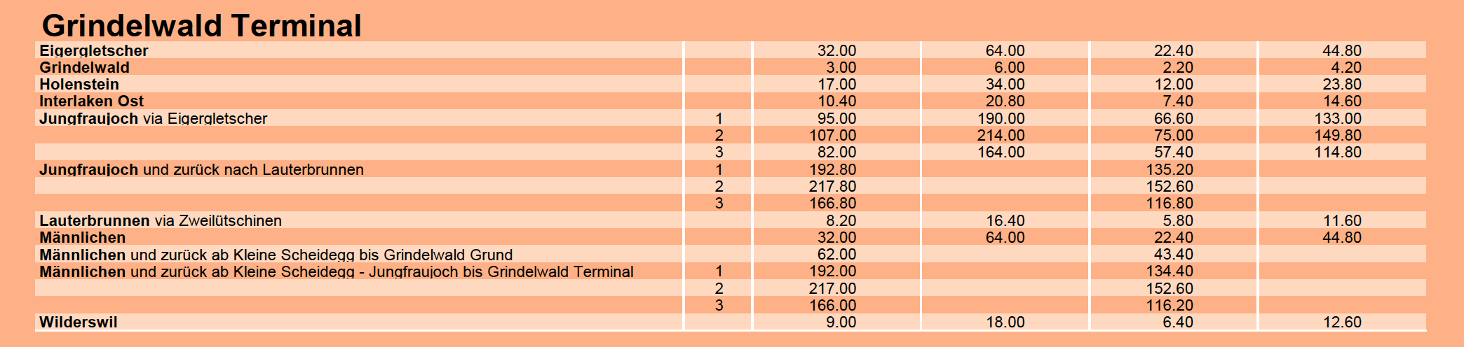
Below are some sample fares in Swiss francs, which at current exchange rates roughly equate 1 to 1 with the US dollar.  The trip to Eigengletscher from Grindelwald Terminal on the "3S" Eiger Express, a tri-cable gondola similar to the one proposed for Little Cottonwood, 64 Swiss francs/USD. 


The Eiger Express is about 6.5 km (4 miles) long and the ride takes about 15 minutes.  This is about half the length of the Little Cottonwood Gondola.  

You can get discounts.  We elected to buy a Swiss Half-Fare card for 120 Swiss francs, which gave us 50% off on all our our rail and cablecar travels in Switzerland.  Still, with that discount, the Eiger Express is 32 Swiss francs/USD round trip.  Alternatively, you can by a Jungfrau pass to cover much of the transport (190 for 3 days, 215 for 4, although the Jungfraujoch cog railway is additional).  

Switzerland is expensive and our days in the Jungfrau, while incredible, were surely the most expensive vacation days of our lives.  It's clearly an area for the well heeled, and I don't mean people who can hike a long ways.  

It makes me wonder about the future of the Wasatch.  If the Little Cottonwood Gondola is built, how much will it cost for individual users?  How accessible will the central Wasatch be for the broader community, not just those with financial means?