Saturday, November 27, 2021

Haves and Have Nots

The gap between the snowpack haves and have nots in the Wasatch Range right now is staggering.  There's essentially little to no snow below 7500 feet and on south aspects.  On the other hand, there is a very stout 30+ inches on north aspects at and above 9500 feet in upper Little Cottonwood Canyon.  

Collins Gulch is the one percenter of the Wasatch by snow depth.  Alta-Collins has 31" on the snow stake.  On the other hand, look across the canyon and there's little to no snow left on the south facing slopes.  


Today Alta had Collins, Sugarloaf, Sunnyside, and Supreme spinning.  Cover on the main runs is pretty good.  Off piste coverage is pretty good in some areas too (although not so good in others).  Contrast this with other Utah ski resorts that are either closed or spinning a couple of short lifts.  

I see this season as a harbinger of things to come, with the gap between the snow haves and have nots growing during the 21st century as the climate continues to warm.  If you think the upper elevations of Little Cottonwood are hallowed ground now, wait until 2050 or 2070.

Friday, November 26, 2021

Will It Ever Snow Again?

No.  Last night's 0600 UTC GFS below.  Nothing.  Granted its one model and only for 7 days into the future, but if you extrapolate this out it won't ever snow again.  

Did I mention it's also warm?  

Wednesday, November 24, 2021

Taking Requests


If all goes well, I will be working this spring on a new edition of my book Secrets of the Greatest Snow on Earth.  Thus, I'm taking requests.  Let me know of any topics you'd like to see covered better or in greater depth.  

Tuesday, November 23, 2021

The Cross-Valley Contrast in Air Quality

Yesterday morning we discussed how a meteorological inversion had developed, but that the air quality was still good to moderate.  There just wasn't time yet for emissions to accumulate within the valley cold pool.

However, by late afternoon, it was clear that the air quality was declining, with smog evident over the Salt Lake Valley as the sun set over the Oquirrhs.  


This morning, one can still see a veil of smog over the valley.  It seems to be particularly bad over the western valley.  


The way that sunlight is scattered by pollution is such that one needs to be cautious assuming that what looks more polluted is more polluted, but that's not the case this morning.  Purple air observations confirm what one infers from the photo above with a clear increase in PM2.5 concentrations across the Salt Lake Valley.  On the east bench, PM2.5 concentrations are at good to moderate levels, whereas in the West Valley, they are higher and in some cases in the unhealthy for sensitive groups category.  


The purple air sensors sometimes read high that appears to be the case today. However, if we look at observations from PM2.5 sensors operated by the Department of Atmospheric Sciences on TRAX trains we still see the increase in PM2.5 concentrations across the valley.  Values are not as high as suggested by PurpleAir, but still max out very near the threshold for unhealthy for sensitive groups.  

Source: https://utahaq.chpc.utah.edu/. 

The situation above is not uncommon.  The reality is that the air quality in the West Valley is often worse than on the east bench.  This is a consequence of several factors including spatial patterns of emissions, elevation, and circulations such as cleaner canyon outflow jets in the morning on the east side.  

The good news is that we have a front coming in tonight, so this episode should be short lived.  The bad news is that ridging will predominate through at least the middle of next week.  Lack of valley snow cover will help, but expect to see declining air quality after Thanksgiving.  

Monday, November 22, 2021

Inversion Season Is Here

Don't be fooled by the lack of snow and sunny skies.  Inversion season is here and this morning a fairly strong one exists over the Salt Lake Valley.

The term inversion has different meanings for meteorologists and the public.  Meteorologists consider an inversion to be a situation in which instead of temperature decreasing with height, it increases.  We have such an inversion in place this morning.  As shown in the sounding below, the temperature at the surface this morning at the Salt Lake City airport was -0.30˚C, but as you went up, it climbed to 4.2˚C at 767 mb (about 8000 feet).  That is a meteorological inversion.  

Source: NOAA/NWS/SPC

To the public, an inversion is a situation with poor air quality, typically occurring the winter.  These events often feature high PM2.5 concentrations and in some cases fog.  

However, meteorological inversions and what the public calls an inversion are equivalent.  It is possible to have a meteorological inversion, but good air quality, and it is possible to have a poor air pollution episode without a meteorological inversion.  

For example, the meteorological inversion present this morning formed late yesterday and last night as high pressure built over the area and temperatures aloft increased.  As a result, there hasn't been sufficient time to build up high PM2.5 concentrations and cause an air quality event with PM2.5 levels at unhealthy for sensitive groups.  Although a meteorological inversion is present, the air quality is good to moderate.  A look at purple air data shows PM2.5 concentrations generally less than 5 at many east bench locations and 12-20, with a few outliers, along the valley floor.  


On the other hand, some poor air quality events are not bonafide meteorological inversions.  During winter, the air in the Salt Lake Valley can become highly stagnated even if a true meteorological inversion is not present.  This is because the stability of the air depends not only on temperature, but also pressure.  Situations in which the temperature does not increase with height, but instead decreases very slowly with height, are still very stable, and prone to poor air quality.

Remember that the air quality isn't bad because of the "inversion."  The inversion is a naturally occurring phenomenon.  The air quality is bad because of emissions related to fossil fuel combustion and other activities occurring in the Salt Lake Valley (click here for more information). 

Sunday, November 21, 2021

Closing Day

 Closing day of touring season at Alta was a beautiful one with a low-angle sun lighting the scene.


Conditions offered up a mixture of cream on crud, gunpowder, and groomers as the resort prepares to open for lift-served skiing on Wednesday.  Natural cover in upper Collins Gulch is quite good for mid-to-late November.  


It was a pretty interesting day meteorologically if you're into the snow energy balance.  Check out the observations from the top of Mt. Baldy.  Temperatures climbed during the day, reaching almost 31˚F by 2 PM, but dewpoints were quite low.  


As a result, the area in the shade of Mt. Baldy was a pretty good icebox.  With clear skies and very very low humidities, conditions were ideal for radiative cooling due to the lack of incoming short-wave and long-wave radiation, as well as sublimational cooling.  

Alta should have good lift-served conditions for opening day on Wednesday.  If you are hoping to see more natural snow, however, pickings look slim for the next week.  Give thanks for upper-elevation north-facing terrain and hope that Mother Nature changes the pattern soon.  

Thursday, November 18, 2021

Weekend Snow Prospects

The weekend approaches with guns blazing early this Thursday morning.  Below is a shot from Deer Valley illustrating the lack of natural snow cover at lower elevations and the ongoing artificial snowmaking efforts.

Temperatures, however, climbed overnight at upper elevations and today will not be as favorable as yesterday for snowmaking once the cold pools that remain at lower elevations burn off. Observations within 1 hour of 14:51 UTC (0751 MST) show temperatures near or above 32˚F in mid elevations, but still well below freezing at some lower elevation sites.  For example, it was 15˚F along SR-224 near the base of Park City Mountain Resort, but 31˚F at the top of Jupiter.  In Big Cottonwood Canyon it was 16˚F at the Cardiff Fork parking lot, but 33˚F on Reynolds Peak. 

It will help that the airmass is currently extremely dry.  The dewpoint on Mt. Baldy is about -30˚F, and this results in the wet-bulb temperature being much lower than the actual temperature.  The wet bulb temperature is the temperature you would have if you evaporated water into the air until it reached saturation.  It is a better indicator of snowmaking potential and quality than the air temperature.  It is possible to make snow at temperatures near or above 32˚F if the wet bulb temperature is below about 27˚F.  However, the temperature, humidity, and wet-bulb temperature will be rising today and this will make snowmaking difficult.  

Prospects for natural snow aren't zero, but a major storm for this weekend is unlikely.  Instead, it looks like we'll have a week system coming through Friday night and Saturday morning.  The time-height section for Salt Lake City summarizes the situation.  High humidity at upper levels will bring some high clouds at times today and tonight.  That upper-level moisture may bring a few dribs of precipitation tomorrow at upper elevations, but accumulations should be close to nil.  A weak trough and front move in late Friday night and early Saturday, bringing some periods of snow before the next ridge builds in.  


From about noon Friday to 11 AM Saturday, the GFS generates 0.28" of water and 3.5" of snow for Alta-Collins.  This is just above the middle of the distribution for the downscaled SREF ensemble, which has a mean water equivalent of about 0.22" of water equivalent and 3" of snow.  Some members produce scant amounts.  Four out of the 25 members produce > 5".   


Looks like a dust on crust event to me, with 2-4" most likely at Alta-Collins and perhaps a 20% chance that this is an overproducer that might do 5-8".  Could start as rain at mid elevations, but for the most part we should see snow at or above the base of Snowbird.  

If you are planning on touring at Alta, please see the information below.  Last day for uphill is Sunday.  

Monday, November 15, 2021

When Will Winter Begin?

The original title for this post was "when will winter return," but it's only November 15th, so it hasn't really started yet.  Better to say "when will winter begin." 

This has been one of the more bizarre starts to a ski season that I can remember. Alta is reporting 81" of snow so far this season, based largely or entirely on observations taken at the Alta-Collins site at 9662 feet.  The Alta Coop site in town has reported 58.7".  Long-term records for that site indicate an average of 30.6 inches of snow in October and 62.8 inches of snow in November, so we'll round it to an average of about 45" through November 15.  Clearly we are running above average, which sounds good.  

Indeed, there is a very solid 31" of snow at Alta-Collins and we are running above average for snowpack water equivalent at the Snowbird SNOTEL site at 9177 ft.  If you are above 9000 feet on north aspects, there's a pretty healthy snowpack in the central Wasatch for mid November. 

Elsewhere, not so.  Below is a photo taken yesterday at Alta from "West Buffler."  Looks like a good November ski day.  Decent cover.  Tracks everywhere.  Lot 2/3 full.  However, you can see how thin the snow is across the highway on the south aspects. 


Drive a bit down the highway to the bottom of Big Emma at Snowbird and snow is scant.  By the time you get to the White Pine lot is is nearly non-existent.

We've had above average snowfall so far, but a significant fraction of that snow came in October.  The Alta Coop site had 48.5 inches in October and only 10 inches so far in November.  It would have been better if it were the other way around.  Early snow is vulnerable snow, and we've lost a lot of it except on high north aspects.

Additionally, it has been warm.  At the Salt Lake City airport, where records go back to 1874, the average temperature during the first two weeks of November was 50.4˚F, the 7th highest on record.  

The news for today isn't much better.  Forecast 700-mb (10,000 ft) free atmosphere temperatures for this afternoon are around 6˚C, typical of late September.  More loss of south facing and mid elevation snowpack where it exists can be expected.

A weak front is expected tomorrow, which will drop temperatures for a bit.  I suspect you'll see snow guns going at Alta Tuesday night and into Wednesday.  There's a weak system again for Friday, but overall the pattern is one that favors above average temperatures, below average precipitation, and limited periods with good snowmaking conditions. 

October came in like a lion, but November may be a lamb.  At least there's snow on high north.

Friday, November 12, 2021

New GFS Derived Guidance for Upper Little Cottonwood

I've been posting some new GFS-derived forecast guidance products for upper Little Cottonwood Canyon in posts over the past few weeks and just added a link for them to weather.utah.edu.  You can find them in the top navigation bar by clicking on LCC GUIDANCE (NEW).  The old guidance is still available there too, but eventually I'll get rid of it.  

The old guidance includes tabular data from the 12-km NAM and the 3-km NAM, but these modeling systems are aging, so I'm not spending any more time on them.  I'm going to start deemphasizing them for the most part.  weather.utah.edu is also horribly old and ancient, but I simply don't have the time to rewrite everything, so we'll keep limping along.  

The new LCC Guidance page is pretty basic and includes forecast meteograms of several variables at the top and a window with scrollable tabular output.  Yeah, it's not mobile friendly, but you get what you pay for here at the Wasatch Weather Weenies :-).  

Here's a summary of the products available and how they are produced:

  • Mt. Baldy Temperature and Dewpoint: Based on a straightforward machine learning approach based on two cool seasons (October to April) of training with past GFS forecasts (multiple levels and variables) and Mt. Baldy observations.  Given that temperature and dewpoint vary diurnally, we have unique equations for each model initialization time and forecast hour, the latter at 3-h intervals.  For hourly forecasts, we use the GFS forecast valid at that time, but the equation for the nearest 3-h forecast hour.
  • Mt. Baldy Wind Speed, Wind Gust, and Direction: Same as above, but for wind.  
  • Alta-Collins Snow Ratio: This one is more difficult because a two year record doesn't have a lot of snowfall events, even at Alta.  Thus, we train over a longer period of time not to GFS forecasts, but to atmospheric analyses and then apply to the GFS. 
  • Alta-Collins 1H/3H/Accumulated Precipitation (a.k.a. QPF): Comes directly from the nearest GFS grid point to Alta.  No downscaling is applied.  I've elected not to apply downscaling because the GFS tends to be a fairly wet model despite not fully resolving the terrain.  So far this year, for larger storms, it has held up pretty well.
  • Alta-Collins 1H/3H/Accumulated Snow: Based on hourly or 3 hourly totals multiplied by the snow ratio at similar intervals.  
  • Wet-bulb zero level: The wet-bulb temperature is the temperature the air would have if it were cooled through evaporation to saturation (i.e., 100% relative humidity).  Typically the snow level is a bit below this level.  We calculate this level based on temperature and humidity at the GFS gridpoint nearest to Salt Lake City.  The reason for this if if we use the gridpoint nearest to Alta, we can't determine the wet bulb zero level when it is below about 8000 feet.  Thus, we use an upstream profile.  
These techniques produce better average errors than using the GFS directly for temperature, dewpoint, and wind on Mt. Baldy.  The snow-to-liquid ratio also produces better average errors than any other product we've compared to, including that used for the old Little Cottonwood product.  However, no forecast is perfect, and here are a few biases I've either noticed or I think may be evident moving forward:
  • Afternoon temperatures may be too low in the shoulder seasons (October, March, April)
  • Wind speeds and gusts will be too low during high wind event periods (e.g., gusts > 80 mph) and forecasts at longer lead times will not stray too far from mean values.  There are ways around the latter, but the reality is that if you compare GFS wind speed forecasts for Mt. Baldy to observations at 168 hours it looks like buckshot.  You simply don't have a reliable forecast if you use a single model.  The best path forward is to use an ensemble, but we haven't had time to deal with this.  
  • You're not going to see many snow ratios < 7:1 (unless Collins is below the wet-bulb zero) or > 20:1.  This is a tradeoff for forecast reliability.  If we use a technique that will go for big SLR, like 30:1, there's going to be a lot of false alarms.
I hope you find this project useful.  For the latest, click here.  

Special thanks to past and current Steenburgh group members for their contributions to this effort.  

Thursday, November 11, 2021

Today's Rime Event

 The models have advertised a possible riming event today and tonight in the upper elevations of the central Wasatch and it seems to be setting up as advertised.

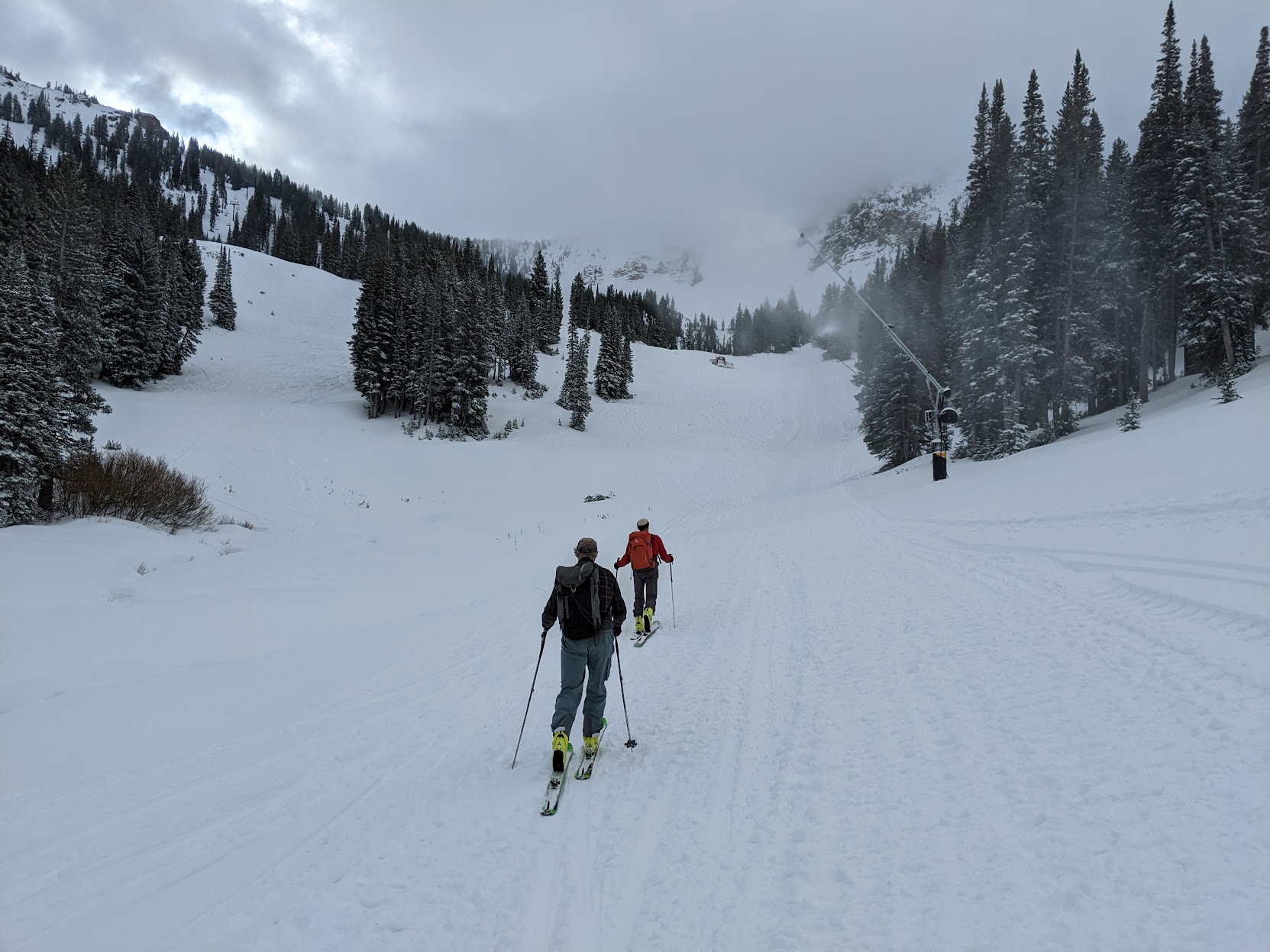
As illustrated by the photo below, taken about 8:15 AM looking south from my office on the University of Utah campus, shallow altostratus clouds are now impinging on the highest peaks of the central Wasatch.

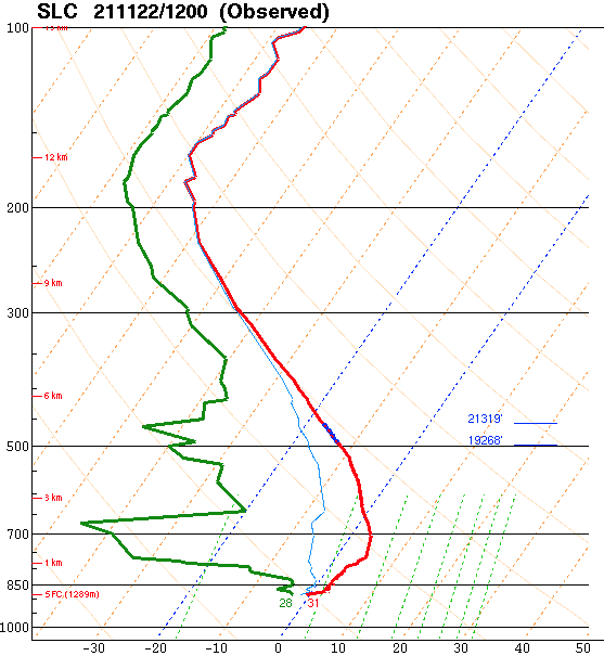
The GFS forecast sounding valid 2100 UTC (1400 MST) this afternoon suggests that by this afternoon, the altostratus layer will extend from about 750 mb (8000 ft) to 650 mb (11,775 ft), enveloping much of the upper elevations of the central Wasatch.  


Cloud base temperature will be 0˚C and cloud top temperature about -7˚C, so this cloud will largely be "subfreezing."  

However, water droplets in clouds do not necessarily freeze if the temperature is below 0˚C.  To freeze, water needs an ice nucleating particle to serve as the nucleus for ice crystal formation.  These particles are typically called ice nuclei or IN for short.

The number of particles that can serve as an IN varies depending on the types of particulate matter in the airmass and the temperature.  All else being equal, the lower the temperature, the more particles that can serve as IN.  

At temperatures just below 0˚C, however, there aren't typically many IN available.  As a result, clouds that don't extend to temperatures below about -10˚C tend to contain a lot of supercooled cloud droplets.  If these droplets can combine and grow into larger droplets, especially drizzle, they tend to freeze on contact with a sub-freezing surface, such as trees, the ground/snow, lift towers, buildings, etc.

In general, conditions in Utah do not favor extreme riming events like occurs in other parts of the world, especially in maritime regions like the Olympic and Cascade Mountains, southern Andes, etc. In Patagonia, spectacular rime mushrooms often form and represent a challenge and hazard for mountaineers.

Rime mushrooms on Cerro Torre (Photo: Rolando Garibotti).  Source: Whiteman and Garibotti (2013).

You can read more about them in this article by my college Dave Whiteman and mountaineer Rolando Garibotti.

It's probably a good thing we don't get such extreme riming in Utah, although even our light rime can be an issue for ski area operations, ski conditions, and future avalanche conditions.  

Although the cloud and temperature conditions today and tonight are generally favorable for rime, the severity of the event will depend to large degree on small-scale processes that are more difficult to anticipate.  In particular, with the winds, turbulence, and cloud microphysical processes favor the development of larger supercooled water droplets that rime more efficiently?  Will the clouds get just deep enough that some droplets can freeze and help reduce supercooled water concentrations?  These are questions I can't answer.  We will just have to see how things evolve today and tonight.

Wednesday, November 10, 2021

The Best Skiing Is Not Found in the Driest Snow...


So, you think you know snow?  Well, Ed LaChapelle certainly new more than you.  Probably the preeminent American avalanche researcher, Ed wasn't fooled by the marketing hype about dry snow.  There's more to skiing than the average water content of freshly fallen snow.  

Case in point: Today.  Alta-Collins measured 11" of 13% water content snow.  Average at Alta is 8.4%.  Average at the Central Sierra Snow Lab near Truckee is about 12.5%.  So basically, Sierra Cement.  However, it skied great.  Lots of graupel.  Wonderful body.  Below is a septuagenarian friend of mine getting the goods on lower West Buffler.  

Of course I have had better skiing than today, but not in 20" of 4%.  More typically when the snow is stacked right with lower density on top of higher density.  That gives you flotation and bounce and makes for the hero snow we all love.  Body is more important than bone dry.

That's enough snow snobbery for one day.  In other news, prep for the opening is now in full swing at Alta.  The cats were out and in places the guns were running this morning.  

Hoping they allow uphill for a few more days. I'm also hoping for a bit storm cycle, although that looks unlikely through at least the weekend.  Some higher elevation riming possible tonight and tomorrow, with snow in fits and starts not adding up to much.  An angry inch if we're lucky.  

Tuesday, November 9, 2021

As November as It Gets

If you are into grey, today is your day.

Morning dawned with a very November scene.  Valley smog trapped beneath and inversion with cirrostratus clouds aloft. 

Radar shows a harbinger of things to come with echoes moving into the western part of the state at 1440 UTC (0742 MST).

Its pretty dry at low levels, so I suspect that's virga or light rainfall on the desert floor, but precipitation is coming with rain developing in the Salt Lake Valley today, and snow at upper elevations.

A look at the latest (0600 UTC) GFS-derived forecast for Little Cottonwood shows not much has changed from yesterday, although it has gotten a bit wetter and snowier compared to yesterday's run discussed in the prior post.  Winds on Mt. Blady begin to shift beginning around 11 AM today, veering from southerly to westerly through evening.  Temperatures are mild this morning and sitting at 39˚F at the base of Alta, but the wet-bulb temperature is around 30˚F and the GFS wet-bulb zero level forecast for today has it around 8000 ft.  Thus, although we might see a spot or rain at 8000-9000 ft to start, snow levels should fall quickly to about 7500 ft once precipitation picks up.  For Alta-Collins, up at 9600 ft, the GFS puts out 1.33" of water and 13" of snow through 4 AM Wednesday morning, which would be a very healthy and needed snowfall with a mean water content of about 10%.  

Numbers from the Euro, as is often the case, are a bit lower and around 0.82" for Alta, which would be about 8" of snow.  Additionally, the downscaled SREF mean sits at around 0.6".  I'm inclined to stick with the 6-12" forecast for Alta Collins from yesterday, but hope the GFS verifies.  

Wednesday looks to be a break day, but Wednesday night and Thursday the GFS is advertising strong northwesterly flow with warm air advection and high crest-level relative humidities. 

Moist, unstable northwesterly flow is often good for the Cottonwoods, but this is stable northwesterly flow.  The GFS forecast sounding valid 1800 UTC (1100 MST) Thursday shows stable, saturated conditions from just below 700 mb (10,000 ft) to 600 mb (13,750 ft).  Above that, the air is subsaturated in the middle troposphere.  This would result in a stratus deck that envelops the upper elevations of the central Wasatch with cloud top temperatures at or above -10˚C.  Those are marginal temperatures for generating snowfall due to a lack of ice nuclei.  

Thus, Thursday could be a riming event for the upper elevations, with perhaps some fits and starts of snow at times.  

Monday, November 8, 2021

Tuesday Storm

We need snow.  Yes, I know I'm being greedy, but despite significant snowfall in October, conditions are deteriorating, as discussed in the previous post.  

Fortunately, it looks like we will get something tomorrow as a cold front and upper-level trough move through the area.  It's not a monster storm, but it is reasonably well put together and accompanied by Pacific moisture.  

Our GFS-derived forecast for Little Cottonwood below pretty much tells the tale.  The GFS brings the cold front in at around 11 AM tomorrow morning.  It's accompanied by an abrupt wind shift from southerly to westerly, but a more gradual decrease in crest-level temperature and wet-bulb zero levels.  Precipitation occurs mainly with and following the front over approximately a 12-hour period.  GFS water equivalent from just before 11 AM Tuesday to just after 11 PM is about an inch.  Snow to-liquid ratios will be low to start (perhaps 7:1) , but increase in time, although overall this will be a higher-density snowfall than average.  


Web-bulb zero levels are high enough that this could start out with a bit of rain at the base of Alta and Snowbird, but by and large, snow levels should be about 7500 feet early Tuesday afternoon and lower to perhaps 7000 feet or so by late Tuesday.  

The SREF ensemble mean is about 0.75" of water equivalent for Alta Collins and about 8 inches of snow.  For snowfall, about 60% of the members are between 5 and 10 inches. A few are lower than that.  A few higher.  


I'll go with 6-12" for Alta-Collins through very early Wednesday morning.  A reminder that the resorts are de facto backcountry and to respect any closures for uphill skiing.  I don't know if Alta might temporarily close the resort to uphill, so monitor their web-site and social media.  Please comment if you have any information.  

I'm not one to bet the house on these sorts of things, but the extended forecasts are not encouraging.  After this storm, there could be a period of moist, northwesterly flow. It could produce a couple of inches of wet snow, but more likely rime for the central Wasatch.  The 6-10 outlooks from the Climate Prediction Center show the dice are loaded for above average temperatures and below average precipitation.  Ditto the 8-14, although we're on the fringes of the transition zone. Below are the precip outlooks. 


On the plus side, the odds above suggest that the probabilities are "leaning below" average, so this is not a lock.  Nevertheless, I am hoping we're not looking at a couple of weeks during which Mother Nature snatches defeat from the jaws of early-season snowpack victory.  Snow on high north will remain, but elsewhere we really need more snow, not warm and dry.    

Saturday, November 6, 2021

Winter Reset

After being out of town last weekend, I was able to get out for a quick ski dawn ski tour this morning.  

I'm really not sure what to make of the past couple of weeks and current state of the snowpack. Alta is reporting 69" of snow so far this season, which is likely an upper mountain measurement taken at the Collins observing site.  The Alta COOP site in town and about 1000 feet lower has recorded 48.5 inches.

On the south aspects, most of this snow is gone.  Photo below taken this morning from the lower slopes of the "Collins glacier."  Apologies for the thumb, but it's precarious to take a photo there if you don't have crampons on.  The glacier is down to firn. 

There have also been significant loses on slopes with western exposures.  

I like to tell my students that all generalizations are wrong.  Saying the ski season is off to a good start is such a generalization.  Much depends on altitude aspect. For early November, we're off to a good start on northerly aspects above 9000 feet.  Elsewhere, it's pretty much a reset of winter, as the warm spells, sun, and rain have done their damage. Snow is either nonexistent or sparse.  It's hard to build a snowpack in those areas in October if you can't sustain the snowfall or the cold.  

Additionally, although it's been snowy, the average temperature at the Salt Lake City airport from 15 October to 5 November was 51.3˚F. In 148 years of records, that ranks as the 38th warmest.  Not exceptional, but that's close to in the top 25% warmest.  

Getting back to skiing, my early morning start reflected my need to work this weekend.  I'm in the office now trying to keep my head above water.  Perhaps things will soften this afternoon, but this morning, as I suspected would be the case, instead of chin ticklers there were bone rattlers.  My teeth still hurt.  

The contrast between above and below the angle station remains quite apparent and this reflects recent storms that have occasionally pushed the snow level to 9000ish feet.  Corkscrew, pictured below, reminded me of skiing on runs without snowmaking in upstate NY when I was a kid.  

 Loose and frozen granular, 2-6 inch base.  

Thursday, November 4, 2021

U to You Lecture

For those who didn't catch my talk Secrets of the Greatest Snow on Earth for the "U to You" lecture series, check out the recording of the live stream below.  


It's hard to give a talk online!  There's no audience feedback so you don't hear laughter (or lack thereof) or see quizzical looks on their faces to tell you to better adapt the material.  One comment on the YouTube site that says "pure blasphemy!" so I must have done something right.  

The lecture is based on my book of the same title.  If you are in the Salt Lake City area, King's English has copies available at last check (https://www.kingsenglish.com/book/9780874219500) or you could call Weller Book Works to see if they have a copy.   In Park City, Dolly's Bookstore sometimes has copies.  If not, there's Amazon (https://www.amazon.com/Secrets-Greatest-Snow-Earth-Mountains/dp/0874219507).  

Tuesday, November 2, 2021

Desert Delinquency

Sorry for the delinquency in posting, but we've been down in the Sonoran Desert visiting our daughter at Arizona State. 

Highs in Tempe were near 90˚F each day, but manageable due to the lower angle sun and the short day length.  There's lots of outdoor dining there as well, which is a bonus given the ongoing pandemic.  

We spent a day in the Superstition Mountains east of Tempe.  This was my first trip to the area since I was 16.  It's beautiful country.  

Although I've been to Tempe many times, we made my first visit to the Desert Botanical Garden, which was simply spectacular even if most of the plants were out of bloom.  It's definitely worth a couple of hours of time to meander the walkways and check out the desert plants.

We are in the process of designing a new building for the University of Utah that would house the Departments of Physics and Atmospheric Sciences.  I'm big on secure bike storage, which is sorely lacking on campus.  I liked these key-card access parking structures that they had on campus that require card access and then have lockable racks inside.  


We simply can't keep building parking garages on campus.  Traffic to and from campus just keeps getting worse.  E-bikes and secure bike storage need to be given greater priority.