Sunday, May 31, 2020

Incredible Late May Warmth in 2003 and 2020

The numbers yesterday from the Salt Lake City airport were absolutely astounding.  With a maximum temperature of 98˚F and minimum of 76˚F, the average temperature was 87˚F, the highest ever observed in May at the airport. 

The graph below shows the highest daily average temperature observed each May in Salt Lake City based on downtown-area observations prior to 1928 and airport observations thereafter.  There are two clear outliers in this record, 2003 and 2020.  They are only Mays in the instrumented record with at least one day with an average temperature above even 80˚F. 

Source: NOAA Regional Climate Centers
Late May of 2003 was blisteringly hot on the 28th, 29th, and 30th with maximum temperatures of 99˚F, 99˚F, and 97˚F, respectively.  Minimums were 62˚F, 71˚F, and 73˚F, respectively, yielding averages of 80.5˚F, 85˚F, and 85˚F, respectively.

Late May of 2020 was blisteringly hot on the 29th and 30th with highs of 96˚F and 98˚F, but minima of 67˚F and 76˚F yielding averages of 81.5˚F and 87˚F. 

Weatherwise, yesterday was also remarkable in that it featured showers and thunderstorms that produced strong surface winds as precipitation cooled the dry low-level airmass.  Late yesterday afternoon, one could see virga and rain showers into that airmass, which in turn increased winds. 


Stations in Utah reporting gusts ≥ 60 mph to MesoWest are summarized below.  Big Indian Valley is in southeastern Utah and I haven't had a chance to examine the causes of that report.  Camel Back Mountain at Dugway Proving Ground hit 91.  Simpson Springs in the West Desert 73.  Hill Air Force Base 68. 


As if things aren't coming unglued enough, two wildfires started yesterday in northern Utah, The Tabby Canyon Fire on Stansbury Island and the 9th Street Fire near Ogden.  utahfireinfo.gov does not list the causes of these fires as I write this.  Lightning is a possibility, but I mention that not to rule out human causes, but simply to note that it can't be ruled out at this time.  There can be little doubt that their spread and behavior have been affected by the warm, dry conditions over recent weeks and the warmth, low humidity, and winds observed yesterday. 

Stay safe and vigilant.  

Saturday, May 30, 2020

Yes, Masks Save Lives

As an atmospheric scientist with some background in aerosols and cloud microphysics, I've found discussions of the transmission of SARS-CoV-2 in the media to be lacking.  I've had a lot of questions about how the 6-foot rule for distancing came about and what it was based on, how such a general guideline should be adapted to differing environmental circumstances, how indoor and outdoor transmission potential differ, how masks work, etc. 

A perspective article in Science Magazine this week goes into these issues in depth.  The lead author is Kim Prather, an Atmospheric Chemist who holds multiple appointments in Atmospheric Chemistry, Chemistry, and Biochemistry at the Scripps Institution of Oceanography and UC San Diego with Coauthors from institutions in Taiwan, China, and UC San Diego. The article is entitled Reducing Transmission of SARS-CoV-2 and can be freely accessed

The article reviews the transmission of respiratory diseases in general and COVID-19 in particular.  The latter represents a snapshot of knowledge at present, which is still evolving.  It presents a strong case for universal mask wearing based on knowledge of aerosol physics and transport and epidemiological data.  Recognition that masks reduce transmission is not new, so the main contribution of the article is providing a good summary of the reasons why.  It also contains a nice visual illustrating mask impacts.

Source: Prather et al. (2020)
Ultimately, the battle we are fighting today is one of probability and statistics.  The authors state that countries that have most effectively reduced the spread of COVID-19 have implemented universal mask wearing.  Wearing a mask does not eliminate the potential for virus transmission, but it reduces its likelihood.  This decreases the probability that one person infects another and reduces the likelihood and size of outbreaks.  Sadly, the number of people wearing masks in the United States still seems low and it is not uncommon to see those that do wear a mask lower it when they are speaking, which is an activity that increases aerosol production. 

The question of whether or not the government should mandate mask wearing is a political one and how you answer it depends on your values and perspectives.  The questions of whether or not masks work is a scientific one and the answer to that is "yes."  They are an important tool for containing COVID-19 and rebuilding the economy. 

If you need a mask and live in Utah, the State will provide you with a free one.  The order form is here: https://coronavirus.utah.gov/mask/.

Friday, May 29, 2020

Red Sky at Morning Skiers Take Warning

This morning's sunrise
I woke up this morning, saw a red sky, and felt the warm breeze. 

My first thought was that the remnants of our snowpack are doomed.

Most Wasatch and western Uinta Snotels are now below 30% of median snow water equivalent for the date and crashing toward zero.  An exception is Snowbird, which sits at 42%, a number that is still not great.  


If only we could bend the coronavirus curve like Mother Nature is bending the snow water equivalent curve.  The crash of the spring snowpack this year has been quite remarkable and persistent since late April, with just a brief and temporary slowing last weekend and earlier this week due to a trough passage.

Over the past two days, the Snowbird SNOTEL has lost 3.5 inches of water.  With 13.3 inches remaining, the snow will be gone in four days at that rate.  That will be about 2 weeks ahead of median.  Such a shame. 

Thursday, May 28, 2020

How I Can Best Teach in the Fall

Ah, the good old days.  Source: https://www.gsecclesfoundation.org/
The Salt Lake Tribune recently reported that there will be students on Utah System of Higher Education campuses this fall, including the University of Utah.  This has been discussed in numerous faculty meetings I've attended via zoom in recent weeks, so it is no surprise.  The devil is in the details, however, and those details remain murky as I've yet to see a detailed announcement from the University of Utah administration. 

In an article in today's Salt Lake Tribune, they reported that:

  • Each school should prepare to monitor outbreaks, be able to contain them, and have a shutdown plan
  • There won't be large auditorium classes
  • Class sizes will be kept small
  • Some classes will remain online for those at higher risk of infection, including both students and professors
  • A few classes will be hybrid where half a class may meet in the room and half may join via video conference or half of the instruction days are in person and the other half virtual
  • Desks will be spread 6 feet apart
  • Each school will deep sanitize every building and space where there are students
  • Universities can com up with individual plans
I continue to think about my own situation and how I can most effectively and safely teach my assigned classes in the fall.

Those classes are in Synoptic-Dynamic Meteorology and Weather Analysis and Forecasting, the latter involving student-led discussions.  These are classes that in the pre-COVID era involved a mixture of lecture, group discussions, individual active learning exercises, and computer based activities.  Often, I would look over student's shoulders or sit with them at the computer while they worked on an activity, moving around from one to another.  The class is taught in a cramped, interior computer lab with poor ventilation.  Enrollment will exceed capacity with distancing requirements.

I believe the worst-case scenario for me to teach these classes is one where the class is split between those physically in the room and those on video conference.  Such an approach can work for a traditional lecture class, but it would be very problematic for many of the activities that I lead normally.  Students at home would not have the same software as those in the computer lab, for example.  I would essentially have to prepare two separate plans and try to execute them simultaneously, which is a recipe for disaster.  

The best options for me would be either fully online or hybrid.  For fully online, I would probably teach via zoom, exploiting breakout and annotation capabilities to enable as much interaction as possible.  This would not be the same as what students could to in person, but I could design the course in a way that it would be better than trying to juggle both in-person and online instruction at the same time.

Hybrid is also attractive.  Under this scenario, I might pre-record some lectures and have the students watch them before class.  I would take my 75 minute class period and divide it into 35 minute halves with a 5 minute gap between for computer cleaning.  Half the class would attend the first period and half the last period.  Distancing would be possible, although I would probably need to use zoom with screen sharing to see what students are doing.  This will be slower than just walking around seeing how they are doing.  The one unfortunate thing about this would be that I'd have to fully separate the lecture from the learning activities, whereas I normally switch from one to the other pretty regularly.  However, this too would be better than trying to juggle both in-person and online instruction at the same time.

My hope is that the University will provide some flexibility for faculty to decide what approach is best, both for instructional quality and safety, after consultation with the enrolled students.  "In person" is going to be different than it has been in the past, and it could be that the best option for some classes this fall is to still be online or hybrid.  

Monday, May 25, 2020

Remembering on Memorial Day

USS Muskeget (formerly USS YAG-9)
On September 9, 1942, the US Coastguard Cutter Muskeget was torpedoed by a German U-boat killing all on board.  At the time, the Muskeget was collecting weather observations in the North Atlantic.  Included in the crew were four civilian National Weather Service Meteorologists: Lester S. Fordor of Cleveland, Ohio; George F. Kubach of Sandusky, Ohio; Edward Weber of New York, New York, and Luther H. Brady of Atlanta, Georgia. 

In 2015, 70 years after the end of World War II, these four meteorologists were awarded the Purple Heart.  It was the first time that National Weather Service personnel were awarded this award. 

Today we remember these four meteorologists and all who died while serving the United States, including more than 400,000 members of the Greatest Generation who made the ultimate sacrifice during World War II.

Sunday, May 24, 2020

Plethora of Pileus

Pileus is a latin word for a felt cap.  In modern English, it refers to the cap of a mushroom.  In meteorology, it refers to a cap or lenticular cloud that forms on top of a cumulus or cumulonimbus cloud.  There were a plethora of them forming over the cumulus clouds above the Wasatch Range this morning.  Below is an example.


The basic formation mechanism involves the pushing up of air aloft as air within the cumulus cloud ascends.  If the air is close to saturation, this leads to the formation of a layered cloud that resembles the cap or lenticular clouds that are generated by mountain waves as the air that flows through the ascending layer aloft follows a path similar to that generated by topography.  I have tried to illustrate this below, although the perspective was such that I've probably oversimplified things.


There are some good examples in the time lapse below.   The cumulus cloud can punch through the pileus layer if it has enough buoyancy.


The pileus has always been one of my favorite clouds. 

Saturday, May 23, 2020

Yesterday's Haboob

At around 1700-1800 MDT yesterday afternoon, a brief but violent dust storm or haboob swept through the Salt Lake Valley, degrading air quality and uprooting trees.

As described in the Glossary of Meteorology, the term haboob was first used to describe sand and dust storms in Sudan.  It is now commonly used to describe such storms in arid and semiarid regions around the world.  It is often used for dust storms in the American southwest, especially Arizona.  Below is an example from storm chaser Reed Timmer.


While there are many types of dust storms, haboob is typically applied to those with sharp leading edges caused by a density current or front.  It is often clear ahead of the density current, with opaque dust loading behind it.  

I first noticed yesterday's haboob at about 1730 MDT when it had spread into the northwest Salt Lake Valley.  Looking toward the southwest at that time, a shallow layer of dust was evident at low levels and clearly confined to elevations below the crest of the Oquirrh Mountains.  


At that time, strong northwesterly flow was observed in the northwest valley as high as 40 knots at the Kennecott tailings pile just south of I-80 and as high as 25 knots at the Trans Jordan Landfill in the southwest valley near the base of Kennecott's open-pit mine (labeled Bingham Canyon Mine on the plot below).  

Source: Mesowest
Time series from the tailings pile show steady northwesterly to northerly flow if 5-10 knots from approximately 1000 MDT to 1500 MDT.  From 1500-1700 MDT, that flow strengthened and the temperature fell about 4˚F.  At about 1700 MDT, the haboob hit, with sustained winds increasing rapidly to 50 mph and gusts reaching over 60 mph.  The temperature also fell more dramatically.

Source: MesoWest
Another perspective is provided below from the Neil Armstrong Academy just a bit further east and where there is a particulate matter sampler.  Here, one can see the Haboob passage isn't quite as abrupt, but still led to a peak in wind gusts to about 26 mph and apike in PM2.5 to 60 ug/m3, which is in the unhealthy for sensitive groups category, but not exceptional for such storms in Utah.  I've seen worse for sure.  

Source: Mesowest
A curious aspect of the Haboob is that it spread southward in the western Salt Lake Valley and then eastward across the southern Salt Lake Valley while the northeastern Salt Lake Valley around the University of Utah remained temporarily clear.  Below is a photo looking south through the Salt Lake Valley showing the dust blanketing the southern Salt Lake Valley.


And below is a video showing the haboob surging across the southern Salt Lake Valley.


And, given Blogger's inability to adequately process video in some instances, here's a still.

Source: University of Utah
Eventually dust came into the northeast Salt Lake Valley from the west.  I'm not sure why we were temporarily spared, but here are a couple of possibilities.  One is that the dust source, which may have been Salt Lake Playa, was such that the northeast Salt Lake Valley simply wasn't immediately downstream for northwest flow.  The other is that the haboob density current was blocked initially by the transverse mountains that extend westward between the northeast Salt Lake Valley and Bountiful (i.e., the terrain surrounding City Creek Canyon, including the Avenues Foothills).  Some evidence is provided below for 1800 MDT which shows weaker winds in the northeast Salt Lake Valley.  

Source: Mesowest
Further analysis is needed to evaluate those hypotheses.

Further analysis is also needed to evaluate the origins of the haboob, but the analysis below shows that it wasn't a microburst.  Strong northwesterly flow is evident from the west Desert to the Wasatch Front. 

Source: Mesowest
Thus, this was a fairly large-scale feature, possibly enhanced by cooling beneath the frontal precipitation band that lagged the wind shift.  

There were reports of wind damage with the haboob, such as the downed trees below in the Avenues.
I also noticed a report of downed power lines in West Jordan.

This morning we awake to a different scene with much colder temperatures and snow blanketed mountains.  What a relief to have rain!  However, if you don't like this weather, check out the NWS forecast below.  Climbing temperatures all week and a forecast high of 94 on Friday!

Source: NWS

Friday, May 22, 2020

Soaking Rain on Tap

Forecasts are looking good for a few tenths of an inch of soaking rain tonight.

The latest 12Z NAM forecast valid 6 PM MDT (0000 UTC) this afternoon shows the surface cold front pushing into the Salt Lake Valley.  If this forecast holds, the surface front, marked by the abrupt wind shift in the image below, will precede the precipitation band, so the frontal passage will be dry.


However, the lagging frontal precipitation band slides in over the next few hours.  The period from 2100-0000 MDT (0300-0600 UTC) looks to feature a good soaking rain, with the NAM producing more than 0.25 inches at the airport for the three hour period.  Gardens rejoice!


Rain will then taper off to showers by morning.  In total, the 12Z NAM pumps out 0.69 inches of precipitation for the airport, and what a godsend that would be for our crusty soils.  The 6Z GFS (the 12Z isn't in yet) is a bit less bullish on precipitatoin, but still produces 0.42".  A look at the SREF shows a range of about 0.17 inches to 0.7 inches, with a median of just over 0.35 inches, so we will certainly get something.


Precipitation in the upper elevations will fall as snow (snow levels could drop down to about 6000 feet by tomorrow morning).   On average, precipitation increases with elevation and under the right conditions, perhaps one would expect this to produce a big dump, but I'm not too excited about that happening in this one for a few reasons.  First, the primary mechanism for precipitation development is the frontal lifting and under those conditions, we don't usually see as strong of an increase of precipitation with elevation.  Second, the flow direction at crest level never really comes around to northwesterly.  Third, it's a fairly stable event during the frontal passage.

These storm characteristics can be seen in the time-height section below.  There's only a brief period of shallow northwesterly flow at 6Z (0000 MDT) and the increase with height in a variable known as equivalent potential temperature (black contours) above 650 mb (about 11,000 feet) is indicative of the stability.


Thus, the mountains will get something, but perhaps not a lot.  Even the NAM generates less precipitation in the mountains than in the valley, with 0.27 inches at Alta.  The GFS is a bit more bullish with 0.45 inches.  I'll call it 3-6 inches, with an upper end of 8 inches if things come together and a bottom of 2 inches if it falls apart.  If you feel the need to scratch the itch, the best option will probably be low-angle terrain with a smooth underlying surface.  That might actually ski quite well in the creamy snow if we can get 6 inches or more.

Pete Townshend's birthday was earlier this week, so we conclude today with Love Reign O'er Me as a prelude to tonight's rain.

Thursday, May 21, 2020

Rain!

After 33 consecutive days without measurable precipitation, the Salt Lake City International Airport recorded 0.05" of rainfall yesterday.

Hooray!

"Yesterday", however, is defined as the standard-time calendar day.  The reality is that the airport received no measurable precipitation during the day yesterday and the .05" actually fell at just before midnight last night standard time.

It appears another .02" fell after midnight and will count toward the total for May 21.

Two days in a row of measurable rain.  Will miracles never cease?

Some preliminary precipitation reports through yesterday evening are below and show up to 0.19" in the Salt Lake Valley through 7 PM.  That observation was from our mountain meteorology lab facility at the mouth of Red Butte Canyon on the University of Utah campus.

Source: NWS
Overnight rain brought the total at that site to 0.25".  I wish it was more, but that's better than nothing.

For the Salt Lake Valley, it looks like this event is over.  We may see a stray shower this morning, but skies should clear this afternoon.

The good news is that we have another shot at rain Friday evening and night as a bonafide cold front pushes through.  The NAM forecast below is valid at 3 AM MDT (0900 UTC) Saturday and shows widespread precipitation along the Wasatch Front with a sharp temperature contrast indicative of the front between southeast and northwest Utah. 


As Eric Clapton said, "let it rain, rain rain..."

Wednesday, May 20, 2020

Yesterday's Big Blow

Yesterday's southerly winds wreaked havoc in the West Desert with peak winds along I-80 topping 70 mph.  The public intormation statement below from the National Weather Service shows numerous stations with peak wind gusts above 50 mph in the Great Salt Lake Desert and Mountains, including 78 mph at I-80 milepost 29 and 73 mph at another I-80 site.

Source: NWS
A look at the meteograms for I-80 milepost 29 shows that yesterday morning at 0800 MDT the flow was north-northwesterly.  This is consistent with the passage of the weak front discussed in yesterday's post.  The flow then veered (turned clockwise) over the next four hours, becoming persistently southerly and sustained between 25 and 40 mph from 1400–1900 MDT when the winds began to veer to southwesterly in advance of the front, which passed at just after 2000 MDT and was marked by an abrupt drop in temperature and dewpoint.

Source: MesoWest
The time of peak gust was 1710 MDT.  A look at the sustained (red line) and gust (plus signs) speeds from 1400–1900 MDT suggests this was an unusual period.  In particular, the gusts were much stronger than the sustained winds at 1710 and the prior observation time 1700 MDT.  In other words, the ratio of gust speed to sustained wind speed maximized at this time.

It's unclear why this happened.  One possibility is that the stronger gusts reflects the influence of increased turbulent downdrafts associated with precipitation falling aloft.  Radar imagery at 1700 MDT (2300 UTC) shows some echoes in the West Desert area.  The surface dewpoint at this time was below 20˚F, so the potential for downdrafts as virga fell into this dry near surface air was high.


This is, however, just a hypothesis.  In any event, the strong winds and accompanying blowing dust led to the closure of I-80.  KSL reported that 4 semis were toppled.  Below is a photo provided to them by the Utah Highway Patrol of two tipped semis.

Source: Utah Highway Patrol via KSL
Given this wind-driven event, now is a good time for me to promote yesterday's PBS American Experience feature on Dr. Ted Fujita, better known as "Mr. Tornado."  Fujita was known for his meticulous and detailed storm analyses and pioneering research on tornadoes and other phenomenon.  He developed the Fujita scale for tornado intensity, which today has been updated to the enhanced Fujita scale (EF-scale).   I haven't seen it yet, but it was well received by colleagues.  The trailer is below and the full show is available at https://www.pbs.org/video/trailer-mr-tornado-american-experience/.

Tuesday, May 19, 2020

Another Blow

The meteograms below from the University of Utah shows the persistent, gusty, southerly flow that has dominated the weather around Salt Lake City since about noon on Sunday.  However, two things happened overnight.  First, winds died down in the evening, enabling overnight temperatures to drop to lower levels than Sunday night.  Second, a weak front pushed into the northern Salt Lake Valley, resulting in a further decrease in wind speed and a shift in the wind. 


Observations from across northern Utah show northerly flow penetrating southward across the west desert and northern Great Salt Lake.  Winds over the southern Great Salt Lake are more variable in wind direction, but northwesterly flow near and north of the Salt Lake City International Airport suggests that the weak front has made it into the northern Salt Lake Valley. 


Is it here to stay?  Probably not.  The models emphatically show a return of southerly flow today.  An example below is from the HRRR showing the northwest or northerly flow over northwest Utah at 0600 MDT (1200 UTC) this morning, but then the return of southerlies by 1000 MDT (1600 UTC). 


Yup, another windy day ahead. 

When will rain and cooler air get here?  Wednesday.  Although there's a slight chance of showers tonight, showers are most probably on Wednesday, although most members of the SREF continue to give us paltry amounts of about 0.2" or less at the airport. 


There are, however, a couple of wetter members and I'm rooting for one of them to verify. 

Monday, May 18, 2020

Hair Dryer Weather

Former KSL meteorologist Mark Eubank used to call it the HATU wind (Utah spelled backwards).  I lean toward the Great Basin Sirocco, a nod to the hot and sometimes dusty wind that blows to southern Europe from north Africa.  In any event, it's been a hot, dry, and sometimes dusty 24 hours, with strong flow expected to continue today and possibly extend into Tuesday. 

The setup for this is a slow moving and digging upper-level trough off the Pacific coast.  In the southwesterly flow ahead of that  upper-level trough, a southwest to northeast oriented surface trough has developed downstream of the Sierra, resulting in strong southerly flow across much of western and northern Utah, as illustrated at 1800 MDT yesterday afternoon (0000 UTC 18 May) below. 


The pattern is quite typical for springtime when southwesterly flow interacts with the Sierra Nevada.  There is typically flow splitting around the high Sierra, confluent flow downstream of the high Sierra, and a stark contrast in airmass across Nevada. 

Peak gusts at selected locations at bench or valley levels include 64 mph and 61 mph near Point of the Mountain, 51 mph along I-80 near the Salt Flats, 50+ gusts at multiple sites at Dugway Proving Ground, 47 mph along the Baccus Highway at SR-111, and 46 mph at Olympus Cove.  The two gusts near Point of the Mountain are new sites reporting to MesoWest and the gust to sustained wind speed ratio was fairly high, so I'm putting an asterisk on those until I have a chance to see if they are legit. 

At the University of Utah, wind speeds and gusts ramped up yesterday morning with frequent gusts in excess of 25 mph and occasionally greater than 30 mph from about noon to 2000 MDT.  After a brief lull therafter, the flow increased again and was fairly strong for most of the night.   The peak gust of 41 mph occurred at 1854 MDT and again at 0054 MDT. 

Source: MesoWest
Forecasts from the NAM below show continued strong southerly flow at 1800 MDT this afternoon (0000 UTC 19 May), a dry surface front pushing into northern Utah at 0300 MDT tonight (0900 UTC 19 May) but retreating back to the north by 1200 MDT tomorrow (1800 UTC 19 May) leaving us again in strong southerly flow, and then the dry surface front finally approaching Salt Lake City at 2100 MDT tomorrow (0300 UTC 20 May).  Precipitation during this period remains primarily over Nevada, although there are some pop up showers and thunderstorms over the mountains. 


Thus, it looks like we will see the Great Basin Sirocco continue at times into tomorrow south of the Salt Lake Valley.  North of the Salt Lake Valley, especially northwest, there could be a frontal passage Monday night or early Tuesday with a bit of a drop in temperature and weakening of the flow.  Sometimes those fronts in scenarios like this push down to the Salt Lake Valley, but I'd say the odds of that happening Monday night or early Tuesday are less than 50/50.

If you are hoping for rain, you'll have to hope for something to pop up tomorrow (low chances in the valley) or wait until Wednesday when the upper-level trough moves over.  The GFS is wet, the NAM dry.  Our downscaled SREF shows anything from very little precipitation to about 0.75 inches.  I'm hoping for something.  My gardens are parched. 


Public Service Announcement: Rattlesnakes in Neffs Canyon

My son encountered four mature rattlesnakes in different spots along the Neffs Canyon trail yesterday.   Be on the lookout and watch your dogs if you are hiking in the canyon. 

I also spotted my first snake of the year yesterday, although this one was what I think is a more benign gopher snake. 

Friday, May 15, 2020

When Will the Dry Run End?

On average, April and May are the wettest month's of the year in Salt Lake City, averaging 2.02 and 2.09 inches of precipitation, respectively.

So, the period from mid April to mid May is the heart of our "wet season," yet we have gone nearly a month now without measurable rain at the airport.  The last measurable rain we received was 0.17 inches on April 16.

Anecdotally, the foothills seem like they never got as green as usual this year and the grass growth seems stunted on south aspects.  I haven't been able to find a web site with a good comparison of fuel moisture this year compared to previous, but the National Weather Service tweeted this morning that fine and medium size fuels are near record low dryness for this time of year.

The forecast for the immediate future features a warming and blowing trend with temperatures climbing over the weekend and southerly flow predominating on Sunday and Monday.  Below is the NAM forecast for 6 PM MDT Sunday and 12 PM MDT Monday showing Utah in the southerly to southwesterly flow ahead of a slow moving trough on the Pacific coast. 


Be cautious with fire if you will be recreating.

Possibilities for valley precipitation and measurable rain at the airport thereafter will depend strongly on the track and intensity of that trough as moves through the western U.S.  The 0600 GFS has showers moving in Wednesday afternoon, but solutions differ amongst the various models available.  Let us hope a wet solution comes through. 

Thursday, May 14, 2020

The Importance of Science Communication


In 1989 when I started graduate school, the importance of public communication was far from my mind.  As a young scientist, I, like many others, was overwhelmed simply trying to acquire knowledge in my field, learn how to create knowledge as a researcher, and communicate it to my peers.  

In 1989 also received my first e-mail account.  "Cloud computing" involved logging into a Cray Y-MP at the National Center for Atmospheric Research, a "supercomputer" that at the time was lightning fast, but provided about as many computations per second as today's smart phones.  There was no Facebook, Twitter, or Instagram.  The newspaper was still a thing.  There was no Fox News.  That bears repeating.  There was no Fox News.  The Immigration Act of 1990, which resulted in more immigrants being admitted to the U.S. in the 1990s than any single prior decade, passed with bipartisan support in the Senate 89-9 and in the house 264-118. 

It was a different time.

Amongst the areas I received little to no training for in graduate school was public communication.  I never took a formal class in this area.  At the time, public communication usually meant doing interviews with a science reporter or specialist from a newspaper, TV station, or radio station.  My advisor spent a great deal of time doing these interviews, so I did gain one important lesson and that was the importance of communicating to the public.

Fast forward to today and you find a massively transformed media environment, a highly polarized electorate and congress, and an invisible virus that poses the greatest challenge to our country since World War II.   We are fighting a war not only against a virus, but also against misinformation and anti-intellectualism.  

Some words of advice for the young scientists out there.  I don't know how to win this war, but retreating and leaving a vacuum definitely seems like a losing strategy.  We need you and in the future, society will need you even more.  First, seek opportunities to learn as much as you can about science communication, interacting with the public, and communicating with congress, politicians, and leaders in fields outside of science.  Second, remember that science is an endeavor in which truth and honesty are critical for success.  Commit yourself to accuracy.  Think "what would Mr. Spock do."  Third, be cognizant of the limits of your expertise and that of your discipline.  Knowledge of what you don't know is often more valuable than knowledge of what you do know.  Finally, learn how to avoid getting into a mud-wrestling match with a snake.  There are "political animals" out there who are ruthless and will do all they can to discredit you or your profession.  Do not fear these ruffians, but prepare for dealing them.  

Do these things and when you sit in the hot seat, remember that the scientific community is there with you.  

Wednesday, May 13, 2020

Flash Flood Forecasts

Flash flooding in Little Wildhorse Canyon sadly took the lives of two young girls on Monday.  The situation was one that is common on the Colorado Plateau with precipitation from an afternoon thunderstorm funneled into a narrow slot canyon.  The tweet thread below from University of Utah graduate student Tom Gowan, who was in the area, describe the situation.


Routine weather forecasts produced by the National Weather Service provide general guidance about precipitation, but focused solely on precipitation, not the potential for flash flooding in slot canyons.  For example, below is the zone forecast for the San Rafael Swell region issued Monday morning for Monday calling for a 20% chance of showers and thunderstorms, the latter possibly producing strong gusty winds.

Source: NWS
However, the National Weather Service also produces a southern Utah flash flood potential rating, which is available at https://www.weather.gov/slc/FlashFlood.  This product is provided to help assess the potential for storm-produced flooding in slot canyons, washes, and other low areas.  The product is based on the flash flood potential rating definitions below, which include Not Expected, Possible, Probable, and Expected.

Source: https://www.weather.gov/slc/FlashFlood
I wasn't sure how to access an archive of these ratings, but @erincoxnews at Fox13 posted the one below that was issued for Monday showing a rating of possible for the San Rafael Swell, meaning that some slot canyons, dry washes, and small streams may experience flash flooding. 

Source: https://twitter.com/erincoxnews/status/1260341967231127553
These flash flood potential ratings are available online at the link above and are also commonly posted at National Parks and other recreation visitors centers.  Get an update if you can before heading out to recreate.

Tuesday, May 12, 2020

Hazardous Convective Storms

Yesterday, hazardous convective storms affected locations in Utah, resulting in at least one fatality.

Northern Utah

In northern Utah, convective storms produced strong microburst winds in several areas, resulting in a few downed tree branches and a lot of blowing dust and pollen.  The tweet below includes a video showing dust and probably pollen kicked up by microburst winds moving through downtown Salt Lake City.

There were some downed tree branches reported near Liberty Park according to NWS reports.

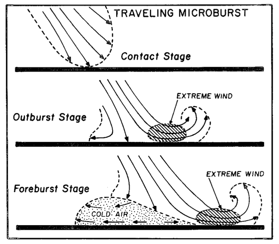
Microbursts are produced by strong downdrafts that fan out when they contact the ground, as depicted below.
Source: Fujita (1981)
Yesterday's was a traveling microburst similar to the schematic above, initiated by virga (precipitation aloft) falling from shallow mid-level clouds near the Oquirrh Mountains.  The afternoon sounding from the Salt Lake City airport, collected around the time of the microburst, shows a remarkably dry lower atmosphere with what is known as an "inverted-V" sounding.  Clouds are based just below 500 mb (probably about 8500 feet above ground level) and below the cloud the sounding is remarkably dry, with a 58˚F dewpoint depression at the surface (equating to a relative humidity of only 12%).

Source: SPC
Thus, precipitation from aloft falling into this dry airmass let to dramatic cooling and the formation of a downdraft and microburst winds.

Microburst winds can be very dangerous for aviation and can produce damaging straight-line winds.  In the future, they will be a serious concern for drones, which are being used increasingly for deliveries of all sorts of products.  For example, yesterday's winds would have been above the recommended operating threshold of some (maybe all) drones that are currently being developed for for commercial deliveries of packages of 5 pounds or less.

Southern Utah

At least one person is dead due to flash flooding produced by a thunderstorm near Goblin Valley in the San Rafael Swell south of I-70 and north of Hanksville.  Below is a radar image showing what I believe is the storm at upper right, just northwest of HVE, the abbreviated identifier for Hanksville.

Source: NCAR/RAL
Radar imagery shows storm initiation over the 11,000 foot high Thousand Lake Mountain Plateau north of Torrey and then proceeding to the Goblin Valley area.  Apologies for the crappy video below (source: NCAR/RAL), but I'm working on borrowed time right now. 


There are several popular slot canyons in that area, including Little Wildhorse.  The video below was shot by Atmospheric Sciences graduate student Tom Gowan who was in the area.

Media reports suggest that in addition to one confirmed fatality, some vehicles remained at the trailhead overnight.  Hoping for the best as search-and-rescue operations resume this morning.