Northern Utah
In northern Utah, convective storms produced strong microburst winds in several areas, resulting in a few downed tree branches and a lot of blowing dust and pollen. The tweet below includes a video showing dust and probably pollen kicked up by microburst winds moving through downtown Salt Lake City.
There were some downed tree branches reported near Liberty Park according to NWS reports.Updated loop of afternoon microburst in Salt Lake City. Watch how dust/pollen/or whatever cloud moves through downtown. Initiated early in loop by virga near Oquirrh Mts. Possible reinforcement west of downtown. #utwx pic.twitter.com/d6GTQAJU7p— Jim Steenburgh (@ProfessorPowder) May 12, 2020
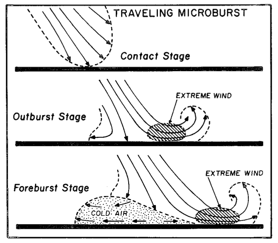
Microbursts are produced by strong downdrafts that fan out when they contact the ground, as depicted below.
 |
| Source: Fujita (1981) |
 |
| Source: SPC |
Microburst winds can be very dangerous for aviation and can produce damaging straight-line winds. In the future, they will be a serious concern for drones, which are being used increasingly for deliveries of all sorts of products. For example, yesterday's winds would have been above the recommended operating threshold of some (maybe all) drones that are currently being developed for for commercial deliveries of packages of 5 pounds or less.
Southern Utah
At least one person is dead due to flash flooding produced by a thunderstorm near Goblin Valley in the San Rafael Swell south of I-70 and north of Hanksville. Below is a radar image showing what I believe is the storm at upper right, just northwest of HVE, the abbreviated identifier for Hanksville.
 |
| Source: NCAR/RAL |
There are several popular slot canyons in that area, including Little Wildhorse. The video below was shot by Atmospheric Sciences graduate student Tom Gowan who was in the area.
Media reports suggest that in addition to one confirmed fatality, some vehicles remained at the trailhead overnight. Hoping for the best as search-and-rescue operations resume this morning.After we found a high, sheltered spot, all hell broke lose. Heavy rain turned into the heaviest nickel-sized hail I've ever seen. After several minutes, we noticed a debris flow coming down Bell's Canyon. Video (warning: language): pic.twitter.com/o4hH4DQnjQ— Tom Gowan (@tommgowan) May 12, 2020

No comments:
Post a Comment