Posts

Showing posts from May, 2025

Signs of the Times

Image
These are minor issues compared to what many are dealing with, but yesterday I received two e-mails that are reflective of the times.  In the first, I was notified that a proposal I submitted to a NOAA Weather Program Office competition was recommended for funding.  Normally this is good news, but this year, that news was accompanied with the caveat that they probably won't be able to find funding.   That would be a shame because we were planning on using deep learning to further advance the the techniques approaches we've been developing to improve snow density and snow amount forecasting.  Many of the products on weather.utah.edu and features on this blog use experimental versions of these techniques.  Without support, this line of research will probably whither in the coming months as our current grant winds down (and this assumes that funding is not frozen).  In the second, I was notified that I was eligible for the Voluntary Special Retirement Pro...
Death of a Snowpack

Image
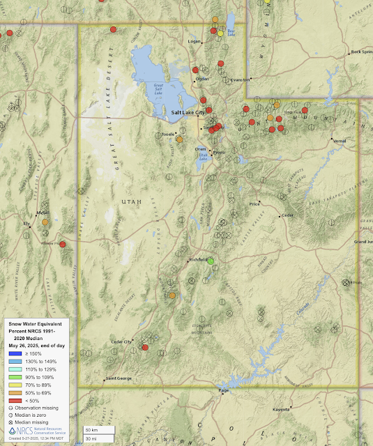
A look at the latest snowpack water equivalent numbers from Utah SNOTEL stations shows that most are now snow free. Source: NRCS Don't be fooled by the red dot in southwest Utah.  That's the Midway Valley SNOTEL and it hit zero on May 15.  The red fill is spurious.  There are only two other sites in Utah with measurable snow, Big Flat (orange) at 10,320 ft in the Tushar Mountains, and Farnsworth Lake (green) at 9,620 ft in the mountains east of Richfield.   The northern Utah snowpack is also non-existent at most SNOTELs [and some of the red dots above are also spurious and there's no snow at the site (e.g., Ben Lomond Peak, Lookout Peak, Brighton)].  Those with measurable snow are at high elevations and only one, USU Doc Daniel (yes, that's the name) is over 70% of median (and it's at 71%).   I actually don't like using the percentage of median this time of year.  Instead, I look to look at how many days ahead of median the melt out is. If we...

Withering Summer Skiing

Image
In March, Whistler Blackcomb announced that they would be cancelling summer ski camps indefinitely.  Yesterday, Powder Magazine reported that this was due to declining summer conditions on the Horstman Glacier. Source:  https://www.powder.com/news/whistler-blackcomb-summer-skiing-cancelled Summer skiing is in decline worldwide.  I investigated this for my book, Secrets of the Greatest Snow on Earth.  In 1985 there were 32 operating glacier-skiing resorts in the Alps.  Today there are only a few that operate for a significant part of the summer (Passo Stelvio, Saas Fe, Kitzsteinhorn, Mölltal, Les 2 Alpes, Ignes, Val d'Isere, Cervina, Hintertux, Zermatt).   Hintertux in Austria is the only ski area in the world still operating year round.  Zermatt used to, but gave up the past two years (maybe they will survive this year).  Hintertux moves Heaven and Earth to keep their skiing going through the summer.   Source: Steenburgh (2023)...

Declines in Awards from the National Science Foundation

Image
Those of us who work at Universities and other scientific organizations are well aware of the cuts, layoffs, and damage affecting the American science enterprise under the Trump Administration.  An article published today in the New York Times describes what is happening specifically at the National Science Foundation (NSF), which for 75 years has supported research and education in science and engineering.   In addition to the termination or freezing of grants related to diversity, equity, and inclusion (DEI), social justice, and misinformation/disinformation, funding awarded from January 1 to May 21st of this year by the NSF declined 50% from the 2015–2024 average. The declines were largest in the education directorate, followed by math, physics, and chemistry; engineering; and biology.  Technically, these are declines in awards given.  The available funds could be doled out later in the fiscal year.  However, even if funds are eventually doled out, thes...

Who Knew It Snowed So Much at Sundance?

Image
I was pretty surprised to see this from the Salt Lake Tribune this morning.  I had to check the calendar to see if it was April Fools.  It was in their online article discussing Sundance's planned expansion .   520" of snow and more than 100" of base is pretty darn good.  Alta clocked in with 538" and currently has a 95" base.  End of snowcover at the Timpanogos Divide SNOTEL at 8,180 feet, pretty close to the summit elevation of Sundance Ski Resort, was May 4.   Who knew there was such a great microclimate on the south shoulder of Mt. Timpanogos. Lol. Perhaps this is a leftover from 2022/23 that somehow snuck into the online article.  

Mid May Powder?

Image
Spring powder has been limited this season with April and early May coming in relatively dry, warm, and at times windy and dusty.   In April, Alta recorded 53.5" of snow, but 37.5" of that was on the first three days of April.  Automated obs suggest about 10" on the 6th of May and we gotten perhaps 4" yesterday.   So if you are still looking for a late-season powder fix, Sunday has some potential.  The models are hinting at a digging trough and front to be moving through Sunday morning.  The GFS, for example, puts the front right over nothern Utah at 1500 UTC 18 May (9 AM MDT Sunday).   Some of the models then call for unstable northwesterly flow thereafter, although the moisture, wind direction, and instability do vary some.   For Alta-Collins, the GFS puts out 0.94" of water and 9" of snow from Saturday evening through Sunday evening, most of which falls with the frontal passage Sunday morning.   The median forecast from...

Dusty Days

Image
The past to days were quite dusty thanks to strong south winds in advance of a slow moving cold front that finally moved into the Salt Lake Valley last night.  Yesterday was the worst of it with dust filling the Salt Lake Valley in the afternoon, creating and apocalyptic scene.   Scene looking south over the Salt Lake Valley from the upper Avenues at 6 PM Observations from the University of Utah over the past two days show persistent southerly flow on Sunday with peak gusts reaching 40-45 miles per hour.  Those winds died down Sunday night before strengthening Monday morning.  The strongest winds of the period occurred Monday with gusts > 35 mph common from about 1100 to 2100 MDT and a peak gust of 48 mph.   Source: MesoWest A look at MesoWest data shows many valley locations in central and western Utah had peak gusts more than 50 mph.  A few examples include Parowan (61), Curlew Junction (60), Stockton (60), Simpson Springs (58), Baccus/SR111 ...

Could Snow Storage Work in Utah?

Image
It's that time of year when I wish we could save some of the snow from this season for next season.  There's a dense snowpack at upper elevations and wouldn't it be great if we could save just some of it for next year. Some resorts in Europe have been doing that, piling up snow and covering it with white, insulated blankets or sawdust to save it until next season.  Levi in Finland is perhaps best known for doing this (see  https://www.wired.com/story/ski-resorts-are-stockpiling-snow-to-get-through-warm-winters/ ).  Now Sun Peaks Resort has become the first resort in Canada to do it. Per the video above, they invested $170,000 (presumably CDN) for geotextile blankets to preserve snow for next season to use it in late fall and early winter.   I don't know enough about resort economics, snowmaking costs, or snow energy balance to evaluate whether or not this would work here, but I'm intrigued.  Beyond costs, one advantage of this approach is that the pres...

Last Day of 100 at Alta?

Image
At 1 PM MDT this afternoon, the total snow depth at Alta Collins dropped to 99", falling below 100" for the first time this melt season.  There are a couple of cold troughs coming next week so a recovery is not impossible, but given that we're losing about 3" a day right now and have a couple warm days ahead, the odds are such that today was probably the last with a 100" snow depth this season.   Cover in Collins Gulch remains excellent.  The snow earlier this week buried the snirty snow surface in some areas, especially on high north, making for a bit of a white corn harvest at upper elevations.   Photo: Erik Steenburgh Photo: Erik Steenburgh Although there was a shallow freeze overnight thanks to the radiative cooling of the snow surface, given the warmth (the overnight low at Collins was 43) and the high elevation sun, it didn't take long for things to soften up anywhere that was in the sun.  We were off the mountain at 11 and eating tacos in the sh...

NSF Cuts Shutter NSF Unidata

Image
There's an organization you may have never heard of, but if you are a user of weather data and graphics on the web, they have almost certainly contributed to the cyberinfrastructure that made it possible. Their name is NSF Unidata , or just "Unidata" for short.   Unidata developed organically in the 1980s when Universities has a pressing need to access weather data in real time, but couldn't.  The Internet at the time was nascent and there was essentially no hardware and software systems capable of delivering, processing, and analyzing weather data.  In 1983, a workshop at the University of Wisconsin involving about 80 US atmospheric sciences programs coined the name "unidata" and recommended that it be developed to provide: Access to current and archived weather data, including satellite imagery and forecasts. Support interactive computer capabilities at universities. Communications capabilities between universities, the National Center for Atmospheric Rese...