Showing posts with label Runoff. Show all posts

Friday, May 12, 2023

The Big Melt

Snow is melting and the decline in lower-to-mid elevation snowpack has been impressive.  

The lowest SNOTEL in the Wasatch Range is Ben Lomond Trail in the northern Wasatch (5972').  Snowpack water equivalent has dropped like a stone there from its all-time 47" peak (with records going back to 1981) to 17.1 inches yesterday.  It remains at an all-time high, ahead of 2011, 1984, and 1983.  Based on the forecast, I suspect it will probably make it about another 10 days before becoming snow free.

Source: NRCS

In City Creek Canyon, the low-elevation Louis Meadow site (6700') has also seen an incredible decline from 43.3 to 13.1 inches.  It's now behind where the snowpack was in 2010/11.  

Source: NRCS

A bit higher on Lookout Peak (8161'), the big melt has just begun and has been slower.  Although now behind the 2010/11 snowpack, 45" of water remains.  Streamflows in City Creek are forecast to increase in the coming days as this upper-elevation snowpack begins to melt in earnest.  

Source: NRCS

The Parley's summit snotel has a long period of record going back to 1979.  At 7,585', this site has shed a bit over half of its snowpack and it is behind 2011, 1984, and 1983.  It might have about 10 days of snow cover left.  

Source: NRCS

Finally we have the high elevation Snowbird snotel (9177 ft).  You may recall a blog post from a couple of weeks ago (Snowbird SNOTEL Measurement Oddities) in which I discussed how it strangely climbed and reached a new all-time high.  It appears the NRCS has corrected that provisional data, so the site now shows no record peak.  Melt has not begun in earnest yet, but it has shed a small amount of water and it currently sits behind 2011 and 2005.  Still there is a lot of water to come down from the upper elevations.  

Source: NRCS

By and large, I think the situation right now is perhaps the best we could have hoped for given the enormous snowpack that existed in April.  The runoff has produced some flooding and damage in places, but given the enormous snowpack, we have been able to shed a good fraction of the lower and mid-elevation snowpack while the upper-elevation snowpack on north aspects has been ripening but not releasing a lot of water.  In the Salt Lake area, the worst may be over in terms of snowpack runoff for Emigration Creek, which drains a lower elevation basin, but creeks draining higher elevation basins, like City Creek and the Cottonwoods, have big water to come.  

Monday, May 1, 2023

Snowbird SNOTEL Measurement Oddities

Those of you keeping score at home know that through last week, the Snowbird SNOTEL had still not eclipsed the peak snowpack water equivalents reached in the 2005 and 2011 water years.  

However, things changed over the weekend.  

On April 26th, the snowpack water equivalent was 72.3", the highest of this season, but a shade lower than the 75.1" reached on two dates in 2001 and the 74.6" peak in 2005.  However, from April 26th to 30th, the snowpack water equivalent rocketed upwards to 76.2", a new record.  

Source: NRCS

How did this happen?  Certainly not from snowfall, as the last storm was on April 25th and would have been accounted for by the measurement on the 26th.  The 26th was a spectacular day with great skiing in the wake of that storm and on the 27th the site recorded 72.0", just a shade lower than the 26th.  Then from the 27th to the 28th the measurement jumped to 75.2", despite there being no significant precipitation.  The 27th was a very windy day and perhaps the wind deposited snow over the pillow.  However, it went up even further to a peak of 76.2" on April 30.  How could this happen?  

SNOTEL stations measure snowpack water equivalent using a snow pillow with a pressure transducer.  The snowpack weight of the snowpack presses down on the pillow, resulting in pressure reading that can be converted to a water equivalent.  

Source: NRCS

The pillow, however, simply measures pressure.  It doesn't say anything about where that pressure came from.  Increases could be due to snowfall adding weight to the snowpack, but also other factors like wind transport adding to the snowpack over the pillow, or water moving horizontally through the snowpack during melt periods. A strong layer in the snowpack can also result in bridging, with the snow above the bridge not fully contributing to the weight of the snow.  If the bridge weakens, then there can be an increase in measured water equivalent.  

Snowbird isn't the only location showing this behavior.  Lookout Peak jumped 2" from April 26 to April 28 before dropping a bit through today.  That increase, not associated with precipitation, also pushed Lookout Peak to a record snowpack water equivalent.  

Source: NRCS

Those are a couple of the curious measurement oddities evident over the past couple of days and a reminder that SNOTEL time series are not just a reflection of precipitation or melt.  

That said, we can also have a look at stations where the snowpack has ripened (i.e., warmed to the melting point through the entire depth of the snowpack) and net melting are occurring.  A good one is Parleys's Summit.  On April 28th, snowpack water equivalent was 32.9" and in 3 days it has dropped over 5" to 27.7".  The decrease yesterday was 2.2".  Pretty impressive for the last day of April. 

Source: NRCS

With a warm night last night, a decent amount of sunshine, and another day near or above record highs,  expect the impressive snowmelt to continue at Parley's and other areas where the snowpack is ripe.  

Addendum 2 May 2023:

NRCS appears to have done some quality control of the Snowbird data. When I pulled it up this morning, the big increase was reduced and values were below the 2011 water year maximum.  

Source: NRCS

Wednesday, April 7, 2021

April Powder Brings June Flowers

It's impossible to know when we will have the season's last powder day, but if today was it, that's OK.  

With perhaps 15-20 cm of new snow, Room of Doom in upper Mineral Fork was ours this morning.  One could feel the stout melt-freeze crust at times, but the skiing was still fun.  

Given our fair snowpack conditions, this storm was desperately needed.  We need more, but every little bit helps.  Some of the moisture from this most recent snow will evaporate into the atmosphere.  Some of it will be used by plants.  Some of it will recharge our soils, which are remarkably dry.  And some of it will enter Big Cottonwood Creek and provide the water we all need for taking showers, flushing toilets, and watering gardens.  Thus, it is not a stretch to say that April powder brings June flowers, at least in this part of Utah.  

The view below from the top of our climb shows the upper reaches of the vast Mill-B South drainage, also known as Lake Blanche Fork.  What you see in white is our summer water supply and one of Salt Lake City's most important water towers.  

Let's give thanks for the snow we have and hope that next season is better.  


Friday, May 1, 2015

The Slow Death of the 2014/15 Winter Snowpack

Although it might not seem like it because it happened early, our snowpack suffered a remarkably slow death this winter.

Below is a graph showing the snowpack snow water equivalent at the Mill-D North Snotel in Big Cottonwood Canyon during this past winter (green), the average winter (blue), and the exceptional 2010/11 winter (red).  During the 2010/11 winter, we not only had a huge snowpack, but after a gradual draw down in May, the melt rate in June was stupendous and averaged about 1.67" per day.  If you want a big melt rate, it helps to have a healthy snowpack survive until deep into the warm season when the the sun angle, temperature, and day length are maximized.


In contrast, this year was characterized not only by a below average snowpack, but also a very gradual melt rate.  The decline in snowpack from a peak of 14.6 inches on March 10th to near zero on April 23rd represents an average melt rate of only 0.33" per day.  Warm springs lead to a more gradual snowmelt due to the more modest sun angle, temperature, and day length.

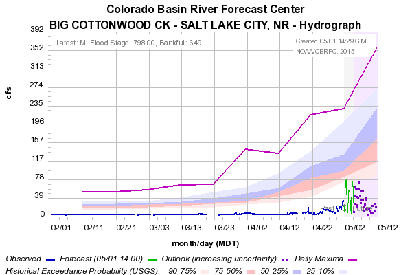
Little wonder why this year we've seen barely a trickle coming out of the Cottonwood Canyons.  That pathetic blue line in the charge below is the observed runoff at the mouth of Big Cottonwood Canyon.  The transition from pink to blue represents the median.

Friday, April 24, 2015

Dr. Seuss on Western Hydroclimate

Snow remains in the forecast and hopefully we'll have some white stuff this weekend for Alta's closing day #2, to help Snowbird extend their season, and perhaps to give us an extra week or so of white corn in the backcountry.  However, I have something more entertaining to share than a discussion of the weekend forecast.

Jeff Lukas is a research scientist with the Western Water Assessment.  He recently presented a Dr. Seuss inspired summary of recent and future climate and water trends for Colorado that has gone viral amongst my colleagues.  It's worth a 5 minute look and does an excellent job summarizing current knowledge of our changing hydroclimate.


Although emphasizing Colorado and the recently completed report, Climate Change in Colorado, it is quite applicable to Utah.  

Monday, June 9, 2014

The Insidious Loss of Snow during the Past Month

Albion Basin and Greeley Hill, 8 June 2014
Loss of snowpack in May and June is pretty much the way things work in Utah, but this year, the decline has been remarkably steady and consistent.

On May 11th, the snow depth at Alta-Collins sat very near its maximum for the year at just under 120 inches.  At that time, the snowpack was fairly consolidated and ripened, meaning it has warmed to 0ºC throughout its depth, so additional energy input from above freezing temperatures and solar radiation would result in snowmelt.  

Source: MesoWest
Indeed, it was just a couple of days later that temperatures popped up to near or above average and, despite some ups and downs, they have stayed there for nearly a full month.  

Source: NWS
Indeed, since May 15, there hasn't been a single day at Alta with a below average maximum temperature and only one day with a below average minimum temperature (and that was only by a degree).  We've also had little in the way of cloud cover during this period, and most of the energy that melts snow comes from the sun.  Basically, if you want to melt snow in Utah, it's best to have above average temperatures, lots of sunny days, and dirty, dusty snow.  We have all in spades this year.  

This has led to a non-stop decline in snow depth at Alta–Collins.  If you look carefully at the graphs above, you can also see that the rate of snow depth decline increased around May 25th, which is also when there was somewhat of a step up in the temperatures (especially the maximum temperatures).  Since that day, we've been losing about 2.8 inches of snow a day.

On May 19th, I guestimated Alta-Collins would lose all its snow around June 27th.  That's still looking like a decent guess, although the current melt rate would bring an end to snow cover at that location at around June 25th.  

Sunday, April 20, 2014

The Deception of City Creek Canyon

City Creek Canyon has to be one of the most remarkably accessible and spectacular canyons in the United States.  It's mouth is just a couple of hundred yards (if that) from downtown Salt Lake City, with the upper basin reaching altitudes of over 9000 feet.  It is also an important source of water for Salt Lake City.

Looking up the canyon from the Avenues foothills this afternoon makes you wonder where all that water comes from.  It was a poor snow season in the lower elevations and, remarkably, there's already very little snow visible in the canyon.


Indeed, the Louis Meadow SNOTEL at 6700 ft in City Creek Canyon bottomed out and went snow free today.  However, City Creek is a very deceptive canyon.  It is very hard to see City Creek's upper basin (purple area below) between Grandview Peak (also pictured above) and Lookout Peak (blocked in the photo above by Black Mountain) from either downtown Salt Lake City or the Avenues foothills (approx location and view of photo indicated by triangle).


If one looks at the Lookout Peak Snotel, just east of City Creek's upper basin at at an elevation of 8200 feet, one finds that the snowpack actually peaked a bit above average and is currently near average for this date.  A hint of this can be seen in the photo where you can just see some of the snow on Grandview.  Altitude makes a big difference this year.

Source: CBRFC
Given the pathetic low-elevation snowpack, the total runoff volume in City Creek will probably be below average this year, but the high elevation snowpack should keep some natural flow going through the spring.

Tuesday, June 4, 2013

The Dry Season Begins

Lush grass and gardens in the Avenues at the start of June.
There is no official start of the dry season, but June 1st serves as a reasonable demarkation as June, July, and August are the only months that average less than an inch of rain at the Salt Lake City International Airport.

We head into the dry season with the valley looking lush (by Utah standards).   It's actually quite remarkable how green everything is given that May brought only 1.26 inches of rain to the Salt Lake City Airport, compared to an average of 1.95 inches.  That rain, however, was fairly well distributed with .54 inches falling from May 17–20 and then .63 inches falling from May 28–29.  

That's the good news.  The bad news is that our spring runoff is already almost over.  Most SNOTEL stations have no snow (white squares) or less than 25% of average snowpack snow-water equivalent (SWE, dark red squares) for early June.  The only site at more than 50% of average is Lakefork Basin in the Uintas, which sits at 71%.

Source: NWS/CBRFC
The Snowbird SNOTEL has been dropping like a rock through May and it looks like it will bottom out  by tomorrow.  That would be 12 days ahead of the median day of snow cover loss and well ahead of average.

Source: NWS/CBRFC
For the second year in a row, we're going to be leaning heavily on the storage in our reservoir system.  

Sunday, June 2, 2013

A Green City Creek Canyon


There are just a few patches of snow in the upper basin, which are nearly impossible to discern in this photo.  Yeah, this is June 2nd!  I'm guessing we won't be getting much water from this canyon this year.

Thursday, May 23, 2013

Benefits of a Relatively Dust Free Spring

Over the past few years, we have seen a number of wind-blown dust events, especially in the spring, which have turned our precious Greatest Snow on Earth into the Greatest Snirt on Earth (Snirt=part snow part dirt).  These dust events are typically "recorded" in the snowpack as dirty layers, which collect on the snow surface during the spring melt.  The intensity and frequency of dust events vary from year to year depending on meteorology and land surface conditions.  Below are examples of relatively clean and dirty spring snowpacks in the Wasatch Mountains.

This year has been relatively dust free.  I haven't been up in the Cottonwoods for a while, but reports suggest that the snowpack is relatively clean and that was the case in April when I last made turns.  Yesterday, however, we saw some wind-blown dust over the Salt Lake Valley, with some obscuration of the visibility both in the pre- and post-frontal environment.  


The lack of dust events is good for skiers.  It makes for better spring skiing, but also a longer ski season since it results in a longer duration of snow cover in the mountains.  Dirty snow is darker and absorbs more sun than clean snow, resulting in a faster snowmelt.

Courtesy: Tom Painter, NASA/JPL
It's also good for skiing, and modeling studies suggest that it might be good for runoff too, which should make water managers and users happy given that this otherwise was a below average year.

Friday, April 19, 2013

Some Breathing Room

The cool, intermittently wet pattern over the past couple of weeks has likely provided just a bit of breathing room for water managers in northern Utah, with one more storm to come tonight and tomorrow.

We discussed previously the meager snowpack that existed at the end of March.  Not much has changed at lower elevations where much of the precipitation that has fallen in April has either been rain or wet snow that melted quickly between storms.  For example, the Ben Lomond Trail SNOTEL (~6000 feet) bottomed out earlier this month with no real recovery (green line).  This is about a month earlier than their median date of the loss of snow cover (purple line).

Source: CBRFC
Things look better, however, at some (but not all) upper-elevation sites.  In the Cottonwoods, both Mill-D North (8960 ft) and Snowbird (9640 ft) have gained snowpack this month.  At Mill-D North, they are often losing snowpack this time of year (see purple and blue lines), so thats a net positive, putting them well ahead of where they were last year, but still just a bit below the snowpack peak and the average for this time of year (red line).  At higher-elevation Snowbird, however, accumulation rates have only been sufficient for them to keep up with the pace of snowpack growth that is typical until late April.  Nevertheless, that's better than losing ground.  


Source: CBRFC
Skiers should take note that the snowpack at Snowbird is now just a shade ahead of the peak from last year.  Hooray!  The snow depth at Alta-Collins reached 117 inches this week.  So close to 10 feet!  Better late than never.  

Further east, the snowpack in the high-altitude Uinta Mountains actually looks pretty good.  Many sites sit near or above average.  

Source: CBRFC
Major gains have occurred in the Uintas this month.  Check out the increase in snowpack at Trial Lake, which is now sitting just above the median and average peak snowpack and well above last year.

Source: CBRFC
On the other hand, there are some areas in northern Utah that Mother Nature completely abandoned.  Neither Ben Lomond (8000 ft) nor Timpanogos Divide (8100 ft) ever got anywhere near a decent snowpack and they haven't recovered much in April either (they are the red boxes in the plot above).

As we have said many times this year, it ain't over until it's over, but based on the longer range (6-14 day) forecast, this weekend might prove to be this season's upper-elevation snowpack peak.  In most areas, it won't be a great runoff year and the total volume will likely be below average, but it won't be as bad as last year either.  

Sunday, March 31, 2013

Easy Come, Easy Go

Surely you remember it.  That unbelievable low altitude snowpack we had this winter.  I do.  This is what the Avenues foothills looked like on January 11.


Here's the view up City Creek Canyon from the Avenues foothills today.


City Creek Canyon is one of several that provides water for the Salt Lake Valley.  Things are looking grim for runoff this year.  There is a SNOTEL station at 8200 feet in City Creek on the slopes of Lookout Peak, the snowy mountain on the horizon in the photo above.  With a snowpack SWE of 18.8 inches, it presently sits at only 73% of average for today.

Source: NWS/CBRFC

Tuesday, March 26, 2013

Reality Sets In

Our brief flirtation with winter is over and while the snow was greatly appreciated by skiers, it put only a small dent (if that) in the snowpack deficit that presently exists in the central Wasatch and elsewhere in the western U.S.

The latest snowpack snow-water equivalent analysis shows only a handful of basins presently sit above average.  These basins are located in the Olympic and Cascade Mountains, as well as interior ranges near the Canadian border.  All basins in the upper Colorado and Great Basin are below average.
In the central Wasatch, Snowbird, Mill D North, and Thaynes Canyon are at 77–84% of average.  Although Mill D and Thaynes Canyon are thankfully above last year, Snowbird is pretty much neck-and-neck with it.


Source: NWS/CBRFC
April 1st is not only April fools day, but typically an important date for anticipating the spring runoff.  It is close to the average time of peak snowpack at many locations in the west, although that peak is a bit later at upper elevation sites like Snowbird.

The forecasts through April 1st suggest that the snowpack in Utah and the adjoining upper Colorado Basin and Great Basin will slip further into the red.  It won't be bone dry as we may see some spring showers, but there's little hope of a big dump through the end of March.  A spring miracle is needed in April if we are to avoid a second consecutive year of meager runoff.

Tuesday, March 12, 2013

Spring Runoff at Risk

It's not time to panic yet, but I've been looking at the forecast for the next couple of weeks and it is bad news for the spring runoff.  Much can happen in late March and April, but it appears we will need to make up a lot of ground if we are to have anything close to a decent runoff this spring in the Great Salt Lake Basin.

First, let's have a look at the current snowpack situation.  The Bear, Weber, Ogden, and Provo/Jordan river basins are all sitting at about 75% of average snowpack.

Source: NRCS
This week, we have a high-amplitude ridge building in.  The 700-mb temperatures are forecast to climb to about +5ºC over Salt Lake City by Thursday afternoon.


Thursday will easily be the warmest day of the year.  Portions of the Salt Lake Valley will see maximum temperatures in the low 70s.  I think 70ºF will be broken at the Salt Lake Airport if the lake breeze is kept at bay.

All of this means that we will be chipping away at the mountain snowpack during a month that is critical for building the snowpack for the spring runoff.  Ideally, you want the mountain snowpack to build into April, followed by a rapid melt and runoff pulse over about a six week period during the late spring.  This maximizes the fraction of snow that is converted to runoff.  A slow melt of a meager snowpack over an extended period results in a weaker pulse.  Not only is the water stored in the snowpack lower, but the fraction of snow converted to runoff is lower because you lose more of it to evaporation, sublimation (ice converting to water vapor), and transpiration by plants (once they become active).

The models suggest a gradual cooling trend after Thursday, but we're only brushed by some weaker systems through the middle of next week.  Thereafter, the forecast suggests the dice are loaded for below average precipitation through March 25th.

Source: CPC
As indicated on the Snowbird SNOTEL plot below, the trajectory is not good.  Chances are pretty good that we will be behind last year's snowpack if the forecast holds.

Source: NWS/CBRFC
As I mentioned, a lot can happen in the spring, but the odds we can recover dwindle with each passing day and week.  Enjoy the spring conditions now, but hope for a return of winter later.

Sunday, May 20, 2012

Hidden Water

One of the more remarkable aspects of the Wasatch Mountains and the western United States in general is how incredibly "plumbed" the rivers and streams are.

We observed this yesterday on our hike in Neffs Canyon, which rises into the Wasatch Mountains east of Olympus Cove and just south of Mill Creek Canyon.


Neffs contains a perennial stream that is fed by snowmelt and, in the upper canyon, there's still a reservoir of scattered snow.  We even did some poor-man's skiing, here at an elevation of about 8600 ft.


Not surprisingly, there's a healthy stream fed by snowmelt and running down the upper canyon.


But here's what the stream bed looks like in the lower canyon.


It appears that the water is being captured somewhere in the canyon, perhaps just outside the wilderness area boundary, which was clearly drawn around the stream (see red line above).

The Hidden Water web site provides quite a bit of information about the major drainages above the Salt Lake Valley.  It states that the Salt Lake City Department of Public Utilities owns the water rights to four springs in the canyon, but I couldn't find anything on water extractions from the stream.  Presumably they own the rights to the stream as well and are taking all they can this year given the drought conditions.  Perhaps the water ends up, at least temporarily, in the water tank that sits along the trail just above the parking lot.

Sunday, June 26, 2011

Thar She Goes!!!

It is quite remarkable just how much snow has melted in the Wasatch over the past week.  After nearly 8 months of incredible skiing, the snowpack is finally looking and skiing "tired', especially on south facing aspects.

Grizzly Gulch, 9000 ft elevation, 26 June
Over the past three days, the Snowbird SNOTEL has lost almost 9 inches of SWE and is now down to just over 30 inches (its May peak was 75).  Thus, about half the snow at this site is gone.


Similarly, the Collins snow stake has dropped from 193 inches to 123".  Can we make July or perhaps the 4th with 100"?  I think the former is possible, but the latter is going to be close.


Roaring torrents of water are cascading down every canyon.  Little Cottonwood Creek is a "white ribbon of hell" pulverizing everything in sight.


Standing next to the creek, the ground literally shakes.  For a bit more perspective, click here for a video.     She can't take much more of this captain!

Despite the melt and increasingly tired snow, there's still good coverage above 8500 feet on aspects on the north side of the compass, for those of you who simply must make turns.

Devils Castle, Sugarloaf Peak, East Greeley, and Greeley Bowl
26 June 2011.  
And despite my view that the snow is tired, my son still thinks the skiing is great.  I couldn't help but share this photo of him cresting out today above Wolverine Cirque.  Great job kid!