Snow is melting and the decline in lower-to-mid elevation snowpack has been impressive.
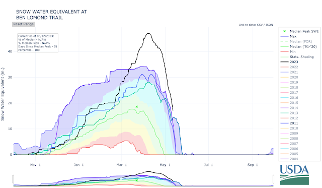
The lowest SNOTEL in the Wasatch Range is Ben Lomond Trail in the northern Wasatch (5972'). Snowpack water equivalent has dropped like a stone there from its all-time 47" peak (with records going back to 1981) to 17.1 inches yesterday. It remains at an all-time high, ahead of 2011, 1984, and 1983. Based on the forecast, I suspect it will probably make it about another 10 days before becoming snow free.
 |
| Source: NRCS |
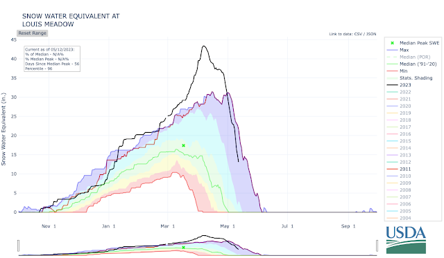
In City Creek Canyon, the low-elevation Louis Meadow site (6700') has also seen an incredible decline from 43.3 to 13.1 inches. It's now behind where the snowpack was in 2010/11.
 |
| Source: NRCS |
A bit higher on Lookout Peak (8161'), the big melt has just begun and has been slower. Although now behind the 2010/11 snowpack, 45" of water remains. Streamflows in City Creek are forecast to increase in the coming days as this upper-elevation snowpack begins to melt in earnest.
 |
| Source: NRCS |
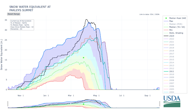
The Parley's summit snotel has a long period of record going back to 1979. At 7,585', this site has shed a bit over half of its snowpack and it is behind 2011, 1984, and 1983. It might have about 10 days of snow cover left.
 |
| Source: NRCS |
Finally we have the high elevation Snowbird snotel (9177 ft). You may recall a blog post from a couple of weeks ago (Snowbird SNOTEL Measurement Oddities) in which I discussed how it strangely climbed and reached a new all-time high. It appears the NRCS has corrected that provisional data, so the site now shows no record peak. Melt has not begun in earnest yet, but it has shed a small amount of water and it currently sits behind 2011 and 2005. Still there is a lot of water to come down from the upper elevations.
.png) |
| Source: NRCS |
By and large, I think the situation right now is perhaps the best we could have hoped for given the enormous snowpack that existed in April. The runoff has produced some flooding and damage in places, but given the enormous snowpack, we have been able to shed a good fraction of the lower and mid-elevation snowpack while the upper-elevation snowpack on north aspects has been ripening but not releasing a lot of water. In the Salt Lake area, the worst may be over in terms of snowpack runoff for Emigration Creek, which drains a lower elevation basin, but creeks draining higher elevation basins, like City Creek and the Cottonwoods, have big water to come.

No comments:
Post a Comment