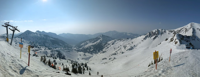
It's never over until it's over, but yesterday was probably my last day of resort skiing for the season.
It was an unusual last day, with smoked filled skies from the Canadian wildfires.
Friday night lows at the top of Hidden Peak were only 39˚F, yet there was a solid freeze of the snow on the mountain thanks to clear skies and long-wave radiative cooling. Regulator was "not recommended" first thing and I can confirm that the ski patrol was on point. With early sun, Mineral offered up soft skiing quickly due to its easterly and southerly exposures, but I'm always happier when the steeper lines off the tram can be skied. North Chute and the like with May morning sun exposure began to soften up and ski well around 10:30.
It will be interesting to see if Snowbird can make July. There is still an enormous amount of snow on the upper mountain. Water equivalent at the SNOTEl site, although now well below where we were in 2010/11, is still in the top 10% of snowpacks on May 21 since 1990.
That said, the warmth of this May has shed about 20 inches of water equivalent at the SNOTEL site, the snowpack is fully ripe, and it is extensively dust covered. A shift to cooler weather would probably be helpful.


.png)
Can you recommend the best site to see satellite imagery of the smoke plume into Utah from the Canadian wildfires. If you wanted to do a post I would read it ... just saying
ReplyDeletehttps://fire.airnow.gov/
DeleteHave you seen the RAP Smoke forecast(HRRR) too; neato! https://rapidrefresh.noaa.gov/RAPsmoke/ Vertically Integrate press the "loop" check mark
DeleteThanks for link anonymous.We were affected on a hike to 8000 ft yesterday. Runny noses etc.. Questioning whether this is good for our health, given purple air #s in the orange.
ReplyDeleteI still don't get why the plume is moving so far south. Is this grand scale turbulence? Or the positioning of high and low pressure?
Probably passed like two ships in the night at Snowbird yesterday. It was a stellar day and we had hoped to get a shot at Pipeline or something on the Mineral side of the ridge... it wasn't to be so we jaunted over to Alta and did the Main Chute, which is still primo (but soggy and heavy). More warm wax would have been a help espesh on any traverses (which were pretty dirty). We then dropped down Keyhole and skied back into Snowbird, all of which was great for this time for the year. The SOUTH facing Superior and east ridge still have what appears to be plenty of snow... Again, wow. And the band in the Tramyard was really good!
ReplyDeleteAnyway, thanks for all of the great weather beta this entire season and hope you keep it coming. Next level weather reporting is always super interesting, and meaningful, epesh here in the mountain west.