 |
| Peering into Wasatch Range and Little Cottonwood Canyon with the DOW |

Showing posts with label SCHUSS. Show all posts
Showing posts with label SCHUSS. Show all posts
Tuesday, November 22, 2011
Trib Article
A nice article appeared on the Salt Lake Tribune web site this evening about our activities with the DOW. I especially liked that our graduate students were prominently featured as they are the real brains behind the operation and they took full advantage of every opportunity this past month. Weather never sleeps and, on a few nights, neither did they. This past month with the DOW was easily the best teaching experience of my career.
Monday, November 21, 2011
Au Revoir Mon Ami
The folks from the Center for Severe Weather took the Doppler on Wheels away this afternoon.

However, I didn't let it leave without a fight!


However, I didn't let it leave without a fight!

DOW Data from Friday Night
Here's a sneak peak at some of the Doppler on Wheels data we gathered Friday night. Below are vertical scans taken looking up Little Cottonwood Canyon from Daybreak. The reds are where we are getting strong returns from the terrain, which means it's ground clutter and not precipitation. The oranges are areas where the precipitation rates are the greatest. At this time, the frontal band is right over Little Cottonwood and the Salt Lake Valley and it is snowing hard everywhere.


That being said, we see some of the same features that we saw during the storm the previous weekend. In particular, the peak depth of string radar reflectivities (organge colors) occurs at about mid canyon. Farther up canyon, the storm shallows.

Later, after the frontal band moves through, this structure persists.

In particular, note how the strongest/deepest returns are mid canyon. In this instance, precipitation rates are probably greatest from about the White Pine Parking lot to the High Rustler ridge and much weaker in Albion Basin and the Supreme-lift area.
It will be fun to diagnose the processes responsible for this storm structure and see if our computer models can replicate it.
Saturday, November 19, 2011
IOP8 Concludes
Our Doppler on Wheels activities for the night have concluded, bringing an end to the eighth intensive observing period (IOP8) of the Storm Chasing Utah Style Study (SCHUSS). Our overnight crew tells me they shut down around 4 am. What does a storm-chasing crew do at that time of morning? Head to Denny's of course...

Today will be the first Saturday in 3 weeks that I've had off. I'm going to relax and head up for a short backcountry ski tour in the afternoon to check out the snowpack and start getting into shape for the winter.
Today will be the first Saturday in 3 weeks that I've had off. I'm going to relax and head up for a short backcountry ski tour in the afternoon to check out the snowpack and start getting into shape for the winter.
Friday, November 18, 2011
Midnight Snack
It was quite a pounding of snow this evening when the frontal band came through. Alta-Collins picked up 6" of snow with .27" of water in 3 hours, including a 4" uptick on the snow interval stake from 9-10 PM.
 Things are looking interesting for later tonight. The precipitation to the west has some embedded stronger cells.

We're hoping we might see some deeper orographic convection over the mountains once this comes in. We will be adjusting our radar scanning strategies more heavily on the Cottonwood Canyons area to allow for more frequent scanning if this turns out to be the case. Keep your fingers crossed.


We're hoping we might see some deeper orographic convection over the mountains once this comes in. We will be adjusting our radar scanning strategies more heavily on the Cottonwood Canyons area to allow for more frequent scanning if this turns out to be the case. Keep your fingers crossed.
Incredible Storm!
It's nuking out there and we are seeing some incredible stuff with the Doppler on Wheels (DOW) including the highest radar reflectivities of the entire field campaign. I just heard one of the people in the cab say, "we are the kings of stratiform snow."
The screen shot below shows a vertical scan across Lone Peak. Check out the waves at the top of the precipitation band.

More later, if we can find the time...
The screen shot below shows a vertical scan across Lone Peak. Check out the waves at the top of the precipitation band.

More later, if we can find the time...
Here We Go
The Doppler on Wheels (DOW) should be getting setup as I type this. Everything thusfar is proceeding according to plan. The shallow surface front has pushed through the Salt Lake Valley, but the heaviest precipitation remains to the north where the front is deeper. Things are, however, beginning to fill in and I suspect things will start to get exciting by perhaps 7-8 PM.

I am attaching a guestimated terrain-clutter map from our last observing period. This one is oriented so that west is up, east is down, and our the red line, which indicates the position of one of our vertical radar slices (i.e., RHI) cuts directly up Little Cottonwood Canyon and as close as we can get to over the snow-crystal imager and vertically pointing radar that Tim Garrett and Sandy Yuter have installed at Alta. The purple line approximates the canyon floor.

We'll be scanning this area extensively to examine the mountain effects during the storm. Keep your fingers crossed Mother Nature brings the goods.
Last Dances with the DOW
This is it for Utah storm chasers, our last weekend with the Doppler on Wheels before it returns to the Center for Severe Weather Research. We will be out in the storm tonight and may opt to go down and look at Mt. Timpanogos on Sunday.
The latest models suggest a strong frontal precipitation band will develop over northern Utah between 5 and 8 PM tonight.

The event then transitions into an event where mountain enhancement plays an increasingly important role during the late night hours.

We will be deployed where we can examine the frontal precipitation processes and orographic enhancement in and around the Cottonwood Canyons. So looking forward to it.
I figure tonight might be our last dance, but the latest model runs are calling for some precipitation to develop in southwesterly flow on Sunday afternoon.

If this forecast holds, we may head down to Utah County to examine enhancement on the 7000 foot southwest face of Mount Timpanogos.
Thursday, November 17, 2011
Another All Nighter?
I have this dream in which we have the Doppler on Wheels, but all the precipitation falls during the day and early evening and we're able to sleep at night. I don't think that will be the case tomorrow.
But, we should be thankful that we do have a storm on tap. The latest forecast from the North American Mesoscale (NAM) model calls for a front to develop and intensify over northern Utah tomorrow. By late tomorrow, the forecast front is sitting pretty much over the Wasatch Front, but precipitation is still confined to the northern Wasatch.

The NAM calls for the frontal precipitation to fill in nicely tomorrow evening, with the front sitting right over the Salt Lake Valley at 11 pm.

The flow gradually veers to northwesterly as the front moves downstream, with precipitation continuing overnight over the Wasatch Range.

Thus, it looks like an all-nighter is in store for the Doppler on Wheels, but also that there will be some freshies for skiers on Saturday morning.
For our Doppler on Wheels operations, we'll have some difficult decisions to make. First, do we want to sample the stuff to the north early in the day tomorrow? There is also a chance of lake-effect late tomorrow night. Do we want to take a chance on that or concentrate on the mountain-induced precipitation in the Wasatch Mountains.
University of Utah students are welcome to join us at 1:30 in 711 WBB as we attempt to hash out these issues and lay initial plans for Friday and Friday night.
Tuesday, November 15, 2011
Sneak Peak at Sunday's Storm
We are finally getting a chance to look at some of the data we collected during Sunday's storm. We haven't had a chance to georeference it, so I need to hand wave a bit in this discussion.
On Sunday, we were taking vertical slices up Little Cottonwood Canyon from our observing site near Daybreak. An approximate position of one of these vertical slices is shown below. It is oriented up the canyon and crosses over Snowbird and Alta. Keep in mind that the radar beam spreads with distance from the radar, so the beam is actually somewhat wider than indicated by the red line.

Below is the radar reflectivity from this slice. Warm colors indicate higher radar reflectivities that likely indicate greater concentrations or sizes of ice paticles and snowflakes. The bright red stuff near the bottom is ground clutter. I've indicated where I believe we are getting returns produced by the Baldy Shoulder (separates Alta from Snowbird), High Greeley (the ridge between Collins and Suguarloaf at Alta), and the Mount Wolverine/Patsy Marley ridge to the east of Albion Basin.

Note how the radar reflectivities increase and deepen over the Wasatch Range, an indication of mountain enhancement of precipitation. You might also notice that that the storm shallows before it crosses Mount Wolverine. In fact, it's greatest depth is actually upstream of Snowbird and Alta, which may be related to ice-crystal fallout or perhaps the mountain wave induced by the Wasatch Range tilting upstream with height. It will be interesting to see if our computer models can replicate this structure as it is likely important for limiting how much snow falls out as one moves eastward across the Wasatch crest.
The lack of returns at low levels east of the Baldy Shoulder occur only because the beam is fully blocked by the terrain. We know from the Collins data that it was dumping fairly hard at this time at Alta. Bummer that the radar can't see through the terrain!
Sunday, November 13, 2011
Busy Weekend Concludes
We wrapped up our probing of this weekend's storm cycle late this morning. Looking forward to some sleep. Click here for KSL's coverage of our weekend activities. Here's some of our photos as well.
 |
| Prepping a prefrontal sounding on Saturday. |
 |
| DOW examining orographic precipitation in southwesterly prefrontal flow on Saturday. |
 |
| DOW with cold-front approaching on Saturday. This might be our most "sinister" photo of the entire field program. |
 |
| Prepping a weather balloon launch in strong post-frontal winds. |
 |
| Jon checking out the storm in the cozy confines of the DOW. |
 |
| DOW under clearing skies on Sunday morning. |
The View Up Little Cottonwood
Following up on the previous post's discussion of RHI scans, here's one looking directly up Little Cottonwood Canyon. Check out the high radar reflectivities in the upper canyon.

The scientific word for that is....dumpage!!! Yup, things look like they are picking up at Alta and it looks like it will be coming down hard for another hour or two. Then the large-scale precipitation band will be through and we'll have to see...

The scientific word for that is....dumpage!!! Yup, things look like they are picking up at Alta and it looks like it will be coming down hard for another hour or two. Then the large-scale precipitation band will be through and we'll have to see...
View from the DOW
Lots of you have been asking what it is like to look at storms with the DOW radar.
We spend a lot of time looking at what we call Range Height Indicator (RHI) scans, which are essentially vertical scans through the storm.
Here's one from today taken from our location just west of Daybreak through the mountains near the University of Utah. We see very high radar reflectivities where the radar intersects the mountains, but also deeper and stronger radar reflectivities near and over the mountains, which usually is correlated with a higher precipitation rate.

In the low-levels over the valley and nearer the radar you can see that the radar reflectivity decreases near the ground. This is likely because of the sublimation and evaporation of snow and rain as it falls into the dry low levels. Such sub-cloud sublimation and evaporation is one of the causes of the climatological difference in precipitation between the mountains and valleys of Utah.
The color tables used in the DOW are designed for looking at intense midwest convection. The orographic precipitation we get in Utah is a bit more subtle. Hence, a bit of squinting is needed to pick out these features in the image above.
We spend a lot of time looking at what we call Range Height Indicator (RHI) scans, which are essentially vertical scans through the storm.
Here's one from today taken from our location just west of Daybreak through the mountains near the University of Utah. We see very high radar reflectivities where the radar intersects the mountains, but also deeper and stronger radar reflectivities near and over the mountains, which usually is correlated with a higher precipitation rate.

The color tables used in the DOW are designed for looking at intense midwest convection. The orographic precipitation we get in Utah is a bit more subtle. Hence, a bit of squinting is needed to pick out these features in the image above.
Early Bird Gets the Worm
Our decision to leave a crew at the DOW really paid off last night. The latest storm came in fast and they started operations at 1 am. For the past couple of hours, a broad, stratiform region of precipitation has been moving across northern Utah.

Precipitation rates at Alta have picked up nicely, with .04" and .08" of SWE from 0200-0300 and 0300-0400 MST, respectively. Snow depth sensor suggests about 2" of snow.

That would be fairly low water content snow (6%), although the accuracy of the snow-depth sensor is insufficient that we can have high confidence in that number. If, however, we're getting lots of dendritic growth with light winds, it's a possibility. We'll have to see what the ice crystal imager says.
Looking at the loop above, I see somepersistent periods of lower reflectivity over the southern Salt Lake Valley, suggesting that the Oquirrh rain shadow is still present, whereas, there is persistent enhancement on the windward side of Timpanogos. Thus, Alta is still not the hot spot.
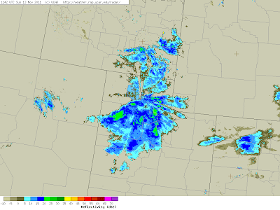
The latest regional radar image shows scattered precipitation to our north.
We're hoping that will mean we'll be a bit more unstable once the trough comes through and we'll get some mountain convection in the post-frontal environment. We'll keep our fingers crossed.
Precipitation rates at Alta have picked up nicely, with .04" and .08" of SWE from 0200-0300 and 0300-0400 MST, respectively. Snow depth sensor suggests about 2" of snow.

That would be fairly low water content snow (6%), although the accuracy of the snow-depth sensor is insufficient that we can have high confidence in that number. If, however, we're getting lots of dendritic growth with light winds, it's a possibility. We'll have to see what the ice crystal imager says.
Looking at the loop above, I see somepersistent periods of lower reflectivity over the southern Salt Lake Valley, suggesting that the Oquirrh rain shadow is still present, whereas, there is persistent enhancement on the windward side of Timpanogos. Thus, Alta is still not the hot spot.
The latest regional radar image shows scattered precipitation to our north.

We're hoping that will mean we'll be a bit more unstable once the trough comes through and we'll get some mountain convection in the post-frontal environment. We'll keep our fingers crossed.
Saturday, November 12, 2011
Shutting Down for the Night
We've opted not to move the DOW tonight. We're shutting it down for a couple of hours to sleep, but tonight's storm is expected to come in overnight and we don't want to miss it. Thus, we have a couple of students catching some shut-eye in the truck and they will get up early to fire it up once the next storm begins to move in.
The storm today (Saturday) was a bit of a bust at Alta. Looks like a 6 inch storm total at Alta-Collins with .75" of snow-water equivalent. Most of that snow fell in dribs and drabs, with the heaviest stuff coming in the late night and early morning hours on Saturday. As discussed earlier, precipitation shadowing by the Oquirrh Mountains appeared to play an important role in today's event.
Signing off for the night...
Oquirrh Precipitation Shadow
The Oquirrh Mountains appear to have had a dramatic impact on the precipitation today. Over the past two hours, we have been clearly in a precipitation shadow at the DOW site, and even the area around the Cottonwoods had weaker radar returns than the mountains just to the north. In fact, Alta-Collins only had .03" of snow water equivalent from 3-4 pm. The frontal band has simply been unable to move into the south valley with the same intensity it had to the north.
The precipitation shadow is evident in the KMTX radar image below as a west-east oriented line of low reflectivity over the south Salt Lake Valley. I'm using the KMTX image as it provides better context.

The precipitation shadow was oriented from SW-NE, but veered as the winds have shifted to westerly at crest level. Fascinating stuff. Not what we were looking for, but interesting nonetheless.
Looking at the Wasach
The storm is finally here in earnest. Nice vertical scan below of heavy snow on the western slope of the Wasatch. The mountains are the sloping bright yellow feature.


Calm Before the Storm
It's been a busy morning in the DOW, but presently we are enjoying the calm before the storm. There is a whopper of a front coming in. Post-frontal wind gusts at Hat Island reached 63 miles per hour. We're really looking forward to it!
After getting the DOW running ~730 this morning, we sampled some fairly steady snow that was falling in Little Cottonwood Canyon (LCC). The large-scale flow was out of the southwest, and a nice shallow cumulus cloud hung over the LCC-American Fork divide. Radar echoes were strongest in the upper canyon and to the east.
More recently, precipitation rates have let up. It's been doing little in the lower canyon, but still snowing lightly in the upper canyon, as shown in the picture below.

The lull has been good as we've been able to get some food and fine-tune our scanning strategies in preparation for the main event to come. We have five vertical scans at 1-degree intervals painting out Little Cottonwood, with additional vertical scans examining the front, Twin Peaks, and Lone Peak. We also have several horizontal scans painting out the Salt Lake Valley.
The radar suggests we are in for an exciting afternoon. I don't think we'll be leaving the cab once the front gets here.
Deployed and Scanning

We are now setup and deployed directly west of Little Cottonwood Canyon in the South Jordan Parkway park-and-ride lot for the Trax light rail. We have two teams here, one with the DOW and the other doing upper-air soundings. Getting comfortable for the long haul. Data coming into the DOW looks great. More later.
Weekend Storm Chasin' Begins
The Doppler on Wheels (DOW) is pulling out of the hanger early this morning for what looks to be a very exciting weekend of "storm chasing." Both meteorologists and skiers should be happy.

Thanks to the moist, southwesterly, pre-frontal flow, it's already snowing in the Wasatch Range.
Alta-Collins has had about .09" of snow-water equivalent in the past two hours. Not a lot, but it is a start. We expect precipitation rates to pick up with the approach of the front and hope to be sampling changes in the structure and intensity of the storm in the Cottonwoods throughout the day. Time to hit the road!
Subscribe to:
Comments (Atom)