Our decision to leave a crew at the DOW really paid off last night. The latest storm came in fast and they started operations at 1 am. For the past couple of hours, a broad, stratiform region of precipitation has been moving across northern Utah.
Precipitation rates at Alta have picked up nicely, with .04" and .08" of SWE from 0200-0300 and 0300-0400 MST, respectively. Snow depth sensor suggests about 2" of snow.
That would be fairly low water content snow (6%), although the accuracy of the snow-depth sensor is insufficient that we can have high confidence in that number. If, however, we're getting lots of dendritic growth with light winds, it's a possibility. We'll have to see what the ice crystal imager says.
Looking at the loop above, I see somepersistent periods of lower reflectivity over the southern Salt Lake Valley, suggesting that the Oquirrh rain shadow is still present, whereas, there is persistent enhancement on the windward side of Timpanogos. Thus, Alta is still not the hot spot.
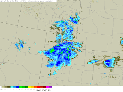
The latest regional radar image shows scattered precipitation to our north.
We're hoping that will mean we'll be a bit more unstable once the trough comes through and we'll get some mountain convection in the post-frontal environment. We'll keep our fingers crossed.


No comments:
Post a Comment