Friday, May 30, 2014

Calling Radar and Precipitation Junkies

One of the more exciting developments over the past few years in my field has been the development of applications that can integrate data from ground-based radars, space-borne radars, precipitation gauges, and other platforms to produce very detailed analyses of the three-dimensional structure of precipitation systems and the accumulation of precipitation on the ground.

One such system, which radar and precipitation junkies can access and play with at nmq.ou.edu, is the Multi-Radar Multi-Sensor System (MRMS) developed as a joint initiative between the National Severe Storms Lab, FAA, National Weather Service, and the University of Oklahoma Cooperative Institute in Mesoscale Meteorological Studies.  The MRMS allows one to examine historical (beginning July 2013) or real-time storms, which is great for both researchers and weather junkies.

Here are a few snippets from the system.  I'll concentrate on a particularly intense lake-effect storm that we examined during the National Science Foundation sponsored Ontario Winter Lake-effect Systems (OWLeS) field campaign this past winter.  An advantage of the MRMS here is the use of both US and Canadian Radars, providing a more complete view of lake-effect precipitation in the Great Lakes Region.

Source: nmq.ou.edu
The system also provides what meteorologists call quantitative precipitation estimates, or QPE, which is basically just a spatial map showing the estimated precipitation during a period of interest.  Such estimates are surprisingly difficult to produce.  Radar has the advantage of high resolution in both space and time, but for a variety of reasons, often suffers from large errors.  Gauges typically have better accuracy (but not always), but are often widely spaced.  The MRMS system blends these and other observations to produce a best-of-both-worlds analysis.  The one below is for the 24-hour period during the storm depicted above and shows nicely the highly concentrated snowbands downstream of Lakes Erie and Ontario and the enhancement of precipitation over the Tug Hill Plateau east of Lake Ontario.

Source: nmq.ou.edu
Finally, there is the ability to take vertical slices through storms - something I do frequently with some of my toys in the office, but not using multiple radars online.  Here we take a slice through three lake-effect bands showing the deeper, more intense nature of the snowband downstream of Lake Ontario over the Tug Hill Plateau and the weaker bands to the north and south that have persisted well downstream of Lakes Huron and Erie. 

Source: nmq.ou.edu
Lake-effect storms are typically quite shallow and that is definitely the case during this event.  Those of you looking to really have fun with this should target severe thunderstorms and you should have even more fun.

Thursday, May 29, 2014

Oddities about Wednesday Night's Minimum Temperature "Record"

Wednesday night was remarkably warm, with an overnight low at the Salt Lake City Airport of 74ºF, good enough for a record high minimum temperature for both the day and the month, or was it?

Source: NWS.
As noted in the NWS statement above (see the * and +) records at the Salt Lake City airport are based on the calendar day (i.e., midnight to midnight).  As such, the low temperature for the day can occur at any time during that period.  So what happened before midnight last night?  There was a cold-frontal passage just before midnight, but temperatures remained quite high, dropping to only 73ºF by midnight.  Still good for a record right?  


Nope.  The calendar day is defined using standard time and we are currently on daylight time.  Midnight standard time is actually 1 AM daylight time.  By 1 AM, the temperature fell to 67ºF and that stands as our official non-record minimum for the day.  

 
Easy come, easy go.  Even the 93ºF maximum wasn't a record.  It would have tied the record the previous day, but in 2003 we hit 99ºF on May 28th.  

Source: NWS
So, we were shut out all around, but it was still a very warm day that ends up being 16ºF warmer than average.

Wednesday, May 28, 2014

Fiery Debate about Fireworks

Source: sltrib.com
As discussed in over the weekend in the Salt Lake Tribune, Salt Lake City Mayor Ralph Becker is proposing to eliminate city support for July 4 and July 24 (Pioneer Day) fireworks at Liberty and Jordan Parks, suggesting it would be a symbolic measure for combatting poor air quality.  Not surprisingly, this has proven to be a controversial proposal, setting off fireworks with the city council.

We have discussed this issue previously, especially after this past New Years Eve when numerous fireworks displays went off despite wide-spread poor air quality.  This led to a measurable increase in PM2.5, making a bad air quality episode even worse.  Although I am less concerned with summertime fireworks when mixing is typically more vigorous, their impact on air quality has been documented and it would make sense to curtail them in situations where the air quality is degraded and we don't want to add insult to injury.

Below is a repost of the First Day Fireworks Fiasco post of January 1, 2014, which shows some of the impacts of fireworks on PM2.5.
________________________________________________________________________________

First Day Fireworks Fiasco
Reposted from January 1, 2014

The gunk remains on New Years Day
Last night the shows went on as planned with fireworks displays in downtown Salt Lake City, Provo, and Ogden and perhaps elsewhere.  I love fireworks, but last night it was totally inappropriate to have these displays.  It is well known that fireworks produce large quantities of particulate matter.  There is a view that this is only a "temporary problem," and that might be the case on the 4th of July when the atmosphere is more conducive to mixing.  Currently, however, we are in an inversion and the particulates from those fireworks are going to contribute to our long term pollution problem, like it or not.

Overnight PM2.5 concentrations show possible evidence of a fireworks pollution spike right after midnight in both Utah and Weber counties.  Hourly PM2.5 concentrations in Utah County spiked from about 30 to 50 ug/m3 after midnight.  They have settled down a bit, but remain higher than they were yesterday and are now in the unhealthy for sensitive groups category.

Source: Utah Division of Air Quality
A similar spike was observed in Weber County, which is now well into the unhealthy for all groups category.

Source: Utah Division of Air Quality
The evidence for a spike in Salt Lake County is less clear, but it needs to be noted that the sensor is at Hawthorne Elementary, which is typically upstream of downtown at night.  I suspect most of the fireworks pollution was swept over the Great Salt Lake where it will slowly mix with all the other gunk and contribute to our long term pollution woes.  

Source: Utah Division of Air Quality
Once again, we have met the enemy and it is us.  How we can allow for the use of fireworks during such conditions is beyond me.  A Salt Lake Tribune article from last 4th of July suggests that a federal regulations loophole allows it, but I suspect the spirit of that loophole is to allow for a temporary increase in pollution during periods of otherwise good air quality.  In this instance, we are mired in terrible pollution and there is no justification for letting the show go on.   

Tuesday, May 27, 2014

Hot, Dry, and Dusty

With a likely high at or perhaps just above 90ºF at the Salt Lake City airport this afternoon, I guess we can say that summer starts today.  Tomorrow looks to be a hot one as well, with stronger southerly flow and the possibility that we may see some dust blowing in from the Sevier desert and lake bed.


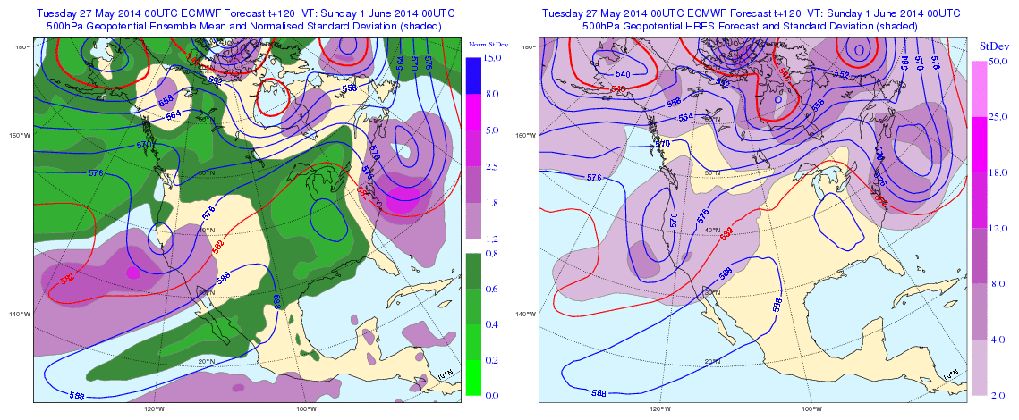
The pattern through Saturday is characterized by troughing over the west coast with Utah in warm, dry southwesterly flow, as illustrated by the ECMWF forecasts for Thursday afternoon (00UTC Friday), and Saturday afternoon (00UTC Sunday) below.


Thus, even though tomorrow (Wednesday) looks to be the warmest day of the week, above average temperatures and dry conditions are likely to persist through Saturday.  If you've been putting off sprinkler maintenance, this will be the week to get caught up.  

Saturday, May 24, 2014

Salt Lake Valley Getting the Memorial Day Weekend Shaft

A feature sometimes referred to as a deformation band has been sitting over the Salt Lake Valley all morning, spoiling the start of the Memorial Day Weekend.


Such features sometimes develop to the northeast of closed upper-level lows, as is the case today, where there is a subtle shift in the wind.  Note in the image below the slight shift in the wind from northerly or northeasterly to the northwest of the band and more easterly to the east of the band.


These bands tend to be slow moving, and that's why we've been stuck in the rain all morning.  In winter, a band like this can create all sorts of problems as the snow piles up in a narrow corridor.  Today, it's just ruining everyone's golf and picnic plans.

Friday, May 23, 2014

Snirty Dancing


My son was off school today so we decided to beat the weekend rush for first turns in the Wasatch (ha ha) and go for an early morning tour.  Thanks to this winter's dust storms and Alta preparing to improve the trails in the Corkscrew/Nina's Curve area, the base was rather unappetizing.  

Things looked only marginally better a bit further up the mountain as the impacts from this spring's dust storms are readily apparent and the snowcover is quite dirty.  What a shame. 


 The view of a a few lingering patches of "white corn" mixed in with snirt.


Despite the unappealing color, the snow is well consolidated and skied reasonably well.


The forecast hasn't changed much from my Wednesday update, except that the "pesky trough" is perhaps lingering over the state a bit longer.  Looks like some showers and thunderstorms statewide tomorrow, southern and eastern Utah on Sunday, and perhaps some lingering stuff on Monday.  Afternoon will be the most active period.  Give the hit or miss nature of these storms, keep an eye to the sky and practice common sense lightning and weather safety.

Thursday, May 22, 2014

Spring in the Rockies, Part II

It was just 10 days ago that we were talking about snow across much of the central Rocky Mountain region, including several inches in the Denver Metropolitan area (see It's Not Over Until We Say It's Over).  My how things have changed as yesterday a remarkable supercell thunderstorm moved through the Denver Metropolitan area, resulting in a tornado warning for an area that included the Denver International Airport.


Some great photos of the storm are available from thedenverchannel.com.  As of this morning, the Storm Prediction lists 9 tornado reports from the area.

The Doppler velocity image below shows the remarkable mesocyclone that accompanied the storm with green indicating flow towards the radar (lighter green indicates stronger flow towards the radar) and red indicating flow away from the radar.  A mesocyclone is a storm-scale area of strong rotation.  At this time, the counterclockwise circulation associated with the mesocyclone is centered to the immediate west of the radar (radar site in the center of the white dot), with a beautiful hook in the inbounds (green) Doppler velocities.


Significant hail accumulations were also reported in the area.  The Denver Police Department took this photo of a 5 inch hail accumulation.


The hail intensity/damage potential in eastern Colorado is amongst the highest in the United States, with $3 billion in damages during the first decade of the 21st century.  It's a good place to own a garage.

Wednesday, May 21, 2014

A Pesky Trough

A pesky upper-level trough is presently sitting over and bringing showers to Nevada.  This trough is the main fly in the ointment for the Memorial Day weekend forecast as it is expected to slowly move across the southwest United States bringing with it a chance of showers and thunderstorms.

The track, intensity, and speed of the upper-level trough has been subject to uncertainty the past few days.  Overnight runs from the North American Ensemble Forecast System (NAEFS) and ECMWF ensemble system center the trough just south of the four corners by 0000 UTC Sunday (6 PM MDT Saturday).

Source: Environment Canada
Source: ECMWF
The system is not particularly strong, but contains sufficient moisture, instability, and dynamics to bring a threat of showers and thunderstorms to the southern and eastern portions of Utah on Friday and Saturday, with a lingering threat in the far southeastern part of the state on Sunday.  Keep an eye on the forecasts and an eye to the sky.

Monday, May 19, 2014

Guestimating the End of Snow

A pretty good guess for the rate of snowmelt in a mature snowpack on north facing aspects in the Wasatch Mountains in late spring and early summer is 2–2.5 inches a day.  Obviously this changes depending on the weather and snow conditions (for instance, how dusty and dirty it is) but it works pretty well in patterns like these and is a pretty good guess for the rate of snow loss this time of year.  

The gradual demise of the snowpack at Alta-Collins can be seen in the 7-day trace of hourly snow depth measurements below.

Source: Alta–Collins
The drop over this 7 day period is from 115 to 98 inches, or an average of 2.4 inches per day.  At that rate, we have 41 days until the end of snow at this site, which would be about June 27th.

Sunday, May 18, 2014

Snirty Snowbird


What a pity. I'm going to guess, and this is purely a guess, that we have enough dust on the snow this year to accelerate the loss of snowcover by about 10 days.  We need to get a snow-energy balance station in the Wasatch so that we can collect the data needed to better quantify the impact of the dust.

Friday, May 16, 2014

Last Weekend of White Corn?

The head Wasatch Weather Weenie on a rare ski tour
It was a magical day today.

First, I got my favorite e-mail from Google.  You know, the one with the header that says: "You have no events scheduled for today."  Oh, how I love it when that happens.

Then, my back felt unusually spry once again.  I'm hoping this is a trend, but if not, I decided to go for a short ski tour just in case.  If there was 18" new, the day would have been perfect, but 2 out of 3 ain't bad.

As is often the case with spring skiing, timing is everything and we had one great run and one terrible run.  On the ascent, we were quite pleased to find the snirt to be buried and the snow white.  Any hint of yellowing in the photo below is purely an artifact of my poor photography.  The snow had frozen just enough overnight to be supportive.


Our timing was perfect for a great run on a south-facing aspect into Snake Creek where we found the turns to be surprisingly good.  Buoyed for more, we climbed back up to ski out to the car and found nothing but mank and sticky snow on the north aspect where the snow from last week had yet to corn up.  C'est la vie.  One good run given my balky back is still quite satisfying.

This weekend might provide the last opportunity to ski "white corn" this year, if you can find anything that's corned up given the warm nights.  Snirt is already starting to appear in areas where the snowfall last week was light, scoured by the wind, or is melting fast.  It won't be long and the Wasatch will be looking brown and dingy.

This southeast facing aspect holds mostly white corn, but snirt is beginning to emerge
If you do get out, be careful.  We kicked off some really large roller balls and wet sloughs on steeper terrain once things had warmed up.

Thursday, May 15, 2014

Why Climate Change is "Bad"

Over the years, some people have criticized me for emphasizing "bad" aspects of global warming rather than "good" aspects.  Since I am very concerned about global warming, this might partially reflect a personal bias.  However, even though there will be some so-called winners with climate change, negative impacts will exceed positive ones, especially if the climate change is abrupt.

Why?  Because our entire society has been built around the climate of the 20th century (and to some degree the climate of the last couple thousand years).  Where we grow crops, how we store and distribute water, where we have built cities, and how we have built infrastructure for resiliency against weather and climate variability are a function of that 20th century climate (and to some degree the climate of the preceding centuries).

Here are some examples.  Water is the agent that delivers most climate impacts and even if there are a few winners with climate change, everyone loses with sea level rise.  Most of the worlds largest urban areas sit in coastal areas. In the United States, more than 50% of the population is near coasts and approximately 3.7 million people living within 1 m elevation of mean high tide (TIDEL).

Source: Strauss et al. (2012)
The challenges in these regions are multifaceted and involve more than the direct effect of inundation by sea level rise.  Coastal erosion and wetland loss increases vulnerability to storm surges.  Saltwater intrusion intrusion into aquifers leads to contamination of drinking water sources.  Etc.

How about National Security?  The Center for Naval Analyses Military Advisory Board, comprised of retired high-level officers and generals fro the armed forces, issued a report this week entitled National Security and the Accelerating Risks of Climate Change.  Again we see here that a shift in the climate is a societal stressor:
"The projected impacts of climate change will be more than threat multipliers; they will serve as catalysts for instability and conflict."

"As the world's population and living standards continue to grow, the projected climate impacts on the nexus of water, food, and energy security become more profound. Fresh water, food, and energy are inextricably linked, and the choices made over how these finite resources will be produced, distributed, and used will have increasing security implications."

"Projected climate change impacts inside the borders of the United States will challenge key elements of our National Power and encumber our homeland security. Of particular concern are climate impacts to our military, infrastructure, economic, and social support systems."
One interesting case study discussed in the report is the impact of sea level rise on the military infrastructure in the Hampton Roads area of Virginia (p. 25), which includes 29 military sites and serves as home for 20% of the U.S. military fleet.  This is a low lying area in which significant adaptation efforts will be needed.

Source: http://www.cna.org/sites/default/files/MAB_2014.pdf
Another region discussed is the Arctic, where the loss of sea ice opens up commercial opportunities but also potential international flash points.
Source: http://www.cna.org/sites/default/files/MAB_2014.pdf
The list goes on and on.  The bottom line here is that change is hard and that's why climate change is "bad." A small shift in climate is perhaps tolerable, but that's looking increasingly unlikely.

Wednesday, May 14, 2014

Let's Be Careful Out There

I suspect there won't be many people out and about in the Wasatch Backcountry the next few days, but if you are heading out, let's be careful out there.  Conditions are ripe for wet spring slides.  Over the past week, the snowfall at upper-elevations contained about 3 inches of water, quite a dumpage for May when you consider that the monthly average precipitation for May at Alta is 3.86 inches.  

Source: Alta-Collins
Now we are going to warm it up.  Temperatures in the upper elevations will be climbing each day for the rest of the week and the nightly freeze will become weaker and weaker.  Temperatures at 11,000 feet will be solidly in the 40s by late Thursday through Saturday, and it will be much warmer than that at lower elevations.
Source: weather.utah.edu
The gradual rise is perhaps better than an abrupt shift, but still, one needs to be cautious when going from big spring dumpage to a big spring warmup.

Tuesday, May 13, 2014

The Spring Snow Rollercoaster

The ski season this spring has been quite a roller coaster. Source: http://www.telegraph.co.uk/news/newstopics/howaboutthat/5881002/Man-skates-down-roller-coaster.html
Spring is known for ups and downs, but this spring has been especially interesting as we've had fluctuations from high amplitude ridges, accompanied by several days of warm sunny weather, to cold troughs that produce significant mountain snows.  

As a result, the evolution of the snowpack in the central Wasatch this winter looks like one of those old wooden roller coasters with a long climb to great heights, followed by a series of drops and climbs. 

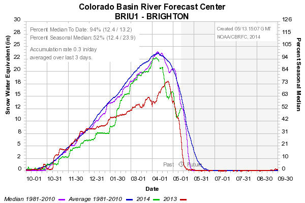
This is especially apparent at the Brighton and Thaynes Canyon (mid-mountain Park City) SNOTEL stations where peak snowpack snow-water equivalent (SWE) occurred in early April, but you can see two sharp recoveries following storms in late April and mid May (green line is this winter, red last winter, blue average, and purple median).    

Source: NWS/CBRFC
Source: NWS/CBRFC
The Snowbird SNOTEL owing to it's slightly higher elevation and more north-facing aspect has nearly held steady over the past month.  

Source: NWS/CBRFC
At Alta-Collins (~9700 ft), the snow depth is currently 115 inches, very close to the maximum that was attained in late April and about as high as it has been all winter.

Source: MesoWest
In many respects, this has been an upside down winter.  Alta reached 250 inches of snow on February 12th, which represents an accumulation over a period of about 3 months.  Since then, another 200 inches has fallen, including about 100 inches since late March.  

This is really the opposite of what you want.  It's better to have more snow early and less snow late.  But, those who have continued to venture to the mountains have found some surprisingly good skiing, and a lack of people.

Monday, May 12, 2014

It's Not Over Until We Say Its Over!


For Colorado, Utah, and Wyoming, Mother Nature is pulling a Bluto Blutarski and declaring that winter is "nothing is over until we decide it is!"  Warning, the clip above includes strong language, but also a good history lesson.

The calendar may say May 12th, but a major winter storm has just rumbled through the central Rockies. Below are some daily snowfall observations provided to the Community Collaborative Rain, Hail, & Snow Network (a.k.a., CoCoRaHS) this morning in Colorado.  Accumulations in Denver area of up 9 inches, in the front range of up to 20 inches, and near Kremmling in Grand County of up to 22 inches.

Source: CoCoRaHS
Ah, spring in the Rockies.  As Al Pacino said in the Godfather, "just when I think I'm out, they pull me back in!."  It will be interesting to see the storm totals as snow is still falling in places.

The average monthly snowfall in Denver features a peak of 11.5 inches in March, with April being the 2nd snowiest month.  So, the area is no stranger to late season storms and some of their biggest events have come in the spring.  Although their May average is only 1.7 inches, if one peruses the climate record, one can find that May snow is episodic, but over their long period of record there's on average a 1 in 7 chance of observing 5 inches of snow or more in May.

Utah of course got some too, including 9 inches in Cedar City and presumably some decent amounts in the upper elevations of central and eastern Utah, although I haven't had a chance to comb through the SNOTEL data to get some numbers (feel free to comment and add them if you take a look).  

Temperatures in the upper-elevations of the Wasatch remained quite cool yesterday and diehards will probably find some pretty good bluebird turns this morning before the sun does its damage.  

Sunday, May 11, 2014

Snowy Utah

Snow is falling in the mid and upper elevations across most of the state today.  Here's some web cam eye candy.

Alta. 5 inches new overnight.  This could be the last powder day of the
season, although perhaps the snow will hang on through tomorrow. Get on it.
Soldier Summit.
Rattlesnake Bench, I-70, San Rafael Swell.
Boulder Summit south of Torrey.
SR-14 east of Cedar City.

Saturday, May 10, 2014

That's All She Wrote?

Some good turns were had at upper elevations today
My balky back has kept me from ski touring for most of the year, but I felt unusually spry this morning so I got out to sample some of Mother Nature's late-season offerings.  I was glad I did.  For May 10th, the skiing was just fine with some heavy powder above 9500 feet and some surprisingly smooth Cascade concrete at lower elevations.  The tracks in the Baldy Main Chute above aren't mine, but show why it pays to never give up on the ski season.  Further, we've now buried the dust layer under a couple inches of water equivalent, so maybe we'll have a few days of decent "white" corn once things start to warm up.
There's a decent chance that this weekend will provide our last flirtation with freshies for the season.  A monster ridge builds in over the west next week.


Although there's always the possibility of a cold storm in late May or June, perhaps that's all she wrote for the 2013–14 powder season.  Let's hope 2014–15 is better!

Friday, May 9, 2014

Batten Down the Hatches!

A nice thunderstorm is rolling onto campus as I write this (12:15 MDT).  Here's a view as it approached from the northwest

Source: www.timecam.tv
and a recent radar image.

Source: NCAR/RAL
Thunder and lightning abound, as well as some really cool cloud interactions with the terrain (sorry, no photos).  Enjoy from indoors!