Monday, November 30, 2020

Pathetic Start to December

As "Covember" ends, it's now a lock that July to November was the driest on record in Salt Lake City with only 1.52 inches of precipitation.  It is now one of only three years with less than 2 inches of precipitation during the period, joining 1958 (1.66 inches) and 1933 (1.72 inches).  

Source: NOAA Regional Climate Centers

As far as temperature is concerned, July to November was the 5th warmest on record with an average temperature of 66.7˚F, just a shade behind 2013 (66.9˚F), 2017 (66.9˚F), 2012 (67.1˚F), and 2016 (67.3˚F).  

Source: NOAA Regional Climate Centers

Record low precipitation and excessive warmth is a bad combination and, not surprisingly, the US Drought Monitor has all but far northern Utah in exceptional or extreme drought.  


The trend continues to start December.  believe it or not, there's a cold frontal passage tonight and for that we can be grateful as it will stir up the inversion.  On the inversion, precipitation looks to be scant.  The GFS provides just light amounts in the northern mountains and Uintas.  


The downscaled SREF is actually a bit more optimistic than I am, with 8 members producing 1 to 2.5 inches.  Whoot whoot!  The remaining 18 call for an inch or less.  Sobering reality.  


The forecast beyond that is a complete disaster.  If you want some technical mumble jumble, the large-scale pattern is one characterized by a strong Pacific storm track across the western and central Pacific, with frequent ridge development and anticyclonic wave breaking over the eastern Pacific and Western United States.  For us, that means weak large-scale flow, persistent ridging, and some meandering closed lows over at least the next 8 days.  

Pathetic.

Saturday, November 28, 2020

Deflection to Weather West

I'm starting to get lots of questions again about western drought, persistent ridging, and "the blob", the anomalously warm ocean waters in the northeast Pacific Ocean.  

If this is something you are interested in, please see the Weather West blog post "New insights into the Ridiculously Resilient Ridge & North American Winter Dipole" as it should answer most of your questions.  

Wednesday, November 25, 2020

Time to Ride Again!

For outdoors time, ride is an ambiguous word.  It could me snow riding, the favorite form of recreation for most of the readers of this blog this time of year.  Or, it could mean bike riding, which is also a great activity, but perhaps not the activity of choice in late November or early December.

Unfortunately, the models continue to favor just weak systems moving through the area and forecasts that give us limited mountain snowfall for the next several days.  I'll show a couple of examples.  The GFS forecast below, valid at 1200 UTC 2 December, has a dreaded "Rex Block" parked over the western U.S.  A Rex block features an upper level ridge to the north of a closed low, sometimes referred to as a "high over low block" by those with a Northern Hemisphere bias.  

The Euro isn't much better.  For the same validation time, the ridge/trough amplitudes and positions are a bit different, but overall the pattern is fairly similar.  

As a result, the 6-10 and 8-14 day precipitation outlooks from the Climate Prediction Center are deeply disturbing.  


For skiers, brown means frown.  Thus it's time to ride (bikes) again! 

Addendum at 9:35 AM:

A quick comment that I glossed over tonight.  We might see a bit of mountain snow, maybe a few inches.  Not a game changer, although it might freshen things up a tad.

Monday, November 23, 2020

"Covember" Doldrums

November 2020.  A month better called "Covember" given the explosion of COVID cases across the country.

For Salt Lake Area skiers, the month started out with promise with over 50 inches of snow at Alta.  Since then, however, the Covember doldrums have settled in.  Yesterday I found both overcast and "undersmog" as I walked in the Avenues foothills.  This is not an uncommon scene this time of year when a weak trough and associated warm-air advection move through the area.  Such a situation increases the stability and provides just enough lift for mid-level cloud formation, but insufficient moisture and flow to generate precipitation or scour out the stable airmass over the valley.  

If you had asked me a few days ago about snow potential Thanksgiving week, I wouldn't have been excited, but I probably would have thought we'd do OK.  Two troughs were forecast to move through the area, so we'd be bound to get something.  In a case of snatching defeat from the jaws of victory, the latest models continue to bring those troughs through, but provide the Wasatch with paltry amounts of precipitation.  The GFS loop below shows the passage of the two troughs.

The SREF forecast for Alta below does a pretty good job of summarizing the suite of solutions being put forth by the various modeling systems.  Most are calling for light accumulations from both trough passages.  Of the 26 SREF members, 23 produce 3" or less from the first trough and only one produces more than 7" from both.  


Thus, unless there's a big surprise, dust on crust or dirt, depending on elevation and aspect. 


Friday, November 20, 2020

When Were the "Good Old Days"?

A lot of people ask me why it seems to be that we never get a good start to the ski season in November.  We all have memories of good starts to the ski season.  Certainly it was better in the "good old days."  But was it?

We have relatively short records of November snowfall in the Wasatch Range.  There are actually records for Silver Lake/Brighton going back to 1916, but there are a large number of missing days prior to 1942, in some intermediate years, and then again since 2000.  Thus, I'm going to use Alta Guard, which has a shorter but more continuous record of November snowfall, with only 1972/73 missing.  

A look at the November snowfall shows three fairly distinct periods (the plot below is labeled by season, so 1945/46 denotes November 1945).  Pre 1982/83, 1982/83 to 2003/04, and post 2003/04.  The middle period of from 1982/83 to 2003/04 is the fat period when there is a high frequency of heavy November snowfalls and the six largest November snowfalls on record.  The running five-year average (black line) was near or even above 100 inches during the middle of the period.  For many people, I think these are the "good old days".

But those years were not reflective of most of the record.  For the pre-1982/83 period, the five year running average was between about 45 and 70 inches.  From 1953/54 to 1963/64 it was near 50 inches.  That ten year period compares well to the 2008/09 to present period when we've been running around 50 inches.  Maybe the old days weren't really so good?  

For kicks and giggles, the red line is a linear trend line on the snowfall.  It has a very slight downward trend that I suspect is not statistically significant.  It sometimes makes sense to use linear trends, but for snowfall, which exhibits a great deal of year to year and even decade to decade variability, linear trends over such a short period of record make little sense.  The fat years in the middle were not the result of a long-term trend, but instead what meteorologists refer to as decadal-scale variability, something that is very apparent if one looks at paleoclimate records over the western United States, such as tree rings, which show slow decadal-scale variations from wet to dry periods.  Our instrumented record for the Wasatch Range is too short to identify these.  The period from 1982/83 to 2003/04 (give or take a few years at the end) is one of the wet periods. 

A critical question, however, is whether or not our recent string of poor November snowfalls reflects something new, namely human-caused climate change.  Alternatively, are the odds of poor November snowfalls increasing due to human-caused climate change?  

I don't have the time to answer that question today, but if you want some insights, see some of my older posts:

Wednesday, November 18, 2020

Windy and Insanely Warm

So far this month, Mother Nature has fulfilled half her bargain.  She's given us snow, but instead of light winds, she keeps giving us tempests.  

Crest level winds over the last 7 days in the central Wasatch show winds with gusts at or above 50 mph have predominated about half the period.  On Saturday, the ridge tops in some areas saw gusts to nearly 100 mph, whereas this morning we've seen gusts to over 70 mph.  

This is no way to maintain decent skiing.

The situation overnight and this morning is one with strong, large-scale, southwesterly flow over Utah.  The GFS analysis for 0600 UTC (11 PM MST) showed 700-mb winds of more than 50 knots over portions of western Utah (lower left panel) and a strong sea level pressure gradient and southerly flow at the surface (lower right).  


In that southwesterly flow, there's a nice orographic cloud sitting over the central Wasatch this morning.  Sadly, it does not appear to be producing any snow.


This morning's 1200 UTC (5 AM MST) sounding from the airport is, how shall I put this, absurd.  Before you take a look, let me remind you that it is November 18 when the average high temperature is 48˚F.  

The sounding shows a surface temperature of 65˚F.  There's practically no surface inversion that typically develops at night.  Instead, very strong southerly flow has kept the atmosphere "well mixed" as we say in the meteorological business.  The wind profile shows a low-level jet with a peak wind speed of 45 knots at about 800 mb.  Winds actually decrease above that level up to 700 mb.  


Since midnight, the lowest temperature recorded at the airport was 59˚F.  That just seems ridiculous, and it is.  The highest minimum temperature on record at the airport for Nov 18 is 48˚F in 1920.  

However, daily records are based on a 24-hour period, I believe from midnight to midnight standard time.  The minimum for the 24 hour period will probably not be 59˚F when we get to midnight tonight.  The models call for a weak cold front to move through later today.  Note in the HRRR forecast below for 0000 UTC (5 PM MST) the northwesterly flow over the Salt Lake Valley and Great Salt Lake Basin.  


That will probably drop our temperatures down into the low 50s or high 40s by midnight tonight.  Thus, we still have a shot at the highest minimum temperature for the day, but 59˚F is probably not going to hold.  

On the bright side, perhaps the valley single track is drying out.  

Sunday, November 15, 2020

Skis of Seasons Past

Mother Nature has given us enough to start the ski season this year in November, but we're still dealing with low tide conditions.  

I'm skiing on some classic old skis that I prefer to think of as skis of seasons past rather than rock skis.  Specifically, I'm on a pair of Kahru Jak BCs that I think I bought in 2005.

These skis were ahead of their time.  Light and lively.  124-90-113.  I think this was the first setup I had with tech bindings.  I have a friend who used to tell me if I ever wanted to sell them to give him a call, although this year he suggested they belong in a museum.  That's a bit cruel.  I skied them today and I had FUN, although I need to take a closer look at the bindings, which may finally be on their last legs.  

I've been debating whether or not to buy equipment this year.  My "new" gear is about 4 years old and has some decent mileage.  I've been concerned that it will be hard to find anything if something breaks given the run on AT gear this season.  

Saturday, November 14, 2020

Stormy, Stormy Night

What a great night to be a weather weenie.  Heavy mountain snowfall.  Valley thunder and small hail.  It doesn't get much better than that, unless we also got more post-frontal snow. 

Let's start with the northern Wasatch. In the pre-frontal environment last evening, it was absolutely lit, with high radar reflectivities developing over the upstream lowlands and extending downstream over the Wasatch Range.  

During this period, Snowbasin's Boardwalk site recorded 0.86" of water-equivalent snowfall in two hours.  I looked at their snowcam and inferred a 4"/hour snowfall rate.  Total overnight snowfall reported by the resort was 18", with 1.99" of water equivalent at the Boardwalk site.  That's great high-density base builder and just what we need in November.  

Moving to the Salt Lake Valley, the front came through with a strong convective line, lightning, and thunder (apologies for the change in radar color scale, but it's early on a Saturday morning).   

The rumblers woke me up, but a meteorologist never complains about being rousted by weather.  Pea-sized hail pelted our windows and remained on our porch this morning.


If one were to complain about this storm, it left my place with minimal accumulation as things shut-down quickly in the post-frontal environment.  C'est la vie.

Finally, moving to the central Wasatch, the Utah Avalanche Center reports 7-15 inches of snow with 0.8-1.5 inches of water.  Alta-Collins sits at 15" on the interval board and is up 8 inches in total snow depth.  The 0.96" of water recorded by the gauge is probably low due to the strong winds.  


If you're thinking of ski touring today, keep in mind that (a) Alta is now closed to uphill, (b) the UAC rates the hazard as considerable, and (c) its really windy up there.  I just took a look at observations at crest level in the central Wasatch and at one site it has been gusting over 86 mph, with a peak of 99 mph, since 11 PM yesterday.  

We'll see some mountain snowshowers today that will taper off this afternoon.  Accumulations of maybe an inch or two at best, unless a strong squall develops. 

The models have backed off on the system for tomorrow, shunting it mainly to the north.  Maybe some snow showers with light accumulations in the central Wasatch.  An inch or two if we're lucky.  Less is more likely.  

If you like wind slab and don't find enough of it today, wait until Tuesday.  With an approaching trough, the GFS is advertising increasing flow with the dreaded flags on the wind barbs at 700 mb (10,000 ft) penetrating into northern Utah by 0000 UTC 18 November (5 PM Tuesday).  


Those represent free-atmosphere winds of 50 knots or more.  Expect more wind redistribution.  

Thursday, November 12, 2020

Base and Blow Ahead

Things are looking pretty exciting for the next few days, with a moisture laden storm for Friday night with strong winds, a decent frontal passage Friday night, post-frontal instability showers Saturday, and then another system Sunday.  Did I mention it's going to be windy?

Let's talk large-scale setup for Friday night first.  At 0000 UTC 14 November (5 PM MST Friday), the GFS forecast shows a strong upper-level trough and low-level cold front approaching Utah.  Moisture is spreading into northern Utah things beginning to get going over the northern Wasatch in the pre-frontal southwesterly flow.  It's a warm storm to start, but I'm hoping we'll see snow levels at the start of the storm late Friday afternoon near or just below the base of Snowbasin (6500 feet).  


The airmass ahead of and with the front is a juicy one.  The GFS integrated vapor transport forecast shows atmospheric river conditions penetrating across California and Nevada into northern Utah.  

Source: CW3E

Such conditions, with strong cross-barrier moisture transport, should persist over the northern Wasatch for about 6 hours as the front approaches. This is a situation ripe for heavy pre-frontal and frontal snowfall at Snowbasin and on Ben Lomond Peak.  I would not be surprised to see water-equivalent precipitation rates of 0.3 inches per hour at the Ben Lomond Peak SNOTEL.  

The GFS has the surface and 700-mb front passing through northern Utah at 0900 UTC 14 November (2 AM Friday).  Note the transition from southwest to northwest flow across the northern half of the state at that time (lower right), and west-southwest to west-northwest at 700 mb (lower left).  


The time-height section below for salt Lake City summarizes the situation,  Tomorrow (red box) we'll see strengthening southerly flow and relatively mild conditions compared to the week so far.  During the afternoon, high clouds will thicken and lower.  
Things get rolling late in the afternoon or in the early evening as strong, moisture-laden southwesterly flow impinges on the Wasatch range (green box).  Snow levels should lower fairly quickly with the onset of precipitation to about 6500 or 6000 feet.  The front passes salt Lake City at around midnight to 2 AM, with heavy precipitation and snow levels falling to the valley floor.  

Post-frontal snow showers will continue in the wake of the front (blue box), especially in the mountains.  Some lake effect could occur late Friday night and Saturday morning.  After a break late Saturday/Saturday evening, we reload for another storm Saturday night and Sunday (purple box). In the interest of time, I'm going to skip discussing that storm.  You'll just have to look it up yourself. 

For the Friday night/Saturday storm, the NAM is gong for 1.19" of water and 13.5" of snow at Alta through 11 AM Saturday.  The GFS calls for .81"/10.5".  For those of you keeping score at home, this is a rare time when the NAM is more excited than the GFS.  The SREF mean for water through 18Z 14 Nov (11 AM Sat) is about .75"/14", with a range of .4" to 1.35"/6" to 22"


I'm pretty encouraged by the storm and would lean toward .6 to 1.25" of water and 8-16" of snow by 11 AM Saturday at Alta Collins.  I expect it to be a windy affair as well.  I'll be hoping that once again I underpromise and the storm overproduces.

The Utah Avalanche Center is not yet issuing avalanche ratings, but I would be on full alert if I was heading out touring this weekend, remembering that the resorts, if they continue to allow uphill skiing, are de facto backcountry.  There are lots of hazards lurking beneath the snow surface.  Our medical community is beyond stressed.  Let's not add to their burden.  

Wednesday, November 11, 2020

Snow Report

I was able to get up this morning for a quick lap on the Collins glacier to check out the snow situation.  

My ideal first tour of the year is a mild, bluebird powder day.  That's not what I found this morning.  For a while, skinning up above the Watson Shelter, it was snowing hard, the snow guns were blasting, and the wind was roaring down the mountain in my face.  I found myself skiing up with the hood of my shell up and fully zipped.  Welcome to winter!

The wind was primarily a blessing, as it smoothed things out and made for good skiing in places.  It was a curse in a few others, but one can't complain.  The snow situation is better than I expected a few days ago before the weekend storm. 

Automated observations from the Alta Collins observing site suggest 4" of low-density snow fell this morning.  The gauge measured water equivalent is almost surely too low as is often the case when there's strong wind and low-density snow, but using the gauge measurement yields a water content of just under 3%.  


There will be a few snow showers this afternoon and possibly in the early evening.  Then we have a break until late Friday night or early Saturday morning when the next front approaches.  The early part of the storm Friday night looks to be a good producer for the northern Wasatch, although everyone will be getting something.  Mean water equivalent and snowfall from the SREF for the Friday night-Saturday storm is around 0.75"/13".  As was the case for last weekend's storm, the NAEFS is more enthusiastic, with a mean of about 1.75"/24".  The GFS is around .78"/10".  

Let's keep expectations low and hope for another overproducer.  Low expectations are the key to a happy life.  

Monday, November 9, 2020

A Well-Deserved Overproducer

After months of below-average precipitation, extreme heat, coronavirus, earthquakes, and political stress, Mother Nature finally delivered an overproducer for Utah skiers. 

Observations from the Alta-Collins site were a little flaky yesterday, but total snow depth peaked at 23", which is a reasonable guess for new snow amount.  Water amounts, which include the period prior to the one presented below, were around 1.75".  

I suspect we did better than that as the Collins gauge typically exhibits undercatch and underreporting of precipitation.  The Snowbird SNOTEL is up about 2 inches since Saturday afternoon, for example.  Despite my forecast, people were out skiing, with one report to the Utah Avalanche Center as I write this early Monday morning.  

Most impressive to me was the productivity of the storm from early Sunday morning through Sunday afternoon.  There was a lot going on, so it is impossible to generalize they day meteorologically.  I will, however, cherry pick one period from yesterday morning during which things were lighting up nicely in the southwesterly flow over Mt. Timpanogos and Lone Peak.  During this period, the Salt Lake Valley was dry (that changed eventually).  


I remain encouraged by the forecast with some periods of snow possible this week and then the potential for a more significant storm next weekend.  

Keep your fingers crossed and your friends socially distanced. 

Friday, November 6, 2020

Changes Are Coming

Forget about the Presidential election.  Changes are coming to Utah weather, so start looking at forecasts instead of vote counts.  Indeed, there's plenty to hope and argue about in the forecast below.  

I'm having some software problems this morning, so apologies for the garish colors in the loop below which shows either radar or modeled precipitation and the 500-mb (upper-level) flow pattern from 1200 UTC 5 November (5 AM MST Thursday) through 0600 UTC 8 November (11 PM MST Sunday).  The pattern is one that features what we call a "digging" upper-level trough.  That's a trough that instead of moving eastward, moves equatorward and amplifies.  

Really, that's not a best-case scenario for snow in the Cottonwoods for a few reasons.  One is that the "dynamics" associated with the upper-level trough pass to our south.  Another is that the flow stays more southerly or southwesterly.  

However, this is a deep, cold, unstable trough.  Although it's not an ideal situation, it is going to give us more precipitation than we've seen around here in some time.  

In the interest of time, I'm going to summarize the situation through the weekend using a time-height section (see Forecast Tools: The Time-Height Section for more information).  The one below shows how wind (barbs), relative humidity (color fill), freezing level (blue line), and a thermodynamic quantity known as equivalent potential temperature that combines temperature and moisture (back contours) evolve over time.  By convention, time increases to the left not right.  I've identified four key periods with colored boxes.

In the first (brown box), strong southerly flow predominates with low relative humidity at low levels, high freezing levels, and high relative humidity at upper levels.  This period, which will predominate today and tonight, will be windy and mild with dangerous fire-weather conditions (the National Weather Service has issued a Red Flag Warning for this period for all of western Utah including the Salt Lake Valley).  

Tomorrow morning and early afternoon (blue box) will be a transition period with perhaps some fits and starts of precipitation at times.  Freezing levels will lower slightly, but snow levels will be fairly high., perhaps near 9000 feet at 5 AM and lowering to 8000 feet in the early afternoon.  

Precipitation will increase and temperatures will lower later in the afternoon or in the early evening as cold air moves into northern Utah (purple box).  Expect some stronger showers and there's even the chance of a thunderstorm.  Wouldn't that be exciting! 

Later Saturday night and Sunday (red box) we have a period of post-frontal instability.  Unfortunately for the Cottonwoods, the flow never comes around to northwesterly, but remains predominantly southerly to westerly.  Still they will get some snow.  

Let's look at a few numbers for Alta-Collins (9700 feet).  Through 5 PM Sunday the NAM is producing 0.67" of water and 6" of snow.  The GFS, which is typically wetter (and often too wet), is much more enthusiastic and produces 1.77" of water and 23" of snow.  I don't have precise numbers from the ECMWF, but it's around 1.2" for the same period.  

If we look at the SREF ensemble, 5 PM Sunday equates with 09/0Z in the plumes below.  The range for snowfall by that time is from light accumulations up to about 20".  That's a big range, which reflects uncertainty in the track of the upper level flow and the areas of precipitation accompanying it.  


In contrast, the NAEFS ensemble members are skewed to higher numbers.  Again, looking through 00z 09-Nov, they are putting out 0.5 to 2.5 inches of water and 9-40" of snow (I've thrown out the highest and lower members for the snow range range).  


My view of all this based on the large-scale pattern and potential for instability is that the SREF is probably too pessimistic and the NAEFS is probably too optimistic.  I would probably throw out the lowest SREF members and the highest NAEFS members and lean toward 0.5-1.0" of water and 6-12" of snow at Alta-Collins for the period ending 5 PM Sunday.  I think to do better we will need something exciting to happen, like a really strong period of precipitation as the cold air moves in or behind the front.  

Thus, I'm not expecting to be skiing this weekend.  However, if you look at the NAEFS forecast above, there are chances for more precipitation later in the forecast period and the extended beyong that is suggestive we will continue to see action.  

Keep your fingers crossed and hope that this transition to a colder pattern also delivers the goods.  

Tuesday, November 3, 2020

More Wavering on Storm Certainty

Here we are again with a potential weekend storm in the future.  Assuming the apocalypse doesn't happen in the wake of the election, will you be skiing this weekend?

Well, people are skiing now on the lower portion of the "Collins glacier", but will there be enough natural snow to ski this weekend?

My view is probably not, although we're likely to get more snow than we've seen from the disappointing storms of recent weeks.

The situation this weekend is different than those storms which passed largely to our north.  For this weekend, we are dealing with a trough that is going to "dig" into the western United States and possibly the southwest United States.  Additionally, there is a second trough that moves into the western United States behind it, leaving much of the western United States in the grips of a deep, cold, upper-level trough.  This can be seen in the GFS forecast below.  


The good news is that it's going to get cold and it is going to be unstable.  The tough part about this situation is the "dynamics" of the storm could bypass us to the south, the flow might not be optimal for enhancement in the central Wasatch, or we simply might not get a juicy piece of the flow while the trough is overhead.  

One the other hand, we could get one or more of those things.  

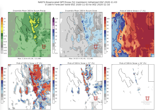
If we're talking about building a snowpack, the water equivalent of the snowfall is far more important than the snowfall amount, so let's start by looking at the the downscaled NAEFS water equivalent forecast for northern Utah through 0000 UTC 10 October (5 PM Monday).  The average water equivalent produced by the 52 NAEFS members is between 1 and 2 inches for most of the upper-elevations of the northern and central Wasatch (top left), with >70% of the members producing at least an inch (middle left).  A relatively small number of members go for more than 2 inches in the central Wasatch (lower right).  

If we convert to snowfall amount, the ensemble mean accumulations are around 18-25" in the upper elevations of the central Wasatch and more than 24" in a few places in upper Little Cottonwood and the northern Wasatch (center top).  Odds of > 24" are 30-40% in the highest elevations of the central Wasatch.  

Looking specifically at Alta Collins, 50 of the 52 members produce 0.5" of water or more for the entire period.  The bulk of the members are between 0.5 and 2" of water.  For snowfall, the range is large, with a mean of about 22 inches and most of the members falling between 10 and 30 inches.  

That sounds exciting, but the higher snow totals reflects the relatively high snow-to-liquid ratios (i.e., low density snow) our algorithm anticipates for much of the storm period (see grey region in lower right panel above).  My view is that the odds right now favor something in the 0.5 to 2.0" of water range, which is good, but not a game changer.  On the low end of that it's almost useless, on the upper end it starts to get me interested with a little help from the snowguns for a skin up Collins.  Although it is not out of the realm of possibility that we do even better, right now the models are sending too much of the dynamical part of the storm to our south.  We either need that to change or the post-frontal crap shoot to come through to give us a big orographic or lake-effect storm period.  That's not impossible, but I'm not counting on it.  

If we end up with some but not enough, don't despair.  There may be some more opportunities next week, although I don't like to place my bets on such long forecast lead times.  

Monday, November 2, 2020

25 Years at the U!

This week marks my silver anniversary at the University of Utah.  Twenty-five years ago we left Seattle Washington, drove across Snoqualmie Pass into the dry, western interior, and arrived in Salt Lake City a day later to a new home and a new life. 

The U has been a great home for me.  I was as inexperienced as they come as a new professor, having just finished my Ph.D. a few months earlier.  One has to wonder what they were thinking hiring me.  I didn't really know what I was thinking when I took the job either, but I got good vibes from John Horel, a professor in what was then the Department of Meteorology, that he would be a great mentor and indeed he has been for 25 years.  John was the best friend and mentor I could hope when I was as a young professor and and remains so as we age into obsolescence.  

There have been a lot of highlights and a few lowlights in those 25 years.  John and I contributed to weather prediction efforts for the 2002 Olympic Winter Games, John leading the development of MesoWest and observing systems at the venues, while I led the numerical weather prediction team.  As part of the effort, I attended and learned about weather support for the 1998 Nagano Winter Olympics and the 2001 Alpine World Championships in St. Anton, Austria.  

Utah Nordic legend Dave Hanscom and I at the Snow Harp Cross Country Venue,
Hakuba Valley, Japan, 1998.

I cannot tell a lie.  Skiing was involved, although there was some work too!  Following the 2002 Games, I've been able to contribute to some other Olympic forecast efforts, most recently traveling to Beijing to contribute to workshops and weather forecasting and monitoring efforts for the 2022 Winter Olympics.  


My extended forecast for those games.  Cold and windy, especially in the mountain venues, with little snow.  Heads up to journalists to pack warm if you're heading into the Beijing area mountains for outdoor events.  

I've also been able to participate in several field programs examining winter storms or mountain weather phenomenon.  In 2000, we somehow convinced NOAA to bring one of their P-3 Hurricane Hunters to Salt Lake City to fly through winter storms in the Wasatch Range.


More recently, I was able to have a homecoming of sorts to examine lake-effect storms on the Tug Hill Plateau during the OWLeS field campaign.  

Photo Credit: Ted Letcher

Of course, the best highlights of 25 years at the U are the people I've been able to work with.  This includes many great students, undergraduate and graduate, faculty, and staff, as well as friends and collaborators at the National Weather Service, especially Larry Dunn, who is now retired, but continues to question everything I do on the skin track or hiking trail.  

The job is not without its challenges.  My dream would be to do what I'm doing for a while longer, but without having to write another proposal.  If you can help, give me a call!

Sunday, November 1, 2020

November 1st Ski and Hiking Report

 November has arrived and expectations for skiing are climbing rapidly.  

There's virtually no natural snow (more on this in a minute), but the hiking right now is fantastic.  Beautiful skies, few people, ideal temperatures.  Here's a view of Mt. Superior from Flagstaff around noon today.  


As far as skiing goes, the Collins glacier doesn't go continuously yet.  The lowest 500 vertical feet or so to about 2/3 of the the way up to the angle station was being skied by some today.  Above that, there are segments of man made.  


Although proposals for improving traffic in Little Cottonwood Canyon get a great deal of attention, UDOT has been making substantial changes to their avalanche mitigation infrastructure over the past few years.  Most recently, they've been installing Wyssen Towers in many of the avalanche paths above the Town of Alta.  


Here's a closeup of one on the Flagstaff face, with the remnants of the Albion glacier in the distance.  


The Wyssen towers reduce the number of Howitzer shots that are needed in the canyon.  They can be controlled remotely and lower a charge that detonates to trigger an avalanche.  Check out the youtube video below.


I'm quite grateful to have good hiking right now as I prefer that over purgatory, which is where we would be if it was colder and there was low snow cover.  With COVID running rampant, the warmth has also been a plus as we've been able to continue dining outside with family.

Things will, however, be changing late Friday or Saturday (there are differences in timing amongst the various ensemble members) as a deep trough moves through the western US.  It's too soon to start talking details, but it does look like at a minimum it's going to feel wintery next weekend with temperatures cold enough to support snow down to the valley floors.  

Stay tuned.