Here we are again with a potential weekend storm in the future. Assuming the apocalypse doesn't happen in the wake of the election, will you be skiing this weekend?
Well, people are skiing now on the lower portion of the "Collins glacier", but will there be enough natural snow to ski this weekend?
My view is probably not, although we're likely to get more snow than we've seen from the disappointing storms of recent weeks.
The situation this weekend is different than those storms which passed largely to our north. For this weekend, we are dealing with a trough that is going to "dig" into the western United States and possibly the southwest United States. Additionally, there is a second trough that moves into the western United States behind it, leaving much of the western United States in the grips of a deep, cold, upper-level trough. This can be seen in the GFS forecast below.
The good news is that it's going to get cold and it is going to be unstable. The tough part about this situation is the "dynamics" of the storm could bypass us to the south, the flow might not be optimal for enhancement in the central Wasatch, or we simply might not get a juicy piece of the flow while the trough is overhead.
One the other hand, we could get one or more of those things.
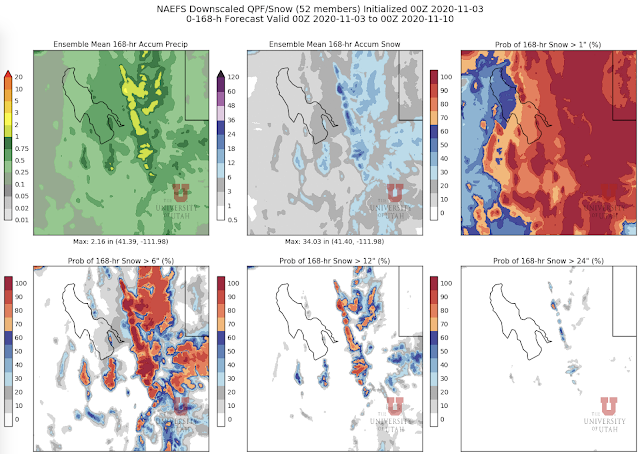
If we're talking about building a snowpack, the water equivalent of the snowfall is far more important than the snowfall amount, so let's start by looking at the the downscaled NAEFS water equivalent forecast for northern Utah through 0000 UTC 10 October (5 PM Monday). The average water equivalent produced by the 52 NAEFS members is between 1 and 2 inches for most of the upper-elevations of the northern and central Wasatch (top left), with >70% of the members producing at least an inch (middle left). A relatively small number of members go for more than 2 inches in the central Wasatch (lower right).
If we convert to snowfall amount, the ensemble mean accumulations are around 18-25" in the upper elevations of the central Wasatch and more than 24" in a few places in upper Little Cottonwood and the northern Wasatch (center top). Odds of > 24" are 30-40% in the highest elevations of the central Wasatch.
Looking specifically at Alta Collins, 50 of the 52 members produce 0.5" of water or more for the entire period. The bulk of the members are between 0.5 and 2" of water. For snowfall, the range is large, with a mean of about 22 inches and most of the members falling between 10 and 30 inches.
That sounds exciting, but the higher snow totals reflects the relatively high snow-to-liquid ratios (i.e., low density snow) our algorithm anticipates for much of the storm period (see grey region in lower right panel above). My view is that the odds right now favor something in the 0.5 to 2.0" of water range, which is good, but not a game changer. On the low end of that it's almost useless, on the upper end it starts to get me interested with a little help from the snowguns for a skin up Collins. Although it is not out of the realm of possibility that we do even better, right now the models are sending too much of the dynamical part of the storm to our south. We either need that to change or the post-frontal crap shoot to come through to give us a big orographic or lake-effect storm period. That's not impossible, but I'm not counting on it.
If we end up with some but not enough, don't despair. There may be some more opportunities next week, although I don't like to place my bets on such long forecast lead times.


Currently I am wondering if SLC will break the November monthly record high prior to this storm. Currently this seems pretty likely either Thursday or Friday, depending on cloud cover and mixing.
ReplyDelete