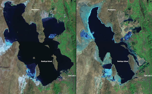
The Great Salt Lake is a terminal lake, meaning that it has no outlet. The only way for water to escape is by evaporation. As a result, its size varies during the year, from year to year, and from decade to decade depending on the amount of freshwater inflow.
 |
| Landsat satellite images of the Great Salt Lake in August 1985 and September 2010. Source: USGS Landsat Missions Gallery, "Great Salt Lake 1985–2010," US Department of Interior/USGS. |
 |
| Source: http://learn.genetics.utah.edu/content/gsl/physical_char/ |
We are currently near a historic low (see Is the Great Salt Lake Approaching a Record Low Stand?), so should we expect less lake effect this winter?
All else being equal the answer to that question might be yes. If we could, for example, have an exact repeat of the weather of any given winter, but change the the size of the lake, I suspect we would see an increase in lake effect with increasing lake size. This increase would probably be small, but it would be there nonetheless.
However, the most important factor controlling the lake effect in any given winter is the meteorology. If you get lots of cold troughs you get more frequent lake effect than in a winter dominated by warmer westerly or southwesterly flow storms.
For example, the top graph below shows the number of lake-effect events per cool season. There are large variations from year to year with as few as 3 in 2005 and as many as 20 in 2010. These variations are produced not by changes in lake size, but meteorology. This is shown in the bottom figure which shows the relationship between the number of events (bars), lake area (solid line with dots), number of trough days (solid line), and the number of days in which the lake-air temperature difference exceeded a minimum threshold for lake effect (dashed). These are expressed as standardized anomalies. Without getting into details, a large positive number indicates a greater than normal frequency and a large negative number indicates a smaller than normal frequency. There is a stronger correlation between the frequency of lake effect and the number of trough days and days that meet the minimum temperature difference threshold than the lake area. 2008 and 2010 both produced a large number of lake effect events despite the fact that the lake was very low. They were active lake-effect years because the meteorology was favorable for lake effect.
 |
| Source: Alcott et al. (2012) |
You'll note that I put frequency in italics above and there is a good reason for this. Lake-effect events can be pretty short lived and wimpy, or they can be very large. The graph below shows the amount of snow-water equivalent (SWE) produced during lake-effect periods at Snowbird during the 1998–2009 cool seasons. Half of those periods produced less than 6 mm of water equivalent, which equates to about 3 inches of snow.
 |
| Source: Yeager et al. (2013) |
Of course, this analysis is based on historical variations of the lake with an emphasis on the lake effect in any given winter. If the lake continues to shrink, we could go below a critical threshold where there is a dramatic drop off in lake effect even if the meteorology is favorable. Further, if the lake remains very low for say a decade or two, that might have a small effect on the total snowfall during that entire period. It is worth noting, however, that lake-effect periods contribute only about 5% of the total snowfall in the Cottonwoods, so it will be difficult to detect. The shrinking of the Great Salt Lake is certainly a concern for many reasons, but in the long run, the direct impacts of global warming will have a greater impact on snowfall and snowpack in the Wasatch Range than a shrinking Great Salt Lake.

This comment has been removed by the author.
ReplyDeleteIs there evidence of lake effect snow events from the much smaller Utah Lake?
ReplyDeleteYes, it happens from time to time, but is less frequent than the GSL effect.
DeleteUtah Lake typically freezes over by mid December on average which removes the possibility of lake effect which as noted does happen. Another interesting note is the high benches in southen Utah County get as much snow as Salt Lake and Davis county.
DeleteWhen the GSL is smaller it is also much more shallow, which reduces its total heat capacity by a large amount. I would think that this would also reduce the potential for lake effect, at least during the fall and early winter. In the spring, however, a very shallow lake would heat up much faster during a brief warm spell than it would with deeper water, so maybe in some situations its smaller size could contribute to lake effect (?)
ReplyDeleteIndeed, there are some complexities here that make discerning the impacts not as obvious as one might think.
DeleteThis comment has been removed by the author.
ReplyDeleteDo you think the shape of the lake would affect the direction and structure of the bands that form and come off the lake? It seems like as the coverage decreases it takes on more of a north-south orientation, so more northerly winds would be better to form the bands, which in turn affect more the west valley and Oquirrhs. At least from what I've seen the past couple of winters, the Oquirhhs and that Mountain View corridor seem to have been hit more with lake enhanced showers than the downtown to east bench areas.
ReplyDeleteThis is something that my group has discussed and speculated about for some time, although we've yet to do the research to shed insights.
Delete