Satellite imagery for the north Pacific Basin this morning is simply incredible. I could teach an entire class based on it. One can see all of the features discussed in the previous post, How to Break the Jet Stream, the amplifying ridge over the Bering Sea, the amplifying trough over the east Pacific, the explosively deepening cyclone off the northwest coast, and the developing atmospheric river to the south of the low center.
 |
| Source: College of DuPage |
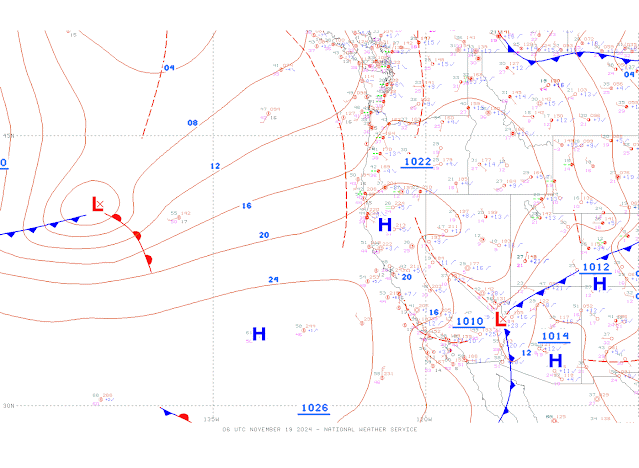
The National Weather Service Ocean Prediction Center surface analysis for 0600 UTC 19 November (11 PM MST Monday) showed the nascent cyclone upstream of the California coast. At that time it was what we call an "open wave" cyclone with a warm front, cold front, and intervening warm sector, with a central pressure of just under 1004 mb.
 |
| Source: https://ocean.weather.gov/unified_analysis.php |
However, in the satellite imager above, you can see the development of a clear comma-cloud signature overnight, an indication of rapid deepening. The GFS forecast called for the low center to deepen from what we'll call 1003 mb at the time above to an unbelievable 941 mb by 0000 UTC 20 November (5 PM MST Tuesday). I'm sitting here right now wondering if I've done something wrong. That is a drop of 62 mb in 18 hours. The weather.utah.edu products don't include the central pressure of cyclones, so I'll use the GFS forecast from Tropical tidbits for 0000 UTC 20 November (5 PM MST Tuesday) to illustrate this incredible bomb cyclone.
 |
| Source: TropicalTidbits.com |
We're fortunate that storm is a bit offshore as it means the worst of the winds will be a maritime issue (but still a threat that will alter shipping routes). However, the atmospheric river accompanying the system has its sights set on northern California and it appears it will be a long-lived AR event as we discussed in the prior post. Below is the forecast for 1800 UTC 20 Nov (11 AM MST Wednesday). The lower-left hand panel shows the magnitude of the integrated vapor transport (IVT) as colorfill and IVT vectors. IVT is a measure of the amount of water vapor passing over a square meter of the earth's surface every second. High values, indicative of an atmospheric river, extend from the eastern Pacific into northern California.
Going out another 24 hours, there isn't much change in location, although the intensity is higher.
Below is the Utah Snow Ensemble Forecast for Mt. Shasta Ski Park in the southern Cascades of northern California. There is strong agreement in the ensembles for substantial precipitation at this location with the lowest amounts for this system (i.e., through 0000 UTC 24 November) of about 5" and the highest around 11" (see upper-left diagram). I've used a red line to indicate an important transition point in the storm. Prior to that time, the wet-bulb 0.5°C level is below the site elevation and the precipitation falls as snow. In fact, there is a very tight clustering of the snowfall amounts through about 0900 UTC 21 November near about 25 inches. Through that time, the wet-bulb 0.5C level in all the ensemble members rises (lower left panel) and the snow-to-liquid ratio falls (lower right) so this will be some high density, upside down snow.

Around 0900 UTC 21 November, the wet-bulb 0.5°C level begins to rise above station elevation in somemembers and eventually it rises above station elevation inall members. The net result is that all members call for rain in the latter part of this storm period. Precipitation in the upper-left panel keeps increasing, but snowfall is flatlines and the snow-to-liquid ratio goes to zero.
The saddest five words in the English language are "the snow turned into rain." That looks to happen in this case.
Of course the more serious issues may involve flooding. There is a flood watch issued for much of northwest California, including the northern and central Sacramento Valley, mountains of southwest Shasta County, and areas to the west. Let's hope the precip numbers for this event come in lower than advertised.


That was lovely - I learned a lot. Thx
ReplyDeleteThough not great for skiing, this is a fantastic event for the Klamath River post-dam removal.
ReplyDeleteA neat aerial of the cyclone forming
ReplyDeletehttps://www.cbc.ca/polopoly_fs/1.7388340!/fileImage/httpImage/image.gif