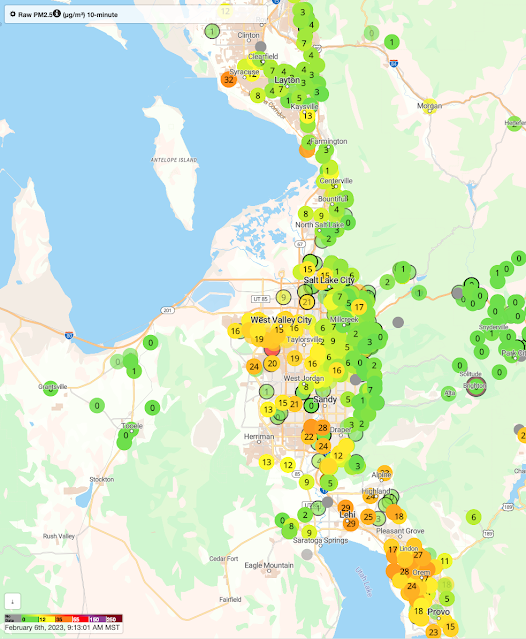
As wonderful as the snow we have had since yesterday is (14" at Alta Collins as of 8 AM), what was really fascinating about this storm is how it affected the valley cold pool and associated pollution that has been resident over the Salt Lake Valley the past few days.
The valley cold pool is the layer of cold air that resides in the Salt Lake Valley during what are known colloquially as inversions. I prefer the term cold pool because not all inversion events feature a true inversion in which temperature increases with height (the atmosphere can still be quite stable when the temperature decreases slowly with height but is not inverted). In addition, in some instances the inversion is elevated, so it is not really correct to call the cold air beneath it the inversion.
OK, enough semantics. Valley cold pools can be deep or shallow. They can mix out quickly or slowly. Then can be eroded by surface heating (which warms the cold pool) or from the top down by the wind.
Observations from Hawthorne Elementary School at 1700 South 700 East over the past several days show the buildup of pollution over the Salt Lake Valley during the last work week, with PM2.5 levels peaking at unhealthy levels on February 3rd (Friday) and 4th (Saturday).
 |
| Source: Utah Division of Air Quality |
However, on February 5th, something odd happens. First, air quality improves dramatically from about 3 AM to 9 AM when PM2.5 declines from 52 ug/m3 to 11 ug/m3. Then, it jumps up again, in just one hour, to 49 ug/m3. Talk about snatching defeat from the jaws of victory! Then there is a gradual reduction through this morning, although some pollution remains at this location. We still have not fully mixed out!
So what is going on? With the approach of the storm on Sunday, the valley cold pool scoured out in much of the valley except the northern end and near/over the Great Salt Lake and environs where elevations are lowest and the coldest of the cold air was resident. Lake temperatures are also quite low now, near 0˚C, so on a relatively warm, cloudy night, the air over the lake is locally cold. As a result, we mixed out a good portion of the valley, but as seen in the photo below, taken toward the southwest and Oquirrh Mountains from the Avenues at 7:47 AM, a thin lens of cold air and pollution remained over the northwest valley (and likely over the Great Salt Lake and environs).
 |
| Looking to the SSW from the upper Aves |
 |
| Source: purpleair.com |
Better computer models and approaches are needed to forecast such complexities than we have today. Simulating shallow cold pools is a major challenge and requires not only high resolution, but also very good information on the land surface conditions, snow cover, etc.


Hello Jim,
ReplyDeleteUnrelated to this great article: how does the amount of snow seen in Salt Lake and the benches compare to previous years? We are having quite an incredible year in the mountains and here in Millcreek I haven’t seen my full lawn since Halloween. Is Salt Lake having a deep snow year, itself?
I attempted to look at the data myself but was unable to figure out how to properly view it. I also couldn’t separate ‘snow’ and precipitation’ as in some warm years SLC gets plenty of rain but no snow. Curious what you know.
Thanks! - A Previous Student
That is a hard question to answer specifically for the Salt Lake Valley because I am unaware of any long-term snowpack measurement stations at low elevations in the valley.
DeleteThe Louis Meadow Snotel at 6700 ft in City Creek Canyon is the closest low elevation site and it has its highest snow depth in the period of record (since 2000), so I think it is safe to say that the east-bench snowpack has been fat.
Curiously, snowfall at the airport since 1 October is 38.2", which is 48 out of 139 years, so about the 34th percentile. Above median, but not exceptionally so. Perhaps at some point I can run some numbers to see how the fraction of precipitation falling as rain has effected snowfall at the airport.
Also, the valley snowpack is pretty ephemeral and dependent on sun exposure, so there is a lot of variability. Snow in my south facing yard has waxed and waned all season, as is often the case.
DeleteThank you! I was unaware there was a lack of long term snowpack measurement stations in the valley.
Delete