You can't stop Mother Nature this season. More insane numbers from the Wasatch. As reported by the Utah Avalanche Center this morning, storm totals for the PC Ridgline are now .95–1.05" water and 15–22" of snow and Upper Cottonwoods 1–2.5" of water and 16–35" of snow. The Ogden and Provo area Mountains have also been blessed with big dumps.
Snowfall late yesterday was intense at Alta-Collins. Hourly snow interval observations show an increase in snow depth from 3 to 10 inches in two hours from 5 to 7 PM. Normally the board is wiped between 4 and 5 PM, but I can't tell if that was done as the interval remained at 3 inches. Given the intense snowfall rates, it is possible it was wiped and it basically was snowing 3" an hour starting at about 4 PM.
I've heard that the Cottonwoods were a mess during this period and that the overnight road closure was moved up to 8 PM. If so, I suspect both were closely related to the heavy snowfall.
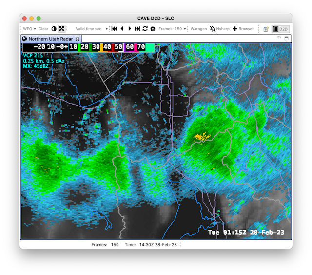
Radar observations during the period of heavy snowfall showed strong orographic enhancement of precipitation in the southern central Wasatch and Mt. Timpanogos area, with spillover to the Deer Valley Area. There was also enhancement over the southern Stansbury and Oquirrh Ranges.
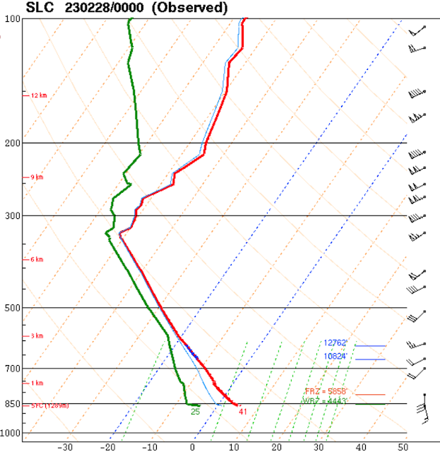
The flow during this period was southerly at valley level and southwesterly at crest level and, perhaps most importantly, the dendritic growth zone, a layer in which temperatures are between -12 and -18˚C and conducive for the formation of dendritic, low density snow, sat right at and above crest level (10824–12762 ft as identified by blue lines in the plot below).
All of these things are easy to spot in hindsight, but what separates a garden variety snowfall from an intense one is hard to identify reliably in advance. Just because the ingredients are there, doesn't mean Mother Nature will bake the cake.
Embedded in this storm was something that I don't understand. For an extended period of time, a southwest to northeast oriented band developed over the Lone Peak Massif (just north of the cursor in the loop below) and extended downstream over Little Cottonwood and upper Big Cottonwood Canyons. At ties, you can see siilar bands forming downstream of Mt. Timpanogos and even the southern Oquirrh Mountains.
I have seen such features at times before and have event posted on them previously (see
Something I Don't Understand). They have been identified in the Alps, but I am not sure if the ones we see here are a close cousin or a distant relative. Regardless, I wish we had a very detailed snowfall measurement network to identify the impact of this band on snowfall distribution in the Wasatch.
Something else is evident in the loop above and that is the cold front that came through last night with a bang. First the wind woke me up and then I saw a couple of flashes of lightning (but I heard no thunder). I've heard reports of thunder and lightning around the area, and lightningmaps.org observed many strikes along the northern Wasatch Front, two in Tooele, one in South Jordan, and four in Utah County.
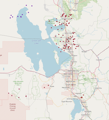 |
| Source: lightningmaps.org |
Paraphrasing Frankie Valli:
Oh, what a night
Late February back in twenty three
What a very special time for me
As I remember what a night


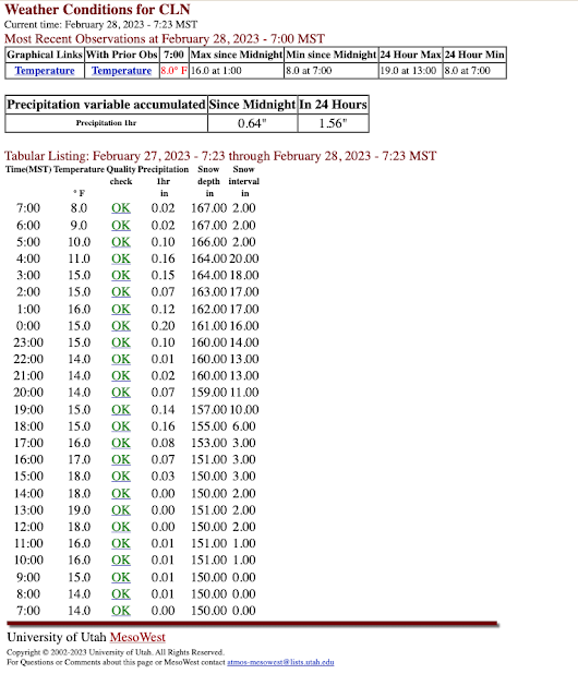
I wiped 3” off that board myself just before 16:00 so yes 3”/hr 17:00-19:00 the road was chaos
ReplyDeleteI live in the West Haven area. Intense lightning overnight, with more than 100 thunder claps in less than 10 minutes. We had almost an inch of graupel w/in the 4 inches on the car this morning. I went outside an did experience several thunder-snow sheets come down. Very cool to witness for the first time!
ReplyDeleteI plowed driveway at ~330pm. Then 5" @5pm and 5-6" @630pm. Location 8,600' Alta
ReplyDeleteWow. That would be an impressive amount of lightning in August let alone February. If we see one bolt of lightning in April here in the PNW we freak out. That boundary must have tapped into some CAPE off the lake, Anyways…we’re rooting for ya. Keep smashing those snowfall records and hopefully a rise of the GSL. Our winter has been straight up average, unremarkable, no complaints.
ReplyDeleteDo I see a Tonopah Low this morning? That would deliver the goods one more time.
ReplyDelete