It looks like this is going to be a great week for snow, skiers, and the SOLPEX field program. The latest satellite and upper air analysis valid for 1600 UTC 7 Nov shows a full-latitude, high-amplitude upper-level trough off the Pacific Coast with a great transition from deep frontal clouds to open-cellular convection across the accompanying cold front.
With some imagination, you can see old-man winter smiling at us in the vorticity analysis. That makes me happy!
The latest radar shows a great band of precipitation over northern California with good coverage downstream over central Nevada and along the Oregon-Idaho border.
That makes me happy too! We're not going to get skunked on this one.
The 12Z 7 Nov NAM brings the front in around 12Z tomorrow (8 Nov) and drags it through slowly, which is great for a prolonged period of strong synoptic forcing.
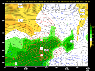
The NAM also brings in post-frontal 700-mb -11C air with a current lake temperature ~12C. Given the upstream instability, however, I expect there will be a good round of post-frontal orographic precipitation even if the lake doesn't get going. The NAM time height shows a pretty good period of steady, moist, NW flow tomorrow (Monday) night. If there is a negative, it's that the depth of the instability is fairly shallow.
It looks like we'll have a go at an IOP tomorrow night, pending a final check tomorrow morning.


No comments:
Post a Comment