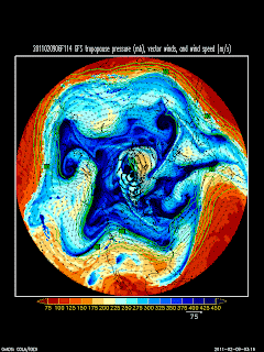
The Global Forecast System (GFS) forecast is calling for a major upper-level ridge to move over the western United States, bringing generally dry, warm, sunny weather to the Wasatch Mountains (and causing pollution to build up in the Salt Lake Valley) through the weekend.
The GFS dynamic tropopause (jet-stream level) analysis for 0600 UTC 9 Feb (11 PM MST 8 Feb) shows the high-amplitude ridge located just off the west coast with a long-wave trough over the central United States and northwesterly flow over Utah.
By 0000 UTC 11 Feb (1700 MST 11 Feb - Friday afternoon), the ridge is solidly in place over the western United States.
And it persists through the weekend, including an expansion and broadening across most of the continental United States that will bring welcome relief from the recent cold wave that has gripped the central and eastern United States.
Bottom Line for Utah Skiers: Don't forget your sunblock the next few days. This coming weekend is likely to be a real teaser for spring. Further, over the next few days backcountry skiers will find lingering powder on upper-elevation northerly aspects, but sun crusts on an increasingly wider range of aspects on the south, west, and east side of the compass. Welcome to February and the higher angle sun.


No comments:
Post a Comment