Monday, March 31, 2014

Measuring Precipitation

Measuring precipitation rates during winter storms is a remarkably difficult problem.  The basic problem is that the wind blows, and this affects the collection efficiency of traditional rain gauges, such as the one below.


The problem is that as the wind interacts with the gauge, it alters the flow in a way that some snowflakes are carried over the gauge rather than falling into it.

Source: Rasmussen et al. (2012)
The traditional way to deal with this problem is to put some sort of a shield around the gauge to reduce the airflow, such as surrounds the gauge in the picture above.  More extreme measures involve putting additional snow fences around the gauge, which is especially important in open windy areas as found, for example, across much of the high plains.  

Source: Rasmussen et al. (2011)

Even with these measures, traditional rain gauges still suffer from what is known as undercatch.  They typically measure liquid-equivalent precipitation rates that are lower than reality.  

To address this issue, John Hallet of the Desert Research Institute and Roy Rasmussen of the National Center for Environmental Prediction developed an instrument known as the Hot Plate Precipitation Sensor, sold as the TPS-3100 by Yankee Environmental Systems, Inc.  We recently took delivery of two TPS-3100s and have begun experimenting with them.  One is pictured below.  


The hot plate works in an entirely different fashion from conventional precipitation gauges.  It consists of a two hocky-puck-sized plates, placed on top of each other with one facing up and the other facing down.  These plates are kept at a constant temperature.  When precipitation falls, it acts to cool the top plate, and more energy is required to keep it at a constant temperature.  Based on the difference in energy required to keep the two plates at a constant temperature, one can infer the precipitation rate.  In addition, one can determine the precipitation rate at very high frequency.  

Several studies indicate that at least in windy, open areas, the hot plate provides more accurate precipitation measurements than conventional precipitation gauges.  On the other hand, there are times the hot plate might not do as well, such as when graupel is falling (which bounces off the sensor).  Another concern is situations in which the wind is not horizontal and the bottom or top hot plate is cooled more rapidly by ventilation.  Finally, on a clear night, for example, the top plate can cool faster than the bottom plate.  As a result, the hot plate instrument package includes sensors that can measure radiation to adjust for this effect.  

We'll be giving these hot plates a workout the next couple of months to learn their strengths and weaknesses and look forward to deploying them in the field in coming winters. 

Sunday, March 30, 2014

A Little Bit of Everything Today

We are in for a wild ride today with a little bit of everything thrown at us thanks to the passage of a spring cold front.

In the prefrontal environment this morning (about 8 am), the Salt Lake Valley and Wasatch Mountains are seeing strong south winds with dust.

A partially obscured Wasatch Range due to blowing dust
At 8 am, temperatures ahead of the front were very mild with a 62ºF reading at the Salt Lake City airport, 40ºF at the base of Alta, and 32ºF at Alta–Collins.

Things are going to change very quickly, however with the passage of the cold front, which is just upstream of Salt Lake City as I write this.  The temperature at the north end of the Great Salt Lake, for instance, is only 38ºF.

Source: MesoWest
Further, radar shows precipitation is moving in.  Some of this is evaporating before it reaches the valley floors, but valley showers and mountain snow will eventually be on the increase.
Source: NCAR/RAL
We may see some snow at bench level late in the day.  Perhaps some thunder too.  You gotta love spring.  Those going skiing today should have an interesting experience.  Dust, wind, some raindrops at low-to-mid elevations (this morning), snow, graupel, and a freeze-refreeze snow surface.

Friday, March 28, 2014

Bonus Season Event Post Mortem


Yup, the bonus season is most definitely here.   I did a short tour into a typically popular area of the Wasatch backcountry this morning and didn't see a soul.  I even had to break trail (gasp), not that it required much effort.  You could find every kind of condition imaginable out there.  I had everything from decent powder to dust-on-crust to wind board to spring mank, and that was in just one 2000 vertical foot run.  Thanks to the high angle sun and a bit of rime on the aspens, views were quite nice


If you want to become a better forecaster, going back and evaluating your predictions is essential.  In this event, Alta-Collins ended up with 15 inches of snow, which is at the bottom threshold of the 15–24 inches I went for on Wednesday.  At that time, the 12-km NAM called for 1.08 inches of water and we ended up with 1.27", which yields a mean water content of 8.5%.  There are two sources of error in snowfall forecasts.  The first is the forecast of how much water the storm will produce.  The second is the forecast of water content. I was thinking somewhere in the 1-1.5 inch range for this event, which seems reasonable, but I was also thinking lower water contents (which yields more snow), which in hindsight was probably a bit unreasonable.  It was clear that this was going to be an unstable, late season storm and with the resulting convection, it's pretty common to see quite a bit of riming.  Thus, assuming lower-density snow was probably unwise.  A good lesson learned.

Looks like more snow on Sunday, with some uncertainty regarding the start time late Saturday night or early Sunday morning.  They way things look now, Sunday might be a good day to sleep in, read the paper, and then go out once the snow has piled up for a while.

Thursday, March 27, 2014

Wait 5 Minutes

Today looks to be one of those classic spring days that epitomizes the phrase, "if you don't like the weather, wait five minutes."

A cold and unsettled airmass has settled over northern Utah this morning with nearly everyone experiencing scattered showers.


The morning sounding shows a weak cold pool at the surface, but otherwise very steep, conditionally unstable lapse rates aloft.  A little surface heating should help further destabilize this sounding and keep the shower activity going during the day.


The models suggest some warming in the upper atmosphere during the day today, but with abundant moisture and steep lapse rates at low levels, I think we're going to see some thunderstorm activity anyway.  Snow levels in the stronger cells may drop to the valley floor.  I'm still a bit surprised we haven't seen a few more flakes on the benches so far, but temperatures are about 2ºC warmer than progged by the models yesterday, so the snow level has been hanging out on the foothills.

Looks like about 8 inches since yesterday morning at Alta-Collins.  More on the way today.  A challenge in conditions like this is that there is often enough heating and sunshine between periods of snow to dampen the snow, especially at low to mid elevations.  Getting on it when the getting is good is essential, as well as seeking those high north aspects.

Wednesday, March 26, 2014

Storms in the West and East

It's a remarkable day if you are a meteorologist.  We'll talk first about the pending storm for the Wasatch. A weak surface cold front pushed into northern Utah this morning without much fanfare.  However, precipitation will eventually move in this morning and we will likely see periods of mountain snow in the cold (compared to what we've seen the past few weeks), unstable westerly and northwesterly flow through late Thursday night or Friday morning.  The system will eventually be cold enough that at times the snow level may push to the valley floor.  If you see some white, don't be surprised.

Amongst the products that we use to forecast the weather are time height sections.  They basically provide a series of profiles so that you can see the temporal evolution of the atmosphere at a given point.  It is convention for time to increase to the left in these diagrams.

The time-height section from the 0600 UTC NAM for Salt Lake City is below and shows profiles of wind (barbs), equivalent potential temperature (a.k.a., theta-e, which can be used to identify fronts and evaluate atmospheric stability), and relative humidity (shaded).  You can see the model surface-cold frontal passage between 0600 and 1200 UTC ("Z" on the plot below is shorthand for UTC, note again that time increases to the left) and then the lagging moisture, which is why the frontal passage was mainly dry.  Beginning later this morning through 12Z Friday, we have a fairly deep layer of moist (RH > 80%) westerly to northwesterly flow over us.  The theta-e lines are also oriented almost vertically, which implies very weak stability.

I don't expect it to snow constantly during this period,  There are some weak waves that ripple through the flow and pulses of moisture (note the higher RH periods) that are going to modulate precipitation rates.  In addition, surface heating may play a role (thunder is a possibility on Thursday).   Nevertheless, it should add up.  The 6Z NAM is going for 1.08" of water and 20" of snow through Friday morning in upper Little Cottonwood.   If we look at the 9Z SREF (an ensemble of model forecasts).  I'm going to go for a storm total of 15 to 24" at the Collins stake by 6 am Friday.  Keep in mind that will come in pieces.

Meanwhile, back in the east, and tremendous explosively deepening cyclone developed overnight and is affecting portions of New England this morning.


The latest observation (1353 UTC) from Nantucket shows heavy snow with sustained winds of 48 mph and gusts to 68 mph.  Surfs up!

Analyses from the Ocean Prediction Center (OPC) showed a central pressure of 1007 mb at 1200 UTC yesterday and 984 mb at 0600 UTC today (23 mb in 18 hours).  The 12 UTC analysis hasn't come out yet, but it appears from satellite imagery that the bottom pretty much fell out in that last 6-hour period and that we are probably dealing with something near 960 mb, for more than 40 mb of deepening in 24 hours.  A friend from the OPC send the beautiful image below of the storm at 1315 UTC with an overlaid lightning-strike density forecast.

Source: NOAA/NCEP/Ocean Prediction Center
What a beast.

Tuesday, March 25, 2014

Coming in the Fall: Secrets of the Greatest Snow on Earth


Over the past couple of years I've been working on the definitive weather and climate book for those seeking deep powder and passionate about snow.  The cover has just been finalized and it is now full steam ahead for release in the fall, just in time for next ski season.   If you enjoy reading this blog, you will love the book.  In addition to revealing the real reasons why Utah has the Greatest Snow on Earth (and debunking the myths), it provides a meteorological guide to weather and snow climates around the world (with insider tips on where to find the best and most reliable powder), presents a historical and present-day account of avalanches and avalanche mitigation efforts in the Wasatch Mountains, and explores the basics of weather forecasting and climate change.

Preorder on Amazon coming soon, so stay tuned.  Much thanks to everyone who contributed to the book and to the staffs at Utah State University Press and the University Press of Colorado.

Monday, March 24, 2014

The Bonus Season Is Here

April is around the corner.  The high tomorrow (Tuesday) will probably eclipse 70 at the Salt Lake City airport.  People are biking and golfing in the valley.  The tourists and locals are giving up on ski season. That's fine by me as it means fewer people to share the mountains with when the jet stream returns to Utah later this week with the first wave of moisture pushing in Wednesday morning.


Right now things look fairly active on Wednesday and Thursday, with the NAM generating 0.93 inches of water and 15 inches of snow from Wednesday morning to late Thursday in upper Little Cottonwood Canyon.

The thing about late March and April storms is that one needs to delicately balance patience and urgency.  You often need to wait until it piles up (that snow on Wednesday will be likely fall on a hard, frozen surface on most aspects, so it will take a lot to bury the bottom), but also need to get out quickly during or immediately following the storm since the sun is merciless this time of year (Hint: you might not want to wait until the weekend).

Sunday, March 23, 2014

Dust in the Snow and Sky

Dusty snow on the south facing aspects near Alta, UT
Dust deposited in the snowpack by this past week's dust storm is already starting to appear on the snowpack on south facing aspects.   As the surface snow melts, it percolates past the dust, which collects at the snow surface.  This process is particularly rapid on south facing aspects like those in upper Little Cottonwood Canyon, although even north-facing aspects eventually suffer (although for now, the dust on the north-facing aspects is buried).  Further, dust absorbs more solar radiation than pristine snow, so it accelerates the snow melt.  Yup, global warming isn't the only thing affecting the future of snow in Utah.  

Although the bulk of our dust comes in intense storms like the one last week, we sometimes have more diffuse events that can be from regional dust sources in the western U.S. or even from Asia.  I think we may have such an event underway today as one could see a dusty tint in the air.  


Perhaps someone can have a look and let me know if this hypothesis holds water or if we might be dealing with another type of visibility obscuration such as smoke or pollution. 

Saturday, March 22, 2014

Yard Sale

I have some used ski equipment available, some would be good for growing kids.  If you are interested, drop me a note: jim.steenburgh at gmail.com.

Kids Nordica "GP-TG Super" four buckle boot size 24.0-24.5. $25. 
Teen Nordica Ace of Spades boot size 26-26.5. $40. 
Dynastar Troubled Youth twin tip skis with bindings.  138 cm.
Minor base scratches and need wax.  Good as new with a stone grind. $40. 
Dynastar Legend 8000 184 cm with bindings.  Minor
base scratches. Good as new with a stone grind. $40.

Thursday, March 20, 2014

Flies in the Ointment This Weekend

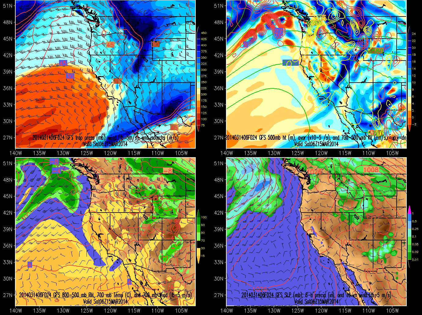
Last Friday we discussed how short-wave troughs can sometimes cause forecast problems in long-range forecasts (see Short-Wave Mischief in the Medium Range Forecast).  Today we'll discuss how they can serve as flies in the ointment of short-range forecasts (3 days or less).

The forecasts from yesterday (Wednesday) morning called for a short-wave trough to skirt us just to the north, with cooler, drier air moving into northern utah on Saturday morning.  Precipitation in northern Utah was very limited, with only a very small are of light precipitation on the north slope of the Uinta Mountains in the NAM.


Overnight, however, we see a subtle change in the characteristics of the large-scale forecast with a weak, but still significant extension of the trough extending west-southwestward into northern Nevada.  This leads to more humidity over the state (compare lower left panels) and a band of precipitation over the Uinta Basin.


The net impact of such a shift is an increase in the forecast cloud cover over northern Utah and an increase in the possibility of precipitation over the northern part of the state, perhaps mainly in that area near the band.

As forecasts shifts go, this is a minor one for most day-to-day activities, but I'm desperate for material, so give me props for the effort!  In addition, when we start thinking about the management of power generated by alternative energy sources, such as solar, subtle changes in the forecasts can be very significant.  Those thin cirrus clouds that most of us hardly notice for our day-to-day activities can dramatically reduce solar energy production and are damn tough to forecast.  

Wednesday, March 19, 2014

Global Warming Hasn't Stopped


Much has been made recently in media reports of the so-called "global warming pause" or "hiatus", a slowdown in the rate of increase of mean global surface temperatures over the past 10–15 years, as can be inferred from the graph below.  


Although the causes of this slowdown are still being worked out, when one looks at the Earth's climate system as a whole, it is pretty clear that global warming is continuing unabated.

Global warming affects not just the atmosphere, but also the hydrosphere (i.e., the oceans), the cryosphere (i.e., snow and ice), and the lithosphere (the Earth's crust).  The accumulation of energy produced by global warming thus can be expressed not only as a warming of the atmosphere, but also in terms of a warming of the oceans, melting of ice, or warming of the land surface.

A nice plot showing this energy accumulation is provided in the IPCC Fifth Assessment Report (AR5). The energy accumulation is dominated by deep and upper ocean warming.  The melting of ice and warming of the land surface are much smaller contributors, and the atmosphere even smaller.
Source: IPCC AR5
When one takes this holistic view, it is pretty clear that although the rate of atmospheric surface temperature increase has slowed during the past 10–15 years, we are still seeing a massive accumulation of energy within the Earth's climate system.  Thus, although the causes of the slowdown in surface temperature increase are still being ferreted out (see this Scientific American article for a summary), there is every reason to expect that the upward trend will eventually return.   At this point, we can't stop global warming, we can only hope to contain it.

Tuesday, March 18, 2014

Dust = Bad Snow and Bad Air

Yesterday's strong westerly and northwest winds ushered in the first major blowing dust event of the spring.  Here's a look at the dust accompanying the rather ill-defined cold front pushing into the Salt Lake Valley (courtesy George Wilkerson and Steve Krueger).


We will see that dust again later this spring.  It's been deposited now in the mountain snowpack and will rise to the top, along with other impurities, as the snowpack melts.  Because dust is darker than pristine snow, it absorbs more sunlight, and thus it's presence accelerates the snowmelt in the spring.  

The dust also degrades air quality.  Note the spike in hourly PM2.5 concentrations to 33.5 ug/m3 yesterday morning.  Ick.

Source: Utah Division of Air Quality
Although many believe that these dust storms are natural events, they clearly have a strong human-caused component.  The bulk of the evidence suggests that the western U.S. is a far dustier place today than it was prior to western settlement (although not as dusty as it was prior to the passage and implementation of the Taylor Grazing Act).  Most desert surfaces are very resistant to dust emissions unless they are disturbed, and many areas of the west are highly disturbed.  Thus, I view these dust storms as unnatural events, or at least human enhanced, as many dust sources are the result of land-surface disturbance.

Monday, March 17, 2014

Our First Spring Trough


Although we have had a number of spring-like storms over the past few weeks in terms of warmth, high snow levels, and valley rains, I'll call today's event the first "spring trough" of the season.

Short-wave troughs like the one approaching us this morning (see above) are a dime a dozen, but they pack a stronger meteorological punch in spring rather than winter.  The reason for this is surface heating, which is stronger in the spring and creates a less stable lower atmosphere, allowing for stronger coupling with systems aloft.  This is why we see stronger surface cyclones and cold-frontal passages in spring rather than winter.  Further, the strong winds accompanying these systems can frequently lead to dust storms that can lead to poor visibility and air quality in lowland regions and darken the snowpack in mountain regions.

Today's system has a lot going for it.  It's a fairly strong short-wave trough with a monsterous 700-mb temperature contrast of 20ºC from central Utah to western Washington (see lower left).  It also has a strong post-frontal pressure gradient and winds.


The only thing it is lacking is timing.  The most dramatic spring cold frontal passages typically occur in the afternoon or evening, so that the pre-frontal environment can warm during the day.  Instead, we're going to see the cold air pushing in this morning.  Nevertheless, it is going to be an impressive event. Strong winds and colder air will be moving in this morning (The National Weather Service has issued a high-wind warning for Salt Lake City and many other areas of northwest Utah - see http://www.wrh.noaa.gov/slc/ for further information).  Expect "lake stink" this morning and then some snow this afternoon with up to an inch in the valley.  Yesterday's sunny skies with a high of 67ºF will seem like a distant memory today.  Those of you who didn't check the forecast and wore shorts today are in for a fun afternoon...

Sunday, March 16, 2014

Sun Returns to the Steep North Aspects

Alf's High Rustler, 16 March 2014
It's a sure sign of spring when sun returns to the steep north-facing terrain of the Wasatch Range, such as Alf's High Rustler above.  For about a 4 month period centered on the winter solstice, the sun is too low in the sky to touch these aspects.  That's not the case anymore.

For a (nearly) north facing aspect like upper High Rustler, with a pitch to the cat track of about 35 degrees, the first day of potential sun is about Feb 11th, and that's only at solar noon.  Note that right at the top it is close to 45 degrees, so the first sun there is even later (note how it is in the shade in the photo above, which was taken about 90 minutes prior to solar noon).  

Today, March 16th, a north facing aspect needs to have a pitch of about 47 degrees to totally avoid the sun (there are some exceptions, such as when there is even steeper terrain adjacent and to the south).  A run like High Rustler gets sun for a few hours, enabling for some nice light for turns and shadow skiing (for those who enjoy an ego stroke).  Of course, the sun is more indirect than on other aspects, so the snow still keeps longer on these aspects than on others.  

Friday, March 14, 2014

Short-Wave Mischief in the Medium Range Forecast

As a follower of this blog, you are undoubtably aware of declining forecast skill with increasing lead time.  Extended range forecasts are generally less reliable than long range forecasts.  In extended range forecasts, sometimes the models do pretty well with regards to the big picture, but smaller-scale weather features that are inherently less predictable derail the forecast.

Case in point is my blog post from Monday, "Spring Break Guilty Pleasures," in which I wrote:
How about a few days of mountain biking, river running, hiking, canyoneering, or rock climbing in the canyonlands of southern Utah? No problemo. Head south later this week for an extended three day weekend. A huge ridge is building in and by Sunday it is parked over St. George. Oooh, I can feel and see those red, sunburned winter bodies already.
That forecast isn't terrible as yes a ridge is building in and I expect to see some sunburns on Monday, but the weather on Saturday doesn't look quite as nice as I would have anticipated on Monday.  As shown in the 114 hour GFS forecast valid midnight tonight, the ridge was forecast to dominate the weather over Utah with only a weak short-wave trough over western Montana.  As a result, dry weather and no significant weather systems were forecast over Utah.


In the latest model runs, there's still a ridge, but the short-wave trough is much stronger and extends down into the Great Basin.  As a result, cooler air moves into the state later today and tonight with some light precipitation over northern Utah.


Thus, things will be cooler tomorrow than I anticipated on Monday.  As forecasts busts go, this isn't a big one, but it shows how a smaller scale weather feature can derail a forecast that is otherwise fairly good with regards to larger-scale weather features.  It also illustrates why ensemble forecast systems can be important to consult to get a handle on the forecast uncertainty, although in this instance, I don't recall any members suggesting such a strong short-wave trough moving over and through the ridge.  Perhaps one of you out there with a subscription that allows access to the ECMWF ensemble modeling system can comment on whether or not the gold-standard of weather forecasting provided helpful guidance in its forecasts on Monday.

Thursday, March 13, 2014

Temperatures during Northern Hemisphere Winter 2013/14

The Northern Hemisphere's meteorological winter (Dec–Feb) is now in the bag.  The National Climatic Data Center served up its data for February today, allowing us to take a look at what winter brought the United States and Utah.

On a national scale, temperatures were well below average in the upper midwest (aren't winters in Minnesota nasty enough already!) and below average across most of the US east of the Rockies except near the coast where temperatures were near average.  In our part of the world, we ended up near or just above average.  In the valleys of northern Utah, that largely reflects below average temperatures in December, near average in January, and above average in February.

Source: NCDC

The image below shows the rank of this past winter relative to all 118 years since 1895.  A good swath of the upper midwest observed a top-10 coldest winter.  On the other hand, most of California basked in record warmth.  Flights from Minneapolis to SoCal were likely in high demand.

Source: NCDC
These temperatures largely reflect a large-scale 500-mb (upper-level) pattern that featured strong ridging over the northeast Pacific Ocean and a deep trough over most of eastern Canada and the eastern U.S.
Source: ESRL
Compared to climatology, this pattern features anomalously high 500-mb heights over most of the arctic extending down over the northeast Pacific and anomalously low 500-mb heights from north-central North America across the north Atlantic to western Europe.

Such a pattern essentially opens up the eastern U.S. to air originating over the high latitudes, resulting in a remarkably cold winter.  Over and east of "the pond", however, the pattern favored a strong and active Atlantic storm track that brought record rains to the UK.  

The global numbers for February haven't been released yet, but January was the fourth warmest and December the third warmest since 1880, so it is likely that this Dec–Feb period will rate near or in the top 5 warmest on record.  The fact that the globally averaged temperature was so high, yet much of the upper midwest was quite cold, illustrates the power of the large-scale circulation to have a strong impact on local and regional temperatures.

Addendum: 14 Mar 2014:

A day after writing this post, the global temperature rankings came out and the Dec–Feb period was only the 11th warmest on record.  Warm, but not in the top–5 as I suspected above.  Nevertheless the global temperature was 0.97ºF above the 20th century average, so this past winter still provides a good example of how you can get a strong regional cold anomaly even in a warming climate.  

Tuesday, March 11, 2014

Perspectives on Winter

Weird white stuff on the U grass this morning
Old man winter has returned to the Salt Lake Valley this morning, providing just enough snow to aesthetically coat the grass without wreaking havoc on the commute or, more importantly, my bus route.  

Meanwhile, the storm has produced 9 inches as of 7 am at Alta-Collins.  It's another high-density dump overall, but should be right-side-up and ski well.  Enjoy.  

Finally, in other news, check out this avalanche that took out the High Campbell chair at Crystal Mountain, Washington.  Whoa. 
Source: Crystal Mountain Facebook Page
I have a lot of good memories from riding that chair.  Looks like a new one will be ordered this summer.  So sad to see the demise of another classic fixed grip double.  At least it went out in style.  

Monday, March 10, 2014

Spring Break Guilty Pleasures

It is spring break this week at the University of Utah and the forecast suggests that students and faculty will have every opportunity to take full advantage of the embarrassment of riches found in Utah.

Want powder skiing?  How about a winter storm tonight and tomorrow for the Wasatch Range?  Looks like 6-12 inches for the upper Cottonowoods through 6 PM tomorrow. 


Tired of winter?  How about a few days of mountain biking, river running, hiking, canyoneering, or rock climbing in the canyonlands of southern Utah?  No problemo.  Head south later this week for an extended three day weekend.  A huge ridge is building in and by Sunday it is parked over St. George. Oooh, I can feel and see those red, sunburned winter bodies already.


Want to party?  Ha ha.  Can't help you there.  

Saturday, March 8, 2014

The Wasatch's Most Remarkable Microclimate

If you think that Little Cottonwood Canyon has the most remarkable microclimate in the Wasatch, think again.  Yeah, it snows a lot in upper Little Cottonwood, but if you want to find the snowiest place in the Wasatch for a given altitude, you need to venture north to the Ogden Valley.

Utah's Ogden Valley from the Trapper's Loop Highway
In particular, you need to venture to Liberty, UT and up the North Fork of the Ogden River.  Here, at low elevations, you will find ridiculous amounts of snow that has been generated and carried over the formidable terrain near Ben Lomond Peak (the thumbnail below is North Fork Park, discussed below).


By nearly all measures, this has been a terrible low-elevation snow year in the Wasatch, yet today you can find good cover and great cross country skiing at 5600–6000 ft at North Fork Park where Ogden Nordic, a chapter of The Utah Nordic Alliance (TUNA), maintains a a marvelous system of trails.  

Yeah, it's bee a bad snow year, but plenty of snow @ 5600 ft at North Fork Park.  Ben Lomond Peak in the distance.
Currently, there's essentially no snow at comparable elevations at Mountain Dell and in the Cottonwoods, but you'll find plenty of cover and great spring skiing in the North Fork area for the low-low price of $6.  What a steal!


How about some hard numbers.  The Ben Lomond Trail Snotel operates at 6000 ft in the North Fork area.  Although it is running below average, it still has about 15 inches of snow water equivalent in the snowpack.  

The snowdepth measured by the site is 44 inches.  That seemed pretty high to me, but it is safe to say that the North Fork area has the healthiest low-elevation snowpack in the Wasatch nearly every year.    

In addition to snow, there are a few other reasons to visit the area.  My son was too young to gain admission to the famed Shooting Star Saloon in Huntsville, but Carlos and Harley's in Eden is a colorful joint (site of the former Eden General Store) that served up enough Mexican food for us to replenish our depleted calories.  Warning: Consuming large quantities of Mexican food after cross country skiing results in extreme drowsiness on the return trip to Salt Lake.  

Friday, March 7, 2014

Mesoscale Vortex

Those with keen eyes may have noticed a nifty little hook in the cloud pattern over the lake in the previous post.

Turns out there was what is known as a mesoscale vortex over the lake this morning.  You can see it in the loop below.  Note how it drifts southward across the SW corner of the lake.


How about a high res MODIS image?  At this time, the center of the hook, which almost forms an eye, was sitting over the far SW corner of the lake.

Source: NASA
This lake-effect stuff is sure complicated.  I'm not sure if this vortex was lake induced or something in the larger-scale flow that just happened to be passing over the lake.