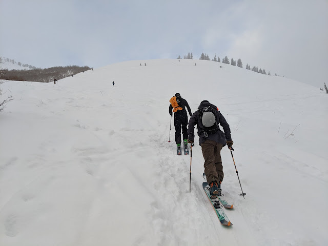
Mother Nature has been generous so far this year with 50" of snow so far at Alta and the Snowbird SNOTEL station up to a very solid 5" of snowpack water equivalent. Skiing conditions yesterday were very good. A few people elected to get out.
Most of the snow we've received so far this season has been produced by slow moving or stalled cold fronts or cold, postfrontal flows. That will change with our next system.
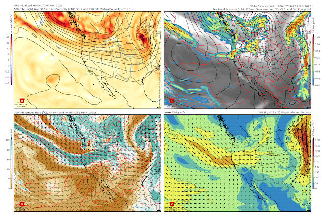
Below is the GFS forecast valid 1800 UTC 5 November (1200 MDT Saturday). Strong west-northwesterly upper-level flow extends from the eastern Pacific across the Pacific Northwest to northern Utah (upper left panel). Strong (by interior western US standards) water vapor transport extends inland across the northern Great Basin into northern Utah (lower right) with moist, westerly flow at crest level (lower left). 700-mb temperatures (lower left) are fairly mild and near -3.5˚C. Forecast precipitation along a weak surface trough that will sag through northern Utah Saturday night extends across southern Idaho.
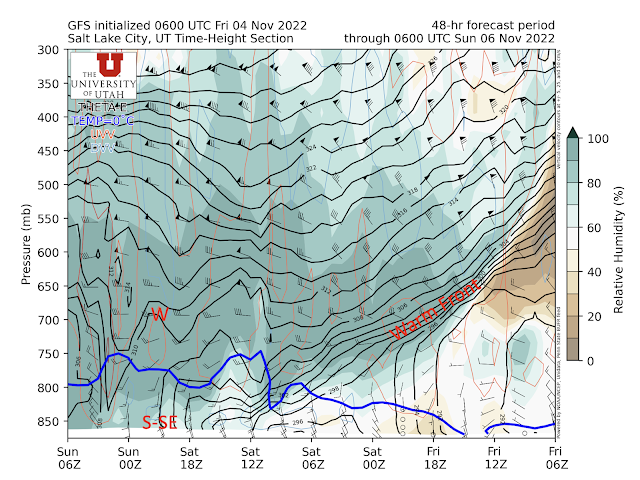
The time height section through 6Z 6 November (midnight Sunday) shows the gradual descent of an elevated warm front today through tonight. By 1200 UTC 5 November (6 AM MDT Saturday), relative humidities except near the surface are generally at or above 90% through a deep layer. During the day tomorrow, the valley flow will be southerly to southeasterly, but westerly aloft. Eventually low-level winds shift to northwesterly after 0000 UTC 6 Nov (6 PM MDT Saturday) as the GFS sags the trough slowly southward through northern Utah.
Basically, this is a recipe for a warm, windy storm in the mountains and virga with occasional rain showers in the Salt Lake Valley Saturday and Saturday night, with precipitation rates likely greatest during the approach and passage of the trough.
There are, however, model disagreements on the timing and productivity of the storm. The 12Z HRRR is going off and shows strong enhancement of water-equivalent precipitation over the Wasatch through 1200 UTC 6 November (5 AM MST Sunday - note local time change) with 0.69" at KSLC, 0.73" at Cottonwood Heights, and 2.71" at Alta-Collins. Some big numbers are also evident in the northern and southern Wasatch. Most of this precipitation falls Saturday and Saturday night.


What do you make of the Tuesday storm where GFS has Collins cum snow increasing from 12 inches Tuesday 2am to 43 inches Thursday 2am—30 inches in 48 hours. Wetbulbzero falling to valley floor Tuesday 6am. Mean of the NAEFS plume has 4 inches in Salt Lake City which could begin to bring lower elevation in. The U looks like 7 inches. If this verifies we will all be VERY HAPPY
ReplyDeleteYeah, that would be a game changer as we would have a hell of an early November snowpack if it verifies.
DeleteThere is still quite a bit of scatter in the various models and ensembles for that storm. We're dealing with a digging trough on the west coast and a lot will depend on its amplitude and track, as well as the position of the front that may develop over the Great Basin. If you look at the NAEFS, for example, there are some members that are flatlined (little to no precip) during that period, whereas others are generating a substantial amount of water and snow.
I'm not picking a winner yet and I'm living by my motto (the key to a happy life is low expectations).
GFS has the initial phase of the storm warmer than a couple days ago. Wetbulbzero 8200 feet Tuesday 6am. Scuttle was you were in the Catherines area today (Sunday), did you notice the rime/rain event around 1pm (mountain standard). I would say it was drizzling at 10,500 feet. Seems like rain/snow line was a lot higher yesterday than GFS advertised. Tempted to believe climate change is happening now but we are in early November so higher rain is to be expected. Timing of when the flow changes from south to west northwest seems to be important in wetbulbzero. Feel free to offer comforting analysis of how the storm will be cold and snow will fall at low elevation.
ReplyDeleteYes, I was in the vicinity and experience the rime/drizzle. Rime/drizzle can happen at temperatures below freezing, as was the case today. It is a myth that water freezes at "freezing." May do a post on this.
Delete