So much talk about a red or blue wave last night, when it was really a great white wave that won. The numbers from Alta are very impressive and means a climatologically deep early season snowpack will control upper elevations of the central Wasatch for the next few weeks.
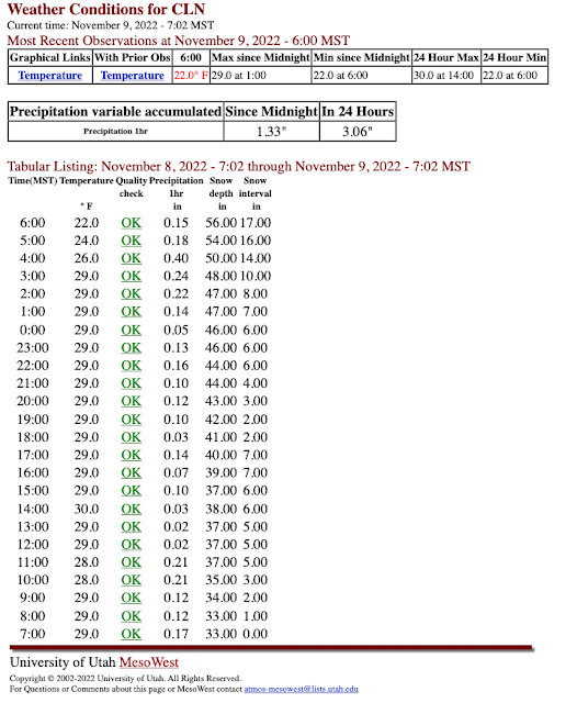
Let's talk some numbers. The storm-total SWE and snowfall at Alta-Collins (so far) are 3.38" and 24" respectively. The 24-hour and 12-hour SWE for the period ending at 6 AM this morning was 3.06" and the 12-h total for the period ending at 6 AM were 3.06" and 1.99". These are big water totals at the upper ends of what happens at Alta during the winter.
Observations from the last 24 hours also show a peak hourly SWE of 0.40" (I consider anything above 0.30" to be exceptionally heavy snowfall), which was accompanied by a 4" increase in snow depth on the interval board, and .86" in 3 hours.
 |
| Source: MesoWest |
This snow was mostly high-density base builder. The mean water content of the storm so far is about 15%. Temperatures did not decline below 29˚F at Alta-Collins until after 3 AM, so I suspect nearly the entire period featured Cascade Concrete.
Total snow depth at Alta Collins is currently 56". This is probably the 2nd most on this date in at least 30 years. On November 9, 2004, the snow depth at Alta Collins was 59". That year was the best early snowpack since 1990 at the Snowbird SNOTEL site (more on this below).
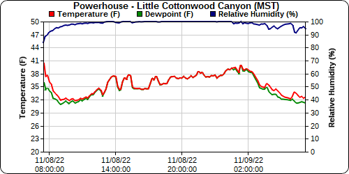
It's harder to tell how the low and mid elevations fared. Yesterday's cold front stalled between Salt Lake and Park City. Some of the cold air bled into the Cottonwoods for a while yesterday to help keep snow levels lower than I expected, but on the Park City side it remained warm. For example, at the Powerhouse observing site in lower Little Cottonwood Canyon (6049 ft), temperatures dropped to 32˚F early yesterday morning with the passage of the front and onset of precipitation, but slowly climbed through 1 AM this morning. I suspect this site saw rain or mixed rain and snow yesterday afternoon through 1 AM, but a change over to snow this morning.
 |
| Source: MesoWest |
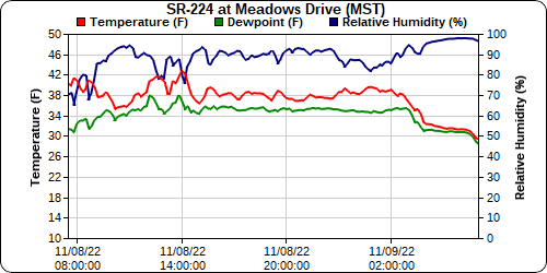
In contrast, the yesterday's cold front never made it to Park City. Thus, temperatures at the UDOT SR-224 observing site, which at 6697 feet is several hundred feet higher than the Powerhouse site in Little Cottonwood, were near or above 38˚F for most of yesterday and last night, only dropping to 32˚F after about 3 AM this morning.
 |
| Source: MesoWest |
Thus, I suspect this was mainly a rain event below about 8000 feet on the Wasatch Back, although the totals at upper elevations even on the Park City Ridgeline should be pretty solid.
Finally, we have the SNOTEL data from Snowbird. As of midnight last night, the snowpack water equivalent was 9 inches. This is the 2nd highest since 1990, behind only November 9, 2004 when it was 12.1 inches.
 |
| Source: NRCS |
The bottom line is that no matter how the election count turns out, we remain a deeply divided country. However, the white wave has taken over the central Wasatch and we have the 2nd best early season snowpack since 1990. So, regardless of where you fall on the political spectrum, there are good reasons to celebrate. What an amazing start to the ski season!

Bless your soul for promoting the good in the world! (the white wave). Happy turns
ReplyDeleteAgreed! I love this post! I'm hoping for many more white waves this season.
DeleteAt 6600 in the Wasatch back (SR248&US40). Rained ALL day yesterday and completely wiped out existing snowpack. Woke this morning to 3-4 inches of heavy wet snow.
ReplyDelete