This is a gut-check forecast if ever there was one. The models are producing a narrow band of heavy precipitation behind the surface front. The 1800 UTC NAM dumps out more than 0.75" of liquid precipitation in areas along the band by 1200 UTC (0500 am) tomorrow. Snow levels will be flirting with the benches soon.
 |
| 1800 UTC NAM accumulated precipitation (inches following scale at top) from 1800 UTC 6 Mar – 1200 UTC 7 Mar 2012 |
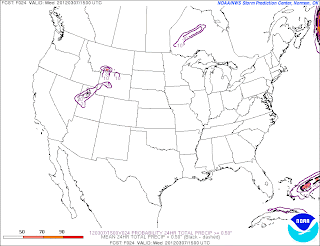
The precipitation band, however, is quite narrow and any error in position or movement has major ramifications. One way to measure the forecast uncertainty is to run lots of different forecast models and see how many produce large precipitation accumulations. The Short Range Ensemble Forecast (SREF) system run by the National Centers for Environmental Prediction includes 21 model forecasts which, when added to the NAM forecast, enables us to look at 22 different model forecasts. The plot below shows the percentage of those forecasts that produce at least 0.5" of liquid precipitation from 1500 UTC (0800 MST) 6 March to 1500 UTC (0800 MST) 7 March.
 |
| Percent of SREF members producing at least 0.5" of liquid precipitation from 1500 UTC 6 Mar – 1500 7 Mar 2012 Source: SPC |
About 50% of the ensemble members go for at least 0.5" of precipitation immediately south of the Great Salt Lake (such as the NAM forecast above), while only 10% go for at least that much in a band that extends across northern Utah. Many of these forecasts include a band of precipitation, but there is variability in the intensity, position, and movement, which results in low probabilities of > 0.5". In other words, there will be precipitation, but where, when, and how much is a very difficult forecast. And that's before we even begin to talk about snow accumulations. Snow levels will be flirting with the benches and valley floors through midnight and small changes in temperature could have a big impact on accumulations beneath the band.


No comments:
Post a Comment