
We begin with a quick look back at the past so we can put the forecast into proper perspective. You might recall that the season started out with 12 inches on the 9th and 30.5" of snow for October at Alta, which is probably fairly close to average. Since then, things have quieted down, with only 12.5 inches of snow falling so far in November. Variable snow conditions exist, with no snow on sun exposed slopes, even at upper elevations, and rotten, faceted snow on upper-elevation north aspects. The photo below, from Trent Meisenheimer's most recent Utah Avalanche Center report, shows a snowpack in Martha Bowl that "was completely faceted and rotten to the ground."

That should cause a shiver to go up the spines of backcountry skiers. On the plus side, the cold weather has allowed the resorts to make snow and several will probably be open with limited terrain this weekend.
Through Wednesday, the forecast continues to look dry and pleasant, albeit with some smog in the valley. Pre-thanksgiving mountain biking looks quite nice tomorrow afternoon as the ridge exits, the next storm makes landfall in California, and the pre-frontal southerly flow begins to increase. This might allow temperatures on the benches to rise into the 50s. There also doesn't look to be any major weather concerns statewide tomorrow.

That changes on Thanksgiving, with a trough bringing precipitation pretty much statewide. Current forecasts show snow levels dropping Thanksgiving morning and flirting with the benches and valley floors by afternoon. It will be worth keeping an eye on forecasts if you are traveling.

Then, a more powerful trough approaches from the northwest. This leads to a period of strong, moist, westerly flow Friday and Friday night, with a frontal passage currently projected for Salt Lake City late Friday night/early Saturday morning. It's probably easiest to show this in a time-height section (see below). Remember that time increases to the left. This shows the deep, dry airmass presently resident over Salt Lake City persisting through tomorrow afternoon, the trough passage Thanksgiving followed by a quick break, then the moist westerlies, and the frontal passage.

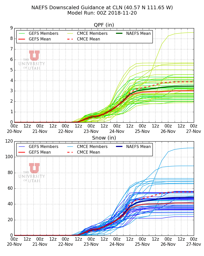
Our downscaled NAEFS forecast for Alta shows a range through 0000 UTC 25 November (5 PM MST Saturday) of about 1.8 to 5.5 inches of water and 21 to 70 inches of snow (note that I'm not discussing the last two days through 0000 UTC 27 November, which are also included in the graphic below).
Finally winter returns!
ReplyDeleteJim, can you add the GFS time heights for Ogden and Provo onto the forecast model page http://weather.utah.edu?
Don't forget to get out and map out where that faceted snow is, if you can!
ReplyDelete