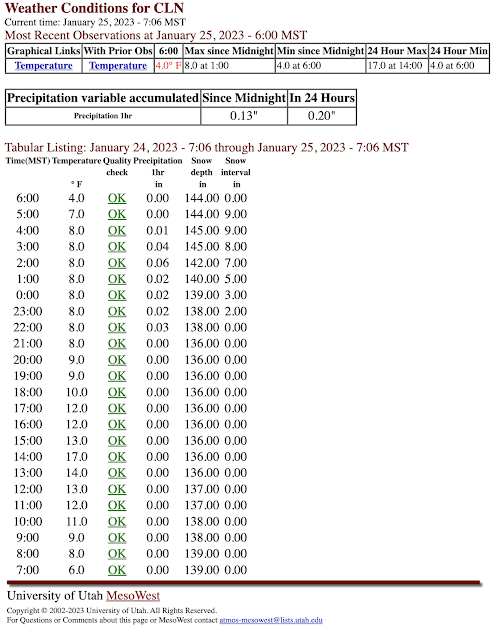
Nine inches of pixie dust fell at Alta-Collins last night. At the same time, precipitation gauge observations measured only 0.20" of water.
That equates to a snow-to-liquid ratio of 45:1, or a water content of a paltry 2.2%.Precipitation gauges often do not collect as much snow as is falling, yielding higher-than-actual snow-to-liquid ratios. Still, pretty likely that the snow was at least 35:1 or possibly 40:1, the latter a water content of 2.5%. That's pixie dust by any measure.
As discussed in my prior post, I expected "dribs and drabs" at times through today (Wednesday). From a water perspective, 0.2" of water is a "drib." At average snow-to-liquid ratios for Alta (12:1), that would translate to 2.4" of snow. Yawn.
However, at 40:1, its 8" of snow and at 45:1 you get 9". Voila!
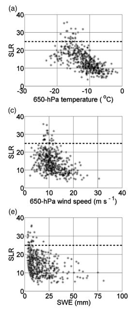
Some meteorologists call snow with snow-to-liquid ratios of 25:1 or greater wild snow. At Alta, about 6% of days with at least 2" of snow and 0.11" of water equivalent feature wild snow. Scattergrams show that nearly all wild-snow events (above the dashed lines) happen at Alta when the 650-hPa (about 11,500 feet or just above mountaintop level) temperature is between -12 and -19˚C, the wind speed is between about 7.5 and 12.5 meters per second (about 15 to 25 knots), and the water equivalent is less than 20 mm (0.8 inches).
 |
| Source: Alcott and Steenburgh (2010) |
Wild snow doesn't happen when the water equivalent is high because high water equivalent storms either occur with higher temperatures, which are less favorable for pristine dendrites, and tend to produce more compaction of the snow on the ground, making it harder to maintain large snow-to-liquid ratios.
Last night the winds on Mt. Baldy were actually moderately high, reaching as high as a sustained 35 mph with gusts as high as 54 mph. These equate to 30 and 47 knots and seem to be outside the range above. Wind speeds at 650 hPa this morning were also above 25 knots. Perhaps a larger sample size than we used above would broaden the range of winds for wild snow. Additionally, the winds last night dropped off quickly below 650 hPa so just below crest level the flow was weaker.
Forecasting these events is also exceptionally difficult. They are statistical outliers. Simple techniques for predicting snow-to-liquid ratio based on linear techniques don't even like to go much above 20:1. Other approaches, including human interpretation, might get them from time to time, but with a lot of false alarms to erode utility. It's a good problem for us to work on moving forward.


This is a great post. Thanks for setting aside time to keep cranking these posts out. I read it regularly and its content is totally applicable living in Crested Butte, guiding in British Columbia, or even when abroad. Let’s hope for more juicy “outlier mode” atmospheric conditions! Interesting storm in Japan recently too!
ReplyDeleteThanks Ian. Been meaning to talk with you about a little ski adventure idea I have. Drop me a note sometime when you get a chance. jim.steenburgh at gmail dot com.
DeleteWow. After all these years and snow, LCC blows my mind again. And then you ever so easily explain it and it blows my mind again. Chapeau!
ReplyDeleteHypothesis on the minimum wind speed: seems like these events are generally orographically based, since the other forms of lift would produce too much SWE or wind. Isn't some wind necessary for orographic precip? That would explain the minimum wind cutoff.
ReplyDelete