It's been a pretty crazy 24-hour period on the meteorological "front." Yesterday's high at KSLC was an incredible 104˚F. Not only is this an all-time record for September, but it is the highest temperature ever reported at KSLC after August 5th. Some colleagues of mine pointed out that this was 4˚F warmer than reported at surrounding sites. I have to concur that the airport highs seem jacked, whether it be instrument or siting characteristics. Nevertheless, 100-102 would still tie or beat the all-time for September, so it remains blisteringly hot for this time of year.
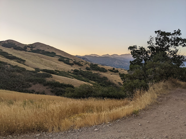
I took the picture below at about 7:20 this morning while mountain biking in the Avenues foothills. Notice anything unusual?
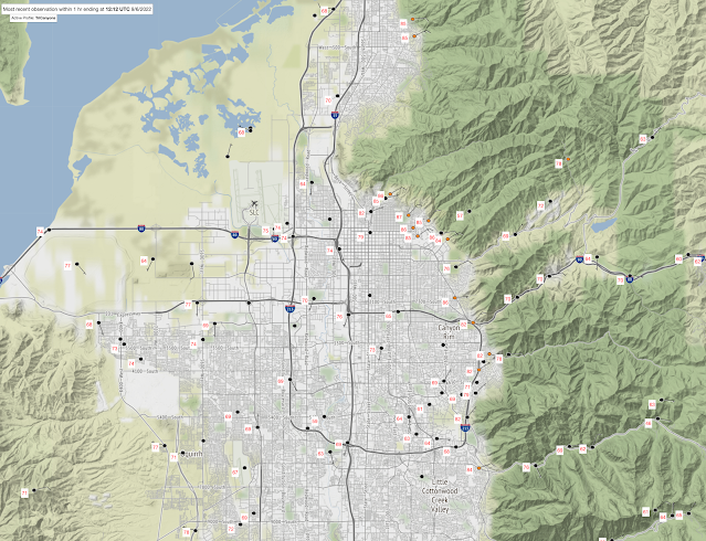
Ha ha. You can't see anything unusual, but the temperatures sure were. I woke up at 6 am and it was 80˚F at my house. 80! Overnight downslope winds in the University of Utah area kept overnight temperatures quite elevated. Surface observations at around 1200 UTC/0600 MDT showed NE flow around campus with temperatures 84-87˚F. Incredible!
What an insult to injury this September has been.
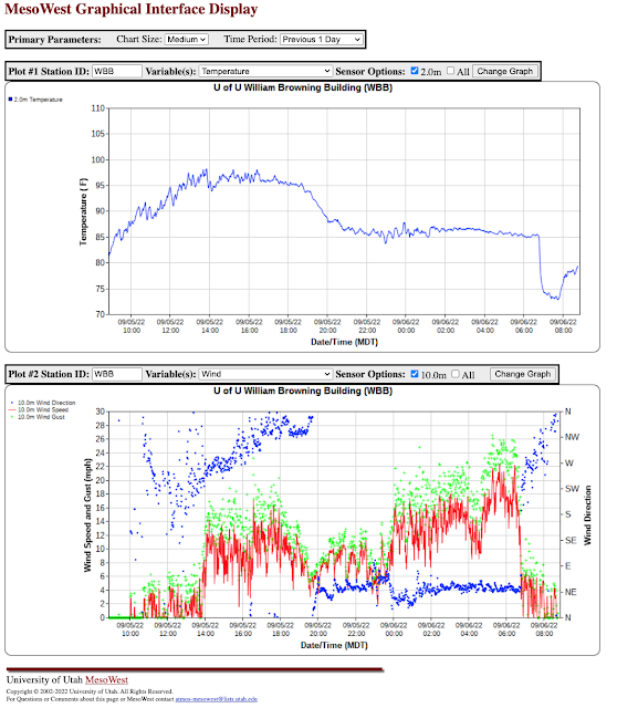
Observations from the William Browning Building on campus are quite interesting. They show overnight temperatures hovering near or just above 85˚F from about 2100 MDT yesterday to 0630 MDT this morning. During this period, the flow was easterly with gusts reaching as high as 28 mph. At a bit after 0630 MDT, however, the wind shifted and began to veer from southerly to northerly. As soon as the wind shifted from easterly, the temperature dropped more than 10˚F as the valley cold pool replaced the warm easterly flow.
Given the many complaints about KSLC, let's take a look at the first five days at Bountiful Bench where there is a complete record back to 1975.
Sep 1-5 Average Max Temperature: 93.8˚F (prior record 90.2˚F, Sep 1-5 1975)
Sep 1-5 Average Min Temperature: 71.6˚F (prior record 68.0˚F, Sep 1-5 1978)
The duration of this heat wave will cause greater separation as it continues. We will probably end up beating the 1-7 Sep records by about 4˚F.


When I was younger I would follow the terms on the NOAA public phone (521-3650 I think) Updates at the top of the hour, the wind would change from South West to North east in the afternoon and that was the end of the climbing temps. There used to be a much larger body of water to the West of the airport site, no so much the case anymore. PS 105 at the airport at this time.
ReplyDeleteI think the biggest factor in the "jacked" airport temps is the lack of any vegetation near the ASOS now. Look at historical imagery from a few years back and the area surrounding the site is bare ground or sand, where it used to be the brown grass typical of most undeveloped parts of the SL Valley (this has not changed at other surrounding sites, including UT215 at the I-215/80 interchange which has consistently been 2-5F lower than KSLC this summer). If a lower lake level were the primary culprit, you'd expect to see a similar outlier shift at UT215 and we really haven't seen that. Unfortunate that these issues are getting in the way of communicating what is otherwise a highly anomalous record breaking heatwave.
ReplyDeleteYes, "highly anomalous record breaking heatwave" is the right way to think about this early September insanity we are living.. It does seem 107 is the new 105/104. I remember when 107 was 107 in July 2002 and it was 2/3 degrees hotter than now. 104 is still hot as flip for Sep 7.
DeleteMore seriously, Jim, have you looked at the large scale processes that are causing this. Usually its a southerly flow bringing in hot air from lower latitudes but that doesn't seem to be the case for this current bout of insanity.
Seems like a plain vanilla multi-year or multi-decade drought cycle getting to its hottest point. Are you inclined to think this is unprecedented in that the KSLC location as never been 104 Sep 7 during the holocene, or that it hasn't been 104 for centuries or millennia.
The trend of climate change seems to be making the drought worse, but its hard to make attributions not knowing previous drought cycles from the distant past.
The simplest explanation is that we are directly under a high-amplitude ridge. In winter, this would be an awful inversion, but this time of year there is enough solar energy that we bake.
DeleteMy knowledge is for the recent past...meaning the past several decades. I'm not able to answer your question about centuries or millennia without a more careful look at the literature.
Got a wild hair and pulled the data for Sep 7 max. Range is 60 in both 1929 and 1939 (that 60 is the HIGH for Sep 7, not the low) to 99 in 1979.
DeleteOde to the days when 99 on Sep 7 was NOT hot.
Until now, since 2000 the Sep 7 high has never been above 93 (that temp was reached 2021, 2020 and 2017). The average high since 2000 is 85. Given 107 is the new 105/104, today we are 20 degrees hotter than the past two decade average, and 11/12 degress hotter than previous highs during the period.
We are several sigma out today in terms of heat. There's no obvious reason we should be 12 degrees hotter than last year. Be great to hear your thoughts on why Sep 7, 2022 in Salt Lake is so extraordinarily hot.
Did a math boo boo. 107 this year less 93 last year is 14 degrees.
DeleteWe are 14 degrees hotter this year than last.
Extraordinary
This was fairly predictable. The models have been calling for the warmest airmass to be today. It is the day of the maximum ridge strength and lower to middle atmosphere temperatures.
ReplyDeleteHeat waves are happening with intensities and durations that are increasingly unlikely prior to global warming. We can't blame this event on global warming. Natural variability played a role, but the warmer global temperatures are loading the dice.
A more difficult question to answer is the contribution of declining lake levels and the like. My thinking on this is that so many stations are setting records that's a minor player possibly at sites very near the lake.
This is not the new normal, but it is an example of how the probabilities of high temperature extremes are shifting. Buckle up.
Jim
Just curious if any of the weather professionals who comment on this blog and are based in SLC plan on retiring here? Serious question.
ReplyDelete