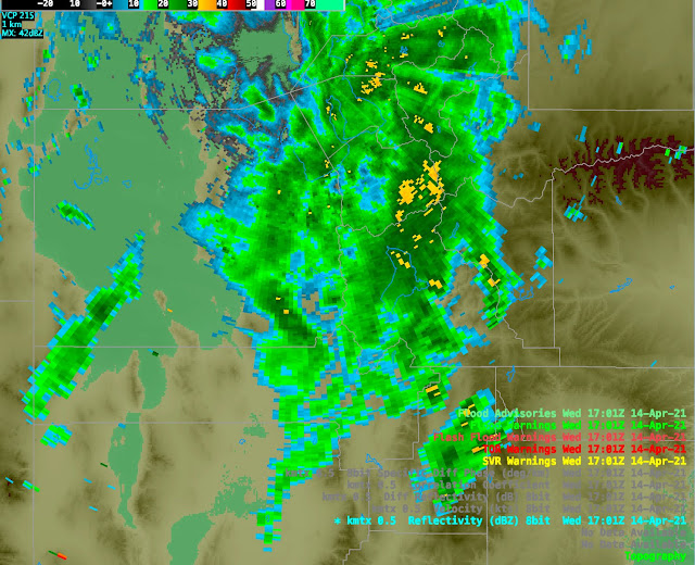
Pretty amazing storm yesterday as the "eastern band" discussed in yesterday's post intensified and delivered heavy snowfall to the central Wasatch Range yesterday morning. Snowfall rates peaked from 11-12 MDT with several automated observing sites from Little Cottonwood Canyon to Park City Mountain Resort recording more than 4" of snow in that hour. Alta-Collins ticked off 5.
Radar imagery at just after 11 am showed strong returns over the Cottonwoods and Park City Ridgeline. Even east of the crest, the reflectivities were quite high. Because of partial blockage of the outgoing radar energy by the Wasatch Range, there's less energy available to reflect back to the radar, so those are pretty healthy returns for east of the crest.
Consistent with the radar, we saw something that we haven't seen much of this winter: heavy snowfall in Park City and Summit Park. National Weather Service spotters reported 13" at 6824 feet in Park City through 2 PM yesterday and 17.5" in Summit Park through 6 PM.
Several factors probably contributed to these big amounts east of the crest. As discussed in yesterdays post, the upper-level flow was from the south-southwesterly, so shadowing effects were limited. Expanding on that point, the low-level, near surface flow at 11 am was either light or easterly at many locations in the central Wasatch. For example, Parley's summit reported a 15 knot east wind, Empire Peak at Deer Valley a 10 knot east-southeast wind, and sights in Brighton and Alta both reported winds with an easterly component.
So the situation was one with heavy snowfall being generated in a band in the south-southwest flow aloft, but the low-level flow producing upslope on the eastern slopes of the Wasatch Range. Snowfall was still very heavy west of the crest due to the influence of the band, but there was no shadowing effect on the east side and there may have even been an upslope affect to aid precipitation generation.
I also received an interesting photo from one of our readers, Mike Freeman. It was taken looking toward Parley's Canyon and Grandeur Peak at 3:32 PM MDT. Note how it appears that there's no wnow at mid elevations in the circled area, but snow at low elevations.
Is this simply an optical illusion? I suspect if you were walking up ridge on the right in the oval you'd go from snow to no snow.
I have a few hypotheses for why this happened, but encourage you to share your ideas for how this occurred in the comments.


While driving up to LCC ~1030am yesterday I was surprised when valley rain quickly changed to extremely heavy, wind driven snow near the mouth of Parleys. At the same time, I couldn't see any snow on Olympus below maybe 6500-7000ft. On the drive home there was still some snow on the ground and even the shoulder despite mid 40s temps and quite a bit of sun.
ReplyDeleteI'm curious to hear your hypotheses.
I frequently take my dog to this area in the early morning during the cool season. I've noticed the classic downslope winds out of Parleys tend to extend to the snowy part of the circled area (main west face trail). Once you get above the red circle, or if you take the dragon's tail route (part without snow), you're out of the wind. With winds coming out of Parleys throughout this event, my thought is that cold air is being advected across the snowy circled area, and/or the wind is enhancing evaporative cooling, allowing the snow to stick. Perhaps a more reasonable guess is isolated/scattered precipitation, but that's no fun.
ReplyDeleteI don't think I can attach pics/vids here, but took some at Solitude Yesterday and made them "Public" on my FB page, in case anyone is interested (and has FB). https://www.facebook.com/permalink.php?story_fbid=1251565755240621&id=100011616245210&comment_id=1252049518525578¬if_id=1618503837897160¬if_t=feed_comment&ref=notif
ReplyDeleteWe saw that odd snow coverage while driving on I-80 to I-215 at about 4:45. It looked more pronounced in person than it does in the photo. When we saw it some of the lower elevation snow had melted off but the north side of the lower to mid ridge line was white, while everything to the south was not. I don't think it was and illusion.
ReplyDeleteInteresting post and photo. I drove along north onto Foothill at about noon on 4/14. As I drove along 215, the temperature (according to my car) was 37 F and it was raining steadily. As I passed by the 3300 S exit, the rain rapidly transitioned to heavy snow, and at the mouth of the canyon, it was full on winter with snow built up on the road. Driving was a little unnerving. It looked like it had snowed 2-3 inches rapidly. As I got a short distance down Foothill (maybe a little past the Bjorn's Brew), the snow turned to a rain/snow mix and there was just a trace of snow on the grass and the roads were completely clear. It amazed me how quickly the weather changed in both directions there.
ReplyDeleteThat's consistent with cold outflow from Parley's locally lowering the snow level.
DeleteI live in Kimball Jxn and that was the wettest snow I've seen in six years.
ReplyDelete